Diemen: Difference between revisions
WhatsUpWorld (talk | contribs) No edit summary |
WhatsUpWorld (talk | contribs) Fixed typo Tags: Mobile edit Mobile app edit |
||
| Line 81: | Line 81: | ||
| footnotes = |
| footnotes = |
||
}} |
}} |
||
'''Diemen''' ({{IPA-nl|ˈdimə(n)|-|Nl-Diemen.ogg}}) is a [[Dorp (town)|town]] and [[Municipalities of the Netherlands|municipality]] with a population of {{formatnum:{{Dutch municipality population|Diemen}}}} in the [[Provinces of the Netherlands|province]] of [[North Holland]], [[Netherlands]]. It is located approximately 6 |
'''Diemen''' ({{IPA-nl|ˈdimə(n)|-|Nl-Diemen.ogg}}) is a [[Dorp (town)|town]] and [[Municipalities of the Netherlands|municipality]] with a population of {{formatnum:{{Dutch municipality population|Diemen}}}} in the [[Provinces of the Netherlands|province]] of [[North Holland]], [[Netherlands]]. It is located approximately 6 kilometres southeast of [[Amsterdam]]'s [[Amsterdam-Centrum|city centre]], within the [[Amsterdam metropolitan area]]. |
||
== Etymology == |
== Etymology == |
||
Revision as of 01:54, 18 February 2018
Diemen | |
|---|---|
Town and municipality | |
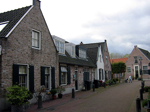 Street in Diemen with recreated traditional houses in 2004 | |
 Flag Coat of arms | |
 Location in North Holland and the Netherlands | |
| Coordinates: 52°20′N 4°58′E / 52.333°N 4.967°E | |
| Country | Netherlands |
| Province | |
| Government | |
| • Body | Municipal council |
| • Mayor | Erik Boog (D66) |
| Area | |
| • Total | 14.04 km2 (5.42 sq mi) |
| • Land | 11.99 km2 (4.63 sq mi) |
| • Water | 2.05 km2 (0.79 sq mi) |
| Elevation | −1 m (−3 ft) |
| Population (January 2021)[4] | |
| • Total | 31,334 |
| • Density | 2,613/km2 (6,770/sq mi) |
| Demonym | Diemenaar |
| Time zone | UTC+1 (CET) |
| • Summer (DST) | UTC+2 (CEST) |
| Postcode | 1110–1113 |
| Area code | 020 |
| Website | www |
Diemen (Dutch pronunciation: [ˈdimə(n)] ) is a town and municipality with a population of 31,334 in the province of North Holland, Netherlands. It is located approximately 6 kilometres southeast of Amsterdam's city centre, within the Amsterdam metropolitan area.
Etymology
The name Diemen comes from the river Diem, which originates from die eme, meaning the water.[5]
Geography

Diemen is located in the province North Holland, in the west of the Netherlands. The town is part of the urban area of Amsterdam and is situated between Amsterdam-Oost (IJburg, Watergraafsmeer), Ouder-Amstel (Duivendrecht), Amsterdam-Zuidoost (Bijlmer, Driemond), and Muiden.
Three waterways cross the municipality: the Weespertrekvaart from west to south, the Amsterdam-Rhine Canal from north to east, and the river Diem from south to north. The river is the namesake of Diemen. The town can be divided into three neighbourhoods: Diemen Noord, Diemen Centrum, and Diemen Zuid.
Diemen Noord (English: Diemen North) is located on the south bank of the Amsterdam–Rhine Canal, which separates it from the Amsterdam neighbourhood IJburg, on the west bank of the river Diem, and on the north side of the Amsterdam–Zutphen railway. The area contains houses, a few of which are recreated old houses, a minor shopping centre, and in the east a green area called Diemerpolder.
Diemen Centrum (English: Diemen Centre) extends from the Watergraafsmeer in the west, from which it is separated by the A10 motorway, all the way to the north-east of municipality with the rural area Overdiemerpolder, an electricity plant, and the green area Diemervijfhoek. The neighbourhood contains houses and apartment buildings, the largest shopping centre, and the town hall. The train station Diemen is located between Noord and Centrum.
Diemen Zuid (English: Diemen South) is located next to Duivendrecht, Bijlmer, and Driemond. It contains houses and apartment buildings, a minor shopping centre, and a location of Inholland University of Applied Sciences. On the south-west border is the railway station Diemen Zuid for metros and trains. The east part of the neighbourhood contains an industrial area and a green area called Diemerbos.
Demographics
The municipality has a population of 25,915 and a population density of 2,161/km2 (5,600/sq mi).[6]
Government
The municipal government consists of the executive college of the mayor and aldermen and the elected municipal council. The municipal building is located at the D.J. den Hartoglaan 1.
After the 2010 local elections in the Netherlands, a coalition of Labour Party (PvdA), GreenLeft (GL), Democrats 66 (D66), and Socialist Party (SP) was formed in Diemen. The college van burgemeester en wethouders consists of the appointed mayor Amy Koopmanschap (GL) and the four aldermen Lex Scholten (PvdA), Ruud Grondel (GroenLinks), Jeannette Pietersen (D66), Maïta van der Mark (SP), one of each coalition party.[7]
The municipal council of Diemen consists of 21 elected members, the seats are divided as follows:[8]
- PvdA - 4 seats
- VVD - 3 seats
- Leefbaar Diemen - 3 seats
- D66 - 3 seat
- SP - 3 seats
- GreenLeft - 2 seats
- Partij van de Ouderen - 2 seats
- CDA - 1 seats
Transportation

The motorways A1 (E231) and A9 pass through the municipality of Diemen, and the motorway A10 (Amsterdam ring) lies just outside the municipal border with Amsterdam.
Diemen has two train stations, Diemen on the Amsterdam–Zutphen railway and Diemen Zuid on the Weesp–Leiden railway. All train services to and from Diemen are operated by the Nederlandse Spoorwegen (NS). The railway station Diemen Zuid connects the town to the metro network of the Gemeentelijk Vervoerbedrijf (GVB).
Tram (line 9), bus and night bus services connect Diemen to Amsterdam and other towns in the area.
Bus service line 44 drives from Diemen North to the railway and metrostation Amsterdam Bijlmer Arena
Education

There are seven primary schools in Diemen. The three public schools are De Octopus, De Venser, and 't Palet. The two ecumenical schools are De Ark and De Duif. The school De Kersenboom is both public and ecumenical. De Nieuwe Kring is a Jenaplan school and Sint-Petrusschool is a Roman Catholic school.[9]
There are no secondary schools in Diemen. The nearest secondary schools are in Amsterdam and Weesp.[10]
There are two institutes of tertiary education in Diemen: the universities of applied sciences HBO Nederland and Inholland both have a location in Diemen Zuid.[11] The nearest universities are in Amsterdam.
References
- ^ "College van B&W – Wie is wie" (in Dutch). Municipality of Diemen. Archived from the original on 21 June 2015. Retrieved 21 June 2015.
{{cite web}}: Unknown parameter|deadurl=ignored (|url-status=suggested) (help) - ^ "Kerncijfers wijken en buurten 2020" [Key figures for neighbourhoods 2020]. StatLine (in Dutch). CBS. 24 July 2020. Retrieved 19 September 2020.
- ^ "Postcodetool for 1111ZB". Actueel Hoogtebestand Nederland (in Dutch). Het Waterschapshuis. Retrieved 27 February 2014.
- ^ "Bevolkingsontwikkeling; regio per maand" [Population growth; regions per month]. CBS Statline (in Dutch). CBS. 1 January 2021. Retrieved 2 January 2022.
- ^ Template:Nl icon Diemen, Vroegmiddelnederlands Woordenboek. Retrieved on 4 March 2014.
- ^ "Bevolkingsontwikkeling; regio per maand" [Population growth; regions per month]. CBS Statline (in Dutch). CBS. 23 December 2013. Retrieved 24 December 2013.
- ^ "Archived copy". Archived from the original on 13 September 2010. Retrieved 14 August 2010.
{{cite web}}: Unknown parameter|deadurl=ignored (|url-status=suggested) (help)CS1 maint: archived copy as title (link) - ^ "Archived copy". Archived from the original on 13 September 2010. Retrieved 12 August 2010.
{{cite web}}: Unknown parameter|deadurl=ignored (|url-status=suggested) (help)CS1 maint: archived copy as title (link) - ^ Template:Nl icon Basisonderwijs, Lokaaltotaal.nl/Diemen. Retrieved on 2013-05-22.
- ^ Template:Nl icon Voortgezet onderwijs, Lokaaltotaal.nl/Diemen. Retrieved on 2013-05-22.
- ^ Template:Nl icon HBO, Lokaaltotaal.nl/Diemen. Retrieved on 2013-05-22.
External links
Media related to Diemen at Wikimedia Commons
- Template:Nl icon Official website
Places adjacent to Diemen | |
|---|---|

| International | |
|---|---|
| National | |
| Geographic | |