The introductions of the country, dependency and region entries are in the native languages and in English. The other introductions are in English.
| |
|
Atlas-country

|
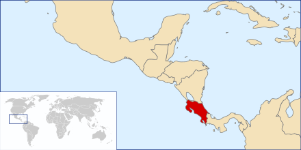
Costa Rica
|
|
|
|
|
|
|
|
Costa Rica
|
|
|
|
| Español
|
Costa Rica - República de Costa Rica
La República de Costa Rica es un país de América Central. Limita al norte con Nicaragua, al sureste con Panamá, su territorio es bañado al este por el Mar Caribe y al oeste por el Océano Pacífico.
|
| English
|
Costa Rica - Republic of Costa Rica
The Republic of Costa Rica (literally 'rich coast') is a country in Central America, bordered by ► Nicaragua to the north, ► Panama to the south-southeast, the Pacific Ocean to the west and south, and the Caribbean Sea to the east.
|
|
|
|
| Short name
|
Costa Rica
|
| Official name
|
Republic of Costa Rica
|
| Status
|
Independent country since September 15, 1821.
|
| Location
|
Central America
|
| Capital
|
San José
|
| Population
|
5,111,238 inhabitants
|
| Area
|
51,100 square kilometres (19,700 sq mi)
|
| Major languages
|
Spanish
|
| Major religions
|
Roman Catholicism
|
| More information
|
Costa Rica, Geography of Costa Rica, History of Costa Rica and Politics of Costa Rica
|
| More images
|
Costa Rica - Costa Rica (Category).
|
|
General maps

|
Mapa de Costa Rica
Map of Costa Rica
|

|
Mapa de Costa Rica
Map of Costa Rica
|

|
Mapa física de Costa Rica
Physical map of Costa Rica
|

|
Mapa de Costa Rica
Map of Costa Rica
|

|
Mapa de Costa Rica
Map of Costa Rica
|
History maps
This section holds a short summary of the history of the area of present-day Costa Rica, illustrated with maps, including historical maps of former countries and empires that included present-day Costa Rica.

|
Costa Rica as part of the Spanish colonial Empire
|
Old maps
This section holds copies of original general maps more than 70 years old.

|
Central America in 1892
|
Other maps

|
Districts of San Jose
|

|
Barrios of San Jose
|
Notes and references
General remarks:
- The WIKIMEDIA COMMONS Atlas of the World is an organized and commented collection of geographical, political and historical maps available at Wikimedia Commons. The main page is therefore the portal to maps and cartography on Wikimedia. That page contains links to entries by country, continent and by topic as well as general notes and references.
- Every entry has an introduction section in English. If other languages are native and/or official in an entity, introductions in other languages are added in separate sections. The text of the introduction(s) is based on the content of the Wikipedia encyclopedia. For sources of the introduction see therefore the Wikipedia entries linked to. The same goes for the texts in the history sections.
- Historical maps are included in the continent, country and dependency entries.
- The status of various entities is disputed. See the content for the entities concerned.
- The maps of former countries that are more or less continued by a present-day country or had a territory included in only one or two countries are included in the atlas of the present-day country. For example the Ottoman Empire can be found in the Atlas of Turkey.
|
Entries available in the atlas
- General pages
- World
- Continents and oceans
- Themes
- Historical eras
- States with wide recognition
- States with limited recognition
- Dependencies and other overseas territories
- Country subdivisions
- Belgium
- China (mainland)
- India
- Pakistan
- Spain
- United Kingdom
- United States
- Other
- Disputed subnational territories
- Other regions
- Cities
- Former sovereign states
- Former dependencies and overseas territories
- Former disputed territories
|