Category:Aquifers
Vai alla navigazione
Vai alla ricerca
Català: Aqüífer
Deutsch: Grundwasserleiter
English: Aquifer
Español: Acuífero
Français : Aquifère
Galego: Acuífero
עברית: אקוויפר
Italiano: Acquifero
Lietuvių: Vandeningas sluoksnis
Nederlands: Aquifer
日本語: 帯水層
Português: Aquífero
Slovenčina: Akvifer
Svenska: Akvifär
Türkçe: Akifer
zona di rocce impermeabili in cui è presente acqua  | |||||
| Carica un file multimediale | |||||
| Sottoclasse di | |||||
|---|---|---|---|---|---|
| Aspetto di | |||||
| Distinto da | |||||
| |||||
Sottocategorie
Questa categoria contiene le 7 sottocategorie indicate di seguito, su un totale di 7.
File nella categoria "Aquifers"
Questa categoria contiene 43 file, indicati di seguito, su un totale di 43.
-
1 - Ingungumanti.png 826 × 521; 20 KB
-
Alter do Chão.png 586 × 382; 47 KB
-
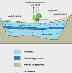
Aquifer eu.png 1 371 × 1 387; 348 KB
-
Aquifersalt.jpg 777 × 435; 30 KB
-
Cambrian-Ordovician Aquifer System.webp 352 × 377; 20 KB
-
ETH-BIB-Erdöl-Antiklinalen-Dia 247-Z-00271.tif 3 652 × 2 830; 29,69 MB
-
Fresh water coming out on the beach.jpg 4 000 × 3 000; 1,16 MB
-
Groundwater (Aquifer & Aquitard).PNG 980 × 550; 62 KB
-
Groundwater (aquifer, aquitard, 3 type wells).PNG 1 000 × 680; 71 KB
-
Groundwater flow NL.svg 645 × 400; 226 KB
-
Groundwater flow.svg 645 × 400; 86 KB
-
Groundwater he.png 552 × 600; 73 KB
-
Groundwater Lowering.jpg 640 × 480; 85 KB
-
Groundwater model.jpeg 1 124 × 1 240; 144 KB
-
Groundwater zone.png 535 × 303; 108 KB
-
Groundwater-fluoride-world.svg 940 × 415; 1,49 MB
-
Groundwater.png 1 286 × 1 397; 251 KB
-
HeatAndColdStorageWithHeatPump vi.svg 512 × 328; 10 KB
-
HeatAndColdStorageWithHeatPump.jpg 2 592 × 1 316; 260 KB
-
HeatAndColdStorageWithHeatPump.svg 512 × 356; 16 KB
-
Intergranularna poroznost.jpg 690 × 690; 215 KB
-
Kavernozna poroznost.jpg 683 × 685; 201 KB
-
Khattara.png 1 026 × 704; 190 KB
-
Natural-seepage-field-model-of-the-dam-area.jpg 600 × 470; 109 KB
-
Physical Aquifer Model.jpg 3 264 × 1 836; 1,69 MB
-
-
Principle aquifer withdrawals 2000.png 903 × 618; 81 KB
-
Pukotinska poroznost.jpg 690 × 685; 208 KB
-
Sabbia1.jpg 1 556 × 703; 964 KB
-
Saga SistemaAquíferoGrandeAmazônia.png 586 × 382; 37 KB
-
Salt water intrusion wikipedia2.png 9 983 × 6 249; 13,69 MB
-
Saltwater Intrusion Cause and Impact.jpg 8 243 × 5 934; 9,62 MB
-
Saltwater intrusion en.svg 512 × 213; 17 KB
-
Saltwater intrusion fa.svg 512 × 512; 3 KB
-
Saltwater Intrusion.gif 633 × 260; 13 KB
-
Schematic aquifer xsection usgs cir1186.png 400 × 431; 51 KB
-
Strefa kapilarna.jpg 412 × 414; 16 KB
-
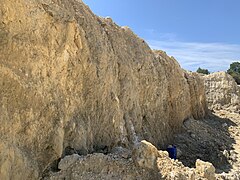
Suwannee limestone exposure.jpg 4 032 × 3 024; 4,59 MB
-
Suwanneelimecheese.jpg 4 032 × 3 024; 7,19 MB
-
Theis Equation.png 1 276 × 705; 183 KB
-
Type of aquifers.png 546 × 354; 90 KB
-
Water seep from sandstone in Hanging Garden SE Utah.jpg 650 × 433; 111 KB
-
जलस्तर .svg 672 × 665; 42 KB