Category:Klamath Mountains
Zur Navigation springen
Zur Suche springen
Gebirgszug   | |||||
| Medium hochladen | |||||
| Ist ein(e) | |||||
|---|---|---|---|---|---|
| Ort |
| ||||
| Breite |
| ||||
| Länge |
| ||||
| Gebirgszug | |||||
| Höchster Punkt | |||||
| Fläche |
| ||||
| Höhe über dem Meeresspiegel |
| ||||
 | |||||
Unterkategorien
Es werden 20 von insgesamt 20 Unterkategorien in dieser Kategorie angezeigt:
In Klammern die Anzahl der enthaltenen Kategorien (K), Seiten (S), Dateien (D)
*
B
- Bolan Mountain Lookout (1 D)
C
G
K
- Kerby Peak Trail (22 D)
- King Mountain (34 D)
M
R
S
- Siskiyou Summit (12 D)
T
W
Y
Seiten in der Kategorie „Klamath Mountains“
Diese Kategorie enthält nur die folgende Seite.
Medien in der Kategorie „Klamath Mountains“
Folgende 53 Dateien sind in dieser Kategorie, von 53 insgesamt.
-
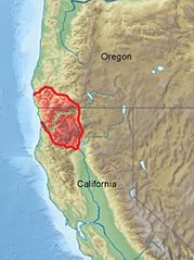
Klamath Mountains map.gif 515 × 684; 33 KB
-
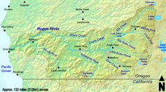
Roguerivermap.png 954 × 623; 1,09 MB
-
Siskiyou mountains.jpg 300 × 180; 33 KB
-
-
-
Alpine Wet Meadow in the Klamath Mountains (8794738958).jpg 3.264 × 2.448; 2,72 MB
-
Bolan Mountain Lookout Tower, Siskiyou Forest, California , 1919. - NARA - 299162.tif 1.740 × 3.000; 4,98 MB
-
CALIFORNIA-NEAR KLAMATH - NARA - 542844.jpg 2.029 × 3.000; 1,27 MB
-
Carte de localisation des monts Klamath.jpg 800 × 1.069; 363 KB
-
Carte-de-localisation-des-monts-Klamath.png 612 × 792; 625 KB
-
Chetco River Watershed.png 1.500 × 1.000; 1,8 MB
-
Chetco River2.jpg 672 × 440; 79 KB
-
-
Emerald lake trinity alps.jpg 2.048 × 1.536; 1,39 MB
-
Full moon over the Siskiyous by Gary Muir (8273187692).jpg 2.754 × 1.890; 2,47 MB
-
Grassy Knob Wilderness.jpg 437 × 290; 28 KB
-
Highway 96 dry side of Klamath Mountains (10242847626).jpg 1.280 × 960; 532 KB
-
Klamath Basin mountains (5709878501).jpg 3.632 × 2.440; 1,84 MB
-
Klamath ecoregion California.gif 784 × 1.324; 167 KB
-
Klamath ecoregion Oregon.gif 1.042 × 1.138; 126 KB
-
Klamath Mountains location map.jpg 800 × 1.069; 377 KB
-
Klamath-Siskiyou Forests map.svg 1.712 × 1.992; 336 KB
-
Level IV ecoregions, Klamath Mountains.png 502 × 577; 196 KB
-
Loop and tunnels, Siskiyou Mountains, California-LCCN2008678189.jpg 7.353 × 5.559; 7,96 MB
-
Loop and tunnels, Siskiyou Mountains, California-LCCN2008678189.tif 7.353 × 5.559; 116,97 MB
-
Mt-Linn-Sunrise.jpg 800 × 374; 115 KB
-
-
Pacific Crest Trail Scott Mountains.jpg 1.000 × 666; 496 KB
-
Pacific silver fir and English Peak.jpg 600 × 900; 329 KB
-
Picea breweriana foliage.JPG 2.592 × 1.944; 2,19 MB
-
Picea brewerianafullform.JPG 1.944 × 2.592; 1,39 MB
-
Pinus monticola Bear Creek Canyon.jpg 2.253 × 1.729; 3,42 MB
-
Rogue River Watershed.png 1.459 × 809; 1,45 MB
-
Sawtooth Alpenglow (3628737331).jpg 852 × 1.280; 1,62 MB
-
Sawtooth Fire (3620631425).jpg 852 × 1.280; 1,78 MB
-
Serpentine-Siskiyou-1.jpg 650 × 473; 60 KB
-
Shasta Valley from Pilot Rock.JPG 4.320 × 3.240; 5,07 MB
-
-
-
-
Siskiyou Mountains panoramic view north.JPG 4.096 × 644; 757 KB
-
Siskiyou Mountains, West Shore magazine, 1887.jpg 594 × 944; 147 KB
-
Siskiyou NF Oregon Caves.jpg 3.072 × 2.048; 1,32 MB
-
Trinity Alps Wilderness with Pinus balfouriana.jpg 3.646 × 2.430; 4,76 MB
-
USA Region West relief Klamath Mountains location map.jpg 1.867 × 2.091; 1,05 MB
-
USA Region West relief Marble Mountains location map.jpg 1.867 × 2.091; 1,05 MB
-
USA Region West relief Siskiyou Mountains location map.jpg 1.867 × 2.091; 1,05 MB
-
USA Region West relief Trinity Mountains location map.jpg 1.867 × 2.091; 1,02 MB
-
View north from Siskiyous in CA.JPG 4.608 × 3.456; 3,42 MB
-
Yolla-bolly-wilderness.jpg 700 × 467; 147 KB
-
KlamathBasin-location.jpg 768 × 1.000; 261 KB
-
-


Kategorien:
- Mountain ranges of Northern California
- Mountain ranges of Oregon
- Pacific Coast Ranges
- Geography of Del Norte County, California
- Geography of Humboldt County, California
- Geography of Siskiyou County, California
- Geography of Trinity County, California
- Jackson County, Oregon
- Curry County, Oregon
- Josephine County, Oregon