Île-de-France: Difference between revisions
No edit summary |
→Timeline: Moving to Ile de France (province) article |
||
| Line 34: | Line 34: | ||
==History== |
==History== |
||
===Timeline=== |
===Timeline=== |
||
*[[1181]]: King Philip II cancels 80 percent of all debts owed to Jews; the remaining 20 percent was to be paid directly to the king. |
|||
*[[1182]]: King Philip II expels the Jews from the Île-de-France |
|||
*[[1959]]: [[February 4]], "District of the Paris Region" ({{lang-fr|district de la région de Paris}}) created by a government decree. This creation was a failure, due to a lack of cooperation from the [[commune in France|communes]] and the [[departments of France|departments]] of the Paris region which refused to send their representatives to the district council. |
*[[1959]]: [[February 4]], "District of the Paris Region" ({{lang-fr|district de la région de Paris}}) created by a government decree. This creation was a failure, due to a lack of cooperation from the [[commune in France|communes]] and the [[departments of France|departments]] of the Paris region which refused to send their representatives to the district council. |
||
*[[1961]]: [[August 2]], District of the Paris Region re-created with the same name, but this time by a statute (bill) voted by the French Parliament. The limits of this new District of the Paris Region were exactly the same as the current Île-de-France region. The district council of the aborted 1959 District of the Paris Region was replaced by a Board of Trustees, half of whose members were appointed by the French government, the other half by the local communes and departments. The executive of the district was a civil servant, the Delegate General for the District of the Paris Region, appointed by the French government. |
*[[1961]]: [[August 2]], District of the Paris Region re-created with the same name, but this time by a statute (bill) voted by the French Parliament. The limits of this new District of the Paris Region were exactly the same as the current Île-de-France region. The district council of the aborted 1959 District of the Paris Region was replaced by a Board of Trustees, half of whose members were appointed by the French government, the other half by the local communes and departments. The executive of the district was a civil servant, the Delegate General for the District of the Paris Region, appointed by the French government. |
||
Revision as of 17:21, 12 May 2008
This article needs additional citations for verification. (February 2008) |
Template:Infobox French region Île-de-France (pronounced /il də fʁɑ̃s/; literally "Island of France") is one of the twenty-six administrative regions of France. Created as the "District of the Paris Region" in 1961, it was renamed as the "Île-de-France" région in 1976 when its administrative status was aligned with the other French administrative regions created in 1972. Despite the name change, Île-de-France is still popularly referred to by French people as the Région Parisienne ("Paris Region") or RP. Ninety percent of its territory is covered by the Paris aire urbaine (or "metropolitan area") which extends beyond its borders in places.[1]
With 11.6 million inhabitants Île-de-France is the most populated region of France. It has more residents than Belgium, Greece, Austria, Portugal or Sweden, and a comparable population to the U.S. state of Ohio and the Canadian province of Ontario. It is the fourth most populous country subdivision in the European Union after England, North Rhine-Westphalia and Bavaria.
Economically, Île-de-France is one of the richest regions in the world: its total GDP was €500.8 billion in 2006 (US$629.2 billion at 2006 real exchange rates), nearly the entire GDP of the Netherlands, with a per capita GDP at €43,370 (US$54,482) the same year.[2]
History
Timeline
- 1959: February 4, "District of the Paris Region" (French: district de la région de Paris) created by a government decree. This creation was a failure, due to a lack of cooperation from the communes and the departments of the Paris region which refused to send their representatives to the district council.
- 1961: August 2, District of the Paris Region re-created with the same name, but this time by a statute (bill) voted by the French Parliament. The limits of this new District of the Paris Region were exactly the same as the current Île-de-France region. The district council of the aborted 1959 District of the Paris Region was replaced by a Board of Trustees, half of whose members were appointed by the French government, the other half by the local communes and departments. The executive of the district was a civil servant, the Delegate General for the District of the Paris Region, appointed by the French government.
- 1966: August 10: creation of the Prefecture of the Paris Region, whose limits corresponded exactly to the current Île-de-France region. The Delegate General for the District of the Paris Region was made Prefect of the Paris Region, holding both offices at the same time.
- 1966: December 17: in French the "district de la région de Paris" was renamed "district de la région parisienne" (same meaning in English).
- 1976: May 6: the District of the Paris Region was transformed into the Île-de-France region, thus aligning the status of the Paris Region with that of other French regions, which possessed their status since 1972. The Prefecture of the Paris Region was renamed Prefecture of Île-de-France. The former Board of Trustees was replaced by a regional council, 70% of whose members were the representatives of the departments and communes of Île-de-France, while the remaining 30% were chosen by the Members of the French Parliament whose constituencies lay inside Île-de-France. The regional council elected a president, whose executive powers were limited. The office of Delegate General was abolished. It is said that President Valéry Giscard d'Estaing personally insisted on choosing the name "Île-de-France" for the region, instead of the hitherto used Région Parisienne. Île-de-France was the name of the historical province that existed before the French Revolution, but the name had long since fallen out of use. Today, many people and even some official institutions still continue to use the term "Région Parisienne" instead of the official "Île-de-France".
- 1982: March 2: Île-de-France, like the other French regions, was turned into a "territorial collectivity", i.e., it is no more a mere administrative structure, but a full-fledged political entity, on par with the departments and communes. The powers of the regions were expanded, direct elections of the regional councils were scheduled, and the presidents of the regional councils were given full executive powers.
- 1986: March 16: first direct election of the regional council by the inhabitants of Île-de-France. The powers and visibility of the Île-de-France region are henceforth greatly increased.
Geography
Île-de-France has a land area of 12,011 km² (4,637 sq. miles). The built-up area of Paris fills its 12,011 km² to near 23%[citation needed], and the Paris aire urbaine (or "metropolitan area", a built-up area + commuter belt) extends beyond its borders in places.
This section needs expansion. You can help by adding to it. |
Demographics
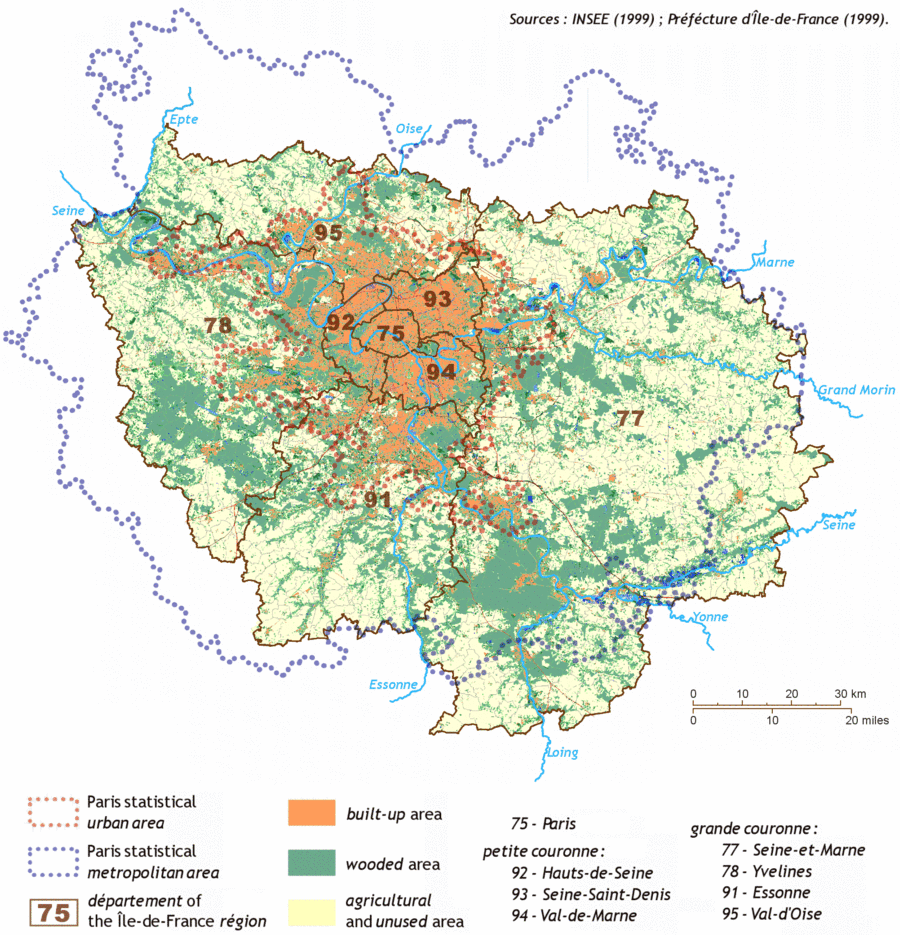
Île-de-France is composed of eight departments centered around its innermost department and capital, Paris. Around the department of Paris, urbanization fills a first concentric ring of three departments commonly known as the petite couronne ("small ring"), and extends into a second outer ring of four departments known as the grande couronne ("large ring").
Most of Île-de-France is covered by the Paris aire urbaine (or "metropolitan area"), a statistical area encompassing the Paris pôle urbain (or "urban area") and its couronne périurbaine commuter belt. At the last census in 1999, 88% of the Île-de-France's population lived in the Paris urban area and 99% of the same regional population lived in the Paris aire urbaine (respectively 9,644,507 people and 10,842,037 people).[3]
 | |||||
| Concentric Area | Departments | Population 2006 est. |
Area | Density | 1999-2006 yearly pop. growth |
|---|---|---|---|---|---|
| Paris (75) | 2,168,000 | 105 km² | 20,648/km² | +0.3% | |
| Inner ring (Petite Couronne) |
Hauts-de-Seine (92) | 1,532,000 | 176 km² | 8,705/km² | +1.0% |
| Seine-Saint-Denis (93) | 1,485,000 | 236 km² | 6,292/km² | +1.0% | |
| Val-de-Marne (94) | 1,293,000 | 245 km² | 5,278/km² | +0.8% | |
| Outer ring (Grande Couronne) |
Val-d'Oise (95) | 1,153,500 | 1,246 km² | 926/km² | +0.6% |
| Essonne (91) | 1,193,500 | 1,804 km² | 662/km² | +0.7% | |
| Yvelines (78) | 1,398,500 | 2,284 km² | 612/km² | +0.5% | |
| Seine-et-Marne (77) | 1,267,500 | 5,915 km² | 214/km² | +0.9% | |
Historical population
| 1801 census |
1806 census |
1821 census |
1826 census |
1831 census |
1836 census |
1841 census |
1846 census |
1851 census |
1856 census |
1861 census |
1866 census |
1872 census |
|---|---|---|---|---|---|---|---|---|---|---|---|---|
| 1,352,280 | 1,407,272 | 1,549,811 | 1,780,900 | 1,707,181 | 1,882,354 | 1,998,862 | 2,180,100 | 2,239,695 | 2,552,980 | 2,819,045 | 3,039,043 | 3,141,730 |
| 1876 census |
1881 census |
1886 census |
1891 census |
1896 census |
1901 census |
1906 census |
1911 census |
1921 census |
1926 census |
1931 census |
1936 census |
1946 census |
| 3,320,162 | 3,726,118 | 3,934,314 | 4,126,932 | 4,368,656 | 4,735,580 | 4,960,310 | 5,335,220 | 5,682,598 | 6,146,178 | 6,705,579 | 6,785,750 | 6,597,758 |
| 1954 census |
1962 census |
1968 census |
1975 census |
1982 census |
1990 census |
1999 census |
2002 estimate |
2003 estimate |
2004 estimate |
2005 estimate |
2006 estimate |
2007 estimate |
| 7,317,063 | 8,470,015 | 9,248,631 | 9,878,565 | 10,073,059 | 10,660,554 | 10,952,011 | 11,176,008 | 11,250,617 | 11,319,972 | 11,399,319 | 11,490,968 | 11,577,000 |
| Census returns before 2000; official Jan. 1 estimates from INSEE after 2000. | ||||||||||||
Immigration
Paris and the Île-de-France region is a magnet for immigrants, hosting one of the largest concentrations of immigrants in Europe. At the French census of March 1999, 2,159,070 residents of the Île-de-France region were people born outside Metropolitan France, making up 19.7% of the Île-de-France total population.[4] Among these people born outside Metropolitan France, 1,611,989 were immigrants (see definition below the table), making up 14.7% of the Île-de-France total population.[5] INSEE estimates that on January 1, 2005 the number of immigrants in Île-de-France has reached 1,916,000, making up 16.7% of the Île-de-France total population.[6] This is an increase of 304,000 immigrants in slightly less than six years.
| Born in metropolitan France | Born outside metropolitan France | |||
|---|---|---|---|---|
| 80.3% | 19.7% | |||
| Born in overseas France |
Born in foreign countries with French citizenship at birth1 | EU-15 immigrants2 | Non-EU-15 immigrants | |
| 1.8% | 3.2% | 4.2% | 10.5% | |
| 1 This group is made up largely of former French settlers, such as pieds-noirs in Northwest Africa, followed by former colonial citizens who had French citizenship at birth (such as was often the case for the native elite in French colonies), as well as to a lesser extent foreign-born children of French expatriates. A foreign country is understood as a country not part of France in 1999, so a person born for example in 1950 in Algeria, when Algeria was an integral part of France, is nonetheless listed as a person born in a foreign country in French statistics. 2 An immigrant is a person born in a foreign country not having French citizenship at birth. An immigrant may have acquired French citizenship since moving to France, but is still considered an immigrant in French statistics. On the other hand, persons born in France with foreign citizenship (the children of immigrants) are not listed as immigrants. | ||||
Politics
Holders of the executive office
- Delegates General for the District of the Paris Region
- 1961-1969: Paul Delouvrier (civil servant) – Very influential term. Responsible for the creation of the RER express subway network in the Île-de-France and beyond.
- 1969-1975: Maurice Doublet (civil servant)
- 1975-1976: Lucien Lanier (civil servant)
- Presidents of the Regional Council of Île-de-France
- 1976-1988: Michel Giraud (RPR politician) – (1st time)
- 1988-1992: Pierre-Charles Krieg (RPR politician)
- 1992-1998: Michel Giraud (RPR politician) – (2nd time)
- since 1998: Jean-Paul Huchon (PS politician)
See also
This section needs expansion. You can help by adding to it. |
References
- ^ See map.
- ^ Template:Fr icon INSEE. "Produits Intérieurs Bruts Régionaux en euros par habitant". Retrieved 2008-01-13.
- ^ Template:Fr icon INSEE, SPLAF. ""Site sur la Population et les Limites Administratives de la France (SPLAF)"". Retrieved 2006-10-18.
- ^ Template:Fr icon INSEE, Government of France. "MIG1 - Migrations (caractéristiques démographiques selon le lieu de naissance)". Retrieved 2008-05-04.
{{cite web}}: Check|first=value (help) - ^ Template:Fr icon INSEE, Government of France. "IMG2 - Lieux de naissance à l'étranger selon la nationalité". Retrieved 2008-05-04.
{{cite web}}: Check|first=value (help) - ^ Template:Fr icon INSEE, Government of France. "Tableau de synthèse sur le nombre d'étrangers et d'immigrés" (XLS). Retrieved 2008-05-04.
{{cite web}}: Check|first=value (help)
Further reading
This section needs expansion. You can help by adding to it. |
External links
Definitions from Wiktionary
Media from Commons
News from Wikinews
Quotations from Wikiquote
Texts from Wikisource
Textbooks from Wikibooks
Resources from Wikiversity