99th meridian west: Difference between revisions
Content deleted Content added
m r2.7.1) (Robot: Adding es:Meridiano 99 oeste |
Adding short description: "Line of longitude" |
||
| (19 intermediate revisions by 12 users not shown) | |||
| Line 1: | Line 1: | ||
{{Short description|Line of longitude}} |
|||
{{Location map-line|lon=-99}} |
{{Location map-line|lon=-99}} |
||
{{kml}} |
{{kml}} |
||
| Line 4: | Line 5: | ||
The 99th meridian west forms a [[great circle]] with the [[81st meridian east]]. |
The 99th meridian west forms a [[great circle]] with the [[81st meridian east]]. |
||
{{-}} |
|||
==From Pole to Pole== |
|||
Starting at the [[North Pole]] and heading south to the [[South Pole]], the 99th meridian west passes through: |
Starting at the [[North Pole]] and heading south to the [[South Pole]], the 99th meridian west passes through: |
||
:{| class="wikitable" |
:{| class="wikitable plainrowheaders" |
||
! width="120" | Co-ordinates |
! scope="col" width="120" | Co-ordinates |
||
! Country, territory or sea |
! scope="col" | Country, territory or sea |
||
! Notes |
! scope="col" | Notes |
||
|- |
|- |
||
| style="background:#b0e0e6;" | {{Coord|90|0|N|99|0|W|type:waterbody|name=Arctic Ocean}} |
| style="background:#b0e0e6;" | {{Coord|90|0|N|99|0|W|type:waterbody|name=Arctic Ocean}} |
||
! scope="row" style="background:#b0e0e6;" | [[Arctic Ocean]] |
|||
| style="background:#b0e0e6;" | |
| style="background:#b0e0e6;" | |
||
|- |
|- |
||
| {{Coord|80|6|N|99|0|W|type:country|name=Canada}} |
| {{Coord|80|6|N|99|0|W|type:country|name=Canada}} |
||
| {{CAN}} |
! scope="row" | {{CAN}} |
||
| [[Nunavut]] |
| [[Nunavut]] — [[Meighen Island]] |
||
|- |
|- |
||
| style="background:#b0e0e6;" | {{Coord|79|43|N|99|0|W|type:waterbody|name=Peary Channel}} |
| style="background:#b0e0e6;" | {{Coord|79|43|N|99|0|W|type:waterbody|name=Peary Channel}} |
||
! scope="row" style="background:#b0e0e6;" | [[Peary Channel]] |
|||
| style="background:#b0e0e6;" | |
| style="background:#b0e0e6;" | |
||
|- |
|- |
||
| style="background:#b0e0e6;" | {{Coord|78|49|N|99|0|W|type:waterbody|name=Hassel Sound}} |
| style="background:#b0e0e6;" | {{Coord|78|49|N|99|0|W|type:waterbody|name=Hassel Sound}} |
||
! scope="row" style="background:#b0e0e6;" | [[Hassel Sound]] |
|||
| style="background:#b0e0e6;" | |
| style="background:#b0e0e6;" | |
||
|- |
|- |
||
| {{Coord|78|5|N|99|0|W|type:country|name=Canada}} |
| {{Coord|78|5|N|99|0|W|type:country|name=Canada}} |
||
| {{CAN}} |
! scope="row" | {{CAN}} |
||
| [[Nunavut]] |
| [[Nunavut]] — [[Ellef Ringnes Island]] |
||
|- |
|- |
||
| style="background:#b0e0e6;" | {{Coord|77|53|N|99|0|W|type:waterbody}} |
| style="background:#b0e0e6;" | {{Coord|77|53|N|99|0|W|type:waterbody}} |
||
! scope="row" style="background:#b0e0e6;" | Unnamed waterbody |
|||
| style="background:#b0e0e6;" | |
| style="background:#b0e0e6;" | |
||
|- |
|- |
||
| {{Coord|76|40|N|99|0|W|type:country|name=Canada}} |
| {{Coord|76|40|N|99|0|W|type:country|name=Canada}} |
||
| {{CAN}} |
! scope="row" | {{CAN}} |
||
| [[Nunavut]] |
| [[Nunavut]] — [[Ricards Island]] and [[Bathurst Island (Canada)|Bathurst Island]] |
||
|-valign="top" |
|-valign="top" |
||
| style="background:#b0e0e6;" | {{Coord|75|0|N|99|0|W|type:waterbody|name=Parry Channel}} |
| style="background:#b0e0e6;" | {{Coord|75|0|N|99|0|W|type:waterbody|name=Parry Channel}} |
||
! scope="row" style="background:#b0e0e6;" | [[Parry Channel]] |
|||
| style="background:#b0e0e6;" | Passing just west of [[Young Island (Nunavut)|Young Island]], [[Nunavut]], {{CAN}}<br/ |
| style="background:#b0e0e6;" | Passing just west of [[Young Island (Nunavut)|Young Island]], [[Nunavut]], {{CAN}} (at {{Coord|74|18|N|98|50|W|type:isle|name=Young Island}})<br/> Passing just east of [[Hamilton Island (Nunavut)|Hamilton Island]], [[Nunavut]], {{CAN}} (at {{Coord|74|11|N|99|8|W|type:isle|name=Hamilton Island}}) |
||
> Passing just east of [[Hamilton Island (Nunavut)|Hamilton Island]], [[Nunavut]], {{CAN}} |
|||
|- |
|- |
||
| {{Coord|73|59|N|99|0|W|type:country|name=Canada}} |
| {{Coord|73|59|N|99|0|W|type:country|name=Canada}} |
||
| {{CAN}} |
! scope="row" | {{CAN}} |
||
| [[Nunavut]] |
| [[Nunavut]] — [[Russell Island (Nunavut)|Russell Island]], [[Mecham Island]] and [[Prince of Wales Island (Nunavut)|Prince of Wales Island]] |
||
|- |
|- |
||
| style="background:#b0e0e6;" | {{Coord|71|24|N|99|0|W|type:waterbody|name=Larsen Sound}} |
| style="background:#b0e0e6;" | {{Coord|71|24|N|99|0|W|type:waterbody|name=Larsen Sound}} |
||
! scope="row" style="background:#b0e0e6;" | [[Larsen Sound]] |
|||
| style="background:#b0e0e6;" | |
| style="background:#b0e0e6;" | |
||
|- |
|- |
||
| style="background:#b0e0e6;" | {{Coord|69|58|N|99|0|W|type:waterbody|name=Victoria Strait}} |
| style="background:#b0e0e6;" | {{Coord|69|58|N|99|0|W|type:waterbody|name=Victoria Strait}} |
||
! scope="row" style="background:#b0e0e6;" | [[Victoria Strait]] |
|||
| style="background:#b0e0e6;" | |
| style="background:#b0e0e6;" | |
||
|- |
|- |
||
| {{Coord|69|9|N|99|0|W|type:country|name=Canada}} |
| {{Coord|69|9|N|99|0|W|type:country|name=Canada}} |
||
| {{CAN}} |
! scope="row" | {{CAN}} |
||
| [[Nunavut]] |
| [[Nunavut]] — [[King William Island]] |
||
|- |
|- |
||
| style="background:#b0e0e6;" | {{Coord|68|56|N|99|0|W|type:waterbody|name=Queen Maud Gulf}} |
| style="background:#b0e0e6;" | {{Coord|68|56|N|99|0|W|type:waterbody|name=Queen Maud Gulf}} |
||
! scope="row" style="background:#b0e0e6;" | [[Queen Maud Gulf]] |
|||
| style="background:#b0e0e6;" | |
| style="background:#b0e0e6;" | |
||
|- |
|- |
||
| {{Coord|68|4|N|99|0|W|type:country|name=Canada}} |
| {{Coord|68|4|N|99|0|W|type:country|name=Canada}} |
||
| {{CAN}} |
! scope="row" | {{CAN}} |
||
| [[Nunavut]] |
| [[Nunavut]] — [[O'Reilly Island]] |
||
|- |
|- |
||
| style="background:#b0e0e6;" | {{Coord|68|1|N|99|0|W|type:waterbody|name=Queen Maud Gulf}} |
| style="background:#b0e0e6;" | {{Coord|68|1|N|99|0|W|type:waterbody|name=Queen Maud Gulf}} |
||
! scope="row" style="background:#b0e0e6;" | [[Queen Maud Gulf]] |
|||
| style="background:#b0e0e6;" | |
| style="background:#b0e0e6;" | |
||
|-valign="top" |
|-valign="top" |
||
| {{Coord|67|43|N|99|0|W|type:country|name=Canada}} |
| {{Coord|67|43|N|99|0|W|type:country|name=Canada}} |
||
| {{CAN}} |
! scope="row" | {{CAN}} |
||
| [[Nunavut]]<br/> [[Manitoba]] — from {{Coord|60|0|N|99|0|W|type:adm1st|name=Manitoba}}, passing through [[Lake Winnipeg]] |
|||
| [[Nunavut]]<br/ |
|||
> [[Manitoba]] - passing through [[Lake Winnipeg]] |
|||
|-valign="top" |
|-valign="top" |
||
| {{Coord|49|0|N|99|0|W|type:country|name=United States}} |
| {{Coord|49|0|N|99|0|W|type:country|name=United States}} |
||
| {{USA}} |
! scope="row" | {{USA}} |
||
| [[North Dakota]]<br/> [[South Dakota]] — from {{Coord|45|56|N|99|0|W|type:adm1st|name=South Dakota}}<br/> [[Nebraska]] — from {{Coord|43|0|N|99|0|W|type:adm1st|name=Nebraska}}<br/> [[Kansas]] — from {{Coord|40|0|N|99|0|W|type:adm1st|name=Kansas}}<br/> [[Oklahoma]] — from {{Coord|37|0|N|99|0|W|type:adm1st|name=Oklahoma}}<br/> [[Texas]] — from {{Coord|34|13|N|99|0|W|type:adm1st|name=Texas}} |
|||
| [[North Dakota]]<br/ |
|||
|-valign="top" |
|||
> [[South Dakota]]<br/ |
|||
> [[Nebraska]]<br/ |
|||
> [[Kansas]]<br/ |
|||
> [[Oklahoma]]<br/ |
|||
> [[Texas]] |
|||
|- |
|||
| {{Coord|26|23|N|99|0|W|type:country|name=Mexico}} |
| {{Coord|26|23|N|99|0|W|type:country|name=Mexico}} |
||
| {{MEX}} |
! scope="row" | {{MEX}} |
||
| [[Tamaulipas]]<br/> [[Nuevo León]] — from {{Coord|26|5|N|99|0|W|type:adm1st|name=Nuevo León}}<br/> Tamaulipas — from {{Coord|25|4|N|99|0|W|type:adm1st|name=Tamaulipas}}<br/> [[San Luis Potosí]] — from {{Coord|22|34|N|99|0|W|type:adm1st|name=San Luis Potosí}}<br/> [[Hidalgo (state)|Hidalgo]] — from {{Coord|21|17|N|99|0|W|type:adm1st|name=Hidalgo}}<br/> [[State of Mexico]] — from {{Coord|20|2|N|99|0|W|type:adm1st|name=State of Mexico}}<br/> Hidalgo — from {{Coord|19|53|N|99|0|W|type:adm1st|name=Hidalgo}}<br/> State of Mexico — from {{Coord|19|49|N|99|0|W|type:adm1st|name=State of Mexico}}<br/> [[Mexico City]] — from {{Coord|19|22|N|99|0|W|type:adm1st|name=Mexico City}}<br/> [[Morelos]] — from {{Coord|19|5|N|99|0|W|type:adm1st|name=Morelos}}<br/> [[Puebla]] — from {{Coord|18|23|N|99|0|W|type:adm1st|name=Puebla}}<br/> [[Guerrero]] — from {{Coord|18|15|N|99|0|W|type:adm1st|name=Guerrero}} |
|||
| Passing just east of [[Mexico City]] |
|||
|- |
|- |
||
| style="background:#b0e0e6;" | {{Coord|16|35|N|99|0|W|type:waterbody|name=Pacific Ocean}} |
| style="background:#b0e0e6;" | {{Coord|16|35|N|99|0|W|type:waterbody|name=Pacific Ocean}} |
||
! scope="row" style="background:#b0e0e6;" | [[Pacific Ocean]] |
|||
| style="background:#b0e0e6;" | |
| style="background:#b0e0e6;" | |
||
|- |
|- |
||
| style="background:#b0e0e6;" | {{Coord|60|0|S|99|0|W|type:waterbody|name=Southern Ocean}} |
| style="background:#b0e0e6;" | {{Coord|60|0|S|99|0|W|type:waterbody|name=Southern Ocean}} |
||
! scope="row" style="background:#b0e0e6;" | [[Southern Ocean]] |
|||
| style="background:#b0e0e6;" | |
| style="background:#b0e0e6;" | |
||
|- |
|- |
||
| {{Coord|71|40|S|99|0|W|type:country|name=Antarctica}} |
| {{Coord|71|40|S|99|0|W|type:country|name=Antarctica}} |
||
| [[Antarctica]] |
! scope="row" | [[Antarctica]] |
||
| [[List of Antarctic territorial claims|Unclaimed territory]] |
| [[List of Antarctic territorial claims|Unclaimed territory]] |
||
|- |
|- |
||
| Line 110: | Line 105: | ||
{{-}} |
{{-}} |
||
{{geographical coordinates|state=collapsed}} |
{{geographical coordinates|state=collapsed}} |
||
| ⚫ | |||
| ⚫ | |||
[[es:Meridiano 99 oeste]] |
|||
[[fa:نصفالنهار ۹۹ درجه غربی]] |
|||
[[fr:99e méridien ouest]] |
|||
[[pt:Meridiano 99 W]] |
|||
Latest revision as of 19:28, 16 September 2022
99°
99th meridian west
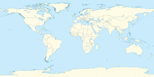
The meridian 99° west of Greenwich is a line of longitude that extends from the North Pole across the Arctic Ocean, North America, the Pacific Ocean, the Southern Ocean, and Antarctica to the South Pole.
The 99th meridian west forms a great circle with the 81st meridian east.
From Pole to Pole
[edit]Starting at the North Pole and heading south to the South Pole, the 99th meridian west passes through: