Maarssen: Difference between revisions
Content deleted Content added
No edit summary |
m Reverted edit by Thebestarticlemaker (talk) to last version by KittenKlub |
||
| (43 intermediate revisions by 30 users not shown) | |||
| Line 1: | Line 1: | ||
{{Infobox settlement |
{{Infobox settlement |
||
|official_name = Maarssen |
|official_name = Maarssen |
||
|image_skyline = Maarssen schippersgracht1.jpg |
|image_skyline = Maarssen schippersgracht1.jpg |
||
|image_flag = Flag of Maarssen.svg |
|image_flag = Flag of Maarssen.svg |
||
|flag_size = 120x100px |
|flag_size = 120x100px |
||
|image_shield |
|image_shield = Maarssen wapen.svg |
||
|shield_size = 100x80px |
|shield_size = 100x80px |
||
|image_map = Dutch Municipality Maarssen 2006.png |
|image_map = Dutch Municipality Maarssen 2006.png |
||
|mapsize = 250px |
|mapsize = 250px |
||
| ⚫ | |||
|coordinates_display = inline,title |
|||
| ⚫ | |||
|coordinates_region = NL |
|||
| ⚫ | |||
| ⚫ | |||
| ⚫ | |||
| ⚫ | |||
|subdivision_name2 = [[Stichtse Vecht]] |
|||
| ⚫ | |||
| ⚫ | |||
| ⚫ | |||
| ⚫ | |||
|leader_name = J.W. van der Sluijs |
|||
| ⚫ | |||
|leader_party = [[People's Party for Freedom and Democracy|VVD]] |
|||
| ⚫ | |||
| ⚫ | |||
| ⚫ | |||
| ⚫ | |||
| ⚫ | |||
| ⚫ | |||
|settlement_type = Town and former municipality |
|||
| ⚫ | |||
| ⚫ | |||
| ⚫ | |||
| ⚫ | |||
|settlement_type = Municipality |
|||
| ⚫ | |||
|population_density_km2 = 1447 |
|population_density_km2 = 1447 |
||
|timezone = [[Central European Time|CET]] |
|timezone = [[Central European Time|CET]] |
||
|utc_offset = +1 |
|utc_offset = +1 |
||
|timezone_DST = [[Central European Summer Time|CEST]] |
|timezone_DST = [[Central European Summer Time|CEST]] |
||
|utc_offset_DST = +2 |
|utc_offset_DST = +2 |
||
|coordinates = {{coord|52.135144|N|5.041297|E|region:NL|display=inline,title}} |
|||
|latd = 52.15 |
|||
| ⚫ | |||
|latNS = N |
|||
|longd = 5.05 |
|||
|longEW = E |
|||
| ⚫ | |||
}} |
}} |
||
'''Maarssen''' ({{ |
'''Maarssen''' ({{IPA-nl|ˈmaːrsə(n)|-|275 Maarssen.ogg}}) is a town in the middle of the [[Netherlands]], in the province of [[Utrecht (province)|Utrecht]], along the river [[Vecht (Utrecht)|Vecht]] and the [[Amsterdam–Rhine Canal]]. The west of Maarssen is called Maarssen-Broek<ref>Statistics are taken from the [http://www.sdu.nl/staatscourant/gemeentes/gem297u.htm SDU Staatscourant] {{webarchive|url=https://web.archive.org/web/20060219041429/http://www.sdu.nl/staatscourant/gemeentes/gem297u.htm |date=2006-02-19 }}</ref> whereas the east is called Maarssen-Dorp. Both put together and joined by other small towns around provide the area of Maarssen. |
||
On 1 January 2011 Maarssen merged with the councils of [[Breukelen]] and [[Loenen, Utrecht|Loenen]] to become [[Stichtse Vecht]]. |
|||
| ⚫ | |||
| ⚫ | |||
The municipality of Maarssen consists of the following cities, towns, villages and/or districts: Maarssen, [[Maarssenbroek]], [[Maarssen-dorp]], [[Maarsseveen]], [[Molenpolder]], [[Oud-Maarsseveen]], [[Oud-Zuilen]], [[Tienhoven (Maarssen)|Tienhoven]]. It is in an area called the "[[Vechtstreek]]". |
|||
The former municipality of Maarssen consisted of the following cities, towns, villages and/or districts: |
|||
* Maarssen (colloquially "Maarssen-dorp") and Maarssen-Broek |
|||
* [[Maarssenbroek]] |
|||
* [[Maarsseveen]] |
|||
* [[Molenpolder, Utrecht|Molenpolder]] |
|||
* [[Oud-Maarsseveen]] |
|||
* [[Oud-Zuilen]] |
|||
* [[Tienhoven, Stichtse Vecht|Tienhoven]] |
|||
==Transportation== |
== Transportation == |
||
| ⚫ | |||
| ⚫ | |||
== References == |
== References == |
||
{{Reflist}} |
|||
| ⚫ | |||
* Statistics are taken from the [http://www.sdu.nl/staatscourant/gemeentes/gem297u.htm SDU Staatscourant] |
|||
* {{Commonscatinline}} |
|||
* {{Official website|http://www.stichtsevecht.nl/}} |
|||
| ⚫ | |||
| ⚫ | |||
{{Dutch municipality Stichtse Vecht}} |
|||
| ⚫ | |||
{{Authority control}} |
|||
* [http://www.maarssen.nl/ Official website] |
|||
| ⚫ | |||
* [http://www.regiomaarssen.nl/ Regiomaarssen] |
|||
| ⚫ | |||
| ⚫ | |||
{{Commons|Maarssen}} |
|||
{{Utrecht Province}} |
|||
| ⚫ | |||
[[Category:Populated places in Utrecht (province)]] |
[[Category:Populated places in Utrecht (province)]] |
||
[[Category:Former municipalities of Utrecht (province)]] |
|||
[[Category:Stichtse Vecht]] |
|||
{{Utrecht-geo-stub}} |
{{Utrecht-geo-stub}} |
||
[[ca:Maarssen]] |
|||
[[de:Maarssen]] |
|||
[[eo:Maarssen]] |
|||
[[fr:Maarssen]] |
|||
[[fy:Maarssen]] |
|||
[[id:Maarssen]] |
|||
[[it:Maarssen]] |
|||
[[li:Maarssen]] |
|||
[[ms:Maarssen]] |
|||
[[nl:Maarssen]] |
|||
[[nds-nl:Meerssen]] |
|||
[[pl:Maarssen]] |
|||
[[ro:Maarssen]] |
|||
[[fi:Maarssen]] |
|||
[[sv:Maarssen]] |
|||
[[vi:Maarssen]] |
|||
[[vo:Maarssen]] |
|||
[[war:Maarssen]] |
|||
Latest revision as of 10:25, 2 April 2024
Maarssen | |
|---|---|
Town and former municipality | |
 | |
 Flag  Coat of arms | |
 | |
| Coordinates: 52°08′07″N 5°02′29″E / 52.135144°N 5.041297°E | |
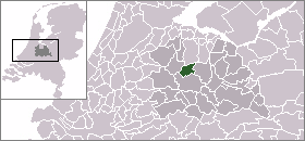
| Country | Netherlands |
| Province | Utrecht |
| Municipality | Stichtse Vecht |
| Area (2006) | |
| • Total | 30.86 km2 (11.92 sq mi) |
| • Land | 27.20 km2 (10.50 sq mi) |
| • Water | 3.66 km2 (1.41 sq mi) |
| Population (1 January 2007) | |
| • Total | 39,363 |
| • Density | 1,447/km2 (3,750/sq mi) |
| Source: CBS, Statline. | |
| Time zone | UTC+1 (CET) |
| • Summer (DST) | UTC+2 (CEST) |
| Website | www.stichtsevecht.nl |
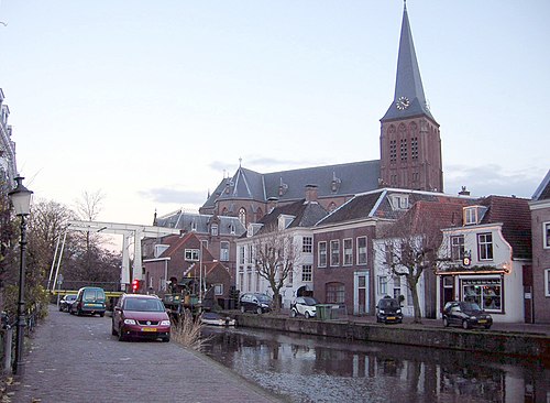
Maarssen (Dutch pronunciation: [ˈmaːrsə(n)] ) is a town in the middle of the Netherlands, in the province of Utrecht, along the river Vecht and the Amsterdam–Rhine Canal. The west of Maarssen is called Maarssen-Broek[1] whereas the east is called Maarssen-Dorp. Both put together and joined by other small towns around provide the area of Maarssen.
On 1 January 2011 Maarssen merged with the councils of Breukelen and Loenen to become Stichtse Vecht.
Population centres[edit]
The former municipality of Maarssen consisted of the following cities, towns, villages and/or districts:
- Maarssen (colloquially "Maarssen-dorp") and Maarssen-Broek
- Maarssenbroek
- Maarsseveen
- Molenpolder
- Oud-Maarsseveen
- Oud-Zuilen
- Tienhoven
Transportation[edit]
References[edit]
- ^ Statistics are taken from the SDU Staatscourant Archived 2006-02-19 at the Wayback Machine
External links[edit]
Media related to Maarssen at Wikimedia Commons
- Official website
- Historische Kring Maarssen
- Maarssen 2000
| International | |
|---|---|
| National | |
| Geographic | |
This Utrecht location article is a stub. You can help Wikipedia by expanding it. |