Ozarks: Difference between revisions
Snafflekid (talk | contribs) change cite style |
Snafflekid (talk | contribs) →Origin of the name: del citation |
||
| Line 9: | Line 9: | ||
==Origin of the name== |
==Origin of the name== |
||
Etymology of the name is a subject of speculation. |
Etymology of the name is a subject of speculation. |
||
"Ozarks" probably derives from a phonetic English spelling of the [[French language|French]] abbreviation "''aux Arks''", short for "''aux Arkansas''"<ref>[[George R. Stewart|Stewart, George R.]] (1967). ''Names on the Land: A Historical Account of Place-Naming in the United States'', p. 137. Houghton Mifflin, Boston.</ref> Originally referring to the [[trading post]] at [[Arkansas Post]] on the [[Mississippi River]], the term came to refer to the entire area drained by the [[Arkansas River|Arkansas]] and [[White River (Arkansas)|White]] rivers. (The origin of the name "Arkansas" itself is speculated.) Another possible derivation is "''aux arc''" meaning "to the arch" in reference to a massive [[natural bridge]] that forms an arch at Alum Cove in the [[Ozark-St. Francis National Forest]].{{Fact|date=February 2007}} This arch was used as a landmark. It is even suggested "''aux arcs''" is an abbreviation of "''aux arcs-en-ciel''", French for "to the rainbows" which are a common sight in the mountainous regions. After the [[Louisiana Purchase]], American travelers in the region referred to various features of the upland areas using the term "Ozark", such as "Ozark Mountains" and "Ozark forests". By the early [[20th Century]], "The Ozarks" had become a generic term.<ref>{{cite journal|last=Morrow|first=Lynn|title=Ozark/Ozarks: Establishing a Regional Term| journal=White River Valley Historical Quarterly| year=1996| volume=36| issue=2| accessdate=2006-09-08| url=http://thelibrary.springfield.missouri.org/lochist/periodicals/wrv/V36/N2/f96c.htm}} |
"Ozarks" probably derives from a phonetic English spelling of the [[French language|French]] abbreviation "''aux Arks''", short for "''aux Arkansas''"<ref>[[George R. Stewart|Stewart, George R.]] (1967). ''Names on the Land: A Historical Account of Place-Naming in the United States'', p. 137. Houghton Mifflin, Boston.</ref> Originally referring to the [[trading post]] at [[Arkansas Post]] on the [[Mississippi River]], the term came to refer to the entire area drained by the [[Arkansas River|Arkansas]] and [[White River (Arkansas)|White]] rivers. (The origin of the name "Arkansas" itself is speculated.) Another possible derivation is "''aux arc''" meaning "to the arch" in reference to a massive [[natural bridge]] that forms an arch at Alum Cove in the [[Ozark-St. Francis National Forest]].{{Fact|date=February 2007}} This arch was used as a landmark. It is even suggested "''aux arcs''" is an abbreviation of "''aux arcs-en-ciel''", French for "to the rainbows" which are a common sight in the mountainous regions. After the [[Louisiana Purchase]], American travelers in the region referred to various features of the upland areas using the term "Ozark", such as "Ozark Mountains" and "Ozark forests". By the early [[20th Century]], "The Ozarks" had become a generic term.<ref>{{cite journal|last=Morrow|first=Lynn|title=Ozark/Ozarks: Establishing a Regional Term| journal=White River Valley Historical Quarterly| year=1996| volume=36| issue=2| accessdate=2006-09-08| url=http://thelibrary.springfield.missouri.org/lochist/periodicals/wrv/V36/N2/f96c.htm}} |
||
Revision as of 18:28, 20 April 2007

The Ozarks (also referred to as Ozarks Mountain Country, the Ozark Mountains or the Ozark Plateau) is a physiographic, geologic, and cultural highland region of the central United States. It covers much of the southern half of Missouri and an extensive portion of northwest and north central Arkansas. The region also extends westward into extreme southeast Kansas and northeastern Oklahoma.
Although sometimes referred to as the Ozark Mountains, the region is a high and deeply dissected plateau. Geologically, the area is a broad dome around the Saint Francois Mountains. The Ozark Highlands area, the Ouachita Mountains of Arkansas and Oklahoma, and the Black Hills of South Dakota are the only major highland regions in the U.S. between the Appalachians and the Rocky Mountains. The Ozarks and Ouachitas are sometimes referred to collectively. For example, the ecoregion called Ozark Mountain Forests includes the Ouachita Mountains, although the Arkansas River valley and the Ouachitas, both south of the Boston Mountains, are not usually considered part of the Ozarks.
Origin of the name
Etymology of the name is a subject of speculation.
"Ozarks" probably derives from a phonetic English spelling of the French abbreviation "aux Arks", short for "aux Arkansas"[1] Originally referring to the trading post at Arkansas Post on the Mississippi River, the term came to refer to the entire area drained by the Arkansas and White rivers. (The origin of the name "Arkansas" itself is speculated.) Another possible derivation is "aux arc" meaning "to the arch" in reference to a massive natural bridge that forms an arch at Alum Cove in the Ozark-St. Francis National Forest.[citation needed] This arch was used as a landmark. It is even suggested "aux arcs" is an abbreviation of "aux arcs-en-ciel", French for "to the rainbows" which are a common sight in the mountainous regions. After the Louisiana Purchase, American travelers in the region referred to various features of the upland areas using the term "Ozark", such as "Ozark Mountains" and "Ozark forests". By the early 20th Century, "The Ozarks" had become a generic term.[2]
Geographic subdivisions
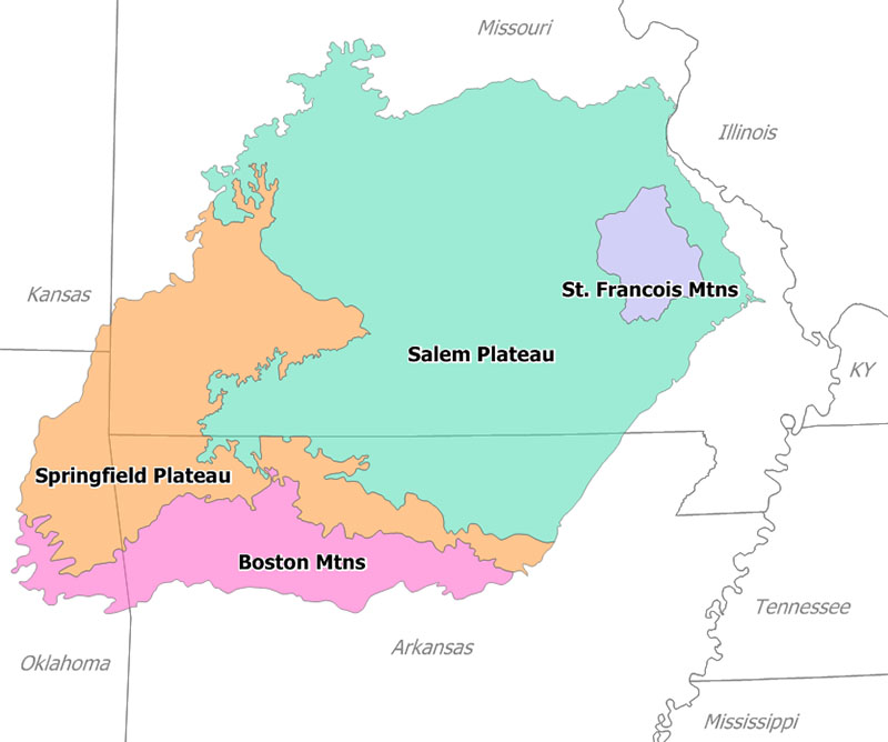
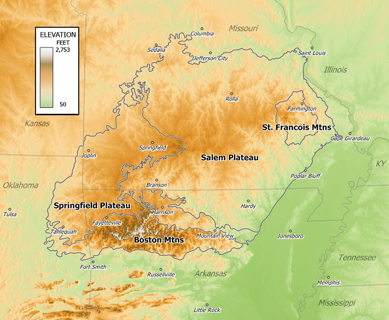
The Ozarks consist of four primary physiographic sections—the Springfield Plateau, the Salem Plateau, the Saint Francois Mountains, and the Boston Mountains. Topography is mostly gently rolling, except in the Boston Mountains, along the escarpments separating the Springfield and Salem Plateaus, and the Saint Francois Range where it is rugged. Karst features such as springs, sinkholes, and caves are common in the limestones of the Springfield Plateau and abundant in the dolostone bedrock of the Salem Plateau and Boston Mountains.
The Boston Mountains are the highest section of the Ozarks. Summits can reach elevations of just over 2,560 feet with valleys 500 to 1,550 feet deep. Turner Ward Knob (TWK) is the highest named peak. Located in western Newton County, Arkansas, its elevation is 2,463 feet. Nearby, five unnamed peaks have elevations at or slightly above 2,560 feet.
The Saint Francois Mountain Range rises above the Ozark Plateau and is the geological core of the highland dome. The igneous and volcanic rocks of the Saint Francois Mountains are the remains of a Precambrian mountain range. The core of the range existed as an island in the Paleozoic seas. Reef complexes occur in the sedimentary layers surrounding this ancient island. These flanking reefs were points of concentration for later ore-bearing fluids which formed the rich lead-zinc ores that have been and continue to be mined in the area. The igneous and volcanic rocks extend at depth under the relatively thin veneer of Paleozoic sedimentary rocks and form the basal crust of the entire region.
Regional economy of the Ozarks
Traditional economic activity
The Ozarks contain ore deposits of lead, zinc, iron, and barite. Many of these deposits have been depleted by historic mining activities, but much remains and is currently being mined in the lead belt of south-central Missouri. Historically the Old Lead Belt around the Saint Francois Mountains and the Tri-state district lead-zinc mining area around Joplin, Missouri have been very important sources of metals. Much of the area supports beef cattle ranching and dairy farming is common across the area. Oil exploration and extraction also takes place in the Oklahoma portion of the Ozarks. Logging of both softwood and hardwood timber species on both private land and in the National Forests has long been an important economic activity.
Growth industries
Tourism is the growth industry of the Ozarks as evidenced by the growth of the Branson, Missouri entertainment center. The Corps of Engineers lakes that were created by damming the White River in the mid 1950s have provided a large tourist, boating and fishing economy along the Missouri-Arkansas border. The Lake of the Ozarks and Truman Lake in the northern Ozarks were formed by damming the Osage River in 1931 and 1979 respectively. The Buffalo National River, created by an Act of Congress in 1972 as the Nation's first National River administered by the National Park Service, annually draws increasing numbers of canoeists, hikers, campers and cavers to northern Arkansas. In Missouri, the Ozark National Scenic Riverways, which while not officially a "national river," was the first US national park to be based on a river system, was establsihed in 1964 along the Current and Jacks Fork Rivers. Over 1.3 million visitors come to the Eminence and Van Buren areas as toursist drawn by this river park.
Poultry farming and food processing has also been on the rise, recently, in eastern Oklahoma and western Arkansas. The Tyson Foods corporation has food processing plants in western Arkansas; Stillwell foods has frozen vegetable and other food processing centers in eastern Oklahoma.
Logging and timber industries are also significant in the Ozark economy with operations ranging from small family run sawmills to large commercial concerns.
Ozark culture
Ozark also refers to a region of people with a distinct culture, architecture, and dialect shared by the people that live on the plateau. The people in this area have more in common with one another than with their surrounding states. Ozark culture is similar to that of Appalachia and the Upland South. Much of the population is of Scots-Irish descent, often including some Native American ancestry, and Ozark families tend to have lived in the area since the 19th century. Ozark religion tends to be conservative, or individualistic, with Assemblies of God, Southern Baptists, and other Protestant Pentecostal groups predominant. The Ozarks are also home to some sects unique to the area. Beyond a few communities settled by German Catholics and those areas (mostly Washington County) of original French settlement, Catholicism is rare outside of the cities. Homesteads in rural areas tend to be isolated instead of being clustered into villages. Early settlers relied on hunting, fishing and trapping to supplement their diets and incomes. Today hunting and fishing for recreation are common activities and an important part of the tourist industry. Foraging for mushrooms, especially morels, and for medicinal native plant species, including St. John's Wort and Ginseng, is common, and is financially supported by established buyers in the area. Where the Red Fern Grows is a book that takes place in the Ozark Mountain Area.
Other examples of the traditional nature of the Ozark culture would be the two major family theme parks in the region, Silver Dollar City and the now defunct Dogpatch U.S.A., both of which embrace rural, western, and 19th century life in the American midwest.

See also
- Green Country
- Arkansas River
- Buffalo National River
- United States physiographic regions
- List of U.S. multistate regions
- Ozark National Scenic Riverways
- Ozark Trail
- Ozark Highlands Trail
- Irish Wilderness
- Cookson Hills
References
- ^ Stewart, George R. (1967). Names on the Land: A Historical Account of Place-Naming in the United States, p. 137. Houghton Mifflin, Boston.
- ^ Morrow, Lynn (1996). "Ozark/Ozarks: Establishing a Regional Term". White River Valley Historical Quarterly. 36 (2). Retrieved 2006-09-08.
- McMillen, Margot Ford (1996) A to Z Missouri: The Dictionary of Missouri Place Names, Columbia, Missouri, Pebble Publishing, ISBN 0-9646625-4-X
- Rafferty, Milton D. (2001) The Ozarks: Land and Life, University of Arkansas Press, 2nd ed., ISBN 1-55728-714-7
- Unklesbay, A.G; & Vineyard, Jerry D. (1992) Missouri Geology — Three Billion Years of Volcanoes, Seas, Sediments, and Erosion, University of Missouri Press, ISBN 0-8262-0836-3
External links
- MO Conservation Ozarks Guide (broken link)
- Natural Divisions of Arkansas
- MO Conservation Natural Divisions Page
- Bryant Creek Watershed Atlas
- Shiloh Museum of Ozark History, Springdale, Arkansas
- Ozark Mountain Forests Ecoregion
- Ozark National Scenic Riverways