Beemster: Difference between revisions
→Local government: update |
|||
| Line 121: | Line 121: | ||
== Local government == |
== Local government == |
||
The municipal council of Beemster consists of 13 seats, which are divided as follows: |
The municipal council of Beemster consists of 13 seats, which are divided as follows since 2014: |
||
* Beemster Polder Partij - |
* Beemster Polder Partij - 4 seats |
||
* [[ |
* [[Democrats 66|D66]] - 3 seats |
||
* [[ |
* [[Labour Party (Netherlands)|PvdA]] - 2 seats |
||
* [[People's Party for Freedom and Democracy|VVD]] - 2 seats |
|||
* [[Christian Democratic Appeal|CDA]] - 2 seats |
* [[Christian Democratic Appeal|CDA]] - 2 seats |
||
Revision as of 15:34, 9 June 2015
Beemster | |
|---|---|
 Middenbeemster town centre | |
 Flag  Coat of arms | |
 Location in North Holland | |
| Country | Netherlands |
| Province | North Holland |
| Government | |
| • Body | Municipal council |
| • Mayor | Joyce van Beek (CDA) |
| Area | |
| • Total | 72.07 km2 (27.83 sq mi) |
| • Land | 70.58 km2 (27.25 sq mi) |
| • Water | 1.49 km2 (0.58 sq mi) |
| Elevation | −4 m (−13 ft) |
| Population (January 2021)[4] | |
| • Total | 10,110 |
| • Density | 143/km2 (370/sq mi) |
| Time zone | UTC+1 (CET) |
| • Summer (DST) | UTC+2 (CEST) |
| Postcode | 1460–1464 |
| Area code | 0299 |
| Website | www |
Beemster [ˈbeːmstər] is a municipality in the Netherlands, in the province of North Holland. Also, the Beemster is the first so-called polder in the Netherlands that was reclaimed from a lake, the water being extracted out of the lake by windmills. The Beemster Polder was dried during the period 1609 through 1612. It has preserved intact its well-ordered landscape of fields, roads, canals, dykes and settlements, laid out in accordance with classical and Renaissance planning principles. A grid of canals parallels the grid of roads in the Beemster. The grids are offset: the larger feeder canals are offset by approximately one kilometer from the larger roads.
Population centres
The municipality of Beemster consists of the following cities, towns, villages and/or districts: Middenbeemster, Noordbeemster, Westbeemster, Zuidoostbeemster.
Topography

Topographic map of the municipality of Beemster, 2013.
History
Around 800 AD the area of the modern municipality of Beemster was covered in peat. The name "Beemster" has been derived from "Bamestra" (see Groenedijk, 2000), the name of a small river in the area. In the period 1150-1250 peat-digging by people, and storm floods, enlarged that small river into an inland sea, a lake in open connection with the Zuiderzee. Around 1605 private investors started to drain the Beemster lake. In 1610, this was almost complete, but the lake re-filled because of a break in the Zuiderzee dikes. It was decided to make the ring-dike a meter high above the surrounding country. In 1612 the polder was dry and the country was divided among the investors. In the earlier days of the polder, farmers occupied its lands for growing the crops necessary for long sea journeys by the VOC to the East Indies. It turned out that the farmland was so good that the project was considered then to be an economic success, in contrast to e.g. the Heerhugowaard. Since 1999 the entire Beemster polder has been on the UNESCO world heritage list.
The Beemster polder is home to CONO Kaasmakers, maker of the Beemster brand of cheeses. This co-op was formed in 1901 to create cheese made from milk that comes from the Beemster polder. Today Beemster cheese[5] is sold in Europe, as well as the U.S., Canada, Japan, and China.
World Heritage Site
| UNESCO World Heritage Site | |
|---|---|
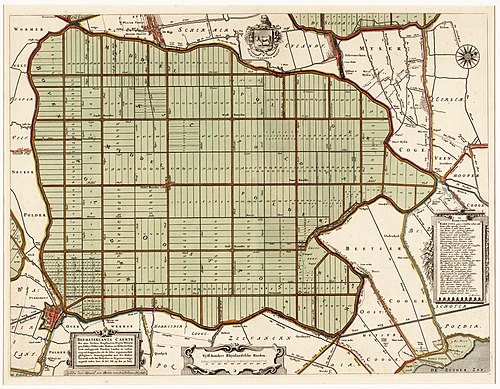 Beemster in 1658, clearly showing the regular grid pattern. | |
| Criteria | Cultural: i, ii, iv |
| Reference | 899 |
| Inscription | 1999 (23rd Session) |
Because of its historical relevance, and because the original structure of the area is still largely intact, the Beemster was inscribed on the UNESCO World Heritage Site list in 1999. Justification for Inscription is as follows:
- Criterion (i): The Beemster Polder is a masterpiece of creative planning, in which the ideals of antiquity and the Renaissance were applied to the design of a reclaimed landscape.
- Criterion (ii): The innovative and intellectually imaginative landscape of the Beemster Polder had a profound and lasting impact on reclamation projects in Europe and beyond.
- Criterion (iv): The creation of the Beemster Polder marks a major step forward in the interrelationship between humankind and water at a crucial period of social and economic expansion.
Local government
The municipal council of Beemster consists of 13 seats, which are divided as follows since 2014:
Mayor is Joyce van Beek (CDA).
References
Footnotes
- ^ "Harry Brinkman" (in Dutch). Gemeente Beemster. Retrieved 20 February 2014.
{{cite web}}: Cite has empty unknown parameter:|trans_title=(help) - ^ "Kerncijfers wijken en buurten 2020" [Key figures for neighbourhoods 2020]. StatLine (in Dutch). CBS. 24 July 2020. Retrieved 19 September 2020.
- ^ "Postcodetool for 1462NV". Actueel Hoogtebestand Nederland (in Dutch). Het Waterschapshuis. Retrieved 20 February 2014.
{{cite web}}: Cite has empty unknown parameter:|trans_title=(help) - ^ "Bevolkingsontwikkeling; regio per maand" [Population growth; regions per month]. CBS Statline (in Dutch). CBS. 1 January 2021. Retrieved 2 January 2022.
- ^ www.beemstercheese.us
Bibliography
- Van de Ven, G. (redactie) (1996). "Leefbaar laagland" (4th, revised reprint). Uitgeverij Matrijs. p. 33-35, 55 en 131-136.
- Groenedijk, T. (2000). "Nederlandse plaatsnamen". Slingenberg Boekproducties, Hoogeveen, Netherlands 2000.
External links
Media related to Beemster at Wikimedia Commons
- Official website
Places adjacent to Beemster | |
|---|---|

