Ben Klibreck: Difference between revisions
m clean up- spelling "et al." using AWB |
→top: sd Tags: Mobile edit Mobile app edit Android app edit |
||
| (26 intermediate revisions by 22 users not shown) | |||
| Line 1: | Line 1: | ||
{{Use dmy dates|date=April 2022}} |
|||
| ⚫ | |||
{{short description|Mountain in Scotland}} |
|||
| ⚫ | |||
| ⚫ | |||
| Photo = Ben Klibreck.jpg |
|||
| |
| name = Ben Klibreck |
||
| native_name ={{native name|gd|Beinn Clìbric}} |
|||
| Elevation = 962 m (3165 ft) |
|||
| ⚫ | |||
| ⚫ | |||
| photo_caption = Ben Klibreck from [[Strath Vagastie]] |
|||
| Range = |
|||
| elevation_m = 962 |
|||
| ⚫ | |||
| elevation_ref = <ref>{{cite web |url=http://www.walkhighlands.co.uk/munros/ben-klibreck |title= walkhighlands Ben Klibreck|author=<!--Staff writer(s); no by-line.--> |year=2014 |publisher=walkhighlands.co.uk |access-date=1 March 2014}}</ref> |
|||
| ⚫ | |||
| prominence_m = 818 |
|||
| ⚫ | |||
| ⚫ | |||
| First ascent = |
|||
| ⚫ | |||
| Easiest route = |
|||
| ⚫ | |||
| ⚫ | |||
| ⚫ | |||
| ⚫ | |||
| pronunciation = {{IPA-gd|peɲ ˈkʰliːpɾʲɪkʲ|lang}} |
|||
| ⚫ | |||
| ⚫ | |||
| Language = [[Scottish Gaelic language|Gaelic]] |
|||
| range = [[Northwest Highlands]] |
|||
| Pronunciation = peiɲ kleː pɾʲiçkʲ |
|||
| ⚫ | |||
| ⚫ | |||
| first_ascent = |
|||
| easiest_route = |
|||
}} |
}} |
||
'''Ben Klibreck''' ([ |
'''Ben Klibreck''' ({{lang-gd|Beinn Clìbric}})<ref>[http://www.gaelicplacenames.org/databasedetails.php?id=730 Gaelic Place-Names of Scotland]</ref> is a [[Scotland|Scottish]] [[mountain]] located in central [[Sutherland]]. It is an isolated mountain, rising above a large area of [[moorland]]. The highest point, '''Meall nan Con''' (the mound of the dogs), rises to {{convert|962|m|ft}} elevation and is therefore the second most northerly [[Munro]] after [[Ben Hope]].<ref name="Bennett">The Munros (SMC Guide), Donald Bennett et al., {{ISBN|0-907521-13-4}}</ref> The western side of the hill is a fairly uniform steep, [[Calluna|heathery]] slope, while the eastern side has a series of large, grassy [[Cirque|corries]] and has been described as having more character.<ref name="McNeish">''The Munros: Scotland's Highest Mountains'', Cameron McNeish, {{ISBN|0-947782-50-8}}</ref> |
||
Numerous ascents of Ben Klibreck are possible. It can be climbed from [[Crask]] to the south or [[Altnaharra]] to the north, but the easiest and most popular route is from the [[A836 road|A836]] to the west, by way of [[Loch nan Uan]] and up steep slopes to the summit ridge, which is then followed to the summit.<ref name="Bennett"/> |
Numerous ascents of Ben Klibreck are possible. It can be climbed from [[Crask]] to the south or [[Altnaharra]] to the north, but the easiest and most popular route is from the [[A836 road|A836]] to the west, by way of [[Loch nan Uan]] and up steep slopes to the summit ridge, which is then followed to the summit.<ref name="Bennett"/> |
||
| Line 24: | Line 28: | ||
== References == |
== References == |
||
<references /> |
<references /> |
||
{{British hills}} |
|||
{{Scottish Munros section 16}} |
{{Scottish Munros section 16}} |
||
| Line 32: | Line 36: | ||
[[Category:Marilyns of Scotland]] |
[[Category:Marilyns of Scotland]] |
||
[[Category:Mountains and hills of the Northwest Highlands]] |
[[Category:Mountains and hills of the Northwest Highlands]] |
||
[[Category:Mountains and hills of Highland (council area)]] |
|||
Latest revision as of 06:40, 23 December 2023
| Ben Klibreck | |
|---|---|
 Ben Klibreck from Strath Vagastie | |
| Highest point | |
| Elevation | 962 m (3,156 ft)[1] |
| Prominence | 818 m (2,684 ft)Ranked 32nd in British Isles |
| Parent peak | Ben More Assynt |
| Listing | Munro, Marilyn |
| Naming | |
| Native name | Beinn Clìbric (Scottish Gaelic) |
| English translation | "hill of the speckled cliff" |
| Pronunciation | Scottish Gaelic: [peɲ ˈkʰliːpɾʲɪkʲ] |
| Geography | |
| Location | Highland, Scotland |
| Parent range | Northwest Highlands |
| OS grid | NC585299 |
| Topo map | OS Landranger 16, OS Explorer 443 |
Ben Klibreck (Scottish Gaelic: Beinn Clìbric)[2] is a Scottish mountain located in central Sutherland. It is an isolated mountain, rising above a large area of moorland. The highest point, Meall nan Con (the mound of the dogs), rises to 962 metres (3,156 ft) elevation and is therefore the second most northerly Munro after Ben Hope.[3] The western side of the hill is a fairly uniform steep, heathery slope, while the eastern side has a series of large, grassy corries and has been described as having more character.[4]
Numerous ascents of Ben Klibreck are possible. It can be climbed from Crask to the south or Altnaharra to the north, but the easiest and most popular route is from the A836 to the west, by way of Loch nan Uan and up steep slopes to the summit ridge, which is then followed to the summit.[3]
References[edit]
- ^ "walkhighlands Ben Klibreck". walkhighlands.co.uk. 2014. Retrieved 1 March 2014.
- ^ Gaelic Place-Names of Scotland
- ^ a b The Munros (SMC Guide), Donald Bennett et al., ISBN 0-907521-13-4
- ^ The Munros: Scotland's Highest Mountains, Cameron McNeish, ISBN 0-947782-50-8
| Northern Highlands (20) | 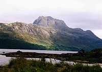   | |
|---|---|---|
| Western Highlands (20) | ||
| Central and Eastern Highlands (13) | ||
| Southern Highlands (15) | ||
| Islands (13) | ||
| Scottish Lowlands, England and Wales (13) | ||
| Republic of Ireland, Northern Ireland (25) | ||
 |  | ||