Brazlândia: Difference between revisions
Content deleted Content added
+ |
Do not repeat existing links in the text in See Also |
||
| Line 68: | Line 68: | ||
==See also== |
==See also== |
||
*[[Brasília]] |
|||
*[[Federal District (Brazil)|Federal District]] |
|||
*[[List of administrative regions of the Federal District (Brazil)|List of administrative regions of the Federal District]] |
*[[List of administrative regions of the Federal District (Brazil)|List of administrative regions of the Federal District]] |
||
Revision as of 00:02, 5 September 2017
This article includes a list of general references, but it lacks sufficient corresponding inline citations. (July 2013) |
Brazlândia | |
|---|---|
| Região Administrativa de Brazlândia Administrative Region of Brazlândia | |
 Flag | |
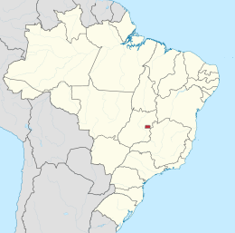
 Localization of Brazlândia in Federal District | |
| Country | |
| Region | Central-West |
| State | |
| Founded | December 10, 1964 |
| Government | |
| • Regional administrator | José Bolivar da Rocha Cruz Leite |
| Area | |
| • Total | 474.83 km2 (183.33 sq mi) |
| Population (2010)[1] | |
| • Total | 53.874 |
| Time zone | UTC-3 (UTC-3) |
| • Summer (DST) | UTC-2 (UTC-2) |
| Postal Code (CEP) | 72700-000 |
| Area code | +55 61 |
| Website | www.brazlandia.df.gov.br |
Brazlândia is an administrative region in the Federal District, Brazil.
See also
References
- ^ "Pesquisa Distrital por Amostra de Domicílios - 2010/2011" (PDF) (in Portuguese). Codeplan. Retrieved 2013-04-09.
External links
Wikimedia Commons has media related to Brazlândia.
15°41′S 48°12′W / 15.683°S 48.200°W
This Federal District, Brazil geography article is a stub. You can help Wikipedia by expanding it. |