Culham: Difference between revisions
Tom.Reding (talk | contribs) m Enum 1 author/editor WL; WP:GenFixes on |
→top: Parliament now having been dissolved, new boundaries are now in effect |
||
| (36 intermediate revisions by 11 users not shown) | |||
| Line 22: | Line 22: | ||
|postcode_area= OX |
|postcode_area= OX |
||
|dial_code= 01235 |
|dial_code= 01235 |
||
|constituency_westminster= [[ |
|constituency_westminster= [[Didcot and Wantage (UK Parliament constituency)|Didcot and Wantage]] |
||
|website= [http://www.culhamvillage.org.uk/ Culham Village, Oxfordshire] |
|website= [http://www.culhamvillage.org.uk/ Culham Village, Oxfordshire] |
||
}} |
}} |
||
| ⚫ | '''Culham''' is a village and [[Civil parishes in England|civil parish]] in a bend of the [[River Thames]], {{convert|1|mi}} south of [[Abingdon, Oxfordshire|Abingdon]] in [[Oxfordshire]]. The parish includes [[Culham Science Centre]] and Europa School UK (formerly the [[European School, Culham]], which was the only [[European Schools|Accredited European School]] within the United Kingdom). The parish is bounded by the Thames to the north, west and south, and by present and former field boundaries to the east. It is low-lying and fairly flat, rising from the Thames [[floodplain]] in the south to a north-facing [[escarpment]] in the north up to {{convert|80|m|disp=flip}} above sea level.<ref name=os>[http://getamap.ordnancesurvey.co.uk/getamap/frames.htm?mapAction=gaz&gazName=g&gazString=SU5095] [[Ordnance survey]] website</ref> The [[United Kingdom Census 2011|2011 Census]] recorded its population as 453.<ref>{{cite web |url= http://www.neighbourhood.statistics.gov.uk/dissemination/LeadKeyFigures.do?a=7&b=11122539&c=Culham&d=16&e=62&g=6459361&i=1001x1003x1032x1004&m=0&r=1&s=1438253752364&enc=1 |title=Area: Culham (Parish): Key Figures for 2011 Census: Key Statistics |work=[[Neighbourhood Statistics]] |publisher=[[Office for National Statistics]] |access-date=30 July 2015}}</ref> |
||
'''Culham''' is a village and [[Civil parishes in England|civil parish]] in a bend of the [[River Thames]], {{convert|1|mi}} south of [[Abingdon, Oxfordshire|Abingdon]] in [[Oxfordshire]]. |
|||
| ⚫ | The parish includes [[Culham Science Centre]] and Europa School UK, which |
||
The [[United Kingdom Census 2011|2011 Census]] recorded its population as 453.<ref>{{cite web |url= http://www.neighbourhood.statistics.gov.uk/dissemination/LeadKeyFigures.do?a=7&b=11122539&c=Culham&d=16&e=62&g=6459361&i=1001x1003x1032x1004&m=0&r=1&s=1438253752364&enc=1 |title=Area: Culham (Parish): Key Figures for 2011 Census: Key Statistics |work=[[Neighbourhood Statistics]] |publisher=[[Office for National Statistics]] |accessdate=30 July 2015}}</ref> |
|||
==Manor== |
==Manor== |
||
The [[Toponymy|toponym]] comes from the [[Old English]] ''Cula's hamm'', referring to the village's position in a bend of the Thames. Culham is known to have existed by the reign of King [[Coenwulf of Mercia]] early in the 9th century, by which time the [[manorialism|manor]] belonged to [[Abingdon Abbey]]. Soon after the [[Norman conquest of England]] part of the manor was seized by [[William I of England|William the Conqueror]], but the land was restored to the abbey and remained in its possession until the [[dissolution of the monasteries]] in 1538.<ref name=Lobel>Lobel, Mary 1962, pp. 27-39</ref> |
The [[Toponymy|toponym]] comes from the [[Old English]] ''Cula's hamm'', referring to the village's position in a bend of the Thames. Culham is known to have existed by the reign of King [[Coenwulf of Mercia]] early in the 9th century, by which time the [[manorialism|manor]] belonged to [[Abingdon Abbey]]. Soon after the [[Norman conquest of England]] part of the manor was seized by [[William I of England|William the Conqueror]], but the land was restored to the abbey and remained in its possession until the [[dissolution of the monasteries]] in 1538.<ref name=Lobel>Lobel, Mary 1962, pp. 27-39</ref> |
||
The west wing of Culham Manor was built in the 15th century as a [[medieval]] grange for [[Abingdon Abbey]]. It is [[Timber framing#The English tradition|half-timbered]], with a stone ground floor and timber-framed first floor. In 1610 it was extended with a new north front and east wing. The east wing was later demolished but the 17th |
The west wing of Culham Manor was built in the 15th century as a [[medieval]] grange for [[Abingdon Abbey]]. It is [[Timber framing#The English tradition|half-timbered]], with a stone ground floor and timber-framed first floor. In 1610 it was extended with a new north front and east wing. The east wing was later demolished but the 17th-century north front survives.<ref name=Lobel/> The house is a [[Listed building#Categories of listed building|Grade II* Listed building]].<ref>{{NHLE |num=1285637 |desc=Culham Manor |grade=II* |access-date=9 June 2013}}</ref> In 1685 a [[dovecote]] was built for the manor house. It, too, is now Grade II* listed.<ref>{{NHLE |num=1059793 |desc=Dovecote approximately 75 metres west of Culham Manor, the Green |grade=II* |fewer-links=yes |access-date=30 July 2015}}</ref> North of the house is a 17th-century sundial mounted on a 13th-century column.<ref>{{NHLE |num=1059793 |desc=Sundial approximately 30 metres north east of Culham Manor, the Green |grade=II |fewer-links=yes |access-date=30 July 2015}}</ref> |
||
In 1685 a [[dovecote]] was built for the manor house. It too is now Grade II* listed.<ref>{{NHLE |num=1059793 |desc=Dovecote approximately 75 metres west of Culham Manor, the Green |grade=II* |fewer-links=yes |accessdate=30 July 2015}}</ref> North of the house is a 17th-century sundial mounted on a 13th-century column.<ref>{{NHLE |num=1059793 |desc=Sundial approximately 30 metres north east of Culham Manor, the Green |grade=II |fewer-links=yes |accessdate=30 July 2015}}</ref> |
|||
==Parish church== |
==Parish church== |
||
Several records suggest that Culham may have had a chapel since the 9th century. A parish church dedicated to [[Saint Paul]] was built in the 12th century. It was [[Cruciform#Cruciform architectural plan|cruciform]], having a [[chancel]], [[nave]] and north and south [[transept]]s, and had features from the [[English Gothic architecture#Early English Gothic|Early English]] and [[English Gothic architecture#Decorated Gothic|Decorated]] periods. There was a [[Bell tower|tower]], and this was demolished and replaced in 1710. |
Several records suggest that Culham may have had a chapel since the 9th century. A parish church dedicated to [[Saint Paul]] was built in the 12th century. It was [[Cruciform#Cruciform architectural plan|cruciform]], having a [[chancel]], [[nave]] and north and south [[transept]]s, and had features from the [[English Gothic architecture#Early English Gothic|Early English]] and [[English Gothic architecture#Decorated Gothic|Decorated]] periods. There was a [[Bell tower|tower]], and this was demolished and replaced in 1710. In 1852 the whole church except the 1710 tower was demolished and replaced with a new [[Gothic Revival architecture|Gothic Revival]] building in 13th century style designed by [[Joseph Clarke (architect)|Joseph Clarke]].{{sfn|Sherwood|Pevsner|1974|p=565}}<ref>{{NHLE |num=1059792 |desc=Church of St Paul, The Green |grade=II |fewer-links=yes |access-date=30 July 2015}}</ref> |
||
During the rebuilding, [[Heraldry|heraldic]] [[stained glass]] installed in the north transept in 1638 was transferred to a window in the north aisle of the new church. The tower has a [[Change ringing|ring]] of six bells, but currently for technical reasons it is not possible to ring them. Mears and Stainbank of the [[Whitechapel Bell Foundry]] cast or re-cast five of the bells in 1921, and cast the present tenor bell in 1926. St Paul's also has a Sanctus bell cast in 1774 by Edne Witts of [[Aldbourne#Bell foundry|Aldbourne]], [[Wiltshire]].<ref>{{cite web |url= http://dove.cccbr.org.uk/detail.php?searchString=Culham&Submit=+Go+&DoveID=CULHAM |title=Culham S Paul |last=Walker |first=Mark |date=28 January 2009 |work=[[Dove's Guide for Church Bell Ringers]] |publisher=[[Central Council for Church Bell Ringers]] |access-date=30 July 2015}}</ref> St Paul's parish is now part of the [[Benefice#Church of England|Benefice]] of [[Dorchester Abbey|Dorchester]].<ref>{{cite web |url=http://www.achurchnearyou.com/benefice.php?B=27/153BJ |title=Benefice of Dorchester |author=Archbishops' Council |author-link=Archbishops' Council |work=[[A Church Near You]] |publisher=[[Church of England]] |access-date=30 July 2015 |archive-url=https://web.archive.org/web/20160304202422/http://www.achurchnearyou.com/benefice.php?B=27%2F153BJ |archive-date=4 March 2016 |url-status=dead }}</ref> |
|||
| ⚫ | In 1486 brothers Sir Humphrey and Thomas Stafford sought sanctuary in the church after they had fled from the newly crowned [[King Henry VII]] after the brothers were defeated at the [[Battle of Bosworth]]. On 14 May 1486, sixty of the King's men entered the church and arrested the two brothers who were tried for treason. Sir Humphrey Stafford was executed; however, Henry pardoned the younger brother Thomas.{{citation needed|date=September 2021}} Culham House is a mid-18th-century brick [[Georgian architecture|Georgian]] house, built to replace an earlier [[rectory]]. It was probably designed and built by [[John Phillips (c 1709-1775)|John Phillips]] of London.<ref>{{NHLE |num=1194530 |desc=Culham House, High Street |grade=II |fewer-links=yes |access-date=30 July 2015}}</ref> |
||
St Paul's parish is now part of the [[Benefice#Church of England|Benefice]] of [[Dorchester Abbey|Dorchester]].<ref>{{cite web |url=http://www.achurchnearyou.com/benefice.php?B=27/153BJ |title=Benefice of Dorchester |author=Archbishops' Council |author-link=Archbishops' Council |work=[[A Church Near You]] |publisher=[[Church of England]] |accessdate=30 July 2015 |archive-url=https://web.archive.org/web/20160304202422/http://www.achurchnearyou.com/benefice.php?B=27%2F153BJ |archive-date=4 March 2016 |url-status=dead }}</ref> |
|||
| ⚫ | Culham House is a mid-18th-century brick [[Georgian architecture|Georgian]] house, built to replace an earlier [[rectory]]. It was probably designed and built by [[John Phillips (c 1709-1775)|John Phillips]] of London.<ref>{{NHLE |num=1194530 |desc=Culham House, High Street |grade=II |fewer-links=yes | |
||
==Economic and social history== |
==Economic and social history== |
||
[[File:Old Culham Bridge - geograph.org.uk - 940811.jpg|thumb|Culham Old Bridge]] |
[[File:Old Culham Bridge - geograph.org.uk - 940811.jpg|thumb|Culham Old Bridge]] |
||
In 1416–22 the Abingdon Guild of the [[Canons Regular of the Order of the Holy Cross|Holy Cross]] built [[Culham Bridge]] over the narrow Back Water between the village and Abingdon to carry the main road between Abingdon and [[Dorchester, Oxfordshire|Dorchester]].<ref name=Lobel/> |
|||
| ⚫ | In the [[English Civil War]], [[Cavalier|Royalist]] forces encamped on Culham Hill until June 1643, defending Culham Bridge. In May 1644 the Royalists withdrew from Abingdon and [[Roundhead|Parliamentarian]] forces took the bridge, from which they were able to intercept supplies to the Royalist headquarters in Oxford. In January 1645 a Royalist force tried to recapture the bridge and destroy it. The skirmish, known as the Battle of Culham Bridge, ended in a Parliamentarian victory and the Royalist commander [[Henry Gage (soldier)|Sir Henry Gage]] was mortally wounded.<ref name=Lobel/> |
||
| ⚫ | In 1736 the [[Parliament of the United Kingdom|Parliament]] passed the first of several [[Act of Parliament|Acts]] to turn the road into a [[Toll road|turnpike]]. It ceased to be a turnpike in the 1870s.<ref name=Lobel/> In 1922 the [[Department for Transport|Ministry of Transport]] classified it as the [[A415 road]]. In 1928 [[Oxfordshire County Council]] built a new bridge for the A415 beside the 15th-century one. The old bridge is now a Grade II* listed building.<ref>{{NHLE |num=1368838 |desc=Culham Old Bridge, the Burycroft |grade=II* |fewer-links=yes | |
||
Road traffic between Culham and [[Sutton Courtenay]] crossed the Thames via Culham Ferry until 1807, when Sutton Bridge was built. In 1809 the [[Thames Navigation Commission]]ers built the {{convert|3/4|mi}} long Culham Cut, a navigation that bypasses a difficult stretch of river past a [[watermill]] at Sutton Courtenay. Sutton Bridge was extended to span the cut, and [[Culham Lock]] was built on the cut just above the bridge.<ref name=Lobel/> |
|||
In 1795 Culham had at least three [[public house]]s: the Nag's Head, the Sow and Pigs (later called the White Lion, but closed in 2009) and the Waggon and Horses (closed in 2015). In 1846 the Railway Hotel was added next to Culham railway station {{convert|1|mi}} east of the village, and in 1894 a parish boundary change transferred the Nag's Head to Abingdon.<ref name=Lobel/> |
|||
[[File:Culham School - geograph.org.uk - 19930.jpg|thumb|Culham C of E primary school]] |
[[File:Culham School - geograph.org.uk - 19930.jpg|thumb|Culham C of E primary school]] |
||
| ⚫ | |||
Most of the parish was farmed in an [[open field system]] until 1810, when Parliament passed an [[Inclosure Acts|Inclosure Act]] for Culham.<ref name=Lobel/> |
|||
| ⚫ | In 1416–22 the Abingdon Guild of the [[Canons Regular of the Order of the Holy Cross|Holy Cross]] built [[Culham Bridge]] over the narrow Back Water between the village and Abingdon to carry the main road between Abingdon and [[Dorchester, Oxfordshire|Dorchester]].<ref name=Lobel/> In the [[English Civil War]], [[Cavalier|Royalist]] forces encamped on Culham Hill until June 1643, defending Culham Bridge. In May 1644 the Royalists withdrew from Abingdon and [[Roundhead|Parliamentarian]] forces took the bridge, from which they were able to intercept supplies to the Royalist headquarters in Oxford. In January 1645 a Royalist force tried to recapture the bridge and destroy it. The skirmish, known as the Battle of Culham Bridge, ended in a Parliamentarian victory and the Royalist commander [[Henry Gage (soldier)|Sir Henry Gage]] was mortally wounded.<ref name=Lobel/> Most of the parish was farmed in an [[open field system]] until 1810, when Parliament passed an [[Inclosure Acts|Inclosure Act]] for Culham.<ref name=Lobel/> In the late 19th or early 20th century Culham had a brickworks.{{sfn|Dodsworth|1976|p=351}} |
||
| ⚫ | In 1736 the [[Parliament of the United Kingdom|Parliament]] passed the first of several [[Act of Parliament|Acts]] to turn the road into a [[Toll road|turnpike]]. It ceased to be a turnpike in the 1870s.<ref name=Lobel/> In 1922 the [[Department for Transport|Ministry of Transport]] classified it as the [[A415 road]]. In 1928 [[Oxfordshire County Council]] built a new bridge for the A415 beside the 15th-century one. The old bridge is now a [[Grade II* listed building]].<ref>{{NHLE |num=1368838 |desc=Culham Old Bridge, the Burycroft |grade=II* |fewer-links=yes |access-date=30 July 2015}}</ref> Road traffic between Culham and [[Sutton Courtenay]] crossed the Thames via Culham Ferry until 1807, when Sutton Bridge was built. In 1809 the [[Thames Navigation Commission]]ers built the {{convert|3/4|mi}} long Culham Cut, a navigation that bypasses a difficult stretch of river past a [[watermill]] at Sutton Courtenay. Sutton Bridge was extended to span the cut, and [[Culham Lock]] was built on the cut just above the bridge.<ref name=Lobel/> |
||
In 1844 the [[Great Western Railway]] opened an extension from [[Didcot Parkway railway station|Didcot]] to [[Oxford railway station|Oxford]], passing through the eastern part of the parish. The GWR opened a station on the main road and called it [[Culham railway station|Culham]], although it is {{convert|1+1/2|mi}} east of the village, slightly nearer to [[Clifton Hampden]]. [[Isambard Kingdom Brunel]] designed the station building, and it has recently been restored by [[Network Rail]]. It is served by [[Great Western Railway (train operating company)|Great Western Railway]]. |
|||
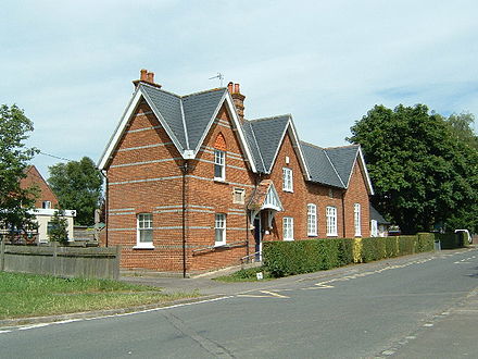
The village school was built in 1850 and reorganised as an infants' school in 1924. Oxfordshire's smallest primary school, it shares a headteacher with nearby Clifton Hampden CE Primary School and is threatened with closure.<ref name="school">{{cite news |url=https://www.oxfordmail.co.uk/news/17909513.official-closure-consultation-culham-primary-school/ |title=Official closure consultation for Culham primary school |first=Sophie |last=Grubb |newspaper=Oxford Mail |date=18 September 2019 | |
In 1844 the [[Great Western Railway]] opened an extension from [[Didcot Parkway railway station|Didcot]] to [[Oxford railway station|Oxford]], passing through the eastern part of the parish. The GWR opened a station on the main road and called it [[Culham railway station|Culham]], although it is {{convert|1+1/2|mi}} east of the village, slightly nearer to [[Clifton Hampden]]. [[Isambard Kingdom Brunel]] designed the station building, and it has recently been restored by [[Network Rail]]. It is served by [[Great Western Railway (train operating company)|Great Western Railway]]. In 1795 Culham had at least three [[public house]]s: the Nag's Head, the Sow and Pigs (later called the White Lion, but closed in 2009) and the Waggon and Horses (closed in 2015). In 1846 the Railway Hotel was added next to Culham railway station {{convert|1|mi}} east of the village, and in 1894 a parish boundary change transferred the Nag's Head to Abingdon.<ref name=Lobel/> The village school was built in 1850 and reorganised as an infants' school in 1924. Oxfordshire's smallest primary school, it shares a headteacher with nearby Clifton Hampden CE Primary School and is threatened with closure.<ref name="school">{{cite news |url=https://www.oxfordmail.co.uk/news/17909513.official-closure-consultation-culham-primary-school/ |title=Official closure consultation for Culham primary school |first=Sophie |last=Grubb |newspaper=Oxford Mail |date=18 September 2019 |access-date=3 June 2020}}</ref> |
||
In the late 19th or early 20th century Culham had a brickworks.{{sfn|Dodsworth|1976|p=351}} |
|||
==Europa School, UK== |
==Europa School, UK== |
||
In 1851 [[Samuel Wilberforce]], [[Bishop of Oxford]] founded the Diocesan Training College for Schoolmasters (Culham College). The building was designed by Joseph Clarke and completed in 1852. The building was altered and extended in about 1960.<ref>{{NHLE |num=1194452 |desc=Schola Europaea |grade=II |fewer-links=yes | |
In 1851 [[Samuel Wilberforce]], [[Bishop of Oxford]] founded the Diocesan Training College for Schoolmasters (Culham College). The building was designed by [[Joseph Clarke (architect)|Joseph Clarke]] and completed in 1852. The building was altered and extended in about 1960.<ref>{{NHLE |num=1194452 |desc=Schola Europaea |grade=II |fewer-links=yes |access-date=30 July 2015}}</ref> The college became Culham Institute,<ref>{{Cite web |url=http://www.culham.ac.uk/ |title=Culham Institute |access-date=19 January 2005 |archive-url=https://web.archive.org/web/20050207004736/http://www.culham.ac.uk/ |archive-date=7 February 2005 |url-status=dead }}</ref> a charitable research organisation associated with the [[Church of England]] housed in the Educational Studies Department of [[Oxford University]]. In 1978 the [[European School, Culham]] was founded in its former buildings before closing in 2017. Since 2012 the entire campus has gradually been subsumed by the [[Europa School UK]].<ref name="europa">{{cite web |url=http://www.europaschooluk.org |title=Home |publisher=Europa School UK |access-date=7 March 2020}}</ref> |
||
==Culham Science Centre== |
==Culham Science Centre== |
||
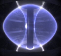
| ⚫ | In 1941<ref name=Lobel/> the [[Fleet Air Arm]] opened Royal Naval Air Station, [[RNAS Culham (HMS Hornbill)|HMS Hornbill]], between Culham railway station and Clifton Hampden village. Most of the airfield is in Clifton Hampden parish, but HMS Hornbill was also called RNAS Culham. A [[Royal Observer Corps Monitoring Post|Royal Observer Corps Post]] was also constructed, in a field east of Tollgate Road, adjacent to a pre existent [[Pillbox (military)|Pillbox]], just up the hill from the rifle range, next to the river.<ref>{{Cite news|url=http://www.28dayslater.co.uk/roc-post-culham-oxfordshire-30th-august-2011.t65261|title=Report - - ROC Post, Culham, Oxfordshire. 30th August, 2011.|newspaper=28DaysLater.co.uk|access-date=2016-12-03}}</ref> The [[British Admiralty|Admiralty]] closed the airfield in 1956<ref name=Lobel/> and transferred it to the [[United Kingdom Atomic Energy Authority|UK Atomic Energy Authority]] in 1960. The former airfield is now the [[Culham Science Centre]],<ref>[http://www.culham.org.uk/ Culham Science Centre]</ref> an 800,000 square metre scientific research site that most notably includes two major nuclear fusion experiments: [[Joint European Torus|JET]] and [[Mega Ampere Spherical Tokamak|MAST]].<ref>{{Cite web |url=http://www.ccfe.ac.uk/Tokamak.aspx |title=Culham Centre for Fusion Energy |access-date=16 November 2018 |archive-date=16 November 2018 |archive-url=https://web.archive.org/web/20181116220204/http://www.ccfe.ac.uk/Tokamak.aspx |url-status=dead }}</ref> The [[Small Tight Aspect Ratio Tokamak|START Nuclear Fusion Experiment]] was also conducted on the site until MAST succeeded it in 1999. |
||
| ⚫ | |||
| ⚫ | In 1941<ref name=Lobel/> the [[Fleet Air Arm]] opened Royal Naval Air Station, [[RNAS Culham (HMS Hornbill)|HMS Hornbill]], between Culham railway station and Clifton Hampden village. Most of the airfield is in Clifton Hampden parish, but HMS Hornbill was also called RNAS Culham. A [[Royal Observer Corps Monitoring Post|Royal Observer Corps Post]] was also constructed, in a field east of Tollgate Road, adjacent to a pre existent [[Pillbox (military)|Pillbox]], just up the hill from the rifle range, next to the river.<ref>{{Cite news|url=http://www.28dayslater.co.uk/roc-post-culham-oxfordshire-30th-august-2011.t65261|title=Report - - ROC Post, Culham, Oxfordshire. 30th August, 2011.|newspaper=28DaysLater.co.uk|access-date=2016-12-03}}</ref> |
||
The [[Admiralty]] closed the airfield in 1956<ref name=Lobel/> and transferred it to the [[United Kingdom Atomic Energy Authority|UK Atomic Energy Authority]] in 1960. The former airfield is now the Culham Science Centre,<ref>[http://www.culham.org.uk/ Culham Science Centre]</ref> an 800,000 square metre scientific research site that includes two nuclear fusion experiments: [[Joint European Torus|JET]] and [[Mega Ampere Spherical Tokamak|MAST]].<ref>[http://www.ccfe.ac.uk/Tokamak.aspx Culham Centre for Fusion Energy]</ref> The [[Small Tight Aspect Ratio Tokamak|START Nuclear Fusion Experiment]] was also conducted on the site until [[Mega Ampere Spherical Tokamak|MAST]] succeeded it in 1999. |
|||
==See also== |
==See also== |
||
| Line 86: | Line 64: | ||
==Sources== |
==Sources== |
||
*{{cite journal |last=Dodsworth |first=IC |year=1976 |title=The Chawley Brick and Tile Works, Cumnor |journal=Oxoniensia |volume=XLI |pages=348–353 |publisher=[[Oxfordshire Architectural and Historical Society]] |issn=0308-5562 |
*{{cite journal |last=Dodsworth |first=IC |year=1976 |title=The Chawley Brick and Tile Works, Cumnor |journal=Oxoniensia |volume=XLI |pages=348–353 |publisher=[[Oxfordshire Architectural and Historical Society]] |issn=0308-5562 }} |
||
*{{cite book |editor-last=Lobel |editor-first=Mary D |editor-link=Mary Lobel |year=1962 |title=A History of the County of Oxford |volume=7: Thame and Dorchester Hundreds |series=[[Victoria County History]] |place=London |publisher=[[Oxford University Press]] for the [[Institute of Historical Research]] |pages=27–39 |url= http://www.british-history.ac.uk/vch/oxon/vol7/pp27-39 |
*{{cite book |editor-last=Lobel |editor-first=Mary D |editor-link=Mary Lobel |year=1962 |title=A History of the County of Oxford |volume=7: Thame and Dorchester Hundreds |series=[[Victoria County History]] |place=London |publisher=[[Oxford University Press]] for the [[Institute of Historical Research]] |pages=27–39 |url= http://www.british-history.ac.uk/vch/oxon/vol7/pp27-39 }} |
||
*{{cite book |last1=Sherwood |first1=Jennifer |last2=Pevsner |first2=Nikolaus | |
*{{cite book |last1=Sherwood |first1=Jennifer |last2=Pevsner |first2=Nikolaus |author-link2=Nikolaus Pevsner |year=1974 |title=Oxfordshire |series=[[Pevsner Architectural Guides#Buildings of England|The Buildings of England]] |place=Harmondsworth |publisher=[[Penguin Books]] |isbn=0-14-071045-0 |pages=565–567 }} |
||
==External links== |
==External links== |
||
Latest revision as of 17:34, 28 May 2024
| Culham | |
|---|---|
 St Paul's parish church | |
 Culham Location within Oxfordshire | |
| Area | 8.29 km2 (3.20 sq mi) |
| Population | 453 (2011 Census) |
| • Density | 55/km2 (140/sq mi) |
| OS grid reference | SU5095 |
| Civil parish |
|
| District | |
| Shire county | |
| Region | |
| Country | England |
| Sovereign state | United Kingdom |
| Post town | Abingdon |
| Postcode district | OX14 |
| Dialling code | 01235 |
| Police | Thames Valley |
| Fire | Oxfordshire |
| Ambulance | South Central |
| UK Parliament | |
| Website | Culham Village, Oxfordshire |
Culham is a village and civil parish in a bend of the River Thames, 1 mile (1.6 km) south of Abingdon in Oxfordshire. The parish includes Culham Science Centre and Europa School UK (formerly the European School, Culham, which was the only Accredited European School within the United Kingdom). The parish is bounded by the Thames to the north, west and south, and by present and former field boundaries to the east. It is low-lying and fairly flat, rising from the Thames floodplain in the south to a north-facing escarpment in the north up to 260 feet (80 m) above sea level.[1] The 2011 Census recorded its population as 453.[2]
Manor
[edit]The toponym comes from the Old English Cula's hamm, referring to the village's position in a bend of the Thames. Culham is known to have existed by the reign of King Coenwulf of Mercia early in the 9th century, by which time the manor belonged to Abingdon Abbey. Soon after the Norman conquest of England part of the manor was seized by William the Conqueror, but the land was restored to the abbey and remained in its possession until the dissolution of the monasteries in 1538.[3]
The west wing of Culham Manor was built in the 15th century as a medieval grange for Abingdon Abbey. It is half-timbered, with a stone ground floor and timber-framed first floor. In 1610 it was extended with a new north front and east wing. The east wing was later demolished but the 17th-century north front survives.[3] The house is a Grade II* Listed building.[4] In 1685 a dovecote was built for the manor house. It, too, is now Grade II* listed.[5] North of the house is a 17th-century sundial mounted on a 13th-century column.[6]
Parish church
[edit]Several records suggest that Culham may have had a chapel since the 9th century. A parish church dedicated to Saint Paul was built in the 12th century. It was cruciform, having a chancel, nave and north and south transepts, and had features from the Early English and Decorated periods. There was a tower, and this was demolished and replaced in 1710. In 1852 the whole church except the 1710 tower was demolished and replaced with a new Gothic Revival building in 13th century style designed by Joseph Clarke.[7][8]
During the rebuilding, heraldic stained glass installed in the north transept in 1638 was transferred to a window in the north aisle of the new church. The tower has a ring of six bells, but currently for technical reasons it is not possible to ring them. Mears and Stainbank of the Whitechapel Bell Foundry cast or re-cast five of the bells in 1921, and cast the present tenor bell in 1926. St Paul's also has a Sanctus bell cast in 1774 by Edne Witts of Aldbourne, Wiltshire.[9] St Paul's parish is now part of the Benefice of Dorchester.[10]
In 1486 brothers Sir Humphrey and Thomas Stafford sought sanctuary in the church after they had fled from the newly crowned King Henry VII after the brothers were defeated at the Battle of Bosworth. On 14 May 1486, sixty of the King's men entered the church and arrested the two brothers who were tried for treason. Sir Humphrey Stafford was executed; however, Henry pardoned the younger brother Thomas.[citation needed] Culham House is a mid-18th-century brick Georgian house, built to replace an earlier rectory. It was probably designed and built by John Phillips of London.[11]
Economic and social history
[edit]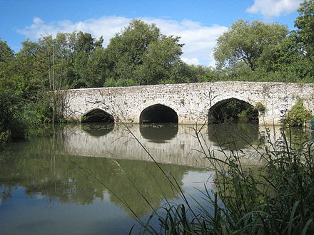
In 1416–22 the Abingdon Guild of the Holy Cross built Culham Bridge over the narrow Back Water between the village and Abingdon to carry the main road between Abingdon and Dorchester.[3] In the English Civil War, Royalist forces encamped on Culham Hill until June 1643, defending Culham Bridge. In May 1644 the Royalists withdrew from Abingdon and Parliamentarian forces took the bridge, from which they were able to intercept supplies to the Royalist headquarters in Oxford. In January 1645 a Royalist force tried to recapture the bridge and destroy it. The skirmish, known as the Battle of Culham Bridge, ended in a Parliamentarian victory and the Royalist commander Sir Henry Gage was mortally wounded.[3] Most of the parish was farmed in an open field system until 1810, when Parliament passed an Inclosure Act for Culham.[3] In the late 19th or early 20th century Culham had a brickworks.[12]
In 1736 the Parliament passed the first of several Acts to turn the road into a turnpike. It ceased to be a turnpike in the 1870s.[3] In 1922 the Ministry of Transport classified it as the A415 road. In 1928 Oxfordshire County Council built a new bridge for the A415 beside the 15th-century one. The old bridge is now a Grade II* listed building.[13] Road traffic between Culham and Sutton Courtenay crossed the Thames via Culham Ferry until 1807, when Sutton Bridge was built. In 1809 the Thames Navigation Commissioners built the 3⁄4 mile (1.2 km) long Culham Cut, a navigation that bypasses a difficult stretch of river past a watermill at Sutton Courtenay. Sutton Bridge was extended to span the cut, and Culham Lock was built on the cut just above the bridge.[3]
In 1844 the Great Western Railway opened an extension from Didcot to Oxford, passing through the eastern part of the parish. The GWR opened a station on the main road and called it Culham, although it is 1+1⁄2 miles (2.4 km) east of the village, slightly nearer to Clifton Hampden. Isambard Kingdom Brunel designed the station building, and it has recently been restored by Network Rail. It is served by Great Western Railway. In 1795 Culham had at least three public houses: the Nag's Head, the Sow and Pigs (later called the White Lion, but closed in 2009) and the Waggon and Horses (closed in 2015). In 1846 the Railway Hotel was added next to Culham railway station 1 mile (1.6 km) east of the village, and in 1894 a parish boundary change transferred the Nag's Head to Abingdon.[3] The village school was built in 1850 and reorganised as an infants' school in 1924. Oxfordshire's smallest primary school, it shares a headteacher with nearby Clifton Hampden CE Primary School and is threatened with closure.[14]
Europa School, UK
[edit]In 1851 Samuel Wilberforce, Bishop of Oxford founded the Diocesan Training College for Schoolmasters (Culham College). The building was designed by Joseph Clarke and completed in 1852. The building was altered and extended in about 1960.[15] The college became Culham Institute,[16] a charitable research organisation associated with the Church of England housed in the Educational Studies Department of Oxford University. In 1978 the European School, Culham was founded in its former buildings before closing in 2017. Since 2012 the entire campus has gradually been subsumed by the Europa School UK.[17]
Culham Science Centre
[edit]In 1941[3] the Fleet Air Arm opened Royal Naval Air Station, HMS Hornbill, between Culham railway station and Clifton Hampden village. Most of the airfield is in Clifton Hampden parish, but HMS Hornbill was also called RNAS Culham. A Royal Observer Corps Post was also constructed, in a field east of Tollgate Road, adjacent to a pre existent Pillbox, just up the hill from the rifle range, next to the river.[18] The Admiralty closed the airfield in 1956[3] and transferred it to the UK Atomic Energy Authority in 1960. The former airfield is now the Culham Science Centre,[19] an 800,000 square metre scientific research site that most notably includes two major nuclear fusion experiments: JET and MAST.[20] The START Nuclear Fusion Experiment was also conducted on the site until MAST succeeded it in 1999.
See also
[edit]References
[edit]- ^ [1] Ordnance survey website
- ^ "Area: Culham (Parish): Key Figures for 2011 Census: Key Statistics". Neighbourhood Statistics. Office for National Statistics. Retrieved 30 July 2015.
- ^ a b c d e f g h i j Lobel, Mary 1962, pp. 27-39
- ^ Historic England. "Culham Manor (Grade II*) (1285637)". National Heritage List for England. Retrieved 9 June 2013.
- ^ Historic England. "Dovecote approximately 75 metres west of Culham Manor, the Green (Grade II*) (1059793)". National Heritage List for England. Retrieved 30 July 2015.
- ^ Historic England. "Sundial approximately 30 metres north east of Culham Manor, the Green (Grade II) (1059793)". National Heritage List for England. Retrieved 30 July 2015.
- ^ Sherwood & Pevsner 1974, p. 565.
- ^ Historic England. "Church of St Paul, The Green (Grade II) (1059792)". National Heritage List for England. Retrieved 30 July 2015.
- ^ Walker, Mark (28 January 2009). "Culham S Paul". Dove's Guide for Church Bell Ringers. Central Council for Church Bell Ringers. Retrieved 30 July 2015.
- ^ Archbishops' Council. "Benefice of Dorchester". A Church Near You. Church of England. Archived from the original on 4 March 2016. Retrieved 30 July 2015.
- ^ Historic England. "Culham House, High Street (Grade II) (1194530)". National Heritage List for England. Retrieved 30 July 2015.
- ^ Dodsworth 1976, p. 351.
- ^ Historic England. "Culham Old Bridge, the Burycroft (Grade II*) (1368838)". National Heritage List for England. Retrieved 30 July 2015.
- ^ Grubb, Sophie (18 September 2019). "Official closure consultation for Culham primary school". Oxford Mail. Retrieved 3 June 2020.
- ^ Historic England. "Schola Europaea (Grade II) (1194452)". National Heritage List for England. Retrieved 30 July 2015.
- ^ "Culham Institute". Archived from the original on 7 February 2005. Retrieved 19 January 2005.
- ^ "Home". Europa School UK. Retrieved 7 March 2020.
- ^ "Report - - ROC Post, Culham, Oxfordshire. 30th August, 2011". 28DaysLater.co.uk. Retrieved 3 December 2016.
- ^ Culham Science Centre
- ^ "Culham Centre for Fusion Energy". Archived from the original on 16 November 2018. Retrieved 16 November 2018.
Sources
[edit]- Dodsworth, IC (1976). "The Chawley Brick and Tile Works, Cumnor". Oxoniensia. XLI. Oxfordshire Architectural and Historical Society: 348–353. ISSN 0308-5562.
- Lobel, Mary D, ed. (1962). A History of the County of Oxford. Victoria County History. Vol. 7: Thame and Dorchester Hundreds. London: Oxford University Press for the Institute of Historical Research. pp. 27–39.
- Sherwood, Jennifer; Pevsner, Nikolaus (1974). Oxfordshire. The Buildings of England. Harmondsworth: Penguin Books. pp. 565–567. ISBN 0-14-071045-0.
External links
[edit]
| International | |
|---|---|
| National | |