Devecser: Difference between revisions
m Repair duplicate template arguments |
No edit summary |
||
| Line 1: | Line 1: | ||
{{Infobox settlement <!--more fields are available for this Infobox--See Template:Infobox Settlement--> |
{{Infobox settlement <!--more fields are available for this Infobox--See Template:Infobox Settlement--> |
||
|settlement_type = [[List of cities and towns of Hungary|Town]] |
|||
|image_skyline = Devecser - Palace.jpg |
|image_skyline = Devecser - Palace.jpg |
||
|image_caption= Aerial photography: Devecser - Palace |
|image_caption= Aerial photography: Devecser - Palace |
||
|image_shield = Devecser |
|image_shield = Devecser címere.jpg |
||
|subdivision_type = [[Countries of the world|Country]] |
|subdivision_type = [[Countries of the world|Country]] |
||
|subdivision_name = {{HUN}} |
|subdivision_name = {{HUN}} |
||
| Line 12: | Line 13: | ||
|pushpin_label_position = <!-- the position of the pushpin label: left, right, top, bottom, none --> |
|pushpin_label_position = <!-- the position of the pushpin label: left, right, top, bottom, none --> |
||
|pushpin_map_caption =Location of Devecser |
|pushpin_map_caption =Location of Devecser |
||
|pushpin_mapsize = |
|pushpin_mapsize = |
||
| ⚫ | |||
| ⚫ | |||
| ⚫ | |||
| ⚫ | |||
| ⚫ | |||
| ⚫ | |||
| ⚫ | |||
|subdivision_type2=[[Districts of Hungary|District]] |
|||
| ⚫ | |||
|subdivision_name2=[[Devecser District|Devecser]] |
|||
area_total_km2=64.11 |
|area_total_km2=64.11 |
||
population_total=4330 |
|population_total=4330 |
||
| ⚫ | |||
|population_as_of=2015 |
|||
| ⚫ | |||
| ⚫ | |||
| ⚫ | |||
| ⚫ | |||
| ⚫ | |||
| ⚫ | |||
| ⚫ | |||
| ⚫ | |||
|area_code_type=[[Telephone numbers in Hungary|Area code]] |
|||
| ⚫ | |||
|website={{URL|http://www.devecser.hu/}} |
|||
|coordinates = {{coord|47.10637|17.43726|region:HU|display=inline,title}} |
|coordinates = {{coord|47.10637|17.43726|region:HU|display=inline,title}} |
||
}} |
}} |
||
'''Devecser''' ({{IPA-hu|ˈdɛvɛt͡ʃɛr}}) is a town in [[Veszprém County]], [[Hungary]]. |
'''Devecser''' ({{IPA-hu|ˈdɛvɛt͡ʃɛr}}) is a town in [[Veszprém County]], [[Hungary]]. |
||
| Line 48: | Line 52: | ||
{{-}} |
{{-}} |
||
== External links == |
|||
{{Commons category}} |
|||
* {{Official websitehttp://www.devecser.hu/}} in Hungarian |
|||
{{Devecser District}} |
|||
{{Veszprém}} |
{{Veszprém}} |
||
Revision as of 19:15, 9 January 2018
Devecser | |
|---|---|
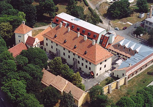 Aerial photography: Devecser - Palace | |
 Coat of arms | |
 Devecser Location of Devecser | |
| Coordinates: 47°06′23″N 17°26′14″E / 47.10637°N 17.43726°E | |
| Country | |
| County | Veszprém |
| District | Devecser |
| Area | |
| • Total | 64.11 km2 (24.75 sq mi) |
| Population (2015)[1] | |
| • Total | 4,330 |
| • Density | 68/km2 (170/sq mi) |
| Time zone | UTC+1 (CET) |
| • Summer (DST) | UTC+2 (CEST) |
| Postal code | 8460 |
| Area code | (+36) 88 |
| Website | www |
Devecser (Hungarian pronunciation: [ˈdɛvɛt͡ʃɛr]) is a town in Veszprém County, Hungary.
In the Middle Ages there were five villages in the area of today's Devecser: Devecser, Kisdevecser, Szék, Meggyes, and Patony. These villages expanded in the 12th and 13th century. There is an Esterházy castle in the town.
History

This section needs expansion. You can help by adding to it. (April 2013) |
While the Ottomans occupied most of central Europe, the region north of lake Balaton remained in the Kingdom of Hungary (1538–1867) (captaincy between Balaton and Drava). Until 1918, DEVECSER was part of the Austrian monarchy, province of Hungary;[2] in Transleithania after the compromise of 1867 in the Kingdom of Hungary.
Industrial accident
In October 2010, there was an industrial spill when a sludge reservoir at the Ajka aluminum plant burst its banks, killing at least four people and injuring more than 120.[3]
References
- ^ Gazetteer of Hungary, 1st January 2015. Hungarian Central Statistical Office.
- ^ Handbook of Austria and Lombardy-Venetia Cancellations on the Postage Stamp Issues 1850-1864, by Edwin MUELLER, 1961.
- ^ Dempsey, Judy (5 October 2010). "Industrial Sludge Floods Hungarian Towns". New York Times. Retrieved 5 October 2010.
External links
- Template:Official websitehttp://www.devecser.hu/ in Hungarian
| Town (1) |
| |
|---|---|---|
| Villages (27) | ||


| International | |
|---|---|
| National | |
This Veszprém county location article is a stub. You can help Wikipedia by expanding it. |