Feldthurns: Difference between revisions
No edit summary |
Mateus2019 (talk | contribs) and a village |
||
| (30 intermediate revisions by 19 users not shown) | |||
| Line 1: | Line 1: | ||
{{Infobox Italian comune |
{{Infobox Italian comune |
||
| name = Feldthurns |
| name = Feldthurns |
||
| official_name = Gemeinde Feldthurns<br>Comune di Velturno |
| official_name = Gemeinde Feldthurns<br/>Comune di Velturno |
||
| native_name = |
| native_name = |
||
| image_skyline = Schloss Veldthurns.jpg |
| image_skyline = Schloss Veldthurns.jpg |
||
| Line 12: | Line 12: | ||
| pushpin_label_position = |
| pushpin_label_position = |
||
| pushpin_map_alt = |
| pushpin_map_alt = |
||
| coordinates = {{coord|46|40|N|11|36|E|type:city(2,629)_region:IT|display=inline,title}} |
|||
| latd = 46 |latm = 40 |lats = |latNS = N |
|||
| longd = 11 |longm = 36 |longs = |longEW = E |
|||
| coordinates_type = type:city(2,629)_region:IT |
|||
| coordinates_display = title |
|||
| coordinates_footnotes = |
| coordinates_footnotes = |
||
| region = [[Trentino-Alto Adige/Südtirol]] |
| region = [[Trentino-Alto Adige/Südtirol]] |
||
| province = [[South Tyrol]] (BZ) |
| province = [[South Tyrol]] (BZ) |
||
| frazioni = Garn (Caerne), Schnauders (Snodres), Schrambach (San Pietro Mezzomonte), Tschiffnon ( |
| frazioni = Garn (Caerne), Schnauders (Snodres), Schrambach (San Pietro Mezzomonte), Tschiffnon (Giovignano) |
||
| mayor_party = |
| mayor_party = |
||
| mayor = Konrad Messner |
| mayor = Konrad Messner |
||
| Line 25: | Line 22: | ||
| area_total_km2 = 24.8 |
| area_total_km2 = 24.8 |
||
| population_total = 2740 |
| population_total = 2740 |
||
| population_as_of = |
| population_as_of = Jan. 2019 |
||
| population_footnotes = <ref name="istat">All demographics and other statistics: Italian statistical institute [[National Institute of Statistics (Italy)|Istat]].</ref> |
| population_footnotes = <ref name="istat">All demographics and other statistics: Italian statistical institute [[National Institute of Statistics (Italy)|Istat]].</ref> |
||
| pop_density_footnotes = |
| pop_density_footnotes = |
||
| population_demonym = German: Feldthurner<br>Italian: velturnesi |
| population_demonym = German: Feldthurner<br/>Italian: velturnesi |
||
| elevation_footnotes = |
| elevation_footnotes = |
||
| elevation_m = 851 |
| elevation_m = 851 |
||
| Line 41: | Line 38: | ||
}} |
}} |
||
'''Feldthurns''' ({{IPA-de|fɛlˈtʊrns}}; {{lang-it|Velturno}}) is a ''[[comune]]'' (municipality) in [[South Tyrol]] in northern [[Italy]] |
'''Feldthurns''' ({{IPA-de|fɛlˈtʊrns}}; {{lang-it|Velturno}} {{IPA-it|velˈturno|}}) is a ''[[comune]]'' (municipality) and a village in [[South Tyrol]] in northern [[Italy]] about {{convert|25|km|mi}} northeast of [[Bolzano]]. |
||
==Geography== |
==Geography== |
||
As of 30 |
As of 30 January 2019, it had a population of 2,873 and an area of {{convert|24.8|km2|mi2}}.<ref name="istat" /> |
||
Feldthurns borders |
Feldthurns borders [[Brixen]], [[Klausen, South Tyrol|Klausen]], [[Villnöß]] and [[Vahrn]]. |
||
===Frazioni=== |
===Frazioni=== |
||
The municipality of Feldthurns contains the ''[[frazione|frazioni]]'' (subdivisions, mainly villages and hamlets) Garn (Caerne), Schnauders (Snodres), Schrambach (San Pietro Mezzomonte), Tschiffnon ( |
The municipality of Feldthurns contains the ''[[frazione|frazioni]]'' (subdivisions, mainly villages and hamlets) Garn (Caerne), Schnauders (Snodres), Schrambach (San Pietro Mezzomonte), Tschiffnon (Giovignano). |
||
==History== |
==History== |
||
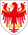
===Coat-of-arms=== |
===Coat-of-arms=== |
||
The emblem is party per [[fess]]: in the first part |
The emblem is party per [[fess]]: in the first part it's represented two embattled towers of [[gules]], the second is checky of [[gules]]. It's the [[canting arms]] used in 1607 in the castle by the Bishops of Brixen and symbolize the German name of the municipality: towers (''Thurn'') over the fields (''Feld''). The emblem was granted in 1966.<ref>{{Cite web |url=http://www.ngw.nl/int/ita/f/feldthur.htm |title=Heraldry of the World: Feldthurns |access-date=2011-06-25 |archive-url=https://web.archive.org/web/20120731174851/http://www.ngw.nl/int/ita/f/feldthur.htm |archive-date=2012-07-31 |url-status=dead }}</ref> |
||
===Notable residents=== |
|||
[[Ötzi the Iceman]] |
Isotopic analysis of [[Ötzi the Iceman]]'s tooth enamel suggests that he may have spent his childhood in present-day Feldthurns, circa 3275{{nbsp}}BCE.<ref>{{cite journal |last=Müller |first=Wolfgang |author2=Henry Fricke |author3=Alex N. Halliday |author-link3 = Alexander Halliday|author4=Malcolm T. McCulloch |author5=Jo-Anne Wartho |date=31 October 2003 |title=Origin and Migration of the Alpine Iceman |journal=[[Science (journal)|Science]] |volume=302 |issue=5646 |pages=862–866 |publisher=[[American Association for the Advancement of Science|AAAS]] |doi=10.1126/science.1089837 |pmid=14593178}} |
||
*{{cite web |title=Who was Ötzi the Iceman? |website=Mummy Tombs |url=http://www.mummytombs.com/otzi/identity.htm |archive-url=https://web.archive.org/web/20071217203826/http://www.mummytombs.com/otzi/identity.htm |archive-date=2007-12-17}}</ref> |
|||
==Society== |
==Society== |
||
===Linguistic distribution=== |
===Linguistic distribution=== |
||
According to the 2011 census, 98.33% of the population speak [[German language|German]], 0.91% [[Italian language|Italian]] and 0.76% [[Ladin language|Ladin]] as first language.<ref>{{cite journal |date=June 2012 |title=Volkszählung 2011/Censimento della popolazione 2011 |journal= |
According to the 2011 census, 98.33% of the population speak [[German language|German]], 0.91% [[Italian language|Italian]] and 0.76% [[Ladin language|Ladin]] as their first language.<ref>{{cite journal |date=June 2012 |title=Volkszählung 2011/Censimento della popolazione 2011 |journal=Astat Info |issue=38 |pages=6–7 |publisher=Provincial Statistics Institute of the Autonomous Province of South Tyrol|url=http://www.provinz.bz.it/astat/de/service/256.asp?news_action=300&news_image_id=563169 |access-date=2012-06-14 }}</ref> |
||
===Demographic evolution=== |
===Demographic evolution=== |
||
| Line 136: | Line 135: | ||
==References== |
==References== |
||
{{ |
{{Reflist}} |
||
==External links== |
==External links== |
||
* {{de |
* {{in lang|de|it}} [http://www.gemeinde.feldthurns.bz.it Homepage of the municipality] |
||
{{ |
{{Commons category-inline|Feldthurns}} |
||
{{ |
{{Clear}} |
||
{{South Tyrol}} |
{{South Tyrol}} |
||
{{Authority control}} |
{{Authority control}} |
||
[[Category:Municipalities of South Tyrol]] |
[[Category:Municipalities of South Tyrol]] |
||
Latest revision as of 11:39, 15 July 2023
Feldthurns | |
|---|---|
| Gemeinde Feldthurns Comune di Velturno | |
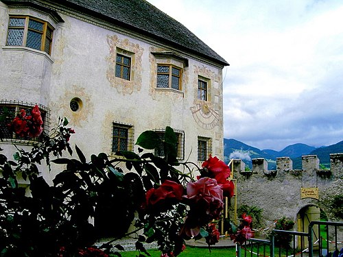 Velthurns Castle | |
Location of Feldthurns  | |
 Feldthurns Location of Feldthurns in Italy  Feldthurns Feldthurns (Trentino-Alto Adige/Südtirol) | |
| Coordinates: 46°40′N 11°36′E / 46.667°N 11.600°E | |
| Country | Italy |
| Region | Trentino-Alto Adige/Südtirol |
| Province | South Tyrol (BZ) |
| Frazioni | Garn (Caerne), Schnauders (Snodres), Schrambach (San Pietro Mezzomonte), Tschiffnon (Giovignano) |
| Government | |
| • Mayor | Konrad Messner |
| Area | |
| • Total | 24.8 km2 (9.6 sq mi) |
| Elevation | 851 m (2,792 ft) |
| Population (Jan. 2019)[2] | |
| • Total | 2,740 |
| • Density | 110/km2 (290/sq mi) |
| Demonym(s) | German: Feldthurner Italian: velturnesi |
| Time zone | UTC+1 (CET) |
| • Summer (DST) | UTC+2 (CEST) |
| Postal code | 39043 |
| Dialing code | 0472 |
| Patron saint | Maria |
| Website | Official website |
Feldthurns (German pronunciation: [fɛlˈtʊrns]; Italian: Velturno [velˈturno]) is a comune (municipality) and a village in South Tyrol in northern Italy about 25 kilometres (16 mi) northeast of Bolzano.
Geography[edit]
As of 30 January 2019, it had a population of 2,873 and an area of 24.8 square kilometres (9.6 sq mi).[2]
Feldthurns borders Brixen, Klausen, Villnöß and Vahrn.
Frazioni[edit]
The municipality of Feldthurns contains the frazioni (subdivisions, mainly villages and hamlets) Garn (Caerne), Schnauders (Snodres), Schrambach (San Pietro Mezzomonte), Tschiffnon (Giovignano).
History[edit]
Coat-of-arms[edit]
The emblem is party per fess: in the first part it's represented two embattled towers of gules, the second is checky of gules. It's the canting arms used in 1607 in the castle by the Bishops of Brixen and symbolize the German name of the municipality: towers (Thurn) over the fields (Feld). The emblem was granted in 1966.[3]
Notable residents[edit]
Isotopic analysis of Ötzi the Iceman's tooth enamel suggests that he may have spent his childhood in present-day Feldthurns, circa 3275 BCE.[4]
Society[edit]
Linguistic distribution[edit]
According to the 2011 census, 98.33% of the population speak German, 0.91% Italian and 0.76% Ladin as their first language.[5]
Demographic evolution[edit]
References[edit]
- ^ "Superficie di Comuni Province e Regioni italiane al 9 ottobre 2011". Italian National Institute of Statistics. Retrieved 16 March 2019.
- ^ a b All demographics and other statistics: Italian statistical institute Istat.
- ^ "Heraldry of the World: Feldthurns". Archived from the original on 2012-07-31. Retrieved 2011-06-25.
- ^ Müller, Wolfgang; Henry Fricke; Alex N. Halliday; Malcolm T. McCulloch; Jo-Anne Wartho (31 October 2003). "Origin and Migration of the Alpine Iceman". Science. 302 (5646). AAAS: 862–866. doi:10.1126/science.1089837. PMID 14593178.
- "Who was Ötzi the Iceman?". Mummy Tombs. Archived from the original on 2007-12-17.
- ^ "Volkszählung 2011/Censimento della popolazione 2011". Astat Info (38). Provincial Statistics Institute of the Autonomous Province of South Tyrol: 6–7. June 2012. Retrieved 2012-06-14.
External links[edit]
- (in German and Italian) Homepage of the municipality
Media related to Feldthurns at Wikimedia Commons
| International | |
|---|---|
| National | |