Kyōtanabe, Kyoto: Difference between revisions
+chapter |
m v2.05 - Fix errors for CW project (Spelling and typography - Missing end bold/italic) |
||
| (41 intermediate revisions by 27 users not shown) | |||
| Line 1: | Line 1: | ||
{{Infobox |
{{Infobox settlement |
||
| name |
| name = Kyōtanabe |
||
| official_name = |
|||
| JapaneseName = {{nobold|{{lang|ja|京田辺市}}}} |
|||
| native_name = {{nobold|{{nobold|{{lang|ja|京田辺市}}}}}} |
|||
| settlement_type = [[Cities of Japan|City]] |
|||
| native_name_lang = ja |
|||
| image_skyline = File:Kyotanabe Kyoto montage.JPG |
|||
| settlement_type = [[Cities of Japan|City]] |
|||
| image_caption = Top:A campus of Doshisha University, Middle left:Shuonan Temple, Middle right:Matsui Yamate Station, Bottom:Yamashiro Bridge |
|||
| other_name = |
|||
| image_flag = Flag of Kyotanabe Kyoto.JPG |
|||
<!-- images, nickname, motto --> |
|||
| image_symbol = Kyotanabe Kytoto chapter.JPG |
|||
| image_skyline = File:Kyotanabe Kyoto montage.JPG |
|||
| symbol_type = Chapter |
|||
| imagesize = |
|||
| image_map = Kyotanabe in Kyoto Prefecture Ja.svg |
|||
| image_caption = Top:A campus of Doshisha University, Middle left:Shuonan Temple, Middle right:Matsui Yamate Station, Bottom:Yamashiro Bridge |
|||
| coordinates = {{coord|34|49|N|135|46|E|region:JP|display=inline,title}} |
|||
| image_flag = Flag of Kyōtanabe, Kyoto.svg |
|||
| region = [[Kansai region|Kansai]] |
|||
| image_seal = Emblem of Kyōtanabe, Kyoto.svg |
|||
| prefecture = [[Kyoto Prefecture]] |
|||
| seal_type = Emblem |
|||
| district = |
|||
<!-- maps and coordinates --> |
|||
| mayor = Akezo Ishii (since April 2007) |
|||
| image_map= {{maplink|frame=yes|plain=yes|type=shape|stroke-width=2|stroke-color=#000000|zoom=8}} |
|||
| area_km2 = 42.94 |
|||
| image_map1 = Kyotanabe in Kyoto Prefecture Ja.svg |
|||
| population = 64,513 |
|||
| map_alt = |
|||
| population_as_of = January 1, 2012 |
|||
| map_caption = Location of Kyōtanabe in Kyoto Prefecture |
|||
| density_km2 = auto |
|||
| pushpin_map = Japan |
|||
| tree = [[Triadica sebifera]] |
|||
| pushpin_relief = |
|||
| flower = [[Azalea]] |
|||
| pushpin_map_caption = Location in Japan |
|||
| bird = |
|||
| coordinates = {{coord|34|48|52|N|135|46|04|E|region:JP|display=inline,title}} |
|||
| city_hall_address = Tanabe 80, Kyo-tanabe City, Kyoto Prefecture (京都府京田辺市田辺80番地) |
|||
| coordinates_footnotes = <!-- for references: use <ref> tags --> |
|||
| city_hall_postal_code = 610-0393 |
|||
<!-- location --> |
|||
| website = {{URL|http://www.kyotanabe.jp/}} |
|||
| subdivision_type = Country |
|||
| subdivision_name = Japan |
|||
| subdivision_type1 = [[List of regions of Japan|Region]] |
|||
| subdivision_name1 = [[Kansai region|Kansai]] |
|||
| subdivision_type2 = [[Prefectures of Japan|Prefecture]] |
|||
| subdivision_name2 = [[Kyoto Prefecture|Kyoto]] |
|||
| subdivision_type3 = [[Districts of Japan|District]] |
|||
| subdivision_name3 = |
|||
<!-- established --> |
|||
| established_title = |
|||
| established_date = |
|||
| established_title2 = |
|||
| established_date2 = |
|||
| extinct_title = Now part of |
|||
| extinct_date = |
|||
| founder = |
|||
| named_for = |
|||
<!-- seat, smaller parts --> |
|||
| seat_type = <!-- defaults to: Seat --> |
|||
| seat = |
|||
<!-- government type, leaders --> |
|||
| government_footnotes = <!-- for references: use <ref> tags --> |
|||
| leader_party = |
|||
| leader_title = Mayor |
|||
| leader_name = [[:ja:上村崇|Takashi Kamimura]] (since April 2019) |
|||
| leader_title1 = Vice Mayor |
|||
| leader_name1 = |
|||
<!-- display settings --> |
|||
| total_type = <!-- to set a non-standard label for total area and population rows --> |
|||
| unit_pref = Metric |
|||
<!-- area --> |
|||
| area_magnitude = <!-- use only to set a special wikilink --> |
|||
| area_footnotes = <!-- for references: use <ref> tags --> |
|||
| area_total_km2 = 42.92 |
|||
| area_land_km2 = |
|||
| area_water_km2 = |
|||
| area_water_percent = |
|||
| area_note = |
|||
<!-- elevation --> |
|||
| elevation_footnotes = <!-- for references: use <ref> tags --> |
|||
| elevation_m = |
|||
<!-- population --> |
|||
| population_footnotes = <!-- for references: use <ref> tags --> |
|||
| population_total = 71,757 |
|||
| population_as_of = September 1, 2023 |
|||
| population_density_km2 = auto |
|||
| population_est = |
|||
| pop_est_as_of = |
|||
<!-- time zone(s) --> |
|||
| timezone1 = [[Japan Standard Time|JST]] |
|||
| utc_offset1 = +09:00 |
|||
<!-- postal codes, area code --> |
|||
| postal_code_type = |
|||
| postal_code = |
|||
| area_code_type = <!-- defaults to: Area code(s) --> |
|||
| area_code = |
|||
<!-- blank fields (section 1) --> |
|||
| blank_name_sec1 = City hall address |
|||
| blank_info_sec1 = Tanabe 80, Kyōtanabe-shi, Kyoto-fu 610-0393 |
|||
<!-- blank fields (section 2) --> |
|||
| blank_name_sec2 = [[Köppen climate classification|Climate]] |
|||
| blank_info_sec2 = [[Humid subtropical climate|Cfa]] |
|||
<!-- website, footnotes --> |
|||
| website = {{Official|1=http://www.kyotanabe.jp/}} |
|||
| footnotes = |
|||
| module = {{Infobox place symbols| embedded=yes |
|||
| tree = [[Triadica sebifera]] |
|||
| flower = [[Rhododendron pulchrum]] |
|||
| bird = |
|||
| flowering_tree = |
|||
| butterfly = |
|||
| fish = |
|||
| other_symbols = |
|||
}} |
}} |
||
}} |
|||
[[File:Kyotanabe city center area Aerial photograph 2021.jpg|thumb|Aerial photograph of center area in 2021]] |
|||
{{nihongo|'''Kyōtanabe'''|京田辺市|Kyōtanabe-shi}} is a [[Cities of Japan|city]] located in the southern part of [[Kyoto Prefecture]], [[Japan]]. {{As of|2023|09|01}}, the city has an estimated [[population]] of 71,757 in 31555 households and a [[population density]] of 1700 persons per km<sup>2</sup>.<ref name="Kyōtanabe-hp">{{cite web |url=https://www.city.kyotanabe.lg.jp |title= Kyōtanabe City official statistics|location= Japan|language= ja}}</ref> The total area of the city is {{convert|42.92|sqkm|sqmi}}. |
|||
==Geography== |
|||
{{nihongo|'''Kyōtanabe'''|京田辺市|Kyōtanabe-shi}} is a [[Cities of Japan|city]] located in the southern tip of [[Kyoto Prefecture]], [[Japan]]. |
|||
Kyōtanabe is located in southern Kyoto Prefecture, bordered by Osaka Prefecture and Nara Prefecture. It is one of the three "Kansai Cultural and Academic Research City municipalities". The city is sandwiched between the [[Kizu River|Kizugawa River]], which runs north–south on the east side of the city, and the [[Mount Ikoma|Ikoma Mountains]] on the west. |
|||
===Neighboring municipalities=== |
|||
As of January 1, 2012, the city has an estimated [[population]] of 64,513, with 25,521 [[household]]s and a [[population density]] of 1,500 persons per km². The total area is 42.94 km². |
|||
;{{flagicon|Kyoto}} [[Kyoto Prefecture]] |
|||
*[[Yawata, Kyoto|Yawata]] |
|||
*[[Jōyō, Kyoto|Jōyō]] |
|||
*[[Kizugawa, Kyoto| Kizugawa]] |
|||
*[[Tsuzuki District, Kyoto| Tsuzuki District]] ([[Ide, Kyoto|Ide]]) |
|||
*[[Sōraku District, Kyoto|Sōraku District]] ([[Seika, Kyoto| Seika]]) |
|||
;{{flagicon|Osaka}} [[Osaka Prefecture]] |
|||
*[[Hirakata, Osaka|Hirakata]] |
|||
;{{flagicon|Nara}} [[Nara Prefecture]] |
|||
*[[Ikoma, Nara|Ikoma]] |
|||
== |
===Climate=== |
||
Kyōtanabe has a [[humid subtropical climate]] ([[Köppen climate classification|Köppen]] ''Cfa''), featuring a marked seasonal variation in temperature and precipitation. Summers are hot and humid, but winters are relatively cold with occasional snowfall. The average annual temperature in Kyōtanabe is {{convert|15.3|C}}. The average annual rainfall is {{cvt|1429.8|mm}} with June as the wettest month. The temperatures are highest on average in August, at around {{convert|27.5|C}}, and lowest in January, at around {{convert|4.1|C}}.<ref name ="normals"/> Its record high is {{cvt|39.0|C}}, reached on 16 August 2007, and its record low is {{cvt|-6.8|C}}, reached on 27 February 1981.<ref name = "extremes"/> |
|||
Kyōtanabe was briefly the [[capital of Japan]] during the reign of [[Emperor Keitai]]. The life of the Imperial court was centered at ''Tsutsuki'' Palace where the emperor lived in 511–518.<ref>Koch, W. (1904). [https://books.google.com/books?id=LZkCAAAAMAAJ&pg=PA13&dq=Hirotaka++no+miya&hl=en&sa=X&ei=qvShT_XcKMHZgQeghIHkCA&ved=0CF4Q6AEwCA#v=onepage&q=Hirotaka%20%20no%20miya&f=false ''Japan; Geschichte nach japanischen Quellen und ethnographische Skizzen. Mit einem Stammbaum des Kaisers von Japan,'' p. 13].</ref> |
|||
{{Weather box |
|||
The modern city was founded on April 1, 1997, after the town of '''Tanabe''' was reorganized into the city of Kyōtanabe. The Kyō- was added to distinguish it from the city of [[Tanabe, Wakayama]]. |
|||
|width=auto |
|||
|collapsed = Y |
|||
|single line = Y |
|||
|metric first = Y |
|||
|location = Kyōtanabe (1991−2020 normals, extremes 1978−present) |
|||
|Jan record high C = 17.6 |
|||
|Feb record high C = 22.4 |
|||
|Mar record high C = 25.9 |
|||
|Apr record high C = 30.6 |
|||
|May record high C = 33.5 |
|||
|Jun record high C = 37.5 |
|||
|Jul record high C = 38.5 |
|||
|Aug record high C = 39.0 |
|||
|Sep record high C = 37.0 |
|||
|Oct record high C = 32.7 |
|||
|Nov record high C = 26.5 |
|||
|Dec record high C = 23.3 |
|||
|Jan record low C = -6.6 |
|||
|Feb record low C = -6.8 |
|||
|Mar record low C = -4.1 |
|||
|Apr record low C = -2.1 |
|||
|May record low C = 0.2 |
|||
|Jun record low C = 6.7 |
|||
|Jul record low C = 13.8 |
|||
|Aug record low C = 14.5 |
|||
|Sep record low C = 9.1 |
|||
|Oct record low C = 2.6 |
|||
|Nov record low C = -1.8 |
|||
|Dec record low C = -5.1 |
|||
|Jan high C = 9.1 |
|||
|Feb high C = 10.0 |
|||
|Mar high C = 13.9 |
|||
|Apr high C = 19.9 |
|||
|May high C = 24.9 |
|||
|Jun high C = 28.0 |
|||
|Jul high C = 31.8 |
|||
|Aug high C = 33.4 |
|||
|Sep high C = 29.0 |
|||
|Oct high C = 23.2 |
|||
|Nov high C = 17.2 |
|||
|Dec high C = 11.6 |
|||
|Jan mean C = 4.1 |
|||
|Feb mean C = 4.6 |
|||
|Mar mean C = 8.0 |
|||
|Apr mean C = 13.5 |
|||
|May mean C = 18.6 |
|||
|Jun mean C = 22.6 |
|||
|Jul mean C = 26.5 |
|||
|Aug mean C = 27.5 |
|||
|Sep mean C = 23.4 |
|||
|Oct mean C = 17.4 |
|||
|Nov mean C = 11.3 |
|||
|Dec mean C = 6.2 |
|||
|Jan low C = -0.6 |
|||
|Feb low C = -0.4 |
|||
|Mar low C = 2.3 |
|||
|Apr low C = 7.2 |
|||
|May low C = 12.6 |
|||
|Jun low C = 18.0 |
|||
|Jul low C = 22.4 |
|||
|Aug low C = 23.0 |
|||
|Sep low C = 18.9 |
|||
|Oct low C = 12.4 |
|||
|Nov low C = 6.2 |
|||
|Dec low C = 1.4 |
|||
|precipitation colour = green |
|||
|Jan precipitation mm = 51.0 |
|||
|Feb precipitation mm = 63.4 |
|||
|Mar precipitation mm = 108.0 |
|||
|Apr precipitation mm = 106.8 |
|||
|May precipitation mm = 141.0 |
|||
|Jun precipitation mm = 204.2 |
|||
|Jul precipitation mm = 181.5 |
|||
|Aug precipitation mm = 152.3 |
|||
|Sep precipitation mm = 156.9 |
|||
|Oct precipitation mm = 140.0 |
|||
|Nov precipitation mm = 74.0 |
|||
|Dec precipitation mm = 56.9 |
|||
|year precipitation mm = 1429.8 |
|||
|unit precipitation days = 1.0 mm |
|||
|Jan precipitation days = 6.0 |
|||
|Feb precipitation days = 6.6 |
|||
|Mar precipitation days = 10.0 |
|||
|Apr precipitation days = 10.0 |
|||
|May precipitation days = 9.9 |
|||
|Jun precipitation days = 12.0 |
|||
|Jul precipitation days = 11.4 |
|||
|Aug precipitation days = 8.7 |
|||
|Sep precipitation days = 10.7 |
|||
|Oct precipitation days = 9.4 |
|||
|Nov precipitation days = 6.7 |
|||
|Dec precipitation days = 6.5 |
|||
|Jan sun = 130.5 |
|||
|Feb sun = 127.8 |
|||
|Mar sun = 167.2 |
|||
|Apr sun = 186.3 |
|||
|May sun = 201.9 |
|||
|Jun sun = 155.0 |
|||
|Jul sun = 170.9 |
|||
|Aug sun = 216.7 |
|||
|Sep sun = 163.3 |
|||
|Oct sun = 162.8 |
|||
|Nov sun = 141.4 |
|||
|Dec sun = 138.0 |
|||
|year sun = 1961.8 |
|||
|source 1 = [[Japan Meteorological Agency]]<ref name=extremes>{{cite web |
|||
| url = https://www.data.jma.go.jp/obd/stats/etrn/view/rank_a.php?prec_no=61&block_no=0598&year=&month=&day=&view=h0 |
|||
|script-title=ja:観測史上1~10位の値(年間を通じての値) |
|||
| publisher = [[Japan Meteorological Agency|JMA]] |
|||
| access-date = March 28, 2022}}</ref><ref name=normals>{{cite web |
|||
| url = https://www.data.jma.go.jp/obd/stats/etrn/view/nml_amd_ym.php?prec_no=61&block_no=0598&year=&month=&day=&view=h0 |
|||
|script-title=ja:気象庁 / 平年値(年・月ごとの値) |
|||
| publisher = [[Japan Meteorological Agency|JMA]] |
|||
| access-date = March 28, 2022}}</ref>}} |
|||
==Demographics== |
|||
In Kyoto born a singer and member of girl group [[Twice (band)|Twice]] [[ Momo Hirai]] |
|||
Per Japanese census data, the population of Kyōtanabe in 2020 is 73,753 people.<ref name=zensus/> Kyōtanabe's population has increased roughly sevenfold over the past century. The city has grown almost continuously since the census began in 1920, and saw especially rapid growth in the late 20th century. |
|||
{{Historical populations |
|||
| 1920 | 10,921 |
|||
| 1925 | 10,895 |
|||
| 1930 | 11,404 |
|||
| 1935 | 12,018 |
|||
| 1940 | 12,505 |
|||
| 1945 | 15,332 |
|||
| 1950 | 15,391 |
|||
| 1955 | 15,387 |
|||
| 1960 | 15,793 |
|||
| 1965 | 17,333 |
|||
| 1970 | 21,507 |
|||
| 1975 | 30,022 |
|||
| 1980 | 39,198 |
|||
| 1985 | 44,465 |
|||
| 1990 | 48,899 |
|||
| 1995 | 53,040 |
|||
| 2000 | 59,577 |
|||
| 2005 | 64,008 |
|||
| 2010 | 67,904 |
|||
| 2015 | 70,835 |
|||
| 2020 | 73,753 |
|||
|align = none |
|||
|cols = 2 |
|||
| footnote = Kyōtanabe population statistics<ref name=zensus>[https://www.citypopulation.de/en/japan/kyoto/ Kyōtanabe population statistics]</ref> |
|||
}} |
|||
== History == |
|||
The area of Kyōtanabe was part of ancient [[Yamashiro Province]]. Kyōtanabe was briefly the [[capital of Japan]] during the reign of the legendary [[Kofun period]] [[Emperor Keitai]]. The life of the Imperial court was centered at ''Tsutsuki'' Palace where the emperor lived in 511–518.<ref>Koch, W. (1904). [https://books.google.com/books?id=LZkCAAAAMAAJ&dq=Hirotaka++no+miya&pg=PA13 ''Japan; Geschichte nach japanischen Quellen und ethnographische Skizzen. Mit einem Stammbaum des Kaisers von Japan,'' p. 13].</ref>The village of Tanabe in [[Tsuzuki District, Kyoto]] was established on April 1, 1889 with the creation of the modern municipalities system and was elevated to town status on October 12, 1906. On April 1, 1997 Tanabe was elevated to city status, as the 12th city in Kyoto Prefecture after Yawata, and the 669th city in Japan. In order to avoid confusion with [[Tanabe, Wakayama]], the city was named "Kyōtanabe" by adding "Kyō" from Kyoto Prefecture. |
|||
==Government== |
|||
Kyōtanabe has a [[mayor-council]] form of government with a directly elected mayor and a [[unicameral]] city council of 20 members. Kyōtanabe, collectively with the municipalities of [[Tsuzuki District, Kyoto]] contributes two members to the Kyoto Prefectural Assembly. In terms of national politics, the city is part of the [[Kyoto 6th district]] of the [[House of Representatives of Japan|lower house]] of the [[Diet of Japan]]. |
|||
==Economy== |
|||
Kyōtanabe has a mixed economy based on commerce, agriculture and light manufacturing. [[Tsubakimoto Chain]], [[Dai Nippon Printing]] and [[Meiji (company)|Meiji)]] have major factories in the city. |
|||
==Education== |
|||
=== Colleges and universities === |
|||
* [[Doshisha Women's College of Liberal Arts]] |
|||
* [[Doshisha Women's Junior College]] |
|||
===Primary and secondary education=== |
|||
Kyōtanabe has nine public elementary schools and three public junior high schools operated by city government and one public high school operated by the Kyoto Prefectural Board of Education. There is also one private junior high and one private high school. |
|||
== Transportation == |
|||
===Railways=== |
|||
[[File:JR logo (west).svg|frameless|20x20px]] [[West Japan Railway Company|JR West]] - [[Katamachi Line|Katamachi Line (Gakkentoshi Line)]] |
|||
* {{STN|JR Miyamaki}} - {{STN|Dōshishamae}} - {{STN|Kyōtanabe}} - {{STN|Ōsumi}} - {{STN|Matsuiyamate}} |
|||
[[file:KintetsuLogo.svg|20px]] - [[Kintetsu Railway]] [[Kintetsu Kyoto Line|Kyoto Line]] |
|||
* {{STN|Shin-Tanabe}} - {{STN|Kōdo|Kyoto}} - {{STN|Miyamaki}} - {{STN|Kintetsu Miyazu}} |
|||
=== Highways === |
|||
* [[File:JP Expressway E1A.svg|25px|link=|alt=]] [[Shin-Meishin Expressway]] |
|||
* [[File:JP Expressway E89.svg|25px|link=|alt=]] [[Daini Keihan Expressway]] |
|||
* [[File:JP Expressway E24.svg|25px|link=|alt=]] [[Keinawa Expressway]] |
|||
* {{jct|country=JPN|Route|1}} |
|||
* {{jct|country=JPN|Route|24}} |
|||
* {{jct|country=JPN|Route|307}} |
|||
==Local attractions== |
|||
*[[Ōsumi Kurumazuka Kofun]], National Historic Site |
|||
==Notable people from Kyōtanabe== |
|||
* [[Kenji Takao]], [[running]] coach and former [[long-distance runner]] ([[10,000 metres]]) |
|||
* [[Takuya Muguruma]], former [[soccer player|football player]] |
|||
* [[Akinari Kawazura]], [[soccer player|football player]] ([[Omiya Ardija]], [[J2 League]]) |
|||
* [[Meg Hemphill]], [[track and field athlete]] |
|||
* [[Momo Hirai]], singer, dancer, model, [[MC]], member of South Korean girl group [[Twice]] |
|||
==References== |
==References== |
||
| Line 42: | Line 314: | ||
==External links== |
==External links== |
||
*{{Commons category-inline|Kyotanabe, Kyoto|Kyōtanabe, Kyoto}} |
*{{Commons category-inline|Kyotanabe, Kyoto|Kyōtanabe, Kyoto}} |
||
* [http://www.kyotanabe.jp/ Kyotanabe City official website] {{ |
* [http://www.kyotanabe.jp/ Kyotanabe City official website] {{in lang|ja}} |
||
* [http://www.kyotanabe.jp/category/7-0-0-0-0.html Kyotanabe City official website] {{ |
* [http://www.kyotanabe.jp/category/7-0-0-0-0.html Kyotanabe City official website] {{Webarchive|url=https://web.archive.org/web/20120512080923/http://www.kyotanabe.jp/category/7-0-0-0-0.html |date=2012-05-12 }} {{in lang|en}} |
||
{{Kyoto}} |
{{Kyoto}} |
||
{{Authority control}} |
{{Authority control}} |
||
{{Kyoto-geo-stub}} |
|||
{{DEFAULTSORT:Kyotanabe, Kyoto}} |
{{DEFAULTSORT:Kyotanabe, Kyoto}} |
||
[[Category:Cities in Kyoto Prefecture]] |
[[Category:Cities in Kyoto Prefecture]] |
||
[[Category:Former capitals of Japan]] |
[[Category:Former capitals of Japan]] |
||
[[Category:Kyōtanabe, Kyoto]] |
|||
{{Kyoto-geo-stub}} |
|||
Revision as of 06:52, 17 April 2024
Kyōtanabe
京田辺市 | |
|---|---|
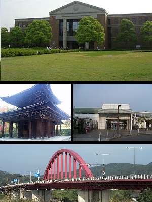 Top:A campus of Doshisha University, Middle left:Shuonan Temple, Middle right:Matsui Yamate Station, Bottom:Yamashiro Bridge | |
 Flag  Emblem | |
 Location of Kyōtanabe in Kyoto Prefecture | |
 | |
 Kyōtanabe Location in Japan | |
| Coordinates: 34°48′52″N 135°46′04″E / 34.81444°N 135.76778°E | |
| Country | Japan |
| Region | Kansai |
| Prefecture | Kyoto |
| Government | |
| • Mayor | Takashi Kamimura (since April 2019) |
| Area | |
| • Total | 42.92 km2 (16.57 sq mi) |
| Population (September 1, 2023) | |
| • Total | 71,757 |
| • Density | 1,700/km2 (4,300/sq mi) |
| Time zone | UTC+09:00 (JST) |
| City hall address | Tanabe 80, Kyōtanabe-shi, Kyoto-fu 610-0393 |
| Climate | Cfa |
| Website | Official website |
| Symbols | |
| Flower | Rhododendron pulchrum |
| Tree | Triadica sebifera |

Kyōtanabe (京田辺市, Kyōtanabe-shi) is a city located in the southern part of Kyoto Prefecture, Japan. As of 1 September 2023[update], the city has an estimated population of 71,757 in 31555 households and a population density of 1700 persons per km2.[1] The total area of the city is 42.92 square kilometres (16.57 sq mi).
Geography
Kyōtanabe is located in southern Kyoto Prefecture, bordered by Osaka Prefecture and Nara Prefecture. It is one of the three "Kansai Cultural and Academic Research City municipalities". The city is sandwiched between the Kizugawa River, which runs north–south on the east side of the city, and the Ikoma Mountains on the west.
Neighboring municipalities
Climate
Kyōtanabe has a humid subtropical climate (Köppen Cfa), featuring a marked seasonal variation in temperature and precipitation. Summers are hot and humid, but winters are relatively cold with occasional snowfall. The average annual temperature in Kyōtanabe is 15.3 °C (59.5 °F). The average annual rainfall is 1,429.8 mm (56.29 in) with June as the wettest month. The temperatures are highest on average in August, at around 27.5 °C (81.5 °F), and lowest in January, at around 4.1 °C (39.4 °F).[2] Its record high is 39.0 °C (102.2 °F), reached on 16 August 2007, and its record low is −6.8 °C (19.8 °F), reached on 27 February 1981.[3]
| Climate data for Kyōtanabe (1991−2020 normals, extremes 1978−present) | |||||||||||||
|---|---|---|---|---|---|---|---|---|---|---|---|---|---|
| Month | Jan | Feb | Mar | Apr | May | Jun | Jul | Aug | Sep | Oct | Nov | Dec | Year |
| Record high °C (°F) | 17.6 (63.7) |
22.4 (72.3) |
25.9 (78.6) |
30.6 (87.1) |
33.5 (92.3) |
37.5 (99.5) |
38.5 (101.3) |
39.0 (102.2) |
37.0 (98.6) |
32.7 (90.9) |
26.5 (79.7) |
23.3 (73.9) |
39.0 (102.2) |
| Mean daily maximum °C (°F) | 9.1 (48.4) |
10.0 (50.0) |
13.9 (57.0) |
19.9 (67.8) |
24.9 (76.8) |
28.0 (82.4) |
31.8 (89.2) |
33.4 (92.1) |
29.0 (84.2) |
23.2 (73.8) |
17.2 (63.0) |
11.6 (52.9) |
21.0 (69.8) |
| Daily mean °C (°F) | 4.1 (39.4) |
4.6 (40.3) |
8.0 (46.4) |
13.5 (56.3) |
18.6 (65.5) |
22.6 (72.7) |
26.5 (79.7) |
27.5 (81.5) |
23.4 (74.1) |
17.4 (63.3) |
11.3 (52.3) |
6.2 (43.2) |
15.3 (59.6) |
| Mean daily minimum °C (°F) | −0.6 (30.9) |
−0.4 (31.3) |
2.3 (36.1) |
7.2 (45.0) |
12.6 (54.7) |
18.0 (64.4) |
22.4 (72.3) |
23.0 (73.4) |
18.9 (66.0) |
12.4 (54.3) |
6.2 (43.2) |
1.4 (34.5) |
10.3 (50.5) |
| Record low °C (°F) | −6.6 (20.1) |
−6.8 (19.8) |
−4.1 (24.6) |
−2.1 (28.2) |
0.2 (32.4) |
6.7 (44.1) |
13.8 (56.8) |
14.5 (58.1) |
9.1 (48.4) |
2.6 (36.7) |
−1.8 (28.8) |
−5.1 (22.8) |
−6.8 (19.8) |
| Average precipitation mm (inches) | 51.0 (2.01) |
63.4 (2.50) |
108.0 (4.25) |
106.8 (4.20) |
141.0 (5.55) |
204.2 (8.04) |
181.5 (7.15) |
152.3 (6.00) |
156.9 (6.18) |
140.0 (5.51) |
74.0 (2.91) |
56.9 (2.24) |
1,429.8 (56.29) |
| Average precipitation days (≥ 1.0 mm) | 6.0 | 6.6 | 10.0 | 10.0 | 9.9 | 12.0 | 11.4 | 8.7 | 10.7 | 9.4 | 6.7 | 6.5 | 107.9 |
| Mean monthly sunshine hours | 130.5 | 127.8 | 167.2 | 186.3 | 201.9 | 155.0 | 170.9 | 216.7 | 163.3 | 162.8 | 141.4 | 138.0 | 1,961.8 |
| Source: Japan Meteorological Agency[3][2] | |||||||||||||
Demographics
Per Japanese census data, the population of Kyōtanabe in 2020 is 73,753 people.[4] Kyōtanabe's population has increased roughly sevenfold over the past century. The city has grown almost continuously since the census began in 1920, and saw especially rapid growth in the late 20th century.
|
| |||||||||||||||||||||||||||||||||||||||||||||||||||||||||||||||||||||
| Kyōtanabe population statistics[4] | ||||||||||||||||||||||||||||||||||||||||||||||||||||||||||||||||||||||
History
The area of Kyōtanabe was part of ancient Yamashiro Province. Kyōtanabe was briefly the capital of Japan during the reign of the legendary Kofun period Emperor Keitai. The life of the Imperial court was centered at Tsutsuki Palace where the emperor lived in 511–518.[5]The village of Tanabe in Tsuzuki District, Kyoto was established on April 1, 1889 with the creation of the modern municipalities system and was elevated to town status on October 12, 1906. On April 1, 1997 Tanabe was elevated to city status, as the 12th city in Kyoto Prefecture after Yawata, and the 669th city in Japan. In order to avoid confusion with Tanabe, Wakayama, the city was named "Kyōtanabe" by adding "Kyō" from Kyoto Prefecture.
Government
Kyōtanabe has a mayor-council form of government with a directly elected mayor and a unicameral city council of 20 members. Kyōtanabe, collectively with the municipalities of Tsuzuki District, Kyoto contributes two members to the Kyoto Prefectural Assembly. In terms of national politics, the city is part of the Kyoto 6th district of the lower house of the Diet of Japan.
Economy
Kyōtanabe has a mixed economy based on commerce, agriculture and light manufacturing. Tsubakimoto Chain, Dai Nippon Printing and Meiji) have major factories in the city.
Education
Colleges and universities
Primary and secondary education
Kyōtanabe has nine public elementary schools and three public junior high schools operated by city government and one public high school operated by the Kyoto Prefectural Board of Education. There is also one private junior high and one private high school.
Transportation
Railways
JR West - Katamachi Line (Gakkentoshi Line)
- JR Miyamaki - Dōshishamae - Kyōtanabe - Ōsumi - Matsuiyamate
Highways
Shin-Meishin Expressway
Daini Keihan Expressway
Keinawa Expressway
National Route 1
National Route 24
National Route 307
Local attractions
- Ōsumi Kurumazuka Kofun, National Historic Site
Notable people from Kyōtanabe
- Kenji Takao, running coach and former long-distance runner (10,000 metres)
- Takuya Muguruma, former football player
- Akinari Kawazura, football player (Omiya Ardija, J2 League)
- Meg Hemphill, track and field athlete
- Momo Hirai, singer, dancer, model, MC, member of South Korean girl group Twice
References
- ^ "Kyōtanabe City official statistics" (in Japanese). Japan.
- ^ a b 気象庁 / 平年値(年・月ごとの値). JMA. Retrieved March 28, 2022.
- ^ a b 観測史上1~10位の値(年間を通じての値). JMA. Retrieved March 28, 2022.
- ^ a b Kyōtanabe population statistics
- ^ Koch, W. (1904). Japan; Geschichte nach japanischen Quellen und ethnographische Skizzen. Mit einem Stammbaum des Kaisers von Japan, p. 13.
External links
Media related to Kyōtanabe, Kyoto at Wikimedia Commons
- Kyotanabe City official website (in Japanese)
- Kyotanabe City official website Archived 2012-05-12 at the Wayback Machine (in English)
| International | |
|---|---|
| National | |
| Geographic | |
This Kyoto Prefecture location article is a stub. You can help Wikipedia by expanding it. |