Pagudpud: Difference between revisions
No edit summary |
geographic naming conventions -- WP:PLACE -- South China Sea is the most common name in English for this body of water |
||
| Line 71: | Line 71: | ||
'''Pagudpud''' a fourth class municipality and a [[seaside resort|coastal resort town]] of [[Ilocos Norte]] province, in the northern [[Ilocos Region]] of the [[Philippines]]. According to the latest census, Pagudpud has a population of 20,385 people in 3,804 households. It is the northernmost settlement on [[Luzon]] Island. |
'''Pagudpud''' a fourth class municipality and a [[seaside resort|coastal resort town]] of [[Ilocos Norte]] province, in the northern [[Ilocos Region]] of the [[Philippines]]. According to the latest census, Pagudpud has a population of 20,385 people in 3,804 households. It is the northernmost settlement on [[Luzon]] Island. |
||
The town is bounded to the south by the town of [[Bangui, Ilocos Norte|Bangui]] and to the east by the [[Cordillera Mountain Range]], the town of [[Adams, Ilocos Norte|Adams]] and the province of [[Cagayan]]. The [[ |
The town is bounded to the south by the town of [[Bangui, Ilocos Norte|Bangui]] and to the east by the [[Cordillera Mountain Range]], the town of [[Adams, Ilocos Norte|Adams]] and the province of [[Cagayan]]. The [[South China Sea]] lies to the west and north. The town rolls over mountains, hills, valleys and flat coastal land. It lies {{convert|45|mi|km}} north of [[Laoag City]], the provincial capital, and about {{convert|350|mi|km}} north of [[Manila]]. They reside in 3,804 homes that are spread across {{convert|83|sqmi|km2}}. Most make their living through farming, fishing and subsistence retailing. Tourism is a growing part of the economy. |
||
Pagudpud was made a municipality on February 3, 1954. Unlike [[Laoag]] City, the province's only autonomous city, Pagudpud derives its authority from the provincial government. It had previously been a part of the neighboring town of [[Bangui, Ilocos Norte|Bangui]]. |
Pagudpud was made a municipality on February 3, 1954. Unlike [[Laoag]] City, the province's only autonomous city, Pagudpud derives its authority from the provincial government. It had previously been a part of the neighboring town of [[Bangui, Ilocos Norte|Bangui]]. |
||
| Line 133: | Line 133: | ||
{{Geographic location |
{{Geographic location |
||
| North=''[[Luzon Strait]]'' |
| North=''[[Luzon Strait]]'' |
||
| West=''[[ |
| West=''[[South China Sea]]'' |
||
| Center=Pagudpud |
| Center=Pagudpud |
||
| East=[[Santa Praxedes, Cagayan]] |
| East=[[Santa Praxedes, Cagayan]] |
||
Revision as of 02:36, 12 March 2013
Pagudpud
Bayan ng Pagudpud | |
|---|---|
 From top to bottom right: Welcome arch passing through Pan-Philippine Highway, Dos Hermanos islands, Bantay Abot cave, Patapat Viaduct overlooking Pasaleng Bay, and Blue Lagoon | |
 Seal | |
 Map of Ilocos Norte showing the location of Pagudpud | |
| Country | |
| Region | Ilocos Region (Region I) |
| Province | Ilocos Norte |
| District | 1st District |
| Founded | February 3, 1954 |
| Barangays | 16 |
| Government | |
| • Mayor | Matilde Henson-Sales |
| Area | |
| • Total | 194.90 km2 (75.25 sq mi) |
| Population (2007) | |
| • Total | 20,385 |
| • Density | 100/km2 (270/sq mi) |
| Time zone | UTC+8 (PST) |
| ZIP code | 2919 |
| Dialing code | 77 |
| Income class | 4th class |
| Year | Pop. | ±% p.a. |
|---|---|---|
| 1995 | 17,168 | — |
| 2000 | 19,315 | +2.56% |
| 2007 | 20,385 | +0.75% |
Pagudpud a fourth class municipality and a coastal resort town of Ilocos Norte province, in the northern Ilocos Region of the Philippines. According to the latest census, Pagudpud has a population of 20,385 people in 3,804 households. It is the northernmost settlement on Luzon Island.
The town is bounded to the south by the town of Bangui and to the east by the Cordillera Mountain Range, the town of Adams and the province of Cagayan. The South China Sea lies to the west and north. The town rolls over mountains, hills, valleys and flat coastal land. It lies 45 miles (72 km) north of Laoag City, the provincial capital, and about 350 miles (560 km) north of Manila. They reside in 3,804 homes that are spread across 83 square miles (210 km2). Most make their living through farming, fishing and subsistence retailing. Tourism is a growing part of the economy.
Pagudpud was made a municipality on February 3, 1954. Unlike Laoag City, the province's only autonomous city, Pagudpud derives its authority from the provincial government. It had previously been a part of the neighboring town of Bangui.
There are no ATM"s in Pagudpud. The nearest ATM is in Loang which is about 2 hours on a local bus.
Barangays
Pagudpud is politically subdivided into 16 barangays, or town districts.
- Aggasi
- Baduang
- Balaoi
- Burayoc
- Caunayan
- Dampig
- Ligaya
- Pancian
- Pasaleng
- Poblacion 1
- Poblacion 2
- Saguigui
- Saud
- Subec
- Tarrag
- Caparispisan
Highlights
Its white-sand beaches and crystal-blue water makes Pagudpud a haven for tourists. Maira-Ira Point is also an emerging attraction with its secluded beach known as the Blue Lagoon, as well as kilometer-long Saud Beach. Access to this public beach is from a secondary concrete road on the north side of the Maharlika Highway just before approaching the Patapat Viaduct. On the way to the Blue Lagoon, a sea arch can be seen. Coconut trees line much of the town's coast. On a clear day, the Babuyan Islands are visible from Patapat National Park.
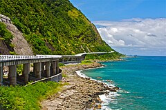
The Patapat Viaduct, elevated 31 metres (102 ft) above sea level, is 1.3 kilometres (0.81 mi) concrete coastal viaduct that connects the Maharlika Highway from Laoag to the Cagayan Valley Region. It rises along the town's coastal mountains, which is the starting point of the Cordillera Mountain Range that snakes through Northern Luzon. It is the 4th longest bridge in the Philippines. Located more than 16 kilometers from the town proper, it offers a scenic view of Pasaleng Bay- a view that leads towards wide and pristine beaches backed by mountains with breathtaking waterfalls Kabigan and Mabaga, along with the many cool, refreshing springs waiting to be discovered within.
Kabigan Falls is surrounded by thick forest and well known for its concaved basin, located at the eastern part of Barangay Balaoi, about 1.8 kilometres (1.1 mi) away from the national highway. Kabigan falls is also part of the town of Pagudpud, Ilocos Norte and a trek going to this falls is usually included in the tricycle tour offered in the area. There is a 20 Pesos/pax entrance fee at the jump-off point where you will be assigned your official trek guide going to the falls. You don't have to worry about being lost or being conned in the area because the locals organized their official group to guide tourist and receive payment. The trek going to Kabigan Falls takes 30 to 40 minutes mostly of flat area so you'll have time to enjoy the verdant panorama. Although there is a visible trail going to the falls, you'll still need a tour guide if it's your first time there just to be safe.
Transportation
By land, Pagudpud is approximately a 90 minute bus ride from Laoag City. Several bus lines serve the Manila-Laoag route, namely Partas, Florida, Farinas, and Maria de Leon among others.
Gallery
-
Kabigan Falls in Pagudpud
-
Sunset at Burayoc Point at the juncture of Saud Beach near Pagudpud Rinnovati.
-
Saud Beach near Polaris Beach House
-
Saud Beach near Apo Idon resort. The Northwind Power windmills in neighboring Bangui can be seen in the distance.
-
The Patapat Viaduct
-
Saud Beach


See also
External links
- Municipality of Pagudpud
- Article about Pagudpud and Saud Beach with plenty of Photographs
- Philippine Standard Geographic Code
- 1995 Philippine Census Information
- 2000 Philippine Census Information
- 2007 Philippine Census Information
- Local Governance Performance Management System
Places adjacent to Pagudpud | |
|---|---|
Laoag (capital and largest city) | |
| Municipalities | |
| Component cities | |
| Barangays | |