Pelm: Difference between revisions
m Rename template in English |
m Disambiguating links to Ortsgemeinde (link changed to Ortsgemeinde (Germany)) using DisamAssist. |
||
| (37 intermediate revisions by 26 users not shown) | |||
| Line 1: | Line 1: | ||
{{Infobox German location |
{{Infobox German location |
||
|image_photo = |
|image_photo = |
||
| |
|image_coa = DEU Pelm COA.svg |
||
|coordinates = {{coord|50|14|01|N|6|41|28|E|format=dms|display=inline,title}} |
|||
|lat_deg = 50 |lat_min = 14 |lat_sec = 01 |
|||
|image_plan = Pelm in DAU.svg |
|||
|lon_deg = 6 |lon_min = 41 |lon_sec = 28 |
|||
| |
|state = Rheinland-Pfalz |
||
| |
|district = Vulkaneifel |
||
|Landkreis = Vulkaneifel |
|||
|Verbandsgemeinde = Gerolstein |
|Verbandsgemeinde = Gerolstein |
||
| |
|elevation = 370 |
||
| |
|area = 10.06 |
||
| |
|postal_code = 54570 |
||
| |
|area_code = 06591 |
||
| |
|licence = DAU |
||
|Vorwahl = 06591 |
|||
|Kfz = DAU |
|||
|Gemeindeschlüssel = 07 2 33 056 |
|Gemeindeschlüssel = 07 2 33 056 |
||
|website = [http://www.pelm.de/ www.pelm.de] |
|||
|Adresse-Verband = Kyllweg 1<br />54568 Gerolstein |
|||
|mayor = Leo Meeth<ref name=mayor>[https://www.wahlen.rlp.de/de/kw/wahlen/kd/gebiete/2330000000000.html Direktwahlen 2019, Landkreis Vulkaneifel], Landeswahlleiter Rheinland-Pfalz, accessed 10 August 2021.</ref> |
|||
|Website = [http://www.pelm.de/ www.pelm.de] |
|||
|leader_term = 2019–24 |
|||
|Bürgermeister = Wolfgang Zaeper |
|||
}} |
}} |
||
'''Pelm''' is an ''[[Ortsgemeinde (Germany)|Ortsgemeinde]]'' – a [[Municipalities of Germany|municipality]] belonging to a ''[[Verbandsgemeinde]]'', a kind of collective municipality – in the [[Vulkaneifel]] [[Districts of Germany|district]] in [[Rhineland-Palatinate]], [[Germany]]. It belongs to the [[Gerolstein (Verbandsgemeinde)|''Verbandsgemeinde'' of Gerolstein]], whose seat is in the [[Gerolstein|like-named town]]. |
|||
== Geography == |
|||
'''Pelm''' is a municipality in the [[Vulkaneifel|district of Vulkaneifel]], in [[Rhineland-Palatinate]], western [[Germany]]. |
|||
=== Location === |
|||
{{Cities and towns in Vulkaneifel (district)}} |
|||
The municipality lies on the river [[Kyll]] in the [[Vulkan Eifel|Vulkaneifel]], a part of the [[Eifel]] known for its volcanic history, geographical and geological features, and even ongoing activity today, including gases that sometimes well up from the earth. |
|||
=== Neighbouring municipalities === |
|||
[[Category:Municipalities in Rhineland-Palatinate]] |
|||
Pelm's neighbours are [[Gerolstein]], [[Rockeskyll]], [[Berlingen, Germany|Berlingen]], [[Dohm-Lammersdorf]] and [[Hohenfels-Essingen]]. |
|||
== History == |
|||
{{Vulkaneifel-geo-stub}} |
|||
[[File:gerolstein kasselburg axb01.jpg|thumb|left|Ruins of the [[Kasselburg]]]] |
|||
Pelm is notable for its connection with ancient history. |
|||
Unearthed to the west of the village was a [[Gallo-Roman culture|Gallo-Roman]] sanctuary. It had already been widely destroyed by graverobbers by the time a systematic investigation was done in 1928. More recently, newer information was brought to light by a [[Excavation (archaeology)|dig]] undertaken in 1986 by the [[Rheinisches Landesmuseum Trier|Trier Rhenish State Museum]]. The [[trapezoid]]al wall that once bounded the hallowed grounds, whose greatest length is 65 m and whose greatest breadth is 42 m, was built of [[limestone]]. Inside is a Gallo-Roman temple with a [[cella]] and a passageway in which a limestone tablet was found as early as 1833 inscribed with a dedication to the goddess Caiva. The tablet mentions that a man named Marcus Victorius Polentius granted an endowment of 100,000 [[Sestertius|sestertii]] for the temple to Caiva to be built. This inscription has been dated to AD 124. |
|||
[[de:Pelm]] |
|||
[[eo:Pelm]] |
|||
There were two other temples on the grounds. At one, a fragmentary red [[sandstone]] club, likely from a [[statue]] of [[Hercules]], was found in 1986. A torso from such a statue was unearthed in 1834, but has since been lost. Other statuary has been found representing [[Mercury (mythology)|Mercury]] and [[Venus (mythology)|Venus]], for instance. |
|||
[[nl:Pelm]] |
|||
[[ro:Pelm]] |
|||
Coins, too, have been found, from a [[quinarius]] minted in Africa in 47 or 46 BC to various coins struck about AD 400. One find, a [[fibula (brooch)|fibula]], dates from early [[La Tène culture|La Tène times]].<ref>[http://www.roscheiderhof.de/kulturdb/client/einObjekt.php?id=1588 Gallo-Roman Sanctuary, ''Judenkirchhof'']</ref> |
|||
[[ru:Пельм]] |
|||
[[vo:Pelm]] |
|||
In the [[Middle Ages]], the village was held by the House of Kasselburg, whose [[castle]] seat was in the village. It gave the noble family its name, and is still known today as the [[Kasselburg]].<ref>[http://www.jahrbuch-vulkaneifel.de/VT/hjb1988/hjb1988.64.htm Pelm’s armorial history up to 1988] {{webarchive|url=https://web.archive.org/web/20110719050121/http://www.jahrbuch-vulkaneifel.de/VT/hjb1988/hjb1988.64.htm |date=2011-07-19 }}</ref> |
|||
On 18 May 1897, Pelm was the site of a [[railway]] disaster when a troop train crashed into some uncoupled [[rolling stock]] causing seven of the train's coaches to [[Derailment|derail]]. In the accident, ensuing chaos and fire, ten men – nine military personnel and one civilian – were killed. Many more were wounded.<ref>{{Cite web |url=http://www.jahrbuch-vulkaneifel.de/VT/hjb1997/hjb1997.48.htm |title=Account of the 1897 Pelm railway disaster |access-date=2010-07-20 |archive-url=https://web.archive.org/web/20110719050237/http://www.jahrbuch-vulkaneifel.de/VT/hjb1997/hjb1997.48.htm |archive-date=2011-07-19 |url-status=dead }}</ref> |
|||
== Politics == |
|||
=== Municipal council === |
|||
The council is made up of 16 council members, who were elected by [[proportional representation]] at the municipal election held on 7 June 2009, and the honorary mayor as chairman. |
|||
The municipal election held on 7 June 2009 yielded the following results:<ref>[http://wahlen.rlp.de/kw/wahlen/2009/gemeinderatswahlen/ergebnisse/2330205600.html Kommunalwahl Rheinland-Pfalz 2009, Gemeinderat]</ref> |
|||
{| border="1" cellpadding="2" cellspacing="0" width="300" |
|||
|- bgcolor="#eeeeee" align="center" |
|||
| || [[Christian Democratic Union of Germany|CDU]] || [[Free Voters|FWG]] || '''Total''' |
|||
|- align="center" |
|||
| 2009 || 4 || 12 || 16 seats |
|||
|- align="center" |
|||
| 2004 || 6 || 10 || 16 seats |
|||
|} |
|||
=== Mayor === |
|||
Pelm's mayor is Leo Meeth.<ref name=mayor/> |
|||
=== Coat of arms === |
|||
The German blazon reads: ''Gespalten von Grün und Silber, über einem von Silber und Blau gespaltenen Wellenbalken zwei goldene Zinnentürme, eine goldene Zinnenmauer flankierend, Tor und Fenster betagleuchtet, hinten ein rotes Vortragkreuz.'' |
|||
The municipality's [[Coat of arms|arms]] might in English [[Heraldry|heraldic]] language be described thus: Per pale vert a fess wavy abased argent above which a wall flanked by two towers all embattled Or, gate and windows sable, and argent a fess wavy abased conjoined as one to the other azure issuant from which a processional cross gules. |
|||
The 1988 Vulkaneifel Yearbook shows different arms for Pelm with the tower-flanked gatehouse as the only [[charge (heraldry)|charge]], issuant from base. The field [[tincture (heraldry)|tincture]]s was different, too, the gatehouse still being in Or (gold), but the field in sable (black). The composition on the sinister (armsbearer's left, viewer's right) side did not appear at all.<ref>[http://www.jahrbuch-vulkaneifel.de/VT/hjb1988/hjb1988.64.htm Different arms in 1988 Vulkaneifel Yearbook] {{webarchive|url=https://web.archive.org/web/20110719050121/http://www.jahrbuch-vulkaneifel.de/VT/hjb1988/hjb1988.64.htm |date=2011-07-19 }}</ref> |
|||
Nonetheless, in both forms of the arms, the gatehouse represents the local [[Middle Ages|mediaeval]] landmark, the Kasselburg ([[castle]]). |
|||
== Culture and sightseeing == |
|||
Buildings: |
|||
* [[Willibrord|Saint Willibrord's]] [[Roman Catholicism|Catholic]] Church (branch church; ''Filialkirche St. Willibrord''), Hauptstraße – [[Romanesque architecture|Romanesque]] west tower, nave from 1746, expanded in 1965. |
|||
* Bahnhofstraße 14 – ''Quereinhaus'' (a combination residential and commercial house divided for these two purposes down the middle, perpendicularly to the street) from 1878. |
|||
* Bahnhofstraße 1 – small [[Baroque architecture|Baroque]] ''Quereinhaus'' (?). |
|||
* Gerolsteiner Straße 6 – building with half-hipped roof, about 1800. |
|||
* Gerolsteiner Straße 7 – two-floor solid building with small windows. |
|||
* Before Hauptstraße 2 – warriors’ memorial 1914-1918, [[crucifix]] 1850, on base built in 1919. |
|||
* Across the street from Hauptstraße 8 – wayside cross, red [[sandstone]] [[shaft cross]] from the earlier half of the 18th century. |
|||
* Hauptstraße 18 – stately house from an old estate along the street, early 19th century. |
|||
* Hauptstraße 19 – small ''Quereinhaus'' apparently from 1742, Baroque entrance, appearance largely 19th century. |
|||
* Between Hauptstraße 19 and 23 – wayside cross, red sandstone beam cross from 1762. |
|||
* Hauptstraße 46 – ''Quereinhaus'' about 1800 (?), [[Classicism|Classicist]] doorframe, late 19th century. |
|||
* Memorial, north of the village on the [[railway]] right-of-way – to those who lost their lives in the accident on 18 May 1897, possibly from shortly thereafter. |
|||
* Former Gerolstein railway works yard, southwest of the village on the way to [[Gerolstein]] (Kasselburger Weg) – monumental zone, [[Railway roundhouse|roundhouse]], depot/administration building/workshop, 1928-1930, rebuilt in 1949/1950 after wartime destruction. |
|||
* ''Heiligenhäuschen'' (a small, shrinelike structure consecrated to a saint or saints), south of the village on the road from Gees to Gerolstein – red sandstone from 1768. |
|||
* Kasselburg – monumental zone, [[castle]] founded in the 12th century, among [[Eifel]] castles one of the stateliest and best preserved, parts from 13th, 14th and 15th centuries, eight-floor dwelling tower, three-floor hall building with built-on [[chapel]], mid 14th century, [[keep]], lower part of which is [[Romanesque architecture|Romanesque]], remnants of dwelling and commercial buildings, square gatetower, 15th century; complex includes broad area. |
|||
* So-called ''Judenkirchhof'' (“Jewish Churchyard”), west of the village on the hill – [[Gallo-Roman culture|Gallo-Roman]] temple complex, AD 124.<ref>[http://denkmallisten.gdke-rlp.de/Vulkaneifel.pdf Directory of Cultural Monuments in Vulkaneifel district]</ref> |
|||
== References == |
|||
{{reflist}} |
|||
== External links == |
|||
* [http://www.pelm.de/ Municipality’s official webpage] {{in lang|de}} |
|||
{{Cities and towns in Vulkaneifel (district)}} |
|||
{{Authority control}} |
|||
[[Category:Municipalities in Rhineland-Palatinate]] |
|||
[[Category:Populated places in the Eifel]] |
|||
[[Category:Vulkaneifel]] |
|||
Latest revision as of 17:24, 1 June 2023
Pelm | |
|---|---|
 Coat of arms | |
Location of Pelm within Vulkaneifel district  | |
 Pelm 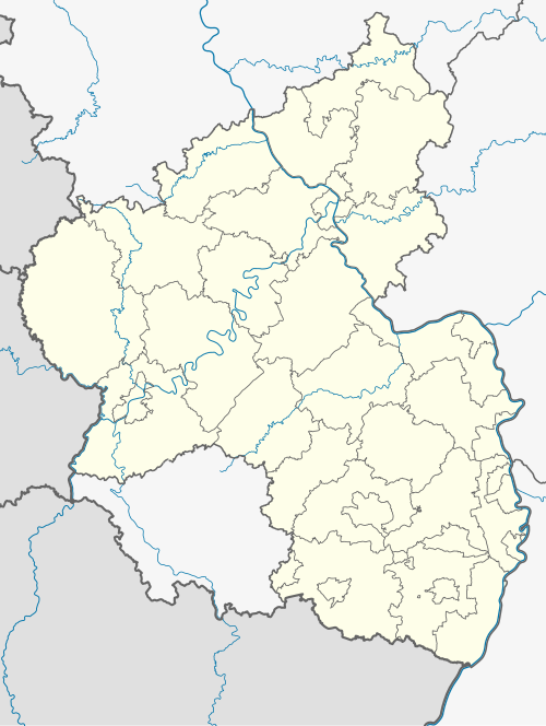 Pelm | |
| Coordinates: 50°14′01″N 6°41′28″E / 50.23361°N 6.69111°E | |
| Country | Germany |
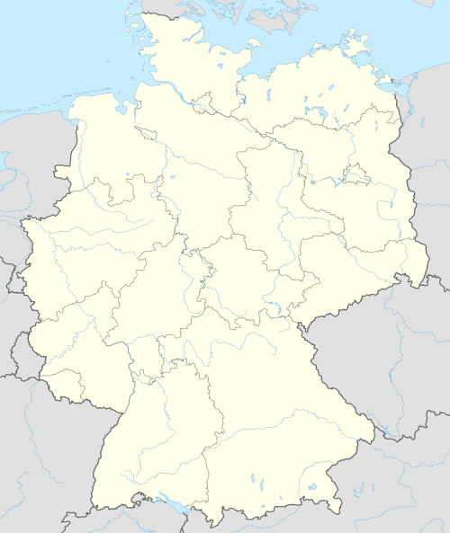
| State | Rhineland-Palatinate |
| District | Vulkaneifel |
| Municipal assoc. | Gerolstein |
| Government | |
| • Mayor (2019–24) | Leo Meeth[1] |
| Area | |
| • Total | 10.06 km2 (3.88 sq mi) |
| Elevation | 370 m (1,210 ft) |
| Population (2022-12-31)[2] | |
| • Total | 941 |
| • Density | 94/km2 (240/sq mi) |
| Time zone | UTC+01:00 (CET) |
| • Summer (DST) | UTC+02:00 (CEST) |
| Postal codes | 54570 |
| Dialling codes | 06591 |
| Vehicle registration | DAU |
| Website | www.pelm.de |
Pelm is an Ortsgemeinde – a municipality belonging to a Verbandsgemeinde, a kind of collective municipality – in the Vulkaneifel district in Rhineland-Palatinate, Germany. It belongs to the Verbandsgemeinde of Gerolstein, whose seat is in the like-named town.
Geography
[edit]Location
[edit]The municipality lies on the river Kyll in the Vulkaneifel, a part of the Eifel known for its volcanic history, geographical and geological features, and even ongoing activity today, including gases that sometimes well up from the earth.
Neighbouring municipalities
[edit]Pelm's neighbours are Gerolstein, Rockeskyll, Berlingen, Dohm-Lammersdorf and Hohenfels-Essingen.
History
[edit]
Pelm is notable for its connection with ancient history.
Unearthed to the west of the village was a Gallo-Roman sanctuary. It had already been widely destroyed by graverobbers by the time a systematic investigation was done in 1928. More recently, newer information was brought to light by a dig undertaken in 1986 by the Trier Rhenish State Museum. The trapezoidal wall that once bounded the hallowed grounds, whose greatest length is 65 m and whose greatest breadth is 42 m, was built of limestone. Inside is a Gallo-Roman temple with a cella and a passageway in which a limestone tablet was found as early as 1833 inscribed with a dedication to the goddess Caiva. The tablet mentions that a man named Marcus Victorius Polentius granted an endowment of 100,000 sestertii for the temple to Caiva to be built. This inscription has been dated to AD 124.
There were two other temples on the grounds. At one, a fragmentary red sandstone club, likely from a statue of Hercules, was found in 1986. A torso from such a statue was unearthed in 1834, but has since been lost. Other statuary has been found representing Mercury and Venus, for instance.
Coins, too, have been found, from a quinarius minted in Africa in 47 or 46 BC to various coins struck about AD 400. One find, a fibula, dates from early La Tène times.[3]
In the Middle Ages, the village was held by the House of Kasselburg, whose castle seat was in the village. It gave the noble family its name, and is still known today as the Kasselburg.[4]
On 18 May 1897, Pelm was the site of a railway disaster when a troop train crashed into some uncoupled rolling stock causing seven of the train's coaches to derail. In the accident, ensuing chaos and fire, ten men – nine military personnel and one civilian – were killed. Many more were wounded.[5]
Politics
[edit]Municipal council
[edit]The council is made up of 16 council members, who were elected by proportional representation at the municipal election held on 7 June 2009, and the honorary mayor as chairman.
The municipal election held on 7 June 2009 yielded the following results:[6]
| CDU | FWG | Total | |
| 2009 | 4 | 12 | 16 seats |
| 2004 | 6 | 10 | 16 seats |
Mayor
[edit]Pelm's mayor is Leo Meeth.[1]
Coat of arms
[edit]The German blazon reads: Gespalten von Grün und Silber, über einem von Silber und Blau gespaltenen Wellenbalken zwei goldene Zinnentürme, eine goldene Zinnenmauer flankierend, Tor und Fenster betagleuchtet, hinten ein rotes Vortragkreuz.
The municipality's arms might in English heraldic language be described thus: Per pale vert a fess wavy abased argent above which a wall flanked by two towers all embattled Or, gate and windows sable, and argent a fess wavy abased conjoined as one to the other azure issuant from which a processional cross gules.
The 1988 Vulkaneifel Yearbook shows different arms for Pelm with the tower-flanked gatehouse as the only charge, issuant from base. The field tinctures was different, too, the gatehouse still being in Or (gold), but the field in sable (black). The composition on the sinister (armsbearer's left, viewer's right) side did not appear at all.[7]
Nonetheless, in both forms of the arms, the gatehouse represents the local mediaeval landmark, the Kasselburg (castle).
Culture and sightseeing
[edit]Buildings:
- Saint Willibrord's Catholic Church (branch church; Filialkirche St. Willibrord), Hauptstraße – Romanesque west tower, nave from 1746, expanded in 1965.
- Bahnhofstraße 14 – Quereinhaus (a combination residential and commercial house divided for these two purposes down the middle, perpendicularly to the street) from 1878.
- Bahnhofstraße 1 – small Baroque Quereinhaus (?).
- Gerolsteiner Straße 6 – building with half-hipped roof, about 1800.
- Gerolsteiner Straße 7 – two-floor solid building with small windows.
- Before Hauptstraße 2 – warriors’ memorial 1914-1918, crucifix 1850, on base built in 1919.
- Across the street from Hauptstraße 8 – wayside cross, red sandstone shaft cross from the earlier half of the 18th century.
- Hauptstraße 18 – stately house from an old estate along the street, early 19th century.
- Hauptstraße 19 – small Quereinhaus apparently from 1742, Baroque entrance, appearance largely 19th century.
- Between Hauptstraße 19 and 23 – wayside cross, red sandstone beam cross from 1762.
- Hauptstraße 46 – Quereinhaus about 1800 (?), Classicist doorframe, late 19th century.
- Memorial, north of the village on the railway right-of-way – to those who lost their lives in the accident on 18 May 1897, possibly from shortly thereafter.
- Former Gerolstein railway works yard, southwest of the village on the way to Gerolstein (Kasselburger Weg) – monumental zone, roundhouse, depot/administration building/workshop, 1928-1930, rebuilt in 1949/1950 after wartime destruction.
- Heiligenhäuschen (a small, shrinelike structure consecrated to a saint or saints), south of the village on the road from Gees to Gerolstein – red sandstone from 1768.
- Kasselburg – monumental zone, castle founded in the 12th century, among Eifel castles one of the stateliest and best preserved, parts from 13th, 14th and 15th centuries, eight-floor dwelling tower, three-floor hall building with built-on chapel, mid 14th century, keep, lower part of which is Romanesque, remnants of dwelling and commercial buildings, square gatetower, 15th century; complex includes broad area.
- So-called Judenkirchhof (“Jewish Churchyard”), west of the village on the hill – Gallo-Roman temple complex, AD 124.[8]
References
[edit]- ^ a b Direktwahlen 2019, Landkreis Vulkaneifel, Landeswahlleiter Rheinland-Pfalz, accessed 10 August 2021.
- ^ "Bevölkerungsstand 2022, Kreise, Gemeinden, Verbandsgemeinden" (PDF) (in German). Statistisches Landesamt Rheinland-Pfalz. 2023.
- ^ Gallo-Roman Sanctuary, Judenkirchhof
- ^ Pelm’s armorial history up to 1988 Archived 2011-07-19 at the Wayback Machine
- ^ "Account of the 1897 Pelm railway disaster". Archived from the original on 2011-07-19. Retrieved 2010-07-20.
- ^ Kommunalwahl Rheinland-Pfalz 2009, Gemeinderat
- ^ Different arms in 1988 Vulkaneifel Yearbook Archived 2011-07-19 at the Wayback Machine
- ^ Directory of Cultural Monuments in Vulkaneifel district
External links
[edit]- Municipality’s official webpage (in German)

| International | |
|---|---|
| National | |
| Geographic | |