Sakaba
Sakaba
dirin daji | |
|---|---|
LGA and town | |
| Coordinates: 11°9′44″N 5°32′29″E / 11.16222°N 5.54139°E | |
| Country | |
| State | Kebbi State |
| Time zone | UTC+1 (WAT) |
 | |
Sakaba is a Local Government Area under zuru emirate in Kebbi State, Nigeria. Its headquarters are in the town of Dirindaji..and has many tribe
Here's a possible introduction for a local government:
"Welcome to [sakaba local Government], dedicated to serving the needs of our vibrant community. As the closest level of government to the people, we strive to deliver effective and responsive governance, ensuring the well-being, safety, and prosperity of our residents.
Our mission is to provide quality services, foster economic growth, and enhance the quality of life for all citizens, while promoting transparency, accountability, and community engagement. We are committed to building a stronger, more resilient community, where everyone has the opportunity to thrive."
It has an area of 1,260 km2 and a population of 89,937 at the 2006 census.
The postal code of the area is 872.[1]
Climate
With an average yearly temperature of 32.68°C, Sakaba, Nigeria's savanna climate, has a tropical wet and dry climate that is 3.22% warmer than the country's average.[2][3]
References
- ^ "Post Offices- with map of LGA". NIPOST. Archived from the original on 2012-11-26. Retrieved 2009-10-20.
- ^ "Sakaba, Kebbi, NG Climate Zone, Monthly Averages, Historical Weather Data". tcktcktck.org. Retrieved 2023-09-10.
- ^ "Sakaba Climate, Weather By Month, Average Temperature (Nigeria) - Weather Spark". weatherspark.com. Retrieved 2023-09-10.
State capital: Birnin Kebbi | ||
| Local government areas | 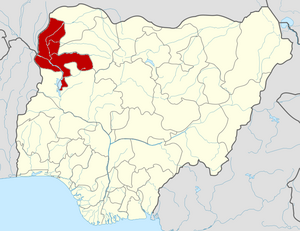 | |
This Kebbi State, Nigeria location article is a stub. You can help Wikipedia by expanding it. |