Seaside, California: Difference between revisions
No edit summary |
Red Director (talk | contribs) |
||
| (374 intermediate revisions by more than 100 users not shown) | |||
| Line 1: | Line 1: | ||
{{Short description|City in California, United States}} |
|||
'''Seaside''' is a city in [[Monterey County, California]], with a total population of 31,696 as of the [[2000]] census. However, because of illegal immigration, the number is probably ten percent higher. |
|||
{{Use mdy dates|date=May 2024}} |
|||
{{Infobox settlement |
|||
|name = Seaside, California |
|||
|official_name = |
|||
|settlement_type = [[List of municipalities in California|City]] |
|||
|image_skyline = USPS - Seaside, CA 93955.jpg |
|||
|imagesize = |
|||
|image_caption = Post office in Seaside |
|||
|image_flag = Flag of Seaside, California.gif |
|||
|image_seal = Seaside California seal.jpg |
|||
|insigniacaption = Seal of Seaside |
|||
|image_map = Monterey County California Incorporated and Unincorporated areas Seaside Highlighted.svg |
|||
|mapsize = 250x200px |
|||
|map_caption = Location in [[Monterey County, California|Monterey County]] and the state of [[California]] |
|||
|image_map1 = |
|||
|mapsize1 = |
|||
|map_caption1 = |
|||
|pushpin_map = USA |
|||
|pushpin_map_caption = Location in the United States |
|||
|pushpin_label = Seaside |
|||
|pushpin_relief = 1 |
|||
|subdivision_type = [[List of sovereign states|Country]] |
|||
|subdivision_name = United States |
|||
|subdivision_type1 = [[U.S. state|State]] |
|||
|subdivision_name1 = [[California]] |
|||
|subdivision_type2 = [[List of counties in California|County]] |
|||
|subdivision_name2 = [[Monterey County, California|Monterey]] |
|||
|government_type = |
|||
|leader_title = [[List of mayors of Seaside, California|Mayor]] |
|||
|leader_name = Ian Oglesby<ref>{{Cite web|url=http://www.ci.seaside.ca.us/index.aspx?page=318|access-date=September 18, 2014|title=Mayor & City Council|publisher=City of Seaside, CA}}</ref> |
|||
|leader_title1 = [[California State Senate|Senate]] |
|||
|leader_name1 = [[Bill Monning]] ([[California Democratic Party|D]]) |
|||
|leader_title2 = [[California State Assembly|Assembly]] |
|||
|leader_name2 = [[Mark Stone (politician)|Mark Stone]] ([[California Democratic Party|D]]) |
|||
|leader_title3 = [[California's 19th congressional district|U. S. Congress]] |
|||
|leader_name3 = {{Representative|cacd|19|fmt=usleader}}<ref>{{Cite GovTrack|CA|19|access-date=September 24, 2014}}</ref> |
|||
|established_title = Founded |
|||
|established_date = 1888<ref>Clark, Donald Thomas (1991) Monterey County Place Names. Carmel Valley, Calif.: Kestrel Press. p. 476. {{ISBN|1-880478-01-3}}</ref> |
|||
|established_title2 = [[Municipal corporation|Incorporated]] |
|||
|established_date2 = October 13, 1954<ref>{{Cite web |
|||
|url = http://www.calafco.org/docs/Cities_by_incorp_date.doc |
|||
|title = California Cities by Incorporation Date |
|||
|format = Word |
|||
|publisher = California Association of [[Local Agency Formation Commission]]s |
|||
|access-date = August 25, 2014 |
|||
|url-status = dead |
|||
|archive-url = https://web.archive.org/web/20141103002921/http://www.calafco.org/docs/Cities_by_incorp_date.doc |
|||
|archive-date = November 3, 2014 |
|||
|df = mdy-all |
|||
}}</ref> |
|||
<!-- Area------------------> |
|||
| unit_pref = Imperial |
|||
| area_footnotes = <ref name="CenPopGazetteer2022">{{cite web |title=2022 U.S. Gazetteer Files: California |url=https://www2.census.gov/geo/docs/maps-data/data/gazetteer/2022_Gazetteer/2022_gaz_place_06.txt |publisher=United States Census Bureau |accessdate=November 14, 2022}}</ref> |
|||
| area_total_sq_mi = 9.06 |
|||
| area_land_sq_mi = 8.92 |
|||
| area_water_sq_mi = 0.14 |
|||
| area_total_km2 = |
|||
| area_land_km2 = |
|||
| area_water_km2 = |
|||
| area_water_percent = 1.51 |
|||
| area_note = |
|||
|elevation_ft = 33 |
|||
|elevation_m = 10 |
|||
|elevation_footnotes = <ref name=gnis>{{gnis|1659619}}</ref> |
|||
<!-- Population -----------> |
|||
|population_as_of = [[2020 United States census|2020]] |
|||
|population_footnotes = <ref name="Census 2020">{{Cite web| url=https://data.census.gov/cedsci/table?q=&g=1600000US0670742&tid=DECENNIALPL2020.P1| title=P1. Race – Seaside city, California: 2020 DEC Redistricting Data (PL 94-171)| publisher=U.S. Census Bureau| access-date=November 14, 2022}}</ref> |
|||
|population_total = 32366 |
|||
|pop_est_as_of = |
|||
|pop_est_footnotes = |
|||
|population_est = |
|||
|population_density_sq_mi = 3627.3 |
|||
|population_density_km2 = |
|||
|population_metro = |
|||
|coordinates = {{coord|36|36|40|N|121|50|41|W|region:US-CA|display=inline,title}} |
|||
|timezone = [[Pacific Time Zone|PST]] |
|||
|utc_offset = -8 |
|||
|timezone_DST = PDT |
|||
|utc_offset_DST = -7 |
|||
|postal_code_type = [[ZIP code]] |
|||
|postal_code = 93955 |
|||
|area_code = [[Area code 831|831]] |
|||
|blank_name = [[Federal Information Processing Standard|FIPS code]] |
|||
|blank_info = 06-70742 |
|||
|blank1_name = [[Geographic Names Information System|GNIS]] feature ID |
|||
|blank1_info = {{GNIS 4|1659619}} |
|||
|website = {{URL|www.ci.seaside.ca.us}} |
|||
|footnotes = |
|||
}} |
|||
'''Seaside''', formerly '''East Monterey''', is a city in [[Monterey County, California|Monterey County]], [[California]], [[United States]], with a population of 32,366 as of the 2020 census.<ref name="Census 2020"/> It is located {{convert|2.25|mi|km|1}} east-northeast of [[Monterey, California|Monterey]],<ref name=CGN>{{California's Geographic Names|958}}</ref> at an elevation of {{convert|33|ft|m}},<ref name=gnis /> and is the home of [[California State University, Monterey Bay]] (CSUMB), UC MBEST Center, and the [[Monterey College of Law]], which are located on the site of the former military base [[Fort Ord]]. Also on the site are the Bayonet and Black Horse golf courses, now open to the public and host to [[PGA Tour]] events,<ref name="Monterey County Convention and Visitors Bureau">{{cite web|url=http://www.montereyinfo.org/seaside/bayonetandblackhorse|title=Bayonet Golf Course|work=montereyinfo.org|access-date=May 16, 2015}}</ref> including the 2012 PGA Professional National Championship.<ref name="PGA Professional National Championship">{{cite web|url=http://www.pga.com/nationalchampionship/|title=2015 PGA Professional National Championship at the Philadelphia Cricket Club, Philadelphia, Pennsylvania - PGA.com|work=PGA.com|access-date=May 16, 2015}}</ref> Seaside is the gateway to [[Fort Ord National Monument]], created on April 20, 2012. |
|||
== |
==History== |
||
[[File:Monterey pacific grove ca 1917.jpg|thumb|Monterey Bay area in 1917]] |
|||
[[Image:CAMap-doton-Seaside.png|right|Location of Seaside, California]]Seaside is located at 36°36'57" North, 121°50'2" West (36.615810, -121.833957){{GR|1}}. |
|||
In 1888 Seaside, then called East Monterey, was laid out by Dr. J.L.D. Roberts as a resort community.<ref name=CGN /> The Seaside post office opened in 1891.<ref name=CGN /> Seaside was incorporated in 1954<ref name=CGN /> with Jack Oldemeyer as its first mayor.<ref name=PastMayors>{{Cite web|first= |last= |authorlink= |title=Past Mayors |website=Seaside, California government website|date= |url= https://www.ci.seaside.ca.us/696/Past-Mayors |accessdate=December 2, 2021}}</ref> In the mid-1960s, over a quarter of the population (6,000 out of 22,000) was African-American, which was the largest concentration of African-Americans between San Francisco and Los Angeles.<ref>{{Cite news|first=Lynn |last=Ludlow |authorlink= |title= Seaside - the Next Watts? |newspaper=[[The San Francisco Examiner]]|date= May 28, 1967|url=https://www.newspapers.com/article/the-san-francisco-examiner/128728082/ |via=[[Newspapers.com]]|archive-url=| archive-date=}}</ref> |
|||
==Geography== |
|||
According to the [[United States Census Bureau]], the city has a total area of 23.2 [[square kilometer|km²]] (9.0 [[square mile|mi²]]). 22.9 km² (8.8 mi²) of it is land and 0.3 km² (0.1 mi²) of it is water. The total area is 1.45% water. |
|||
Seaside is located at {{coord|36|36|40|N|121|50|41|W}},<ref name=gnis /> toward the southern end of [[Monterey Bay]]. It is bordered to the north by [[Marina, California|Marina]], to the west by [[Sand City, California|Sand City]], to the southwest by Monterey, and to the south by [[Del Rey Oaks, California|Del Rey Oaks]]. The [[California State Route 1]] freeway runs along the western border of the city, north of Sand City. |
|||
According to the [[United States Census Bureau]], the city of Seaside has a total area of {{convert|9.1|sqmi}}, of which {{convert|8.9|sqmi}} are land and {{convert|0.1|sqmi|1}}, or 1.51%, are water.<ref name="CenPopGazetteer2022"/> According to the maps of the [[United States Geological Survey]], the elevation ranges from {{convert|0|to|165|m|ft|abbr=off|sp=us}}. |
|||
== Demographics == |
|||
As of the [[census]]{{GR|2}} of [[2000]], there are 31,696 people, 9,833 households, and 7,394 families residing in the city. The [[population density]] is 1,385.9/km² (3,591.3/mi²). There are 11,005 housing units at an average density of 481.2/km² (1,246.9/mi²). The racial makeup of the city is 49.21% [[White (U.S. Census)|White]], 12.61% [[African American (U.S. Census)|African American]], 1.04% [[Native American (U.S. Census)|Native American]], 10.09% [[Asian (U.S. Census)|Asian]], 1.29% [[Pacific Islander (U.S. Census)|Pacific Islander]], 18.41% from [[Race (U.S. Census)|other races]], and 7.34% from two or more races. 34.48% of the population are [[Hispanic (U.S. Census)|Hispanic]] or [[Latino (U.S. Census)|Latino]] of any race. |
|||
===Climate=== |
|||
There are 9,833 households out of which 42.2% have children under the age of 18 living with them, 54.8% are [[Marriage|married couples]] living together, 13.9% have a female householder with no husband present, and 24.8% are non-families. 18.1% of all households are made up of individuals and 6.7% have someone living alone who is 65 years of age or older. The average household size is 3.21 and the average family size is 3.59. |
|||
The climate is a cool Mediterranean type, strongly influenced by the prevailing winds from the west, which blow over the Pacific Coast's cool ocean currents from Alaska. At the nearest [[National Weather Service]] Climate Station, in the City of Monterey at {{convert|385|ft|m|sp=us}} elevation: The coldest month is January, with an average daily high of {{convert|59.9|°F|°C|abbr=on}}; the warmest month is September, with an average daily high of {{convert|72|°F|°C|abbr=on}}; the average daily low is {{convert|43|°F|°C|abbr=on}} in January and {{convert|52.7|°F|°C|abbr=on}} in September; and the average rainfall is {{convert|20|in|cm|abbr=off|sp=us}} per year, with 90.3% falling during November through April. The weather can be much hotter when the winds blow from the east: Since 1906, there have been 11 days with a high of {{convert|100|°F|°C|abbr=on}} or higher; all 11 days occurred in June, September, or October.<ref>For the Period of Record, 1906-2012, per the Western Regional Climate Center, www.wrcc.dri.edu</ref> |
|||
This region experiences warm (but not hot) and dry summers, with no average monthly temperatures above {{convert|71.6|°F|°C|abbr=on}}. According to the [[Köppen Climate Classification]] system, Seaside has a [[Mediterranean climate#Warm-summer Mediterranean climate|warm-summer Mediterranean climate]], abbreviated "Csb" on climate maps.<ref>{{cite web|url=http://www.weatherbase.com/weather/weather-summary.php3?s=519427&cityname=Seaside%2C+California%2C+United+States+of+America&units=|title=Seaside, California Köppen Climate Classification (Weatherbase)|work=Weatherbase|access-date=May 16, 2015}}</ref> |
|||
In the city the population is spread out with 30.2% under the age of 18, 11.1% from 18 to 24, 34.4% from 25 to 44, 15.8% from 45 to 64, and 8.5% who are 65 years of age or older. The median age is 30 years. For every 100 females there are 103.7 males. For every 100 females age 18 and over, there are 101.6 males. |
|||
<div style="width: 75%;"> |
|||
The median income for a household in the city is $41,393, and the median income for a family is $43,259. Males have a median income of $29,204 versus $26,424 for females. The [[per capita income]] for the city is $15,183. 12.1% of the population and 9.3% of families are below the [[poverty line]]. Out of the total population, 14.9% of those under the age of 18 and 7.4% of those 65 and older are living below the poverty line. |
|||
{{Weather box |
|||
|location = Seaside, California |
|||
|single line = Y |
|||
|Jan high F = 59.7 |
|||
|Feb high F = 60.9 |
|||
|Mar high F = 61.5 |
|||
|Apr high F = 62.6 |
|||
|May high F = 64.4 |
|||
|Jun high F = 67.0 |
|||
|Jul high F = 68.0 |
|||
|Aug high F = 69.4 |
|||
|Sep high F = 70.0 |
|||
|Oct high F = 68.3 |
|||
|Nov high F = 64.1 |
|||
|Dec high F = 60.0 |
|||
|year high F= |
|||
|Jan low F = 41.3 |
|||
|Feb low F = 43.5 |
|||
|Mar low F = 44.8 |
|||
|Apr low F = 46.3 |
|||
|May low F = 49.3 |
|||
|Jun low F = 51.7 |
|||
|Jul low F = 53.6 |
|||
|Aug low F = 54.2 |
|||
|Sep low F = 52.8 |
|||
|Oct low F = 49.5 |
|||
|Nov low F = 44.9 |
|||
|Dec low F = 41.3 |
|||
|year low F= |
|||
|Jan precipitation inch = 3.66 |
|||
|Feb precipitation inch = 3.20 |
|||
|Mar precipitation inch = 3.21 |
|||
|Apr precipitation inch = 1.29 |
|||
|May precipitation inch = 0.43 |
|||
|Jun precipitation inch = 0.19 |
|||
|Jul precipitation inch = 0.08 |
|||
|Aug precipitation inch = 0.11 |
|||
|Sep precipitation inch = 0.26 |
|||
|Oct precipitation inch = 0.91 |
|||
|Nov precipitation inch = 2.13 |
|||
|Dec precipitation inch = 2.42 |
|||
|year precipitation inch = |
|||
|precipitation colour = green |
|||
|source = <ref>{{cite web|url=https://plantmaps.com/93955|title=Zipcode 93955|website=www.plantmaps.com|access-date=July 28, 2023}}</ref><ref>{{cite web|url=https://www.bestplaces.net/climate/zip-code/california/seaside/93955|title=Climate in Seaside, California|website=www.bestplaces.net|access-date=July 28, 2023}}</ref> |
|||
}} |
|||
</div> |
|||
==Law and government== |
|||
== External links == |
|||
The City of Seaside is a General Law City with a Council/Manager form of government. The five-member City Council is a legislative and policy-making body that is elected on a nonpartisan basis to represent the residents of Seaside. |
|||
*[http://www.montereybiz.com/ Monterey Visitors Guide and Business Directory] |
|||
{{Mapit-US-cityscale|36.61581|-121.833957}} |
|||
The City Manager is appointed by the City Council to manage the daily operations of the city and is responsible for making policy recommendations to the City Council and implementing City Council policy directives. |
|||
Policy decisions are made at City Council meetings, which are held on the first and third Thursdays of each month at 5:00 p.m. in the City Council Chambers at City Hall, with special meetings as needed. At these public meetings, the City Council makes policy determinations; approves agreements and contracts; adopts ordinances (local laws) and regulations; and authorizes the expenditure of City funds. The City Council also serves as the board of directors for the Redevelopment Agency of the City Council. Meetings of the Redevelopment Agency are held in concurrence with the City Council Meetings.<ref>City of Seaside Web Page.http://www.ci.seaside.ca.us/index.aspx?page=55</ref> |
|||
==Demographics== |
|||
{{US Census population |
|||
|1960= 19353 |
|||
|1970= 36883 |
|||
|1980= 36567 |
|||
|1990= 38901 |
|||
|2000= 31696 |
|||
|2010= 33025 |
|||
|2020= 32366 |
|||
|footnote=U.S. Decennial Census<ref name="DecennialCensus">{{cite web|url=https://www.census.gov/programs-surveys/decennial-census.html|title=Census of Population and Housing|publisher=Census.gov|access-date=June 4, 2015}}</ref>}} |
|||
===2010=== |
|||
At the [[2010 United States Census|2010 census]] Seaside had a population of 33,025. The population density was {{convert|3,522.5|PD/sqmi|PD/km2|sp=us|adj=off}}. The racial makeup of Seaside was 15,978 (48.4%) White, 2,783 (8.4%) African American, 347 (1.1%) Native American, 3,206 (9.7%) Asian, 529 (1.6%) Pacific Islander, 7,579 (22.9%) from other races, and 2,603 (7.9%) from two or more races. Hispanic or Latino of any race were 14,347 persons (43.4%).<ref>{{cite web|url=http://www.census.gov/2010census/popmap/ipmtext.php?fl=06:0670742|archive-url=https://archive.today/20140715033132/http://www.census.gov/2010census/popmap/ipmtext.php?fl=06:0670742|url-status=dead|archive-date=July 15, 2014|title=2010 Census Interactive Population Search: CA - Seaside city|publisher=U.S. Census Bureau|access-date=July 12, 2014}}</ref> |
|||
The census reported that 31,898 people (96.6% of the population) lived in households, 1,127 (3.4%) lived in non-institutionalized group quarters, and no one was institutionalized. |
|||
There were 10,093 households, 4,408 (43.7%) had children under the age of 18 living in them, 5,232 (51.8%) were [[marriage|opposite-sex married couples]] living together, 1,433 (14.2%) had a female householder with no husband present, 708 (7.0%) had a male householder with no wife present. There were 727 (7.2%) [[POSSLQ|unmarried opposite-sex partnerships]], and 70 (0.7%) [[same-sex partnerships|same-sex married couples or partnerships]]. 1,927 households (19.1%) were one person and 697 (6.9%) had someone living alone who was 65 or older. The average household size was 3.16. There were 7,373 families (73.1% of households); the average family size was 3.57. |
|||
The age distribution was 8,923 people (27.0%) under the age of 18, 4,428 people (13.4%) aged 18 to 24, 10,154 people (30.7%) aged 25 to 44, 6,675 people (20.2%) aged 45 to 64, and 2,845 people (8.6%) who were 65 or older. The median age was 30.6 years. For every 100 females, there were 100.5 males. For every 100 females age 18 and over, there were 99.8 males. |
|||
There were 10,872 housing units at an average density of 1,159.6 per square mile, of the occupied units 4,183 (41.4%) were owner-occupied and 5,910 (58.6%) were rented. The homeowner vacancy rate was 2.2%; the rental vacancy rate was 4.9%. 11,979 people (36.3% of the population) lived in owner-occupied housing units and 19,919 people (60.3%) lived in rental housing units. |
|||
===2000=== |
|||
At the [[2000 United States Census|2000 census]] there were 31,696 people in 9,833 households, including 7,394 families, in the city. The population density was {{convert|3,591.3|PD/sqmi|PD/km2|sp=us|adj=off}}. There were 11,005 housing units at an average density of {{convert|1,246.9|/sqmi|/km2|sp=us|adj=off}}. The [[Race and ethnicity in the United States Census#2000 census|racial makeup]] of the city was 49.21% White, 12.61% African American, 1.04% Native American, 10.09% Asian, 1.29% Pacific Islander, 18.41% from other races, and 7.34% from two or more races. Hispanic or Latino of any race were 34.48%.<ref name="GR2">{{cite web|url=https://www.census.gov|publisher=[[United States Census Bureau]]|access-date=January 31, 2008|title=U.S. Census website}}</ref> |
|||
Of the 9,833 households 42.2% had children under the age of 18 living with them, 54.8% were married couples living together, 13.9% had a female householder with no husband present, and 24.8% were non-families. 18.1% of households were one person and 6.7% were one person aged 65 or older. The average household size was 3.21 and the average family size was 3.59. |
|||
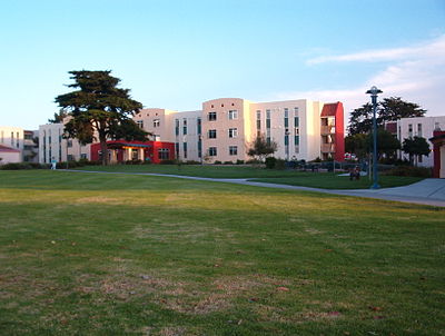
[[File:CSU Monterey Bay 2003.jpg|thumb|right|200px|[[California State University, Monterey Bay]] (CSUMB) campus]] |
|||
The age distribution was 30.2% under the age of 18, 11.1% from 18 to 24, 34.4% from 25 to 44, 15.8% from 45 to 64, and 8.5% 65 or older. The median age was 30 years. For every 100 females, there were 103.7 males. For every 100 females age 18 and over, there were 101.6 males. |
|||
The median [[income]] for a household in the city was $41,393, and the median family income was $43,259. Males had a median income of $29,204 versus $26,424 for females. The per capita income for the city was $15,183. About 9.3% of families and 12.1% of the population were below the [[poverty line]], including 14.9% of those under age 18 and 7.4% of those age 65 or over. |
|||
==Education== |
|||
[[Seaside High School (California)|Seaside High School]] is home to the 2006 CCS Small-Division Football Championship winners, the Spartans, led by coaches Alfred Avila, Quentin Crosby, Michael Drain, Jeff Quenga, Matt Avila, Pastor Joe Kamp, and Bryan Shaw. The football game between county rival [[Monterey High School (Monterey, California)|Monterey High School]] attracts nearly 5,000 people every year. [[Ron Rivera]], head coach of the NFL's [[Washington Commanders]] and former linebacker for the [[Chicago Bears]], was a 1980 graduate of Seaside High School. |
|||
[[California State University, Monterey Bay]] is located in Seaside near [[Fort Ord]] and is the second newest campus after [[California State University, Channel Islands|CSU Channel Islands]]. Seaside is also home to [[Monterey College of Law]], a private law school. |
|||
[[Monterey Peninsula College]] has public safety training center in Seaside that includes a fire and police academy. |
|||
==Economy== |
|||
The [[Defense Manpower Data Center]] has an office in Seaside, on the former Fort Ord. |
|||
==Scribble Hill== |
|||
Scribble Hill (also known as "Message Mountain") is part of Seaside's [[popular culture]]. It is a large sand dune near the junction of Fremont Boulevard and [[California State Route 1|State Route 1]], technically in [[Sand City, California|Sand City]], but adjacent to Seaside High School. People write messages on the dune with [[Carpobrotus edulis|ice plant]].<ref>{{Cite web | url=http://www.montereycountyweekly.com/news/local_news/sand-city-dune-inspires-public-declarations/article_72cd02dc-6b5e-5b10-960f-514939727c86.html | title=Sand City dune inspires public declarations}}</ref> It is a popular place for birthday messages, wedding proposals, and congratulation messages. Many people climb atop it to view [[fireworks]] on July 4. It is also known as "The Big Dune" or "The Dune" or "The Big Sand Hill" or "The Sand Board". |
|||
==Bayonet and Black Horse golf courses== |
|||
Bayonet Golf Course, designed in 1954, was built on the Fort Ord military base. It was named after the Army's 7th Infantry division. The course was allegedly designed to play to then-commanding officer Major General [[Robert B. McClure]]'s terrible slice, and thus has a series of holes nicknamed "Combat Corner" with substantial doglegs. Black Horse, named after the 11th Cavalry, followed in 1964. Until 1997, the golf courses were only open to members of the military; in 1997 it was purchased by the City of Seaside and opened to the public.<ref name="Bayonet and Black Horse Golf Course: History">[http://www.bayonetblackhorse.com/subpage.php?page_id=21 Bayonet and Black Horse: History]</ref> After several years of renovation, the courses now meet USGA specifications, and have one new and eight redesigned holes.<ref name="Bayonet and Black Horse Golf Course: Renovation">[http://www.bayonetblackhorse.com/subpage.php?page_id=22&page_name=Renovation Bayonet and Black Horse: Renovation]</ref> In 2012, these two courses hosted the PGA Professional National Championship<ref name="PGA Professional National Championship"/> Both Bayonet and Black Horse overlook Monterey Bay, and are par 72 courses.<ref name="Monterey County Convention and Visitors Bureau: Bayonet and Black Horse">[http://members.montereyinfo.org/bayonetblackhorsegoldcourse/ Monterey County Convention & Visitors Bureau: Bayonet and Black Horse]</ref> |
|||
==Notable people== |
|||
* [[Jamaree Bouyea]], basketball player |
|||
* [[Tony Curtis (American football)|Tony Curtis]], professional football player |
|||
* [[Herman Edwards]], football coach |
|||
* [[Mason Foster]], professional football player<ref>{{Cite web|url=http://www.buccaneers.com/team/roster/Mason-Foster/3ea0237b-e1b6-44af-b956-14a78a1eb333|title=Mason Foster player profile|publisher=Tampa Bay Buccaneers|access-date=September 18, 2014}}</ref> |
|||
* [[Mike Gravel]], [[U.S. senator]] from Alaska<ref>{{cite news |title=Mike Gravel, Former US Senator for Alaska, Dies at 91 |url=https://www.usnews.com/news/politics/articles/2021-06-27/mike-gravel-former-us-senator-for-alaska-dies-at-91 |magazine=U.S. News & World Report |date=June 27, 2021 |agency=Associated Press}}</ref><ref>{{cite news | url=https://www.nytimes.com/2019/06/06/magazine/mike-gravel-teens-twitter-presidential-campaign.html | title=Why Is Mike Gravel Running for President? (And Is He?) | first=Jamie Lauren | last=Keiles | magazine=[[The New York Times Magazine]] | date=June 9, 2019 | pages=22–27}}</ref> |
|||
* [[Charley Harraway]], professional football player |
|||
* [[Melvin T. Mason]], city councilman and 1984 presidential candidate (SWP)<ref>{{Cite book|title=Racial beachhead : diversity and democracy in a military town : Seaside, California|last=McKibben|first=Carol Lynn|date=2012|publisher=Stanford University Press|isbn=978-0804778442|location=Stanford, Calif.|oclc=762325021}}</ref> |
|||
* [[Rachel Roy]], fashion designer |
|||
==References== |
|||
{{reflist}} |
|||
==External links== |
|||
{{Wikivoyage|Seaside (California)|Seaside}} |
|||
* {{Official website}} |
|||
{{Monterey Bay Area}} |
|||
{{Cities of Monterey County, California}} |
{{Cities of Monterey County, California}} |
||
{{Monterey Peninsula Golf}} |
|||
{{authority control}} |
|||
[[Category:Cities in California]] |
|||
[[Category:Coastal towns in California]] |
|||
[[Category:Monterey County, California]] |
|||
[[Category:Towns in California]] |
|||
[[Category:Cities in Monterey County, California]] |
|||
[[de:Seaside]] |
|||
[[Category:Monterey Bay]] |
|||
[[Category:Populated coastal places in California]] |
|||
[[Category:Populated places established in 1888]] |
|||
[[Category:1888 establishments in California]] |
|||
[[Category:Populated places established in 1954]] |
|||
[[Category:1954 establishments in California]] |
|||
[[Category:Incorporated cities and towns in California]] |
|||
Latest revision as of 15:26, 16 May 2024
Seaside, California | |
|---|---|
 Post office in Seaside | |
 Flag Seal | |
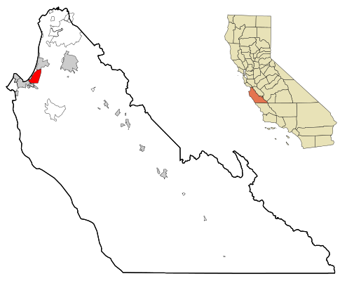 Location in Monterey County and the state of California | |
 Seaside Location in the United States | |
| Coordinates: 36°36′40″N 121°50′41″W / 36.61111°N 121.84472°W | |
| Country | United States |
| State | California |
| County | Monterey |
| Founded | 1888[1] |
| Incorporated | October 13, 1954[2] |
| Government | |
| • Mayor | Ian Oglesby[3] |
| • Senate | Bill Monning (D) |
| • Assembly | Mark Stone (D) |
| • U. S. Congress | Jimmy Panetta (D)[4] |
| Area | |
| • Total | 9.06 sq mi (23.5 km2) |
| • Land | 8.92 sq mi (23.1 km2) |
| • Water | 0.14 sq mi (0.4 km2) 1.51% |
| Elevation | 33 ft (10 m) |
| Population | |
| • Total | 32,366 |
| • Density | 3,627.3/sq mi (1,400.5/km2) |
| Time zone | UTC-8 (PST) |
| • Summer (DST) | UTC-7 (PDT) |
| ZIP code | 93955 |
| Area code | 831 |
| FIPS code | 06-70742 |
| GNIS feature ID | 1659619 |
| Website | www |
Seaside, formerly East Monterey, is a city in Monterey County, California, United States, with a population of 32,366 as of the 2020 census.[7] It is located 2.25 miles (3.6 km) east-northeast of Monterey,[8] at an elevation of 33 feet (10 m),[6] and is the home of California State University, Monterey Bay (CSUMB), UC MBEST Center, and the Monterey College of Law, which are located on the site of the former military base Fort Ord. Also on the site are the Bayonet and Black Horse golf courses, now open to the public and host to PGA Tour events,[9] including the 2012 PGA Professional National Championship.[10] Seaside is the gateway to Fort Ord National Monument, created on April 20, 2012.
History[edit]

In 1888 Seaside, then called East Monterey, was laid out by Dr. J.L.D. Roberts as a resort community.[8] The Seaside post office opened in 1891.[8] Seaside was incorporated in 1954[8] with Jack Oldemeyer as its first mayor.[11] In the mid-1960s, over a quarter of the population (6,000 out of 22,000) was African-American, which was the largest concentration of African-Americans between San Francisco and Los Angeles.[12]
Geography[edit]
Seaside is located at 36°36′40″N 121°50′41″W / 36.61111°N 121.84472°W,[6] toward the southern end of Monterey Bay. It is bordered to the north by Marina, to the west by Sand City, to the southwest by Monterey, and to the south by Del Rey Oaks. The California State Route 1 freeway runs along the western border of the city, north of Sand City.
According to the United States Census Bureau, the city of Seaside has a total area of 9.1 square miles (24 km2), of which 8.9 square miles (23 km2) are land and 0.1 square miles (0.3 km2), or 1.51%, are water.[5] According to the maps of the United States Geological Survey, the elevation ranges from 0 to 165 meters (0 to 541 feet).
Climate[edit]
The climate is a cool Mediterranean type, strongly influenced by the prevailing winds from the west, which blow over the Pacific Coast's cool ocean currents from Alaska. At the nearest National Weather Service Climate Station, in the City of Monterey at 385 feet (117 m) elevation: The coldest month is January, with an average daily high of 59.9 °F (15.5 °C); the warmest month is September, with an average daily high of 72 °F (22 °C); the average daily low is 43 °F (6 °C) in January and 52.7 °F (11.5 °C) in September; and the average rainfall is 20 inches (51 centimeters) per year, with 90.3% falling during November through April. The weather can be much hotter when the winds blow from the east: Since 1906, there have been 11 days with a high of 100 °F (38 °C) or higher; all 11 days occurred in June, September, or October.[13]
This region experiences warm (but not hot) and dry summers, with no average monthly temperatures above 71.6 °F (22.0 °C). According to the Köppen Climate Classification system, Seaside has a warm-summer Mediterranean climate, abbreviated "Csb" on climate maps.[14]
| Climate data for Seaside, California | |||||||||||||
|---|---|---|---|---|---|---|---|---|---|---|---|---|---|
| Month | Jan | Feb | Mar | Apr | May | Jun | Jul | Aug | Sep | Oct | Nov | Dec | Year |
| Mean daily maximum °F (°C) | 59.7 (15.4) |
60.9 (16.1) |
61.5 (16.4) |
62.6 (17.0) |
64.4 (18.0) |
67.0 (19.4) |
68.0 (20.0) |
69.4 (20.8) |
70.0 (21.1) |
68.3 (20.2) |
64.1 (17.8) |
60.0 (15.6) |
64.7 (18.2) |
| Mean daily minimum °F (°C) | 41.3 (5.2) |
43.5 (6.4) |
44.8 (7.1) |
46.3 (7.9) |
49.3 (9.6) |
51.7 (10.9) |
53.6 (12.0) |
54.2 (12.3) |
52.8 (11.6) |
49.5 (9.7) |
44.9 (7.2) |
41.3 (5.2) |
47.8 (8.8) |
| Average precipitation inches (mm) | 3.66 (93) |
3.20 (81) |
3.21 (82) |
1.29 (33) |
0.43 (11) |
0.19 (4.8) |
0.08 (2.0) |
0.11 (2.8) |
0.26 (6.6) |
0.91 (23) |
2.13 (54) |
2.42 (61) |
17.89 (454.2) |
| Source: [15][16] | |||||||||||||
Law and government[edit]
The City of Seaside is a General Law City with a Council/Manager form of government. The five-member City Council is a legislative and policy-making body that is elected on a nonpartisan basis to represent the residents of Seaside.
The City Manager is appointed by the City Council to manage the daily operations of the city and is responsible for making policy recommendations to the City Council and implementing City Council policy directives.
Policy decisions are made at City Council meetings, which are held on the first and third Thursdays of each month at 5:00 p.m. in the City Council Chambers at City Hall, with special meetings as needed. At these public meetings, the City Council makes policy determinations; approves agreements and contracts; adopts ordinances (local laws) and regulations; and authorizes the expenditure of City funds. The City Council also serves as the board of directors for the Redevelopment Agency of the City Council. Meetings of the Redevelopment Agency are held in concurrence with the City Council Meetings.[17]
Demographics[edit]
| Census | Pop. | Note | %± |
|---|---|---|---|
| 1960 | 19,353 | — | |
| 1970 | 36,883 | 90.6% | |
| 1980 | 36,567 | −0.9% | |
| 1990 | 38,901 | 6.4% | |
| 2000 | 31,696 | −18.5% | |
| 2010 | 33,025 | 4.2% | |
| 2020 | 32,366 | −2.0% | |
| U.S. Decennial Census[18] | |||
2010[edit]
At the 2010 census Seaside had a population of 33,025. The population density was 3,522.5 inhabitants per square mile (1,360.0/km2). The racial makeup of Seaside was 15,978 (48.4%) White, 2,783 (8.4%) African American, 347 (1.1%) Native American, 3,206 (9.7%) Asian, 529 (1.6%) Pacific Islander, 7,579 (22.9%) from other races, and 2,603 (7.9%) from two or more races. Hispanic or Latino of any race were 14,347 persons (43.4%).[19]
The census reported that 31,898 people (96.6% of the population) lived in households, 1,127 (3.4%) lived in non-institutionalized group quarters, and no one was institutionalized.
There were 10,093 households, 4,408 (43.7%) had children under the age of 18 living in them, 5,232 (51.8%) were opposite-sex married couples living together, 1,433 (14.2%) had a female householder with no husband present, 708 (7.0%) had a male householder with no wife present. There were 727 (7.2%) unmarried opposite-sex partnerships, and 70 (0.7%) same-sex married couples or partnerships. 1,927 households (19.1%) were one person and 697 (6.9%) had someone living alone who was 65 or older. The average household size was 3.16. There were 7,373 families (73.1% of households); the average family size was 3.57.
The age distribution was 8,923 people (27.0%) under the age of 18, 4,428 people (13.4%) aged 18 to 24, 10,154 people (30.7%) aged 25 to 44, 6,675 people (20.2%) aged 45 to 64, and 2,845 people (8.6%) who were 65 or older. The median age was 30.6 years. For every 100 females, there were 100.5 males. For every 100 females age 18 and over, there were 99.8 males.
There were 10,872 housing units at an average density of 1,159.6 per square mile, of the occupied units 4,183 (41.4%) were owner-occupied and 5,910 (58.6%) were rented. The homeowner vacancy rate was 2.2%; the rental vacancy rate was 4.9%. 11,979 people (36.3% of the population) lived in owner-occupied housing units and 19,919 people (60.3%) lived in rental housing units.
2000[edit]
At the 2000 census there were 31,696 people in 9,833 households, including 7,394 families, in the city. The population density was 3,591.3 inhabitants per square mile (1,386.6/km2). There were 11,005 housing units at an average density of 1,246.9 per square mile (481.4/km2). The racial makeup of the city was 49.21% White, 12.61% African American, 1.04% Native American, 10.09% Asian, 1.29% Pacific Islander, 18.41% from other races, and 7.34% from two or more races. Hispanic or Latino of any race were 34.48%.[20]
Of the 9,833 households 42.2% had children under the age of 18 living with them, 54.8% were married couples living together, 13.9% had a female householder with no husband present, and 24.8% were non-families. 18.1% of households were one person and 6.7% were one person aged 65 or older. The average household size was 3.21 and the average family size was 3.59.
The age distribution was 30.2% under the age of 18, 11.1% from 18 to 24, 34.4% from 25 to 44, 15.8% from 45 to 64, and 8.5% 65 or older. The median age was 30 years. For every 100 females, there were 103.7 males. For every 100 females age 18 and over, there were 101.6 males.
The median income for a household in the city was $41,393, and the median family income was $43,259. Males had a median income of $29,204 versus $26,424 for females. The per capita income for the city was $15,183. About 9.3% of families and 12.1% of the population were below the poverty line, including 14.9% of those under age 18 and 7.4% of those age 65 or over.
Education[edit]
Seaside High School is home to the 2006 CCS Small-Division Football Championship winners, the Spartans, led by coaches Alfred Avila, Quentin Crosby, Michael Drain, Jeff Quenga, Matt Avila, Pastor Joe Kamp, and Bryan Shaw. The football game between county rival Monterey High School attracts nearly 5,000 people every year. Ron Rivera, head coach of the NFL's Washington Commanders and former linebacker for the Chicago Bears, was a 1980 graduate of Seaside High School.
California State University, Monterey Bay is located in Seaside near Fort Ord and is the second newest campus after CSU Channel Islands. Seaside is also home to Monterey College of Law, a private law school.
Monterey Peninsula College has public safety training center in Seaside that includes a fire and police academy.
Economy[edit]
The Defense Manpower Data Center has an office in Seaside, on the former Fort Ord.
Scribble Hill[edit]
Scribble Hill (also known as "Message Mountain") is part of Seaside's popular culture. It is a large sand dune near the junction of Fremont Boulevard and State Route 1, technically in Sand City, but adjacent to Seaside High School. People write messages on the dune with ice plant.[21] It is a popular place for birthday messages, wedding proposals, and congratulation messages. Many people climb atop it to view fireworks on July 4. It is also known as "The Big Dune" or "The Dune" or "The Big Sand Hill" or "The Sand Board".
Bayonet and Black Horse golf courses[edit]
Bayonet Golf Course, designed in 1954, was built on the Fort Ord military base. It was named after the Army's 7th Infantry division. The course was allegedly designed to play to then-commanding officer Major General Robert B. McClure's terrible slice, and thus has a series of holes nicknamed "Combat Corner" with substantial doglegs. Black Horse, named after the 11th Cavalry, followed in 1964. Until 1997, the golf courses were only open to members of the military; in 1997 it was purchased by the City of Seaside and opened to the public.[22] After several years of renovation, the courses now meet USGA specifications, and have one new and eight redesigned holes.[23] In 2012, these two courses hosted the PGA Professional National Championship[10] Both Bayonet and Black Horse overlook Monterey Bay, and are par 72 courses.[24]
Notable people[edit]
- Jamaree Bouyea, basketball player
- Tony Curtis, professional football player
- Herman Edwards, football coach
- Mason Foster, professional football player[25]
- Mike Gravel, U.S. senator from Alaska[26][27]
- Charley Harraway, professional football player
- Melvin T. Mason, city councilman and 1984 presidential candidate (SWP)[28]
- Rachel Roy, fashion designer
References[edit]
- ^ Clark, Donald Thomas (1991) Monterey County Place Names. Carmel Valley, Calif.: Kestrel Press. p. 476. ISBN 1-880478-01-3
- ^ "California Cities by Incorporation Date". California Association of Local Agency Formation Commissions. Archived from the original (Word) on November 3, 2014. Retrieved August 25, 2014.
- ^ "Mayor & City Council". City of Seaside, CA. Retrieved September 18, 2014.
- ^ "California's 19th Congressional District - Representatives & District Map". Civic Impulse, LLC. Retrieved September 24, 2014.
- ^ a b "2022 U.S. Gazetteer Files: California". United States Census Bureau. Retrieved November 14, 2022.
- ^ a b c U.S. Geological Survey Geographic Names Information System: Seaside, California
- ^ a b "P1. Race – Seaside city, California: 2020 DEC Redistricting Data (PL 94-171)". U.S. Census Bureau. Retrieved November 14, 2022.
- ^ a b c d Durham, David L. (1998). California's Geographic Names: A Gazetteer of Historic and Modern Names of the State. Clovis, Calif.: Word Dancer Press. p. 958. ISBN 1-884995-14-4.
- ^ "Bayonet Golf Course". montereyinfo.org. Retrieved May 16, 2015.
- ^ a b "2015 PGA Professional National Championship at the Philadelphia Cricket Club, Philadelphia, Pennsylvania - PGA.com". PGA.com. Retrieved May 16, 2015.
- ^ "Past Mayors". Seaside, California government website. Retrieved December 2, 2021.
- ^ Ludlow, Lynn (May 28, 1967). "Seaside - the Next Watts?". The San Francisco Examiner – via Newspapers.com.
- ^ For the Period of Record, 1906-2012, per the Western Regional Climate Center, www.wrcc.dri.edu
- ^ "Seaside, California Köppen Climate Classification (Weatherbase)". Weatherbase. Retrieved May 16, 2015.
- ^ "Zipcode 93955". www.plantmaps.com. Retrieved July 28, 2023.
- ^ "Climate in Seaside, California". www.bestplaces.net. Retrieved July 28, 2023.
- ^ City of Seaside Web Page.http://www.ci.seaside.ca.us/index.aspx?page=55
- ^ "Census of Population and Housing". Census.gov. Retrieved June 4, 2015.
- ^ "2010 Census Interactive Population Search: CA - Seaside city". U.S. Census Bureau. Archived from the original on July 15, 2014. Retrieved July 12, 2014.
- ^ "U.S. Census website". United States Census Bureau. Retrieved January 31, 2008.
- ^ "Sand City dune inspires public declarations".
- ^ Bayonet and Black Horse: History
- ^ Bayonet and Black Horse: Renovation
- ^ Monterey County Convention & Visitors Bureau: Bayonet and Black Horse
- ^ "Mason Foster player profile". Tampa Bay Buccaneers. Retrieved September 18, 2014.
- ^ "Mike Gravel, Former US Senator for Alaska, Dies at 91". U.S. News & World Report. Associated Press. June 27, 2021.
- ^ Keiles, Jamie Lauren (June 9, 2019). "Why Is Mike Gravel Running for President? (And Is He?)". The New York Times Magazine. pp. 22–27.
- ^ McKibben, Carol Lynn (2012). Racial beachhead : diversity and democracy in a military town : Seaside, California. Stanford, Calif.: Stanford University Press. ISBN 978-0804778442. OCLC 762325021.
External links[edit]
| Bodies of water & submarine features |  | |
|---|---|---|
| Counties | ||
| Major cities | ||
| Cities and towns 50k-100k | ||
| Cities and towns 25k-50k | ||
| Cities, towns, and census-designated places <25k | ||
| Ghost towns | ||
Municipalities and communities of Monterey County, California, United States | ||
|---|---|---|
| Cities |  | |
| CDPs | ||
| Unincorporated communities |
| |
| CCDs | ||
| Ghost towns | ||
| Footnotes | ‡This populated place also has portions in an adjacent county | |
| International | |
|---|---|
| National | |
| Geographic | |
| Other | |