South Bucks: Difference between revisions
HotIceCream (talk | contribs) Tags: Mobile edit Mobile web edit |
Aoeuidhtns (talk | contribs) Infobox: Remove some template links which would only work for current local authorities. |
||
| (31 intermediate revisions by 20 users not shown) | |||
| Line 1: | Line 1: | ||
{{Short description|Former non-metropolitan district in England}} |
|||
{{Use dmy dates|date=February 2017}} |
{{Use dmy dates|date=February 2017}} |
||
{{Use British English|date=February 2017}} |
{{Use British English|date=February 2017}} |
||
{{About|the former local government district|the former UK Parliament constituency|South Buckinghamshire (UK Parliament constituency)}} |
|||
{{Infobox settlement |
{{Infobox settlement |
||
<!-- See {{Infobox settlement}} for the full list of available fields --> |
<!-- See {{Infobox settlement}} for the full list of available fields --> |
||
| Line 22: | Line 24: | ||
| government_type = Non-metropolitan district council |
| government_type = Non-metropolitan district council |
||
| leader_title = Leadership |
| leader_title = Leadership |
||
| leader_title1 = [[List of MPs elected in the United Kingdom general election |
| leader_title1 = [[List of MPs elected in the 2015 United Kingdom general election|MPs]] |
||
| established_title1 = Incorporated |
| established_title1 = Incorporated |
||
| population_density_km2 = auto |
| population_density_km2 = auto |
||
| Line 31: | Line 33: | ||
<!-- Elements unique to this article --> |
<!-- Elements unique to this article --> |
||
| official_name = South Bucks District |
| official_name = South Bucks District |
||
| image_skyline = |
| image_skyline = South Bucks District Council Offices.jpg |
||
| imagesize = |
| imagesize = |
||
| image_alt = |
| image_alt = |
||
| image_caption = |
| image_caption = Capswood, Oxford Road, Denham: South Bucks District Council headquarters 2004-2020. |
||
| image_shield = |
| image_shield = |
||
| shield_size = |
| shield_size = |
||
| Line 48: | Line 50: | ||
| established_date1 = 1 April 1974 |
| established_date1 = 1 April 1974 |
||
| governing_body = South Bucks District Council |
| governing_body = South Bucks District Council |
||
| leader_party = |
| leader_party = |
||
| leader_name = Leader & Cabinet |
| leader_name = Leader & Cabinet |
||
| leader_name1 = |
| leader_name1 = |
||
| area_total_km2 = 141.28 |
| area_total_km2 = 141.28 |
||
| population_total = 70,043 |
|||
| area_rank = {{English district area rank|GSS=E07000006}} [[List of English districts by area|(of {{English district total}})]] |
|||
| population_as_of = mid-2018 |
|||
| population_total = {{English district population|GSS=E07000006}} |
|||
| |
| population_rank = |
||
| population_rank = {{English district rank|GSS=E07000006}} [[List of English districts by population|(of {{English district total}})]] |
|||
| population_blank1 = 89.3% White<br>6.0% S.Asian<br>1.6% Black<br>1.4% Chinese or Other<br>1.7% Mixed Race |
| population_blank1 = 89.3% White<br>6.0% S.Asian<br>1.6% Black<br>1.4% Chinese or Other<br>1.7% Mixed Race |
||
| blank1_info = 11UE (ONS)<br />E07000006 (GSS) |
| blank1_info = 11UE (ONS)<br />E07000006 (GSS) |
||
| Line 61: | Line 62: | ||
| website = {{URL|www.southbucks.gov.uk}} |
| website = {{URL|www.southbucks.gov.uk}} |
||
}} |
}} |
||
'''South Bucks''' |
'''South Bucks''' was one of four [[Non-metropolitan district|local government districts]] in the [[non-metropolitan county]] of [[Buckinghamshire]], in [[South East England]]. |
||
The district was formed on 1 April 1974 by the [[Local Government Act 1972]], by the amalgamation of the area of [[Beaconsfield Urban District]] with part of [[Eton Rural District]]. The district was originally named '''Beaconsfield''' |
The district was formed on 1 April 1974 by the [[Local Government Act 1972]], by the amalgamation of the area of [[Beaconsfield Urban District]] with part of [[Eton Rural District]]. The district was originally named '''Beaconsfield'''; it was renamed to South Bucks on 1 April 1980, following the passing of a resolution by the district council.<ref>{{London Gazette |issue=48075 |date=23 January 1980 |page=1130 }}</ref> The name was formally 'South Bucks' rather than 'South [[Buckinghamshire]]'. The district was abolished on 31 March 2020 and its area is now administered by the unitary [[Buckinghamshire Council]]. |
||
:''See [[List of civil parishes in Buckinghamshire#South Bucks|List of civil parishes in South Bucks]].'' |
:''See [[List of civil parishes in Buckinghamshire#South Bucks|List of civil parishes in South Bucks]].'' |
||
{{seealso|South Bucks District Council elections}} |
|||
{{Infobox legislature|website={{URL|https://www.southbucks.gov.uk}}|structure1=File:South Bucks District Council.svg|structure1_res=280|house_type=Non-Metropolitan District|last_election1=[[2015 South Bucks District Council election|7 May 2015]]|leader1=Nick Naylor|leader2=John Read|leader1_type=Leader of the Council|leader2_type=Deputy Leader of the Council|party1=[[Conservative Party (UK)|Conservative]]|party2=[[Conservative Party (UK)|Conservative]]|political_groups1=; Administration |
|||
: {{nowrap|{{Color box|{{party color|Conservative Party (UK)}}|border=darkgray}} [[Conservative Party (UK)|Conservative]] (26)}} |
|||
; Other parties |
|||
: {{Color box|{{party color|Independent}}|border=darkgray}} [[Independent politician|Independent]] (2)|name=South Bucks District Council|next_election1=7 May 2021 (as part of Buckinghamshire Council)|seats=28 councillors|term_length=4 years}} |
|||
==Transport== |
==Transport== |
||
A large part of the district |
A large part of the district was sandwiched between the [[M40 motorway|M40]] and [[M4 motorway|M4]] motorways, both of which had junctions within the district. The major M40/[[M25 motorway|M25]] interchange is located near Gerrards Cross and is the M25's only junction in the district. South Bucks contained the greatest length of motorway in any Buckinghamshire district. |
||
Railway lines follow the motorways: they |
Railway lines follow the motorways: they were the [[Great Western Main Line]] and the [[Chiltern Main Line]], with important stations in [[Beaconsfield railway station (Buckinghamshire)|Beaconsfield]] and [[Gerrards Cross railway station|Gerrards Cross]]. [[Denham Aerodrome]] in the southeast of the district had a small number of chartered flights running out of it. |
||
==Premises== |
|||
==Council composition== |
|||
From its creation in 1974 until 2004 the council was based at the former Eton Rural District Council's offices on Windsor Road in [[Slough]], outside the district's administrative area. In 2004 the council moved to a modern office building at Capswood, Oxford Road, [[Denham, Buckinghamshire|Denham]], within its administrative area. Since the local government reorganisation in 2020, the building at Capswood serves as one of the area offices of [[Buckinghamshire Council]]. |
|||
{{As of| April 2019}} the council comprises:<ref>{{cite web | title = South Bucks - Your Councillors | publisher = South Bucks District | url = http://www.sbdc-spider.southbucks.gov.uk/mgMemberIndex.aspx?VW=TABLE&PIC=1&FN= | accessdate = 2015-07-08}}</ref> |
|||
*[[Conservative Party (UK)| Conservatives]] - 26 |
|||
*[[Independent (politican)|Independent]] - 1 |
|||
*[[The Independent Group|The Independent Group - Change UK]] - 1 |
|||
==Education== |
==Education== |
||
{{expand section|date=January 2014}} |
{{expand section|date=January 2014}} |
||
The Japanese international boarding school [[Teikyo School United Kingdom]] is located in [[Wexham]], South Bucks.<ref name=HeadWelc>"[http://www.teikyofoundation.com/english/index.html Head's Welcome]." ([https://archive. |
The Japanese international boarding school [[Teikyo School United Kingdom]] is located in [[Wexham]], South Bucks.<ref name=HeadWelc>"[http://www.teikyofoundation.com/english/index.html Head's Welcome]." ([https://archive.today/20140109030323/http://www.teikyofoundation.com/english/index.html Archive]) [[Teikyo School United Kingdom]]. Retrieved on 8 January 2014. "Framewood Road, Wexham, Buckinghamshire SL2 4QS UK"</ref> |
||
The former district was also home to comprehensive [[Beaconsfield School]] as well as the grammar schools, [[Beaconsfield High School]] and [[Burnham Grammar School]]. |
|||
== References == |
== References == |
||
{{Portal| |
{{Portal|South East England}} |
||
{{reflist}} |
{{reflist}} |
||
{{Commons |
{{Commons category|South Bucks District|South Bucks}} |
||
{{South Bucks}} |
{{South Bucks}} |
||
{{Buckinghamshire}} |
|||
{{SE_England}} |
|||
{{Coord|51.5764|N|0.6390|W|source:dewiki_region:GB-BKM_type:landmark|format=dms|display=title}} |
{{Coord|51.5764|N|0.6390|W|source:dewiki_region:GB-BKM_type:landmark|format=dms|display=title}} |
||
[[Category:South Bucks District| ]] |
[[Category:South Bucks District| ]] |
||
[[Category:Former non-metropolitan districts of Buckinghamshire]] |
|||
[[Category:Local authorities adjoining the River Thames|Bucks, South]] |
[[Category:Local authorities adjoining the River Thames|Bucks, South]] |
||
[[Category: |
[[Category:Districts of England established in 1974]] |
||
[[Category: |
[[Category:2020 disestablishments in England]] |
||
Latest revision as of 12:38, 19 October 2023
South Bucks District | |
|---|---|
 Capswood, Oxford Road, Denham: South Bucks District Council headquarters 2004-2020. | |
 South Bucks shown within Buckinghamshire | |
| Sovereign state | United Kingdom |
| Constituent country | England |
| Region | South East England |
| Non-metropolitan county | Buckinghamshire |
| Status | Non-metropolitan district |
| Admin HQ | Denham |
| Incorporated | 1 April 1974 |
| Government | |
| • Type | Non-metropolitan district council |
| • Body | South Bucks District Council |
| • Leadership | Leader & Cabinet |
| Area | |
| • Total | 54.55 sq mi (141.28 km2) |
| Population (mid-2018) | |
| • Total | 70,043 |
| • Density | 1,300/sq mi (500/km2) |
| • Ethnicity | 89.3% White 6.0% S.Asian 1.6% Black 1.4% Chinese or Other 1.7% Mixed Race |
| Time zone | UTC0 (GMT) |
| • Summer (DST) | UTC+1 (BST) |
| ONS code | 11UE (ONS) E07000006 (GSS) |
| OS grid reference | TQ0486 |
| Website | www |
South Bucks was one of four local government districts in the non-metropolitan county of Buckinghamshire, in South East England.
The district was formed on 1 April 1974 by the Local Government Act 1972, by the amalgamation of the area of Beaconsfield Urban District with part of Eton Rural District. The district was originally named Beaconsfield; it was renamed to South Bucks on 1 April 1980, following the passing of a resolution by the district council.[1] The name was formally 'South Bucks' rather than 'South Buckinghamshire'. The district was abolished on 31 March 2020 and its area is now administered by the unitary Buckinghamshire Council.
South Bucks District Council | |
|---|---|
| Type | |
| Type | Non-Metropolitan District |
| Leadership | |
Leader of the Council | Nick Naylor, Conservative |
Deputy Leader of the Council | John Read, Conservative |
| Structure | |
| Seats | 28 councillors |
 | |
Political groups |
|
Length of term | 4 years |
| Elections | |
Last election | 7 May 2015 |
Next election | 7 May 2021 (as part of Buckinghamshire Council) |
| Website | |
| www | |
Transport[edit]
A large part of the district was sandwiched between the M40 and M4 motorways, both of which had junctions within the district. The major M40/M25 interchange is located near Gerrards Cross and is the M25's only junction in the district. South Bucks contained the greatest length of motorway in any Buckinghamshire district. Railway lines follow the motorways: they were the Great Western Main Line and the Chiltern Main Line, with important stations in Beaconsfield and Gerrards Cross. Denham Aerodrome in the southeast of the district had a small number of chartered flights running out of it.
Premises[edit]
From its creation in 1974 until 2004 the council was based at the former Eton Rural District Council's offices on Windsor Road in Slough, outside the district's administrative area. In 2004 the council moved to a modern office building at Capswood, Oxford Road, Denham, within its administrative area. Since the local government reorganisation in 2020, the building at Capswood serves as one of the area offices of Buckinghamshire Council.
Education[edit]
This section needs expansion. You can help by adding to it. (January 2014) |
The Japanese international boarding school Teikyo School United Kingdom is located in Wexham, South Bucks.[2]
The former district was also home to comprehensive Beaconsfield School as well as the grammar schools, Beaconsfield High School and Burnham Grammar School.
References[edit]
- ^ "No. 48075". The London Gazette. 23 January 1980. p. 1130.
- ^ "Head's Welcome." (Archive) Teikyo School United Kingdom. Retrieved on 8 January 2014. "Framewood Road, Wexham, Buckinghamshire SL2 4QS UK"
South Bucks District | ||
|---|---|---|
| Towns (component areas and hamlets) | 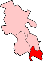 | |
| Other civil parishes (component villages and hamlets) | ||
| Former districts and boroughs | ||
| Former constituencies | ||