Temryuk: Difference between revisions
m r2.6.4) (robot Adding: diq:Temryuk |
+2010 Census preliminary results and some copyed |
||
| Line 1: | Line 1: | ||
{{Coord|45|16|N|37|23|E|type:city_region:RU|display=title}} |
{{Coord|45|16|N|37|23|E|type:city_region:RU|display=title}} |
||
| ⚫ | |||
| ⚫ | '''Temryuk''' ({{lang-ru|Темрю́к}}) is the largest [[types of inhabited localities in Russia|town]] and the [[administrative center]] of [[Temryuksky District]] of [[Krasnodar Krai]], [[Russia]], located on the [[Taman peninsula]] on the right bank of the [[Kuban River]] not far from its entry into the [[Temryuk Bay]], amid a field of [[mud volcano]]es. The [[seaport]] of Temryuk is situated {{convert|4|km|sp=us}} from the town itself. Population: {{ru-census2010|38,014|;}} {{ru-census2002|36,118|;}} {{su-census1989|33,163|;}} 26,600 (1975). |
||
| ⚫ | |||
| ⚫ | '''Temryuk''' ({{lang-ru|Темрю́к}}) is the largest [[types of inhabited localities in Russia|town]] |
||
Situated in the proximity of the site of ancient [[Tmutarakan]], Temryuk was vied by various powers as a vantage point commanding the mouth of the Kuban River. The first recorded settlement on the site was '''Tumnev''', a Tatar fortress, which passed to the [[Ghisolfi|Genoese merchants]] in the 14th century. It was known as '''Copa''' until occupied by the [[Khanate of Crimea]] in 1483. |
Situated in the proximity of the site of ancient [[Tmutarakan]], Temryuk was vied by various powers as a vantage point commanding the mouth of the Kuban River. The first recorded settlement on the site was '''Tumnev''', a Tatar fortress, which passed to the [[Ghisolfi|Genoese merchants]] in the 14th century. It was known as '''Copa''' until occupied by the [[Khanate of Crimea]] in 1483. |
||
Revision as of 17:22, 13 September 2011
45°16′N 37°23′E / 45.267°N 37.383°E
Temryuk (Russian: Темрю́к) is the largest town and the administrative center of Temryuksky District of Krasnodar Krai, Russia, located on the Taman peninsula on the right bank of the Kuban River not far from its entry into the Temryuk Bay, amid a field of mud volcanoes. The seaport of Temryuk is situated 4 kilometers (2.5 mi) from the town itself. Population: 38,014 (2010 Russian census);[1] 36,118 (2002 Census);[2] 33,163 (1989 Soviet census);[3] 26,600 (1975).
Situated in the proximity of the site of ancient Tmutarakan, Temryuk was vied by various powers as a vantage point commanding the mouth of the Kuban River. The first recorded settlement on the site was Tumnev, a Tatar fortress, which passed to the Genoese merchants in the 14th century. It was known as Copa until occupied by the Khanate of Crimea in 1483.
The Russians, allied with a local potentate, Temryuk of Kabarda, captured Tumnev and built a fortress of New Temryuk there. The Crimean Tatars retook the fort in 1570; it was known as Adis for a century to come. In the 18th century the site was settled by the Cossacks, whose stanitsa was incorporated as a town of Temryuk in 1860.
Gallery
-
Voennaya Gorka, a military vehicle museum on the slope of a mud vulcano in Temryuk.
-
A memorial devoted to the Defense of Temryuk during World War II
-
A WWII motor gun boat on exhibit at Voennaya Gorka
-
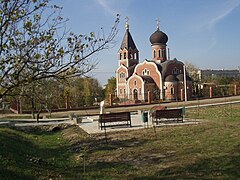
A local Orthodox church


References
- ^ Russian Federal State Statistics Service (2011). Всероссийская перепись населения 2010 года. Том 1 [2010 All-Russian Population Census, vol. 1]. Всероссийская перепись населения 2010 года [2010 All-Russia Population Census] (in Russian). Federal State Statistics Service.
- ^ Federal State Statistics Service (21 May 2004). Численность населения России, субъектов Российской Федерации в составе федеральных округов, районов, городских поселений, сельских населённых пунктов – районных центров и сельских населённых пунктов с населением 3 тысячи и более человек [Population of Russia, Its Federal Districts, Federal Subjects, Districts, Urban Localities, Rural Localities—Administrative Centers, and Rural Localities with Population of Over 3,000] (XLS). Всероссийская перепись населения 2002 года [All-Russia Population Census of 2002] (in Russian).
- ^ Всесоюзная перепись населения 1989 г. Численность наличного населения союзных и автономных республик, автономных областей и округов, краёв, областей, районов, городских поселений и сёл-райцентров [All Union Population Census of 1989: Present Population of Union and Autonomous Republics, Autonomous Oblasts and Okrugs, Krais, Oblasts, Districts, Urban Settlements, and Villages Serving as District Administrative Centers]. Всесоюзная перепись населения 1989 года [All-Union Population Census of 1989] (in Russian). Институт демографии Национального исследовательского университета: Высшая школа экономики [Institute of Demography at the National Research University: Higher School of Economics]. 1989 – via Demoscope Weekly.