Thorpe Cloud: Difference between revisions
Content deleted Content added
m rm tag - see talk |
Replacing geodata: {{coord|53.05604|N|1.77616|W|region:GB_source:enwiki-osgb36(SK151510)|display=title}} |
||
| Line 24: | Line 24: | ||
</gallery> |
</gallery> |
||
{{ |
{{coord|53.05604|N|1.77616|W|region:GB_source:enwiki-osgb36(SK151510)|display=title}}<!-- Note: WGS84 lat/long, converted from OSGB36 grid ref --> |
||
{{Derbyshire Places of interest}} |
{{Derbyshire Places of interest}} |
||
Revision as of 17:39, 19 September 2008
| Thorpe Cloud |
|---|
Thorpe Cloud is an isolated limestone hill (a reef knoll) lying between the villages of Thorpe and Ilam at the southern end of Dovedale. It is a popular hill amongst the many day-trippers who visit the area, and provides a fine viewpoint north up the dale and south across the Midland plain.
Like much of the dale, including Bunster Hill on the opposite bank, it is in the ownership of the National Trust, and is part of their South Peak Estate. These Dovedale properties were acquired by the Trust in 1934.
-
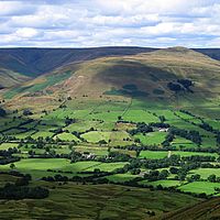
View from on the top of Thorpe Cloud looking towards Bunster Hill
-
From Thorpe Cloud looking to the left of Bunster Hill with the Car Park in the middle
-
View of Thorpe Cloud from Stepping Stones, Dovedale.

53°03′22″N 1°46′34″W / 53.05604°N 1.77616°W