Ukrina: Difference between revisions
Content deleted Content added
mNo edit summary |
m clean up using AWB |
||
| Line 46: | Line 46: | ||
| bridges = |
| bridges = |
||
}} |
}} |
||
'''Ukrina''' is a river in the [[Bosna|Central Bosnia]], [[Bosnia and Herzegovina]], right tributary of the river [[Sava |
'''Ukrina''' is a river in the [[Bosna|Central Bosnia]], [[Bosnia and Herzegovina]], right tributary of the river [[Sava|Save]]. Its mouth is 3 km north from settlement Koraće and 10 km southwest of [[Bosanski Brod]].<ref>http://www.kartabih.com/</ref> |
||
<ref name="ReferenceA">Vojnogeografski institut, Ed. (1955): Travnik (List karte 1:100.000, Izohipse na 20 m). Vojnogeografski institut, Beograd / Military Geographical Institute, Ed. (1955): Travnik (map sheet 1: 100,000, Contour lines at 20 m). Military Geographical Institute, Belgrade.</ref><ref name="Spahić M. 2000">Spahić M. et al. (2000): Bosna i Hercegovina (1:250.000). Izdavačko preduzeće „Sejtarija", Sarajevo., The Map</ref><ref name="Mučibabić B. 1998">Mučibabić B., Ed. (1998): Geografski atlas Bosne i Hercegovine. Geodetski zavod BiH, Sarajevo, ISBN 9958-766-00-0., pp: 4-5.</ref> |
<ref name="ReferenceA">Vojnogeografski institut, Ed. (1955): Travnik (List karte 1:100.000, Izohipse na 20 m). Vojnogeografski institut, Beograd / Military Geographical Institute, Ed. (1955): Travnik (map sheet 1: 100,000, Contour lines at 20 m). Military Geographical Institute, Belgrade.</ref><ref name="Spahić M. 2000">Spahić M. et al. (2000): Bosna i Hercegovina (1:250.000). Izdavačko preduzeće „Sejtarija", Sarajevo., The Map</ref><ref name="Mučibabić B. 1998">Mučibabić B., Ed. (1998): Geografski atlas Bosne i Hercegovine. Geodetski zavod BiH, Sarajevo, ISBN 9958-766-00-0., pp: 4-5.</ref> |
||
Ukrina is produced by the merging of the [[Mala Ukrina]] (Small Ukrina) and [[Velika Ukrina]] (Greart Ukrina]]. The length of Ukrina of origin Great Ukrina (Lukavac) is 119.3 |
Ukrina is produced by the merging of the [[Mala Ukrina]] (Small Ukrina) and [[Velika Ukrina]] (Greart Ukrina]]. The length of Ukrina of origin Great Ukrina (Lukavac) is 119.3 km, and the surface area of the basin is 1515.4 km². |
||
==See also== |
==See also== |
||
| Line 55: | Line 55: | ||
*[[Bosanski Brod]] |
*[[Bosanski Brod]] |
||
== |
==References== |
||
{{reflist}} |
{{reflist}} |
||
==External links== |
==External links== |
||
| ⚫ | |||
| ⚫ | |||
[[Category:Rivers of Bosnia and Herzegovina]] |
[[Category:Rivers of Bosnia and Herzegovina]] |
||
Revision as of 12:10, 2 April 2017
| Ukrina – Укрина | |
|---|---|
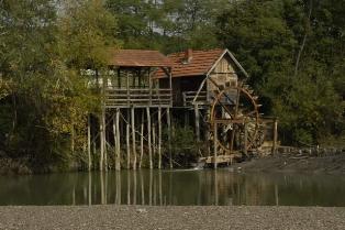 Watermill on Ukrina | |
 Ukrina river in Bosnia and Herzegovina | |
| Location | |
| Country | Bosnia and Herzegovina |
| Physical characteristics | |
| Source | |
| • elevation | ≈1,590 m (5,220 ft) |
| Mouth | |
• location | Sava, near Bosanski Brod |
• coordinates | 44°27′13″N 17°14′20″E / 44.453489°N 17.238850°E |
• elevation | 268 m (879 ft) |
| Length | 119.3 km (74.1 mi) |
| Basin size | 1,515.4 km2 (585.1 sq mi) |
| Width | |
| • minimum | Variable |
| Basin features | |
| River system | Black Sea |
| Waterfalls | Several |
Ukrina is a river in the Central Bosnia, Bosnia and Herzegovina, right tributary of the river Save. Its mouth is 3 km north from settlement Koraće and 10 km southwest of Bosanski Brod.[1] [2][3][4]
Ukrina is produced by the merging of the Mala Ukrina (Small Ukrina) and Velika Ukrina (Greart Ukrina]]. The length of Ukrina of origin Great Ukrina (Lukavac) is 119.3 km, and the surface area of the basin is 1515.4 km².
See also
References
- ^ http://www.kartabih.com/
- ^ Vojnogeografski institut, Ed. (1955): Travnik (List karte 1:100.000, Izohipse na 20 m). Vojnogeografski institut, Beograd / Military Geographical Institute, Ed. (1955): Travnik (map sheet 1: 100,000, Contour lines at 20 m). Military Geographical Institute, Belgrade.
- ^ Spahić M. et al. (2000): Bosna i Hercegovina (1:250.000). Izdavačko preduzeće „Sejtarija", Sarajevo., The Map
- ^ Mučibabić B., Ed. (1998): Geografski atlas Bosne i Hercegovine. Geodetski zavod BiH, Sarajevo, ISBN 9958-766-00-0., pp: 4-5.