Valparai
Valparai Booking 08903214470 | |
|---|---|
 View of a club ground in Valparai | |
| Country | |
| State | Tamil Nadu |
| District | Coimbatore |
| Government | |
| • Municipal Chairman | Dr.K.Balamurugan |
| Elevation | 1,193 m (3,914 ft) |
| Population (2011)[1] | |
| • Total | 70,859 |
| Languages | |
| • Official | Tamil |
| Time zone | UTC+5:30 (IST) |
| PIN | 642127 |
| Telephone code | 04253 |
| Vehicle registration | TN 41 |

Valparai is a Taluk and hill station in the Coimbatore district of Tamil Nadu,India. It is located 3,500 feet above sea level on the Anaimalai Hills range of the Western Ghats, at a distance of 100 km from Coimbatore and 65 km from Pollachi.There are 40 hairpin bends on the way up to Valparai from Azhiyar. While major portions of the land are owned by private tea companies, large forest areas continue to be out of bounds.[2] The Government of Tamil Nadu in collaboration with ITDC initiated Tourism promotion through infrastructure development including Resort hotels and Amusement parks to attract tourists.[3] As of 2011, the town had a population of 70,859.
Valparai Accommodation - 08903214470
Valparai is located at 10°22′N 76°58′E / 10.37°N 76.97°E. It has an average elevation of 1193 metres (3914 feet).[4]
Demographics
According to the 2011 census, Valparai had a population of 70,859 with a sex-ratio of 1,013 females for every 1,000 males, much above the national average of 929.[5] A total of 5,007 were under the age of six, constituting 2,564 males and 2,443 females. Scheduled Castes and Scheduled Tribes accounted for 59.68% and 1.75% of the population respectively. The average literacy of the town was 78.47%, compared to the national average of 72.99%.[5] The town had a total of 19,017 households. There were a total of 38,440 workers, comprising 107 cultivators, 4,828 main agricultural labourers, 173 in household industries, 29,338 other workers, 3,994 marginal workers, 71 marginal cultivators, 341 marginal agricultural labourers, 62 marginal workers in household industries and 3,520 other marginal workers.[6]
History
Earliest records of this area are from the year 1846 when Ramasamy Mudaliyar started coffee plantation here. In 1864, the Karnatic Coffee Company began their coffee plantation here but they could not make it profitable, hence they sold part of their land. In 1875, the roads and guest houses were built by soldiers for the visit of England’s Prince of Wales, the future Edward VII. Soldiers were posted here and horses and elephants were used for this purpose. However, the visit was eventually cancelled. In 1890, Mr W. Wintil and Mr Nordan bought a huge portion of land in Valparai from the Madras State Government under the British Raj. Wintil deforested the area and planted tea and coffee. He was assisted by Carwer Marsh, an experienced planter for a salary of 250 rupees. Carwer Marsh was hardworking and built a close relationship with the local people. He was later known as The Father of Anamalais. A statue of Carwer Marsh has been erected on the Kavarkal Estate.[7]
Route
Pollachi is the nearest town. Valparai is about 64 km from Pollachi, 80 km from Udumalai Taluk, now part of Tirupur district. The road from Pollachi to Valparai has 40 hairpin bends.
It takes about 2 hours to reach Valparai from Pollachi on State Highway 78.
TNSTC buses are operated from Udumalai and Palani.
The main route from Udumalai to Anamalai is the best road way to connect Valparai with Madurai and Trichy.
Valparai is connected to Athirampalli falls by road, but this is a complete Ghat Section, and you can travel only during the day between 9 am and 6 pm. This route is a completely adventurous trip, and you should see wild animals on the way. It is almost 130 km from Valparai to Chalakudi, but it takes around 4 hours as this is a Ghat road.
Places to Visit
mangalasamy
- Solaiyar Dam
- Balaji Temple
- Pancha Mugha Vinayakar Temple
- Monkey Falls
- Aaliyar Dam
- Athirampalli Falls
- Estates at both sides of the road
- Chinnakallar dam
- nallamudi poonjolai
- koolangal aaru
- waterfalls
Economy

The economy of Valparai depends on plantation crops. Valparai has a high concentration of tea and coffee estates. Most of the people living here work in these estates. Some of the major Plantation Companies are :[8][9]
- Tamil Nadu Tea Plantation Corporation (TNTPC)
- The Bombay Burmah Trading Corporation (MUDIS Group)
- Tata Tea Estates Ltd (Tata Tea)
- Tea Estates India Ltd (TEIL)
- Woodbriar Ltd (Stanmoore Group)
- Parry Agro Ltd
- N.E.P.C Tea Ltd
- Jayshree Tea Industries Ltd (Birla Group)
- Periya Karamalai Tea Estates Ltd
- Puthuthottam Tea Estate Ltd
- Waterfalls Tea Estate Ltd
- Booking Resorts Num 08903214470
Wildlife

Valparai is a mid-elevation hill station (Ootacamund is considerably higher). The tea plantations are surrounded by evergreen forest. The region is also a rich elephant tract and is known to have many leopards.[10]
The scenic drive to the town from Pollachi passes through the Indira Gandhi Wildlife Sanctuary noted for elephants, boars, lion-tailed macaques, gaur, spotted deer, sambar, and giant squirrels. The area is also rich in birds, including the great hornbill. Water bodies at Monkey Falls and Aliyar Dam are also seen en route. A famous place of worship, Balaji Temple also attracts pilgrims. Valparai receives among the highest rainfall in the region during the monsoons (around June).
The Valparai range is also habitat to the Nilgiri tahr, an endemic wild goat. These mountain goats inhabit the high ranges and prefer open terrain, cliffs and grass-covered hills, a habitat largely confined to altitudes from 1200 to 2600m in the southern Western Ghats. Their territory extended far and wide all along these hills in the past, but, because of hunting and large-scale habitat destruction, they now exist only in a few isolated sites like the Anaimalai Hills.[11]
The human-elephant conflict here is a delicate issue. The tea plantations are a hindrance to the movement of wildlife, particularly elephants who walk large distances to reach water bodies and feeding areas.[12]
On the way to Valparai you can see many wild animals like lion tailed monkeys, elephants, deer, wild goats. Natives of Valparai are often attacked by leopards and tigers; there are some attacks from the elephants also.

Politics
Valparai assembly constituency is a Scheduled Caste constituency and forms part of Pollachi Lok Sabha constituency.[13]
Images
-
Bar-winged flycatcher
-
-
Indian gaur also called a bison
-
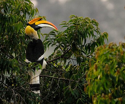
Malabar hornbill
-
-
Peahen in the early morning light
-
Pied hornbill
-
-
-


References
- ^ http://www.censusindia.gov.in/pca/SearchDetails.aspx?Id=706815
- ^ The Hindu MetroPlus dated 11 Dec'2004
- ^ Govt of Tamil Nadu Order
- ^ Falling Rain Genomics, Inc - Valparai
- ^ a b "Census Info 2011 Final population totals". Office of The Registrar General and Census Commissioner, Ministry of Home Affairs, Government of India. 2013. Retrieved 26 January 2014.
- ^ "Census Info 2011 Final population totals - Valparai". Office of The Registrar General and Census Commissioner, Ministry of Home Affairs, Government of India. 2013. Retrieved 26 January 2014.
- ^ Valparai Heavenly Hill Station
- ^ Valparaiinfo.com
- ^ Valparai
- ^ Dept of Forests, Govt of TN
- ^ The Hindu:Magazine 26 Feb 2006
- ^ The Hindu:MetroPlus 7 Aug 2006
- ^ "List of Parliamentary and Assembly Constituencies" (PDF). Tamil Nadu. Election Commission of India. Retrieved 11 October 2008.
External links
| District headquarters |  | |
|---|---|---|
| Country | ||
| State | ||
| Region | ||
| Taluks | ||
| Municipal corporations | ||
| Municipalities | ||
| Rivers | ||
| History | ||
| Places of interest |
| |
| Universities | ||