Zaporizhzhia: Difference between revisions
m minor corrections |
RodRabelo7 (talk | contribs) |
||
| (90 intermediate revisions by 61 users not shown) | |||
| Line 1: | Line 1: | ||
| ⚫ | |||
{{Short description|City and administrative centre of Zaporizhzhia Oblast, Ukraine}} |
{{Short description|City and administrative centre of Zaporizhzhia Oblast, Ukraine}} |
||
{{ |
{{other uses}} |
||
| ⚫ | |||
{{EngvarB|date=July 2018}} |
{{EngvarB|date=July 2018}} |
||
{{Use dmy dates|date= |
{{Use dmy dates|date=March 2024}} |
||
{{Infobox settlement |
{{Infobox settlement |
||
| name |
| name = |
||
| native_name |
| native_name = {{lang|uk|Запоріжжя}} |
||
| official_name |
| official_name = Zaporizhzhia |
||
| other_name |
| other_name = |
||
| |
| nickname = |
||
| translit_lang1 = [[Ukrainian language|Ukrainian]] |
|||
| translit_lang1_type1 |
| translit_lang1_type1 = [[Romanization of Ukrainian|National]]/[[BGN/PCGN romanization|"BGN/PCGN"]] |
||
| translit_lang1_info1 |
| translit_lang1_info1 = Zaporizhzhia |
||
| translit_lang1_type2 |
| translit_lang1_type2 = [[ALA-LC romanization|ALA-LC]] |
||
| translit_lang1_info2 |
| translit_lang1_info2 = Zaporiz͡hz͡hi͡a |
||
| translit_lang1_type3 |
| translit_lang1_type3 = [[Scientific transliteration of Cyrillic|Scholarly]] |
||
| translit_lang1_info3 |
| translit_lang1_info3 = Zaporižžja |
||
| ⚫ | |||
| translit_lang1_type4 = [[Scientific transliteration of Cyrillic|Scholarly]] |
|||
| ⚫ | |||
| translit_lang1_info4 = Zaporižžja --> |
|||
| ⚫ | |||
| ⚫ | |||
| photo1a = Нічний проспект.jpg |
| photo1a = Нічний проспект.jpg |
||
| photo2a = Січ з висоти польоту.jpg |
| photo2a = Січ з висоти польоту.jpg |
||
| Line 35: | Line 33: | ||
| foot_montage = |
| foot_montage = |
||
}} |
}} |
||
| image_caption |
| image_caption = ''From top to bottom and left to right'': {{hlist| |
||
* [[Sobornyi Avenue]] |
|||
* {{ill|Sobornyi Avenue|uk|Соборний проспект (Запоріжжя)|ru|Соборный проспект (Запорожье)}} |
|||
* {{ill|Zaporozka Sich Historical-Cultural Complex|uk|Історико-культурний комплекс «Запорозька Січ» |ru|Историко-культурный комплекс «Запорожская Сечь»}} |
* {{ill|Zaporozka Sich Historical-Cultural Complex|uk|Історико-культурний комплекс «Запорозька Січ» |ru|Историко-культурный комплекс «Запорожская Сечь»}} |
||
* {{ill|Zaporizhzhia Musical and Drama Theatre|uk|Запорізький академічний обласний український музично-драматичний театр імені Володимира Магара |ru|Запорожский академический областной украинский музыкально-драматический театр имени Владимира Магара}} |
* {{ill|Zaporizhzhia Musical and Drama Theatre|uk|Запорізький академічний обласний український музично-драматичний театр імені Володимира Магара |ru|Запорожский академический областной украинский музыкально-драматический театр имени Владимира Магара}} |
||
* {{ill|Festival Square|uk|Площа Фестивальна (Запоріжжя)|ru|Фестивальная площадь (Запорожье) |
* {{ill|Festival Square|uk|Площа Фестивальна (Запоріжжя)|ru|Фестивальная площадь (Запорожье)}} and the [[Governor of Zaporizhzhia Oblast|Zaporizhzhia Oblast Administrative Council]] |
||
* [[Dnieper Hydroelectric Station]] |
* [[Dnieper Hydroelectric Station]] |
||
* [[ |
* [[Zaporizhzhia International Airport]] |
||
* [[Slavutych-Arena|Slavutych Arena Stadium]] |
* [[Slavutych-Arena|Slavutych Arena Stadium]] |
||
* [[ |
* [[Zaporizhzhia-1 railway station]] |
||
}} |
}} |
||
| image_flag |
| image_flag = Прапор міста Запоріжжя (2003).svg |
||
| flag_size |
| flag_size = 100px |
||
| image_blank_emblem |
| image_blank_emblem = Емблема (логотип) Запоріжжя.png |
||
| image_shield |
| image_shield = Герб Запорожья 2003 года.svg |
||
| shield_size |
| shield_size = 80px |
||
| pushpin_map |
| pushpin_map = Ukraine Zaporizhzhia Oblast#Ukraine |
||
| pushpin_label_position |
| pushpin_label_position = right |
||
| pushpin_map_alt |
| pushpin_map_alt = |
||
| pushpin_map_caption |
| pushpin_map_caption = |
||
| pushpin_mapsize |
| pushpin_mapsize = |
||
| pushpin_label |
| pushpin_label = Zaporizhzhia |
||
| image_map |
| image_map = <!-- Контурная карта Запорожья Запорожской области.png --> |
||
| map_caption |
| map_caption = <!-- Zaporizhzhia Oblast (yellow) with the City of Zaporizhzhia (orange) --> |
||
|subdivision_type |
| subdivision_type = Country |
||
| subdivision_name |
| subdivision_name = {{Flagu|Ukraine}} |
||
| |
| subdivision_type1 = [[Oblasts of Ukraine|Oblast]] |
||
| |
| subdivision_name1 = [[Zaporizhzhia Oblast]] |
||
| |
| subdivision_type2 = [[Raions of Ukraine|Raion]] |
||
| |
| subdivision_name2 = [[Zaporizhzhia Raion]] |
||
| subdivision_type3 = [[Hromada]] |
|||
| parts_type = [[#Government and administrative divisions|Raions]] |
|||
| subdivision_name3 = [[Zaporizhzhia urban hromada]] |
|||
| ⚫ | |||
| |
| parts_type = [[#Government and administrative divisions|Raions]] |
||
| ⚫ | |||
| ⚫ | |||
| |
| parts = 7 |
||
| |
| p1 = [[Zavodskyi District, Zaporizhzhia|Zavodskyi District]] |
||
| |
| p2 = [[Khortytskyi District]] |
||
| |
| p3 = [[Komunarskyi District]] |
||
| |
| p4 = [[Dniprovskyi District, Zaporizhzhia|Dniprovskyi District]] |
||
| |
| p5 = [[Oleksandrivskyi District, Zaporizhzhia|Oleksandrivskyi District]] |
||
| |
| p6 = [[Voznesenskyi District, Zaporizhzhia|Voznesenskyi District]] |
||
| ⚫ | |||
| leader_name = [[Anatolii Kurtiev]] (acting Mayor since 30 September 2021)<ref>{{in lang|uk}} [https://www.pravda.com.ua/news/2021/09/30/7308863/ The mayor of Zaporozhye was fired], [[Ukrayinska Pravda]] (30 September 2021)</ref> |
|||
| leader_title = [[List of mayors of Zaporizhzhia|Mayor]] |
|||
| ⚫ | |||
| leader_name = {{ill|Rehina Kharchenko|uk|Харченко Регіна Владиславівна}} |
|||
| established_date = 952 |
|||
| ⚫ | |||
| ⚫ | |||
| |
| established_date = 1770 |
||
| ⚫ | |||
| area_total_km2 = 334 |
|||
| established_date2 = 1806 |
|||
| ⚫ | |||
| |
| area_total_km2 = 334 |
||
| |
| area_metro_km2 = 4675 |
||
| ⚫ | |||
| population_blank1_title = [[Ukrainian Census (2001)|2001]]<ref name=Census2001/> |
|||
| |
| population_total = 710052 |
||
| population_metro = 840866 |
|||
| population_density_km2 |
| population_density_km2 = 1365.2 |
||
| timezone = EET |
|||
| |
| timezone = EET |
||
| |
| utc_offset = +2 |
||
| |
| timezone_DST = EEST |
||
| utc_offset_DST = +3 |
|||
| coordinates |
| coordinates = {{coord|47|51|00|N|35|07|03|E|region:UA|display=inline,title}} |
||
| elevation_m = |
|||
| |
| elevation_m = |
||
| postal_code_type = Postal code |
|||
| postal_code = 69xxx |
|||
| |
| postal_code = 69xxx |
||
| |
| area_code = +380 61(2) |
||
| blank_name = [[Köppen climate classification|Climate]] |
|||
| blank_info |
| blank_info = [[Humid continental climate#Hot/warm summer subtype|Dfa]] |
||
| website |
| website = |
||
| pushpin_relief |
| pushpin_relief = y |
||
| module |
| module = |
||
| blank_emblem_type = Tourist logo (since 2017) |
|||
}} |
}} |
||
'''Zaporizhzhia'''<ref>{{cite web |date=28 August 2017 |title=Про затвердження транслітерації написання географічної назви міста Запоріжжя латиницею. Рішення виконавчого комітету №476 |url=https://zp.gov.ua/uk/documents/item/25339 |publisher=Zaporizhzhia city council. Executive committee}}</ref>{{refn|1=Also spelled as '''Zaporizhzhya''' or '''Zaporizhia'''|group=note}} ({{lang-uk|Запоріжжя}} |
'''Zaporizhzhia'''<ref>{{cite web |date=28 August 2017 |title=Про затвердження транслітерації написання географічної назви міста Запоріжжя латиницею. Рішення виконавчого комітету №476 |url=https://zp.gov.ua/uk/documents/item/25339 |publisher=Zaporizhzhia city council. Executive committee |access-date=20 January 2020 |archive-date=26 July 2020 |archive-url=https://web.archive.org/web/20200726072410/https://zp.gov.ua/uk/documents/item/25339 |url-status=live }}</ref>{{refn|1=Also spelled as '''Zaporizhzhya''' or '''Zaporizhia'''.|group=note}} ({{lang-uk|Запоріжжя}}, {{IPA|uk|zɐpoˈriʒʲːɐ|IPA|Uk-Запоріжжя.ogg}}; {{lang-ru|Запорожье|Zaporozhye}}, {{IPA|ru|zəpɐˈroʐje|IPA|Ru-Запорожье.ogg}}), formerly known as '''Oleksandrivsk''' until 1921,{{refn|1={{lang-ru|link=no|Александровск|Aleksandrovsk}}; {{lang-uk|Олександрівськ}}.|group=note}} is a city in southeast [[Ukraine]], situated on the banks of the [[Dnieper|Dnieper River]]. It is the [[Capital city|administrative centre]] of [[Zaporizhzhia Oblast]].<ref>{{in lang|uk}} [http://www.ukrstat.gov.ua/druk/publicat/kat_u/publ2_u.htm] {{Webarchive|url=https://web.archive.org/web/20210506154051/http://www.ukrstat.gov.ua/druk/publicat/kat_u/publ2_u.htm|date=6 May 2021}}</ref> Zaporizhzhia has a population of {{Ua-pop-est2022|710,052|.}} |
||
Zaporizhzhia is known for the historic island of [[Khortytsia]], multiple [[power station]]s and for being an important industrial centre. Steel, aluminium, aircraft engines, automobiles, transformers for substations, and other heavy industrial goods are produced in the region. |
Zaporizhzhia is known for the historic island of [[Khortytsia]], multiple [[power station]]s and for being an important industrial centre. Steel, aluminium, aircraft engines, automobiles, transformers for substations, and other heavy industrial goods are produced in the region. |
||
| Line 109: | Line 110: | ||
The name ''Zaporizhzhia'' refers to the position of the city: "beyond the rapids"—downstream or south of the [[Dnieper Rapids]]. These were previously an impediment to navigation and the site of important [[portage]]s. In 1932, the rapids were flooded to become part of the reservoir of the [[Dnieper Hydroelectric Station]].<ref name="Pospelov">Pospelov, pp. 25–26</ref> |
The name ''Zaporizhzhia'' refers to the position of the city: "beyond the rapids"—downstream or south of the [[Dnieper Rapids]]. These were previously an impediment to navigation and the site of important [[portage]]s. In 1932, the rapids were flooded to become part of the reservoir of the [[Dnieper Hydroelectric Station]].<ref name="Pospelov">Pospelov, pp. 25–26</ref> |
||
Before 1921, the city was called Aleksandrovsk (or Oleksandrivsk), named after the original fortress that formed a part of the |
Before 1921, the city was called Aleksandrovsk (or Oleksandrivsk), named after the original fortress that formed a part of the [[Dnipro Line|Dnieper Defence Line]] of the [[Russian Empire]]. |
||
==History== |
==History== |
||
{{Main|History of Zaporizhzhia}} |
{{Main|History of Zaporizhzhia}} |
||
Zaporizhzhia was founded in 1770, when the Aleksandrovskaya ({{lang|ru|Александровская}}) Fortress was built as a part of the Dnieper Defence Line, to protect the southern territories of the Russian Empire from [[Crimean Khanate|Crimean Tatar]] invasions.<ref name="Novistki-191">Я. П. Новицкий. [http://history.org.ua/LiberUA/Book/novits1/4.pdf История города Александровска, (Екатеринославской губ.) в связи с историей возникновения крепостей Днепровской линии 1770–1806 г.] – Екатеринослав: Типография Губернского Земства, 1905. – 176 с. {{in lang|ru}}</ref> Following the [[Treaty of Küçük Kaynarca]] in 1775, the southern lands of the Russian Plain and the Crimean peninsula were absorbed into the Russian Empire. The Aleksandrovskaya Fortress then lost its military significance, and became a small rural town, which from 1806 to around 1930 was called |
Zaporizhzhia was founded in 1770, when the Aleksandrovskaya ({{lang|ru|Александровская}}) Fortress was built as a part of the Dnieper Defence Line, to protect the southern territories of the Russian Empire from [[Crimean Khanate|Crimean Tatar]] invasions.<ref name="Novistki-191">Я. П. Новицкий. [http://history.org.ua/LiberUA/Book/novits1/4.pdf История города Александровска, (Екатеринославской губ.) в связи с историей возникновения крепостей Днепровской линии 1770–1806 г.] {{Webarchive|url=https://web.archive.org/web/20160303200710/http://history.org.ua/LiberUA/Book/novits1/4.pdf |date=3 March 2016 }} – Екатеринослав: Типография Губернского Земства, 1905. – 176 с. {{in lang|ru}}</ref> Following the [[Treaty of Küçük Kaynarca]] in 1775, the southern lands of the Russian Plain and the Crimean peninsula were absorbed into the Russian Empire. The Aleksandrovskaya Fortress then lost its military significance, and became a small rural town, which from 1806 to around 1930 was called Alexandrovsk.<ref name="Pospelov" /> |
||
The opening of the Kichkas Bridge at the start of 20th century, the first rail crossing of the [[Dnieper]], was followed the industrial growth of Zaporizhzhia |
The opening of the Kichkas Bridge at the start of the 20th century, the first rail crossing of the [[Dnieper]], was followed by the industrial growth of Zaporizhzhia.<ref name=Bridges>[http://www.zounb.zp.ua/resourse/scarbnicya/Adelberg/indexf.html ''The bridges of Zaporizhzhia'' (Мосты Запорожья)] {{Webarchive|url=https://web.archive.org/web/20120308145207/http://www.zounb.zp.ua/resourse/scarbnicya/Adelberg/indexf.html |date=8 March 2012 }}, by L. Adelberg (Адельберг Л), pub RA Tandem st, Zaporizhzhia, 2005. {{in lang|ru}}</ref> In 1916, during World War I, the [[Motor Sich|DEKA Stock Association]] transferred its aircraft engine manufacturing plant from [[Saint Petersburg]] to Zaporizhzhia.<ref name=meria.zp>[http://meria.zp.ua/test/index.php?id=5 ''Official Portal Zaporizhzhia city authorities, History'' (Офіційний портал, Запорізької міської влади, Історія міста)] {{webarchive |url=https://web.archive.org/web/20120121005919/http://meria.zp.ua/test/index.php?id=5 |date=21 January 2012}}, accessed 11 April 2011. {{in lang|uk}}</ref> |
||
During the [[Russian Civil War]] (1918{{ndash}}1921), Zaporizhzhia was the scene of fierce fighting between the Red Army and the White armies of [[Anton Denikin|Denikin]] and [[Pyotr Wrangel|Wrangel]], [[Symon Petliura|Petliura]]'s [[Ukrainian People's Army]] of the [[Ukrainian People's Republic]], and German-Austrian troops. The opposing armies used the strategically important Kichkas Bridge to transfer |
During the [[Russian Civil War]] (1918{{ndash}}1921), Zaporizhzhia was the scene of fierce fighting between the Red Army and the White armies of [[Anton Denikin|Denikin]] and [[Pyotr Wrangel|Wrangel]], [[Symon Petliura|Petliura]]'s [[Ukrainian People's Army]] of the [[Ukrainian People's Republic]], and German-Austrian troops. The opposing armies used the strategically important Kichkas Bridge to transfer troops, ammunition, and medical supplies. The Soviet government industrialized Zaporizhzhia still further during the 1920s and 1930s, when the Dnieper Hydroelectric Station, and the [[Zaporizhstal|Zaporizhzhia Steel Plant]], and the Dnieper Aluminium Plant were built.<ref>{{cite web |url=https://books.google.com/books?id=l-lNAAAAYAAJ |date=27 October 1969 |publisher=Искусство |via=Google Books |title=Sovetskai︠a︡ arkhitektura}}</ref><ref>[http://www.tsuab.ru/PUBLICATION/VESTNIK/2009/4/4-2009-06-meerovich.pdf Меерович М. Г. Соцгород – базовое понятие советской градостроительной теории первых пятилеток] {{webarchive |url=https://web.archive.org/web/20110928142629/http://www.tsuab.ru/PUBLICATION/VESTNIK/2009/4/4-2009-06-meerovich.pdf |date=28 September 2011}}</ref><ref>{{cite web |url=http://photoalbum.zp.ua/history/history/part2.htm |title=История Запорожья |website=photoalbum.zp.ua |access-date=11 April 2011 |archive-date=2 May 2008 |archive-url=https://web.archive.org/web/20080502150118/http://photoalbum.zp.ua/history/history/part2.htm |url-status=live }}</ref> In the 1930s, the American United Engineering and Foundry Company built a [[strip mill]] similar to the [[Ford River Rouge Complex|Ford River Rouge steel mill]] to produce rolling steel strip. The annual capacity of the mill reached {{convert|600000|ST|tonne|order=flip}} of {{convert|66|in|cm|abbr=in|order=flip}} wide steel.<ref name=Dunn-13>''The Soviet economy and the Red Army, 1930–1945'', by Walter Scott Dunn, Greenwood Publishing Group, 1995 {{ISBN|0-275-94893-5}}, page 13.</ref> |
||
===World War II (1941–1945)=== |
===World War II (1941–1945)=== |
||
[[File:ZaporizhiaCombat.jpg|thumb|A Red Army soldier near the [[Dnieper Hydroelectric Station|Dnieper hydro-electric dam]]]] |
[[File:ZaporizhiaCombat.jpg|thumb|left|A Red Army soldier near the [[Dnieper Hydroelectric Station|Dnieper hydro-electric dam]]]] |
||
| ⚫ | After the outbreak of the [[Eastern Front (World War II)|War between the USSR and Nazi Germany]] in June 1941, the [[Soviet government]] began evacuating Zaporizhzhia's industries to [[Siberia]].<ref name= zabor.zp.GPW>[http://www.zabor.zp.ua/zaporozhye/istoria_zaporozhye.htm The Great Patriotic War on the territory of Zaporizhzhia (Великая Отечественная война на территории Запорожья)] {{Webarchive|url=https://web.archive.org/web/20111220152909/http://www.zabor.zp.ua/zaporozhye/istoria_zaporozhye.htm |date=20 December 2011 }} {{in lang|ru}}</ref> and the Soviet security forces began shooting political prisoners in the city.<ref>''Germany and the Second World War, Volume IV The Attack on the Soviet Union'', by [[Horst Boog]], [[Jürgen Förster]], [[Joachim Hoffmann]], [[Ernst Klink]], [[Rolf-Dieter Müller]], [[Gerd R. Ueberschär]], pub Clarendon Press, 1998, {{ISBN|0-19-822886-4}}, p. 909.</ref> On 18 August 1941, elements of the [[1st Panzer Group|German 1st Panzergruppe]] reached the outskirts of Zaporizhzhia on the right bank and seized the island of Khortytsia.<ref>{{cite web |url=http://www.theeasternfront.co.uk/timeline1941.htm |title=The Eastern Front, Timeline 1941 |access-date=18 April 2011 |archive-url=https://web.archive.org/web/20110719023845/http://www.theeasternfront.co.uk/timeline1941.htm |archive-date=19 July 2011 |url-status=dead}}</ref> |
||
| ⚫ | The Red Army blew a {{convert|120 x 10|m|ft}} hole in the Dnieper hydroelectric dam on 18 August 1941, producing a flood wave that swept from Zaporizhzhia to [[Nikopol, Ukraine|Nikopol]].<ref name= zabor.zp.GPW/> The flood killed local residents as well as soldiers from both armies, with historians estimating a death toll between 20,000 and 100,000.<ref>[http://www.rferl.org/content/european-remembrance-day-ukraine-little-known-ww2-tragedy/25083847.html Radio Free Europe Radio Liberty] {{Webarchive|url=https://web.archive.org/web/20160922132634/http://www.rferl.org/content/european-remembrance-day-ukraine-little-known-ww2-tragedy/25083847.html |date=22 September 2016 }}, ''Ukrainian Activists Draw Attention To Little-Known WWII Tragedy '', by Dmytro Moroz and Claire Bigg, 23 August 2013.</ref> Despite reinforcements, Zaporizhzhia was taken on 3 October 1941.<ref>''Germany and the Second World War, Volume IV The Attack on the Soviet Union'', p. 607, says that Zaporizhzhia was captured on 1 October 1941.</ref> The German occupation lasted two years; during which the Germans shot over 35,000 people, and sent 58,000 people to Germany as [[forced labourer]]s.<ref name= zabor.zp.GPW/> |
||
| ⚫ | After the outbreak of the [[Eastern Front (World War II)|War between the USSR and Nazi Germany]] in June 1941, the [[Soviet government]] began evacuating Zaporizhzhia's industries to [[Siberia]].<ref name= zabor.zp.GPW>[http://www.zabor.zp.ua/zaporozhye/istoria_zaporozhye.htm The Great Patriotic War on the territory of Zaporizhzhia (Великая Отечественная война на территории Запорожья)] {{in lang|ru}}</ref> and the Soviet security forces began shooting political prisoners in the city.<ref>''Germany and the Second World War, Volume IV The Attack on the Soviet Union'', by [[Horst Boog]], [[Jürgen Förster]], [[Joachim Hoffmann]], [[Ernst Klink]], [[Rolf-Dieter Müller]], [[Gerd R. Ueberschär]], pub Clarendon Press, 1998, {{ISBN|0-19-822886-4}}, p 909.</ref> On 18 August 1941, elements of the [[1st Panzer Group|German 1st Panzergruppe]] reached the outskirts of Zaporizhzhia on the right bank and seized the island of Khortytsia.<ref>{{cite web |url=http://www.theeasternfront.co.uk/timeline1941.htm |title=The Eastern Front, Timeline 1941 |access-date=18 April 2011 |archive-url=https://web.archive.org/web/20110719023845/http://www.theeasternfront.co.uk/timeline1941.htm |archive-date=19 July 2011 |url-status=dead}}</ref> |
||
| ⚫ | The Germans reformed [[Army Group South]] in February 1943, and put its headquarters in Zaporizhzhia.<ref>''Lost Victories'', by Field Marshal Eric von Manstein, translated by Anthony G Powell, [http://www.nazi.org.uk/military%20pdfs3/ErichVonManstein-LostVictories-WarMemoirsOfHitlersMostBrilliantGeneral.pdf pdf version p267-270].</ref> [[Adolf Hitler]] visited the headquarters in February 1943, and again the following month, where he was briefed by Field Marshal [[Eric von Manstein]] and his air force counterpart Field Marshal [[Wolfram Freiherr von Richthofen]], and in September 1943,<ref>''Lost Victories'', by Field Marshal Eric von Manstein, pdf version p290-2.</ref> the month the Army Group moved its headquarters to [[Kropyvnytskyi|Kirovohrad]].<ref name=Manstein301>''Lost Victories'', by Field Marshal Eric von Manstein, says that the Germans finished repairing the railway bridge only a few months before they lost the city in October 1943.</ref> |
||
| ⚫ | The Red Army blew a {{convert|120 x 10|m|ft}} hole in the Dnieper hydroelectric dam on 18 August 1941, producing a flood wave that swept from Zaporizhzhia to [[Nikopol, Ukraine|Nikopol]].<ref name= zabor.zp.GPW/> The flood killed local residents as well as soldiers from both armies, with historians estimating |
||
| ⚫ | In August 1943, the Germans built the [[Panther-Wotan line|Panther-Wotan]] defence line along the Dnieper from [[Kyiv]] to [[Crimea]]. They retreated back to this line in September 1943, holding the city as a bridgehead over the Dnieper with elements of 40th Panzer and 17th Corps.<ref name=Timeline1943>{{cite web |url=http://www.theeasternfront.co.uk/timeline1943.htm |title=The Eastern Front, Timeline 1943 |access-date=18 April 2011 |archive-url=https://web.archive.org/web/20110719024008/http://www.theeasternfront.co.uk/timeline1943.htm |archive-date=19 July 2011 |url-status=dead}}</ref> The Soviet [[Southwestern Front (Soviet Union)|Southwestern Front]], commanded by [[Army General (Soviet Union)|Army General]] [[Rodion Malinovsky]], attacked Zaporizhzhia on 10 October 1943.<ref name=Timeline1943/> The defenders repelled these attacks, but the Red Army launched a surprise night attack on 13 October, which succeeded in reclaiming most parts of the city.<ref name=Lelyushenko>[http://militera.lib.ru/memo/russian/lelyushenko_dd/index.html ''Moscow-Stalingrad-Berlin-Prague, Memories of Army Commander'' ("Москва-Сталінград-Берлін-Прага". Записки командарма)] {{Webarchive|url=https://web.archive.org/web/20130515115811/http://militera.lib.ru/memo/russian/lelyushenko_dd/index.html |date=15 May 2013 }}, by Dmitri Danilovich Lelyushenko (Лелюшенко Дмитро Данилович), pub Nauka, Moscow, 1987, chapter 4.</ref> |
||
| ⚫ | The Germans reformed [[Army Group South]] in February 1943, and put its headquarters in Zaporizhzhia.<ref>''Lost Victories'', by Field Marshal Eric von Manstein, translated by Anthony G Powell, [http://www.nazi.org.uk/military%20pdfs3/ErichVonManstein-LostVictories-WarMemoirsOfHitlersMostBrilliantGeneral.pdf pdf version p267-270].</ref> [[Adolf Hitler]] visited the headquarters in |
||
| ⚫ | In August 1943, the Germans built the [[Panther-Wotan line|Panther-Wotan]] defence line along the Dnieper from [[Kyiv]] to [[Crimea]]. They retreated back to this line in September 1943, holding the city as a bridgehead over the Dnieper with elements of 40th Panzer and 17th Corps.<ref name=Timeline1943>{{cite web |url=http://www.theeasternfront.co.uk/timeline1943.htm |title=The Eastern Front, Timeline 1943 |access-date=18 April 2011 |archive-url=https://web.archive.org/web/20110719024008/http://www.theeasternfront.co.uk/timeline1943.htm |archive-date=19 July 2011 |url-status=dead}}</ref> The Soviet [[Southwestern Front (Soviet Union)|Southwestern Front]], commanded by [[Army General (Soviet Union)|Army General]] [[Rodion Malinovsky]], attacked Zaporizhzhia on 10 October 1943.<ref name=Timeline1943/> The defenders repelled these attacks, but the Red Army launched a surprise night attack on 13 October, which succeeded in reclaiming most parts of the city.<ref name=Lelyushenko>[http://militera.lib.ru/memo/russian/lelyushenko_dd/index.html ''Moscow-Stalingrad-Berlin-Prague, Memories of Army Commander'' ("Москва-Сталінград-Берлін-Прага". Записки командарма)], by Dmitri Danilovich Lelyushenko (Лелюшенко Дмитро Данилович), pub Nauka, Moscow, 1987, chapter 4.</ref> |
||
===1991–present=== |
===1991–present=== |
||
[[File:Запоріжжя. Проспект Леніна, 175 (фото Alexey Tolmachov, 2015).jpg|thumb|Modern Zaporizhzhia (2015)]] |
[[File:Запоріжжя. Проспект Леніна, 175 (фото Alexey Tolmachov, 2015).jpg|thumb|Modern Zaporizhzhia (2015)]] |
||
| ⚫ | In 2004, to alleviate congestion around the [[Zaporizhzhia Arch Bridge]] area, construction began on the [[New Zaporizhzhia Dniper Bridge]], although construction was halted soon after it began, due to a lack of funding.<ref>{{Cite web |url=https://fakty.ictv.ua/ru/videos/chomu-mosty-buduyut-po-14-rokiv-i-shho-kazhe-ukravtodor |title=Почему мосты строят по 14 лет – и что говорит Укравтодор |access-date=4 July 2018 |archive-date=13 August 2018 |archive-url=https://web.archive.org/web/20180813055939/https://fakty.ictv.ua/ru/videos/chomu-mosty-buduyut-po-14-rokiv-i-shho-kazhe-ukravtodor/ |url-status=live }}</ref> |
||
| ⚫ | During the [[2014 Euromaidan regional state administration occupations]], during protests against President [[Viktor Yanukovych]],<ref>{{cite news |last=Buckley |first=Neil |title=Ukraine protests spread to Yanukovich heartland |url=https://www.ft.com/content/0be4a86e-86b0-11e3-aa31-00144feab7de |url-access=subscription |website=Financial Times |date=26 January 2014 |access-date=27 October 2018 |archive-date=16 November 2018 |archive-url=https://web.archive.org/web/20181116121244/https://www.ft.com/content/0be4a86e-86b0-11e3-aa31-00144feab7de |url-status=live }}</ref> Zaporizhzhia's [[Local government in Ukraine|regional state administration]] building was occupied by 4,500 protesters,<ref>{{cite news |url=http://www.unian.net/politics/888801-v-zaporoje-uchastniki-maydana-opechatali-kabinetyi-rukovodstva-zaporojskoy-oga.html |title=В Запорожье участники Майдана опечатали кабинеты руководства Запорожской ОГА : Новости УНИАН |agency=Ukrainian Independent Information Agency |access-date=24 February 2014 |archive-date=26 February 2014 |archive-url=https://web.archive.org/web/20140226165807/http://www.unian.net/politics/888801-v-zaporoje-uchastniki-maydana-opechatali-kabinetyi-rukovodstva-zaporojskoy-oga.html |url-status=live }}</ref> and there were clashes between Ukrainian and [[2014 pro-Russian unrest in Ukraine|pro-Russian activists]] in April 2014.<ref>[http://www.businessweek.com/news/2014-04-13/ukraine-s-eastern-tension-turns-deadly-in-worst-case-scenario Ukraine Tensions Escalate as Russia, U.S. Exchange Barbs] {{webarchive |url=https://web.archive.org/web/20140915022529/http://www.businessweek.com/news/2014-04-13/ukraine-s-eastern-tension-turns-deadly-in-worst-case-scenario |date=15 September 2014 }}</ref> |
||
| ⚫ | In 2004, to alleviate congestion around the [[Zaporizhzhia Arch Bridge]] area, construction began on the [[New Zaporizhzhia Dniper Bridge]], although construction was halted soon after it began, due to a lack of funding.<ref> |
||
| ⚫ | During the [[2014 Euromaidan regional state administration occupations]], during protests against President [[Viktor Yanukovych]],<ref>{{cite news |url=https://www.ft.com/content/0be4a86e-86b0-11e3-aa31-00144feab7de | |
||
On 19 May 2016, the [[Verkhovna Rada]] approved the "[[Decommunization in Ukraine|Decommunisation Law]]".<ref name=decommupbbcUZap>[http://www.pravda.com.ua/news/2015/05/15/7068057/ Poroshenko signed the laws about decommunization]. [[ |
On 19 May 2016, the [[Verkhovna Rada]] approved the "[[Decommunization in Ukraine|Decommunisation Law]]".<ref name=decommupbbcUZap>[http://www.pravda.com.ua/news/2015/05/15/7068057/ Poroshenko signed the laws about decommunization] {{Webarchive|url=https://web.archive.org/web/20160423181130/http://www.pravda.com.ua/news/2015/05/15/7068057/ |date=23 April 2016 }}. [[Ukrainska Pravda]]. 15 May 2015<br>[http://en.interfax.com.ua/news/general/265988.html Poroshenko signs laws on denouncing Communist, Nazi regimes] {{Webarchive|url=https://web.archive.org/web/20180802040659/http://en.interfax.com.ua/news/general/265988.html |date=2 August 2018 }}, [[Interfax-Ukraine]]. 15 May 20<br>[https://www.bbc.com/news/world-europe-32267075 Goodbye, Lenin: Ukraine moves to ban communist symbols] {{Webarchive|url=https://web.archive.org/web/20160307200441/http://www.bbc.co.uk/news/world-europe-32267075 |date=7 March 2016 }}, [[BBC News]] (14 April 2015)</ref> Since the introduction of the law, the city council renamed over 50 streets and administrative areas of the city,{{refn|1=Since modern Zaporizhiazhia was greatly enlarged in the [[Soviet Union]], many typography in the city had to be renamed. In the year of the fall of the [[Russian Empire]] (1917), the population of Alexandrovsk was about 60,000 people. In the year of [[Declaration of Independence of Ukraine|Ukraine's declaration of independence]] (1991), the city's population reached almost 1 million people.|group=note}} monuments of the [[List of leaders of the Soviet Union|Soviet Union leaders]] [[Lenin]] and [[Felix Dzerzhinsky]] have been destroyed,<ref name="Ukraineremoves36396854">{{citation |title=In pictures: Ukraine removes communist-era symbols |url=https://www.bbc.com/news/world-europe-36396854 |publisher=BBC News |author=Vitaly Shevchenko |date=1 June 2016 |access-date=30 September 2021 |archive-date=27 December 2019 |archive-url=https://web.archive.org/web/20191227005200/https://www.bbc.com/news/world-europe-36396854 |url-status=live }}</ref><ref>{{Cite web |url=http://zabor.zp.ua/www/content/polnyi-perechen-pereimenovannykh-v-zaporozhe-ulits |title=Полный перечень переименованных в Запорожье улиц |access-date=9 July 2018 |archive-date=5 December 2019 |archive-url=https://web.archive.org/web/20191205152412/http://zabor.zp.ua/www/content/polnyi-perechen-pereimenovannykh-v-zaporozhe-ulits |url-status=live }}</ref> and names honouring Soviet leaders in the titles of industrial plants, factories, culture centres, and the [[DniproHES]] have been removed.<ref>{{in lang|uk}} [http://www.radiosvoboda.org/a/news/27682492.html In Zaporizhzhia began to "dekomunize" DniproGES] {{Webarchive|url=https://web.archive.org/web/20210930104119/https://www.radiosvoboda.org/a/news/27682492.html |date=30 September 2021 }}, [[Radio Free Europe]] (4 April 2016)</ref> |
||
====Russian invasion (2022)==== |
====Russian invasion (2022)==== |
||
{{further| |
{{further|2022 bombing of Zaporizhzhia}} |
||
[[File:Zaporizhzhia after Russian shelling, 2023-03-22 (01).webp|thumb|Residential buildings in Zaporizhzhia after Russian missile strikes on 22 March 2023]] |
|||
Russian forces have been engaged in ongoing attacks on Zaporizhzhia since the beginning of the [[2022 Russian invasion of Ukraine]]. On 27 February, fighting was reported in the southern outskirts,<ref>{{cite |
Russian forces have been engaged in ongoing attacks on Zaporizhzhia since the beginning of the [[2022 Russian invasion of Ukraine]]. On 27 February, fighting was reported in the southern outskirts,<ref>{{cite news |title=Техніка росіян зайшла до Бердянська, в Запоріжжі зброю дають усім готовим захищати обласний центр |url=https://www.radiosvoboda.org/a/news-rosijany-v-berdyansku-zaporizhzhia-teroborona/31726585.html |access-date=28 February 2022 |website=Радіо Свобода |date=27 February 2022 |language=uk |archive-date=27 February 2022 |archive-url=https://web.archive.org/web/20220227161249/https://www.radiosvoboda.org/a/news-rosijany-v-berdyansku-zaporizhzhia-teroborona/31726585.html |url-status=live |last=Свобода |first=Радіо}}</ref> and Russian forces began shelling the city later that evening.<ref>{{cite web |title=Жителів Запоріжжя просять не покидати укриття: Обстрілюють аеродром – новини Запоріжжя |url=https://zp.depo.ua/ukr/zp/zhiteliv-zaporizhzhya-prosyat-ne-pokidati-ukrittya-obstrilyuyut-aerodrom-202202271429691 |access-date=28 February 2022 |website=www.depo.ua |language=uk |archive-date=27 February 2022 |archive-url=https://web.archive.org/web/20220227221029/https://zp.depo.ua/ukr/zp/zhiteliv-zaporizhzhya-prosyat-ne-pokidati-ukrittya-obstrilyuyut-aerodrom-202202271429691 |url-status=live}}</ref> Russia [[Russian occupation of Zaporizhzhia Oblast|invaded and occupied part of Zaporizhzhia Oblast]] but failed to take Zaporizhzhia itself. On 3 March, Russian forces approached the [[Zaporizhzhia Nuclear Power Plant]], raising concerns about a potential nuclear meltdown.<ref name="NPR110322">{{cite news |title=Video analysis reveals Russian attack on Ukrainian nuclear plant veered near disaster |url=https://www.npr.org/2022/03/11/1085427380/ukraine-nuclear-power-plant-zaporizhzhia |access-date=1 April 2022 |publisher=NPR |date=11 March 2022 |archive-date=1 April 2022 |archive-url=https://web.archive.org/web/20220401111417/https://www.npr.org/2022/03/11/1085427380/ukraine-nuclear-power-plant-zaporizhzhia |url-status=live }}</ref><ref>"Update 1-Ukraine nuclear power plant Zaporizhzhia on fire, town mayor says". Reuters. 4 March 2022. Retrieved 7 March 2022.</ref> Russian military forces fired missiles on Zaporizhzhia on the evening of 12/13 May.<ref>{{cite web |url=https://www.ukrinform.net/rubric-ato/3482044-invaders-fire-missiles-on-zaporizhzhia-sumy-region-at-night.html |title=Invaders fire missiles on Zaporizhzhia, Sumy region at night |date=13 May 2022 |access-date=16 May 2022 |archive-date=16 May 2022 |archive-url=https://web.archive.org/web/20220516004811/https://www.ukrinform.net/rubric-ato/3482044-invaders-fire-missiles-on-zaporizhzhia-sumy-region-at-night.html |url-status=live }}</ref> |
||
On 30 September, hours before Russia formally [[Annexation of Southern and Eastern Ukraine|annexed Southern and Eastern Ukraine]], the Russian Armed Forces [[Russian attack on civilian convoy in Zaporizhzhia|launched |
On 30 September, hours before Russia formally [[Annexation of Southern and Eastern Ukraine|annexed Southern and Eastern Ukraine]], the Russian Armed Forces [[Russian attack on civilian convoy in Zaporizhzhia|launched S-300 missiles at a civilian convoy in Zaporizhzhia]], killing at least 30 people.<ref name="bbc">{{cite news |date=30 September 2022 |title=Ukraine war: Survivors speak of horror as Zaporizhzhia convoy hit |language=en-GB |publisher=BBC News |url=https://www.bbc.com/news/world-europe-63086697 |access-date=30 September 2022 |archive-date=1 October 2022 |archive-url=https://web.archive.org/web/20221001130611/https://www.bbc.com/news/world-europe-63086697 |url-status=live }}</ref> On 9 October, Russian forces [[Zaporizhzhia residential building airstrike|launched rockets]] at residential buildings, killing at least 17 people.<ref>{{cite news |date=9 October 2022 |title=At least 17 are killed in Zaporizhzhia |work=[[The New York Times]] |url=https://www.nytimes.com/live/2022/10/09/world/russia-ukraine-war-news#at-least-17-civilians-killed-in-overnight-missile-attack-on-zaporizhzhia |url-status=live |access-date=9 October 2022 |archive-url=https://web.archive.org/web/20221009122024/https://www.nytimes.com/live/2022/10/09/world/russia-ukraine-war-news#at-least-17-civilians-killed-in-overnight-missile-attack-on-zaporizhzhia |archive-date=9 October 2022}}</ref> |
||
==Geography== |
==Geography== |
||
Zaporizhzhia is located in south-eastern [[Ukraine]]. The Dnieper splits the city in two; between them is Khortytsia Island. The city covers {{cvt|334|km2}} at an elevation of {{cvt|50|m}} above sea level.<ref>{{cite web |url=http://photoalbum.zp.ua/passport/history/ |title=Паспорт города Запорожье |website=photoalbum.zp.ua}}</ref> The New and Old Dnieper flow past around Khortytsia: The {{ill|New Dnieper|uk|Новий Дніпро}} is about {{convert|800|m|ft|abbr=in}} wide while the {{ill|Old Dnieper|uk|Старий Дніпро (Запоріжжя)}} is about {{convert|200|m|ft|abbr=in}} wide. The island |
Zaporizhzhia is located in south-eastern [[Ukraine]]. The Dnieper splits the city in two; between them is [[Khortytsia|Khortytsia Island]]. The city covers {{cvt|334|km2}} at an elevation of {{cvt|50|m}} above sea level.<ref>{{cite web |url=http://photoalbum.zp.ua/passport/history/ |title=Паспорт города Запорожье |website=photoalbum.zp.ua |access-date=15 April 2011 |archive-date=2 October 2022 |archive-url=https://web.archive.org/web/20221002112336/http://photoalbum.zp.ua/passport/history/ |url-status=live }}</ref> The New and Old Dnieper flow past around Khortytsia: The {{ill|New Dnieper|uk|Новий Дніпро}} is about {{convert|800|m|ft|abbr=in}} wide while the {{ill|Old Dnieper|uk|Старий Дніпро (Запоріжжя)}} is about {{convert|200|m|ft|abbr=in}} wide. The island size is {{cvt|12|x|2|km|mi}}. Smaller rivers in the city also enter the Dnieper: {{ill|Sukha Moskovka|lt=Sukha|uk|Суха Московка}} and {{ill|Mokra Moskovka|uk|Мокра Московка}}, {{ill|Kushuhum River|lt=Kushuhum|uk|Кушугум (річка)}}, and {{ill|Verkhnia Khortytsia|uk|Верхня Хортиця (річка)}}. |
||
The flora of Khortytsia is unique and diverse, due to the dry [[steppe]] air and a large freshwater basin, which cleans the air polluted by industry. The island is a [[national park]]. The ground surface is cut by large ravines ("{{lang|uk|balka}}"), hiking routes and historical monuments. The island, which is a popular recreational area, has[[ |
The flora of Khortytsia is unique and diverse, due to the dry [[steppe]] air and a large freshwater basin, which cleans the air polluted by industry. The island is a [[national park]]. The ground surface is cut by large ravines ("{{lang|uk|balka}}"), hiking routes and historical monuments. The island, which is a popular recreational area, has [[sanatorium]]s, resorts, health centres, and sandy beaches.<ref>{{cite web |url=http://www.gis-center.com/khort_cgi/main_page.html |title=The interactive map of island of Khortitsa (Russian) |access-date=2 July 2011 |archive-url=https://web.archive.org/web/20110702035741/http://www.gis-center.com/khort_cgi/main_page.html |archive-date=2 July 2011 |url-status=dead}}</ref> |
||
===Climate=== |
===Climate=== |
||
| Line 295: | Line 295: | ||
==Governance== |
==Governance== |
||
{{see also|List of mayors of Zaporizhzhia}} |
{{see also|List of mayors of Zaporizhzhia}} |
||
Zaporizhzhia is the main city of [[Zaporizhzhia Oblast]] with a form of self-rule within the oblast. The city is divided into 7 |
Zaporizhzhia is the main city of [[Zaporizhzhia Oblast]] with a form of self-rule within the oblast. The city is divided into 7 [[Urban districts of Ukraine|urban districts]]. |
||
{| class="center" "toccolours" style="float:right; font-size:100%; margin-left:10px" |
{| class="center" "toccolours" style="float:right; font-size:100%; margin-left:10px" |
||
|+ <big></big> |
|+ <big></big> |
||
| style="padding-left:1em;" | |
| style="padding-left:1em;" | |
||
<br> |
<br> |
||
The population of the districts of the city of |
The population of the districts of the city of Zaporizhzhia as of 1 November 2015:<ref name="Naselennya">[http://www.zp.ukrstat.gov.ua/images/stories/Exp_dem_2421.pdf Головне управління статистики в Запорізькій області — Чисельність населення м. Запоріжжя] {{Webarchive|url=https://web.archive.org/web/20190213123652/http://www.zp.ukrstat.gov.ua/images/stories/Exp_dem_2421.pdf |date=13 February 2019 }} |
||
на 1 листопада 2015 року]</ref> |
на 1 листопада 2015 року]</ref> |
||
{| class="wikitable sortable" |
{| class="wikitable sortable" |
||
| Line 306: | Line 306: | ||
! № !! Raion !! Population !! Percent of Total |
! № !! Raion !! Population !! Percent of Total |
||
|- |
|- |
||
| 1 || |
| 1 || Oleksandrivskyi || 68,666 || 9.06 |
||
|- |
|- |
||
| 2 || |
| 2 || [[Zavodskyi District, Zaporizhzhia|Zavodskyi]] || 50,750 || 6.7 |
||
|- |
|- |
||
| 3 || |
| 3 || [[Komunarskyi District|Komunarskyi]] || 133,752 || 17.64 |
||
|- |
|- |
||
| 4 || |
| 4 || Dniprovskyi || 135,934 || 17.95 |
||
|- |
|- |
||
| 5 || |
| 5 || [[Voznesenivskyi District|Voznesenivskyi]]|| 101,349 || 13.37 |
||
|- |
|- |
||
| 6 || |
| 6 || [[Khortytskyi District|Khortytskyi]] || 115,641 || 15.27 |
||
|- |
|- |
||
| 7 || |
| 7 || Shevchenkivskyi || 151,558 || 20.0 |
||
|} |
|} |
||
| <ol start="18"> |
| <ol start="18"> |
||
[[File:Zaporizhzhia_En.svg|thumb|left|480px|Districts of Zaporizhzhia]] |
|||
</ol> |
</ol> |
||
|} |
|} |
||
| Line 327: | Line 328: | ||
==Demographics== |
==Demographics== |
||
===City population=== |
=== City population === |
||
[[File:Хід м. Запоріжжя. 500 років українському козацтву. 1990. 8.JPG|thumb|People in Zaporizhzhia in 1990]] |
|||
The city population has been declining since the first years of the state independence. In 2014–2015 the rate of the population decrease was −0.56%/year.<ref>{{cite web |url=http://population.city/ukraine/zaporizhzhya/ |title=Zaporizhzhia · Population |website=population.city}}</ref> |
|||
[[File:Plaza Scene - Zaporozhye - Ukraine (42266862170).jpg|thumb|People in Zaporizhzhia in 2018]] |
|||
{{historical populations|1897|18849|1926|55260|1939|289280|1959|434638|1970|657890|1979|780745|1989|883909|2001|815256|2011|776535|2022|710052|align=right|cols=1|source=<ref>{{cite web|title=Cities & Towns of Ukraine|url=http://pop-stat.mashke.org/ukraine-cities.htm}}</ref>}}The city population has been declining since the first years of state independence. In 2014–2015 the rate of the population decrease was −0.56%/year.<ref>{{cite web |url=http://population.city/ukraine/zaporizhzhya/ |title=Zaporizhzhia · Population |website=population.city |access-date=4 July 2018 |archive-date=4 July 2018 |archive-url=https://web.archive.org/web/20180704213847/http://population.city/ukraine/zaporizhzhya/ |url-status=live }}</ref> |
|||
In January 2017, the population was 750,685.<ref>{{Cite web |url=http://database.ukrcensus.gov.ua/PXWEB2007/ukr/publ_new1/2017/zb_chnn_0117.pdf |title=Держстат України |access-date=4 July 2018 |archive-date=25 February 2022 |archive-url=https://web.archive.org/web/20220225235715/http://database.ukrcensus.gov.ua/PXWEB2007/ukr/publ_new1/2017/zb_chnn_0117.pdf |url-status=dead }}</ref> |
In January 2017, the population was 750,685.<ref>{{Cite web |url=http://database.ukrcensus.gov.ua/PXWEB2007/ukr/publ_new1/2017/zb_chnn_0117.pdf |title=Держстат України |access-date=4 July 2018 |archive-date=25 February 2022 |archive-url=https://web.archive.org/web/20220225235715/http://database.ukrcensus.gov.ua/PXWEB2007/ukr/publ_new1/2017/zb_chnn_0117.pdf |url-status=dead }}</ref> |
||
| Line 337: | Line 340: | ||
! Year !! Population !! Source |
! Year !! Population !! Source |
||
|- |
|- |
||
|1781||329||<ref name=meria.zp/> |
|||
|1781||329||<ref name=meria.zp>[http://meria.zp.ua/test/index.php?id=5 ''Official Portal Zaporizhzhia city authorities, History'' (Офіційний портал, Запорізької міської влади, Історія міста)] {{webarchive |url=https://web.archive.org/web/20120121005919/http://meria.zp.ua/test/index.php?id=5 |date=21 January 2012 }}, accessed 11 April 2011. {{in lang|uk}}</ref> |
|||
|- |
|- |
||
|1795||1,230||<ref name=meria.zp/> |
|1795||1,230||<ref name=meria.zp/> |
||
| Line 343: | Line 346: | ||
|1804||2,500||<ref name=meria.zp/> |
|1804||2,500||<ref name=meria.zp/> |
||
|- |
|- |
||
|1824||1,716||<ref name="Natalia">{{cite news |author=Natalia Ostasheva Venger |publisher= |
|1824||1,716||<ref name="Natalia">{{cite news |author=Natalia Ostasheva Venger |publisher=[[Dnipropetrovsk National University]] |title=The Mennonite Industrial Dynasties in Alexandrovsk |work=Journal of Mennonite Studies |volume=V21 |pages=89–110 |year=2003 |url=http://jms.uwinnipeg.ca/index.php/jms/article/view/887/886 |access-date=12 April 2011 |archive-date=19 August 2011 |archive-url=https://web.archive.org/web/20110819004935/http://jms.uwinnipeg.ca/index.php/jms/article/view/887/886 |url-status=live }}</ref> |
||
|- |
|- |
||
|1859||3,100||<ref name=Natalia/> |
|1859||3,100||<ref name=Natalia/> |
||
|- |
|- |
||
|1861||3,819||<ref name=meria.zp/><ref>''Collection of scientific works of graduate students'' (Збiрник наукових праць аспірантів), by T H Shevchenka, pub Vyd-vo Kyïvsʹkoho University, 1963, [https://books.google.com/books?id=LgNUAAAAMAAJ&q=%22%D0%BD%D0%B0%D1%81%D0%B5%D0%BB%D0%B5%D0%BD%D0%BD%D1%8F+%D0%9E%D0%BB%D0%B5%D0%BA%D1%81%D0%B0%D0%BD%D0%B4%D1%80%D1%96%D0%B2%D1%81%D1%8C%D0%BA%D0%B0%22& |
|1861||3,819||<ref name=meria.zp/><ref>''Collection of scientific works of graduate students'' (Збiрник наукових праць аспірантів), by T H Shevchenka, pub Vyd-vo Kyïvsʹkoho University, 1963, [https://books.google.com/books?id=LgNUAAAAMAAJ&q=%22%D0%BD%D0%B0%D1%81%D0%B5%D0%BB%D0%B5%D0%BD%D0%BD%D1%8F+%D0%9E%D0%BB%D0%B5%D0%BA%D1%81%D0%B0%D0%BD%D0%B4%D1%80%D1%96%D0%B2%D1%81%D1%8C%D0%BA%D0%B0%22 p87] {{Webarchive|url=https://web.archive.org/web/20230903234512/https://books.google.com/books?id=LgNUAAAAMAAJ&q=%22%D0%BD%D0%B0%D1%81%D0%B5%D0%BB%D0%B5%D0%BD%D0%BD%D1%8F+%D0%9E%D0%BB%D0%B5%D0%BA%D1%81%D0%B0%D0%BD%D0%B4%D1%80%D1%96%D0%B2%D1%81%D1%8C%D0%BA%D0%B0%22 |date=3 September 2023 }} gives the 1861 population as 3,729. {{in lang|uk}}</ref> |
||
|- |
|- |
||
|1864||4,354||<ref name=Natalia/> |
|1864||4,354||<ref name=Natalia/> |
||
| Line 353: | Line 356: | ||
|1870||4,601||<ref>{{cite web |url=https://archive.org/details/americancyclopae01ripluoft |title=The American cyclopaedia: a popular dictionary of general knowledge. Edited by George Ripley and Charles A. Dana |first1=George |last1=Ripley |first2=Charles A. (Charles Anderson) |last2=Dana |date=27 October 1879 |publisher=New York D. Appleton |via=Internet Archive}}</ref> |
|1870||4,601||<ref>{{cite web |url=https://archive.org/details/americancyclopae01ripluoft |title=The American cyclopaedia: a popular dictionary of general knowledge. Edited by George Ripley and Charles A. Dana |first1=George |last1=Ripley |first2=Charles A. (Charles Anderson) |last2=Dana |date=27 October 1879 |publisher=New York D. Appleton |via=Internet Archive}}</ref> |
||
|- |
|- |
||
|1885||6,707||<ref>[http://www.vehi.net/brokgauz/all/002/2004.shtml ''Brockhaus and Efron's Encyclopedia'' (Энциклопедический Словарь Ф.А.Брокгауза и И.А.Ефрона)], edited by Professor IE Andreevskago, and K. Arseniev, pub FA Brockhaus (Leipzig) and IA Efron (St Petersburg), 1890–1907, entry for Aleksandrovsk in Yekaterinoslavskaya province (Александровск, уездный город Екатеринославской губернии). {{in lang|ru}}</ref> |
|1885||6,707||<ref>[http://www.vehi.net/brokgauz/all/002/2004.shtml ''Brockhaus and Efron's Encyclopedia'' (Энциклопедический Словарь Ф.А.Брокгауза и И.А.Ефрона)] {{Webarchive|url=https://web.archive.org/web/20101221170517/http://vehi.net/brokgauz/all/002/2004.shtml |date=21 December 2010 }}, edited by Professor IE Andreevskago, and K. Arseniev, pub FA Brockhaus (Leipzig) and IA Efron (St Petersburg), 1890–1907, entry for Aleksandrovsk in Yekaterinoslavskaya province (Александровск, уездный город Екатеринославской губернии). {{in lang|ru}}</ref> |
||
|- |
|- |
||
|1894||16,100||<ref>[http://genobooks.narod.ru/Rossia_1898/Rossia_1898-0.htm ''Universal Calendar for 1898'' (Всеобщий календарь на 1898 год)], pub Hermann Hoppe (St Petersburg), 1898, [http://genobooks.narod.ru/Rossia_1898/216-217.htm p217] List of the populated areas of the Russian Empire, Abakan – Alekseevskoe (Роспись населённых местностей Российской империи, Абаканское – Алексеевское). {{in lang|ru}}</ref> |
|1894||16,100||<ref>[http://genobooks.narod.ru/Rossia_1898/Rossia_1898-0.htm ''Universal Calendar for 1898'' (Всеобщий календарь на 1898 год)] {{Webarchive|url=https://web.archive.org/web/20110108231649/http://genobooks.narod.ru/Rossia_1898/Rossia_1898-0.htm |date=8 January 2011 }}, pub Hermann Hoppe (St Petersburg), 1898, [http://genobooks.narod.ru/Rossia_1898/216-217.htm p217] {{Webarchive|url=https://web.archive.org/web/20110817032146/http://genobooks.narod.ru/Rossia_1898/216-217.htm |date=17 August 2011 }} List of the populated areas of the Russian Empire, Abakan – Alekseevskoe (Роспись населённых местностей Российской империи, Абаканское – Алексеевское). {{in lang|ru}}</ref> |
||
|- |
|- |
||
|1897||16,393||<ref>[https://archive.org/stream/bolshaiantsiklo00igoog#page/n6/mode/1up ''Large Encyclopedia'' (Большая Знциклопедія)] Volume I, pub Prosveshechenie (St Petersburg), 1903, [https://archive.org/stream/bolshaiantsiklo00igoog#page/n381/mode/1up p323]. [https://archive.org/download/bolshaiantsiklo00igoog/bolshaiantsiklo00igoog.pdf pdf version] {{in lang|ru}}</ref> |
|1897||16,393||<ref>[https://archive.org/stream/bolshaiantsiklo00igoog#page/n6/mode/1up ''Large Encyclopedia'' (Большая Знциклопедія)] Volume I, pub Prosveshechenie (St Petersburg), 1903, [https://archive.org/stream/bolshaiantsiklo00igoog#page/n381/mode/1up p323]. [https://archive.org/download/bolshaiantsiklo00igoog/bolshaiantsiklo00igoog.pdf pdf version] {{in lang|ru}}</ref> |
||
| Line 364: | Line 367: | ||
!|year||Population||Source |
!|year||Population||Source |
||
|- |
|- |
||
|1900||24,196||<ref name="Calendar1906">[http://genobooks.narod.ru/Rossia_1906/Rossia_1906-0.htm ''Russian Calendar for 1906'' (Русский календарь на 1906 г.)], pub A. Suvorina (St Petersburg), 1906, [http://genobooks.narod.ru/Rossia_1906/rk108-109.htm p108] List of the populated areas of the Russian Empire, Abbas-Tuman – Belev (Список городов и других населённых пунктов Российской империи, Аббас-Туман – Белев). {{in lang|ru}}</ref> |
|1900||24,196||<ref name="Calendar1906">[http://genobooks.narod.ru/Rossia_1906/Rossia_1906-0.htm ''Russian Calendar for 1906'' (Русский календарь на 1906 г.)] {{Webarchive|url=https://web.archive.org/web/20110108231654/http://genobooks.narod.ru/Rossia_1906/Rossia_1906-0.htm |date=8 January 2011 }}, pub A. Suvorina (St Petersburg), 1906, [http://genobooks.narod.ru/Rossia_1906/rk108-109.htm p108] {{Webarchive|url=https://web.archive.org/web/20110817032357/http://genobooks.narod.ru/Rossia_1906/rk108-109.htm |date=17 August 2011 }} List of the populated areas of the Russian Empire, Abbas-Tuman – Belev (Список городов и других населённых пунктов Российской империи, Аббас-Туман – Белев). {{in lang|ru}}</ref> |
||
|- |
|- |
||
| 1902 || 35,000 ||<ref name=Natalia/> |
| 1902 || 35,000 ||<ref name=Natalia/> |
||
|- |
|- |
||
|1910||38,000||<ref name=Economic_Institute_1958_p87>[https://books.google.com/books?id=aIJMAAAAIAAJ&q=%22%D0%BD%D0%B0%D1%81%D0%B5%D0%BB%D0%B5%D0%BD%D0%B8%D0%B5+%D0%B7%D0%B0%D0%BF%D0%BE%D1%80%D0%BE%D0%B6%D1%8C%D1%8F%22& |
|1910||38,000||<ref name=Economic_Institute_1958_p87>[https://books.google.com/books?id=aIJMAAAAIAAJ&q=%22%D0%BD%D0%B0%D1%81%D0%B5%D0%BB%D0%B5%D0%BD%D0%B8%D0%B5+%D0%B7%D0%B0%D0%BF%D0%BE%D1%80%D0%BE%D0%B6%D1%8C%D1%8F%22 ''Ukrainian SSR'' (Украинская ССР)] {{Webarchive|url=https://web.archive.org/web/20230903232500/https://books.google.com/books?id=aIJMAAAAIAAJ&q=%22%D0%BD%D0%B0%D1%81%D0%B5%D0%BB%D0%B5%D0%BD%D0%B8%D0%B5+%D0%B7%D0%B0%D0%BF%D0%BE%D1%80%D0%BE%D0%B6%D1%8C%D1%8F%22 |date=3 September 2023 }}, pub Economic Institute of the Ukrainian Academy of Sciences, 1958, p87.</ref> |
||
|- |
|- |
||
|1913||63,000||<ref name=meria.zp/> |
|1913||63,000||<ref name=meria.zp/> |
||
| Line 378: | Line 381: | ||
| 1917 || 58,517 ||<ref>Sergina V. "City Z:1921-199", film "Year 1926" Сергина В. Город Z: 1921–1991 (Невыдуманные истории): Исторически–познавательный ТВ проект для любой зрительской аудитории. – К., 2005. – 1 компакт – диск. Фильм "Год 1926"</ref> |
| 1917 || 58,517 ||<ref>Sergina V. "City Z:1921-199", film "Year 1926" Сергина В. Город Z: 1921–1991 (Невыдуманные истории): Исторически–познавательный ТВ проект для любой зрительской аудитории. – К., 2005. – 1 компакт – диск. Фильм "Год 1926"</ref> |
||
|- |
|- |
||
| 1926 || 55,744 ||<ref name=Balzak>[https://www.google.com/search?hl=ru&tbo=1&tbm=bks&q=intitle%3A%22Economic+geography+of+the+USSR%22+289%2C188&aq=f&aqi=&aql=&oq= ''Economic geography of the USSR''] by S S Balźak, V F Vasyutin, Ya G Feigin, pub Macmillan, 1956.</ref><ref name=Zhiromskaya>[http://publ.lib.ru/ARCHIVES/J/JIROMSKAYA_Valentina_Borisovna/Polveka_pod_grifom_%27%27sekretno%27%27.(1996).%5Bdjv%5D.zip ''Half a century classified as 'Secret': All-Union census in 1937'' (Полвека под грифом 'секретно': Всесоюзная перепись населения 1937 года)] {{webarchive |
| 1926 || 55,744 ||<ref name=Balzak>[https://www.google.com/search?hl=ru&tbo=1&tbm=bks&q=intitle%3A%22Economic+geography+of+the+USSR%22+289%2C188&aq=f&aqi=&aql=&oq= ''Economic geography of the USSR''] {{Webarchive|url=https://web.archive.org/web/20160113015241/https://www.google.com/search?hl=ru&tbo=1&tbm=bks&q=intitle:%22Economic+geography+of+the+USSR%22+289,188&aq=f&aqi=&aql=&oq= |date=13 January 2016 }} by S S Balźak, V F Vasyutin, Ya G Feigin, pub Macmillan, 1956.</ref><ref name=Zhiromskaya>[http://publ.lib.ru/ARCHIVES/J/JIROMSKAYA_Valentina_Borisovna/Polveka_pod_grifom_%27%27sekretno%27%27.(1996).%5Bdjv%5D.zip ''Half a century classified as 'Secret': All-Union census in 1937'' (Полвека под грифом 'секретно': Всесоюзная перепись населения 1937 года)] {{webarchive|url=https://web.archive.org/web/20130525061340/http://publ.lib.ru/ARCHIVES/J/JIROMSKAYA_Valentina_Borisovna/Polveka_pod_grifom_%27%27sekretno%27%27.(1996).%5Bdjv%5D.zip |date=25 May 2013 }}, by Valentina B Zhiromskaya, I Kiselev, Yu A Polyakov, pub Nauka, 1996. This gives the 1926 population as 55,295.(DJV-ZIP – requires [http://windjview.sourceforge.net/ DjVu viewer software] {{Webarchive|url=https://web.archive.org/web/20060409235816/http://windjview.sourceforge.net/ |date=9 April 2006 }}) {{in lang|ru}}</ref> |
||
|- |
|- |
||
| 1937 || 243,148 ||<ref name=Zhiromskaya/> |
| 1937 || 243,148 ||<ref name=Zhiromskaya/> |
||
| Line 384: | Line 387: | ||
| 1939 || 289,188 ||<ref name=Evacuation_Cities/><ref name=Great_Soviet_Encyclopedia_3rd_ed/> |
| 1939 || 289,188 ||<ref name=Evacuation_Cities/><ref name=Great_Soviet_Encyclopedia_3rd_ed/> |
||
|- |
|- |
||
| 1943 || 120,000 ||<ref name=Evacuation_Cities>[https://books.google.com/books? |
| 1943 || 120,000 ||<ref name=Evacuation_Cities>[https://books.google.com/books?id=-XPaAAAAMAAJ&q=Zaporozhe ''The emergency evacuation of cities: a cross-national historical and geographical study''] {{Webarchive|url=https://web.archive.org/web/20230426212424/https://books.google.com/books?id=-XPaAAAAMAAJ&q=Zaporozhe |date=26 April 2023 }}, by Wilbur Zelinsky, Leszek A. Kosiński, pub Rowman & Littlefield, 1991, {{ISBN|0-8476-7673-0}}.</ref><ref>Sergina V. "City Z:1921-199", film "Year 1942" (Сергина В. Город Z: 1921–1991 (Невыдуманные истории): Исторически–познавательный ТВ проект для любой зрительской аудитории. – К., 2005.- 1 компакт – диск. Фильм "Год 1942") said the population for 1942 was 103,400.</ref> |
||
|} |
|} |
||
| || |
| || |
||
| Line 394: | Line 397: | ||
| 1956 || 381,000 ||<ref name=Economic_Institute_1958_p87/> |
| 1956 || 381,000 ||<ref name=Economic_Institute_1958_p87/> |
||
|- |
|- |
||
| 1959 || 449,000 ||<ref name=Great_Soviet_Encyclopedia_3rd_ed>[http://bse.sci-lib.com/article043711.html ''The Great Soviet Encyclopedia'' (Большая Советская Энциклопедия), entry for ''Zaporizhzhia – Zaporizhzhia oblast centre'' (Запорожье – центр Запорізької обл.)], 3rd edition, pub 1969 to 1978. {{in lang|ru}}</ref> |
| 1959 || 449,000 ||<ref name=Great_Soviet_Encyclopedia_3rd_ed>[http://bse.sci-lib.com/article043711.html ''The Great Soviet Encyclopedia'' (Большая Советская Энциклопедия), entry for ''Zaporizhzhia – Zaporizhzhia oblast centre'' (Запорожье – центр Запорізької обл.)] {{Webarchive|url=https://web.archive.org/web/20120324001142/http://bse.sci-lib.com/article043711.html |date=24 March 2012 }}, 3rd edition, pub 1969 to 1978. {{in lang|ru}}</ref> |
||
|- |
|- |
||
| 1970 || 658,000 ||<ref>[https://books.google.com/books?id=_2VpAAAAMAAJ |
| 1970 || 658,000 ||<ref>[https://books.google.com/books?id=_2VpAAAAMAAJ ''The Ukrainian quarterly'', Volumes 26–27, pub Ukrainian Congress Committee of America, 1970, p223] {{Webarchive|url=https://web.archive.org/web/20230903232502/https://books.google.com/books?id=_2VpAAAAMAAJ |date=3 September 2023 }}.</ref> |
||
|- |
|- |
||
| 1971 || 676,000 ||<ref name=Great_Soviet_Encyclopedia_3rd_ed/> |
| 1971 || 676,000 ||<ref name=Great_Soviet_Encyclopedia_3rd_ed/> |
||
|- |
|- |
||
| 1979 || 781,000 ||<ref>[http://www.sovetika.ru/sssr/nas7904.htm ''The population of the USSR: According to the Proc. Census 1979'' (Население СССР: По данным Всесоюзной переписи населения 1979 г.), pub Politizdat (Moscow), 1980 – table: ''USSR, the Soviet population in 1979, cities with a population of 100 thousand and more people'' (СССР, население СССР на 1979 год, Население союзных и автономных республик)]. {{in lang|ru}}</ref> |
| 1979 || 781,000 ||<ref>[http://www.sovetika.ru/sssr/nas7904.htm ''The population of the USSR: According to the Proc. Census 1979'' (Население СССР: По данным Всесоюзной переписи населения 1979 г.), pub Politizdat (Moscow), 1980 – table: ''USSR, the Soviet population in 1979, cities with a population of 100 thousand and more people'' (СССР, население СССР на 1979 год, Население союзных и автономных республик)] {{Webarchive|url=https://web.archive.org/web/20110721004001/http://www.sovetika.ru/sssr/nas7904.htm |date=21 July 2011 }}. {{in lang|ru}}</ref> |
||
|- |
|- |
||
| 1989 || 897,600 ||<ref>[https://archive.today/20120907080401/http://www.larousse.fr/encyclopedie/ehm/Zaporojie/183731 www.larousse.fr/encyclopedie ''L’Encyclopédie en ligne'' entry for ''Zaporojie'']. {{in lang|fr}}</ref> |
| 1989 || 897,600 ||<ref>[https://archive.today/20120907080401/http://www.larousse.fr/encyclopedie/ehm/Zaporojie/183731 www.larousse.fr/encyclopedie ''L’Encyclopédie en ligne'' entry for ''Zaporojie'']. {{in lang|fr}}</ref> |
||
| Line 407: | Line 410: | ||
| 1991 || 896,600 ||<ref>[https://books.google.com/books?lr=&cd=4&hl=ru&q=Zaporizhzhya+intitle%3A%22Atlas+of+World+Geography%22&btnG=%D0%98%D1%81%D0%BA%D0%B0%D1%82%D1%8C+%D0%BA%D0%BD%D0%B8%D0%B3%D0%B8 ''Rand McNally atlas of world geography''], pub Rand McNally Company, 1996, p38.</ref> |
| 1991 || 896,600 ||<ref>[https://books.google.com/books?lr=&cd=4&hl=ru&q=Zaporizhzhya+intitle%3A%22Atlas+of+World+Geography%22&btnG=%D0%98%D1%81%D0%BA%D0%B0%D1%82%D1%8C+%D0%BA%D0%BD%D0%B8%D0%B3%D0%B8 ''Rand McNally atlas of world geography''], pub Rand McNally Company, 1996, p38.</ref> |
||
|- |
|- |
||
| 2001 || 815,300||<ref name=Census2001>[http://2001.ukrcensus.gov.ua/rus/results/general/urban-rural/zaporizhya/ ''The size and composition of the population of Zaporizhzhia region up to the Ukrainian population census 2001 '' (Численность и состав населения Запорожской области по итогам Всеукраинской переписи населения 2001 года)]. {{in lang|ru}}</ref> |
| 2001 || 815,300||<ref name=Census2001>[http://2001.ukrcensus.gov.ua/rus/results/general/urban-rural/zaporizhya/ ''The size and composition of the population of Zaporizhzhia region up to the Ukrainian population census 2001 '' (Численность и состав населения Запорожской области по итогам Всеукраинской переписи населения 2001 года)] {{Webarchive|url=https://web.archive.org/web/20110723105703/http://2001.ukrcensus.gov.ua/rus/results/general/urban-rural/zaporizhya/ |date=23 July 2011 }}. {{in lang|ru}}</ref> |
||
|- |
|- |
||
| 2010 || 776,918 ||<ref name="Naselenie-2010">[http://www.zp.ukrstat.gov.ua/images/stories/Exp_dem_1377.pdf ''Population on 1 August 2010'' (Чисельність населення на 1 серпня 2010 року), press release No 1377 issued by the State Department of Statistics in the Zaporizhzhia oblast (Держкомстат. Головне управління статистики у Запорізькій області), 16 September 2010]{{dead link|date=January 2018|bot=medic}}{{cbignore|bot=medic}}. {{in lang|uk}}</ref> |
| 2010 || 776,918 ||<ref name="Naselenie-2010">[http://www.zp.ukrstat.gov.ua/images/stories/Exp_dem_1377.pdf ''Population on 1 August 2010'' (Чисельність населення на 1 серпня 2010 року), press release No 1377 issued by the State Department of Statistics in the Zaporizhzhia oblast (Держкомстат. Головне управління статистики у Запорізькій області), 16 September 2010]{{dead link|date=January 2018|bot=medic}}{{cbignore|bot=medic}}. {{in lang|uk}}</ref> |
||
|- |
|- |
||
| 2011 || 775,678 ||<ref name="Naselenie">[http://zp.ukrstat.gov.ua/images/stories/exp_dem_1163.pdf ''Population on 1 March 2011'' (Чисельність населення на 1 березня 2011 року), press release No 1163 issued by the State Department of Statistics in the Zaporizhzhia oblast (Держкомстат. Головне управління статистики у Запорізькій області), 18 April 2011]. {{in lang|uk}}</ref> |
| 2011 || 775,678 ||<ref name="Naselenie">[http://zp.ukrstat.gov.ua/images/stories/exp_dem_1163.pdf ''Population on 1 March 2011'' (Чисельність населення на 1 березня 2011 року), press release No 1163 issued by the State Department of Statistics in the Zaporizhzhia oblast (Держкомстат. Головне управління статистики у Запорізькій області), 18 April 2011] {{Webarchive|url=https://web.archive.org/web/20120708204304/http://zp.ukrstat.gov.ua/images/stories/exp_dem_1163.pdf |date=8 July 2012 }}. {{in lang|uk}}</ref> |
||
|- |
|- |
||
|2015 || 757,650 ||<ref>[http://zp.ukrstat.gov.ua/images/stories/Chisl__dem_10_15.pdf]{{Dead link|date=April 2019|bot=InternetArchiveBot|fix-attempted=yes}}</ref> |
|2015 || 757,650 ||<ref>[http://zp.ukrstat.gov.ua/images/stories/Chisl__dem_10_15.pdf]{{Dead link|date=April 2019|bot=InternetArchiveBot|fix-attempted=yes}}</ref> |
||
| Line 420: | Line 423: | ||
===Ethnic structure=== |
===Ethnic structure=== |
||
According to the [[Ukrainian Census (2001)|2001 census]],<ref>{{cite web |author=Лозовой Н. |date=17 January 2011 |url=http://establishment.com.ua/articles/2011/1/17/3256/ |title=Этнические войны: украинская версия |publisher=Истеблишмент| url-status=dead| archive-url=https://web.archive.org/web/20110815201533/http://establishment.com.ua/articles/2011/1/17/3256/| archive-date=15 August 2011 |
According to the [[Ukrainian Census (2001)|2001 census]],<ref>{{cite web |author=Лозовой Н. |date=17 January 2011 |url=http://establishment.com.ua/articles/2011/1/17/3256/ |title=Этнические войны: украинская версия |publisher=Истеблишмент| url-status=dead| archive-url=https://web.archive.org/web/20110815201533/http://establishment.com.ua/articles/2011/1/17/3256/| archive-date=15 August 2011 }}</ref> 70.28% of the population of Zaporizhzhia (total population 815,300) were [[Ukrainians]], 25.39% were [[Russians in Ukraine|Russians]], 0.67% were Belarusians, 0.44% were Bulgarians, 0.42% were Jews, 0.38% were Georgians, 0.38% were Armenians, 0.27% were Tatar, 0.15% were Azeris, 0.11% were Roma (Gypsies), 0.1% were Poles, 0.09% were Germans, 0.09% were Moldovans, and 0.07% were Greeks. |
||
=== Language=== |
=== Language=== |
||
| Line 427: | Line 430: | ||
{| |
{| |
||
|- |
|- |
||
! Language ||1897<ref>{{cite web |title=Demoskop Weekly: Prilozhenie. Spravochnik statisticheskikh pokazateleĭ |script-title=ru:Демоскоп Weekly |
! Language ||1897<ref>{{cite web |title=Demoskop Weekly: Prilozhenie. Spravochnik statisticheskikh pokazateleĭ |script-title=ru:Демоскоп Weekly – Приложение. Справочник статистических показателей. |trans-title=Demoscope Weekly: appendix. Digest of statistical indicators. |url=http://www.demoscope.ru/weekly/ssp/rus_lan_97_uezd.php?reg=429 |access-date=15 January 2021 |website=www.demoscope.ru |archive-date=19 September 2020 |archive-url=https://web.archive.org/web/20200919051421/http://www.demoscope.ru/weekly/ssp/rus_lan_97_uezd.php?reg=429 |url-status=live }}</ref>||1926<ref name="census1926">{{Cite book |title=Vsesoi͡uznai͡a perepisʹ naselenii͡a 1926 goda |publisher=Издание ЦСУ Союза ССР |year=1928–1929 |location=Moscow |script-title=ru:Всесоюзная перепись населения 1926 года |trans-title=All-union census of population 1926}}</ref>||1989<ref>{{cite web |last=Romant͡sov |first=V. O. |title=Населення України і його рідна мова за часів радянської влади та незалежності |script-title=uk:Naselenni͡a Ukraïny i ĭoho ridna mova za chasiv radi͡ansʹkoï vlady ta nezalez͡hnosti |trans-title=The population of Ukraine and its native language in the periods of the Soviet régime and independence |url=http://teliha.com.ua/naukovi/22-2009-10-10-19-34-24 |url-status=dead |archive-url=https://web.archive.org/web/20160306024551/http://teliha.com.ua/naukovi/22-2009-10-10-19-34-24 |archive-date=6 March 2016 |access-date=15 January 2021}}</ref>||2001<ref>{{cite web |title=Vseukraïnsʹkyĭ perepys naselenni͡a 2001 roku: Rozpodil naselenni͡a za ridnoi͡u movoi͡u, Zaporizʹka oblastʹ |script-title=uk:Всеукраїнський перепис населення 2001 року. Розподіл населення за рідною мовою, Запорізька область |trans-title=All-Ukrainian census of population 2001: Distribution of population by native language, Zaporizka oblast. |url=http://database.ukrcensus.gov.ua/MULT/Dialog/varval.asp?ma=19A050501_02_023&ti=19A050501_02_023.%20%D0%EE%E7%EF%EE%E4%B3%EB%20%ED%E0%F1%E5%EB%E5%ED%ED%FF%20%E7%E0%20%F0%B3%E4%ED%EE%FE%20%EC%EE%E2%EE%FE,%20%C7%E0%EF%EE%F0%B3%E7%FC%EA%E0%20%EE%E1%EB%E0%F1%F2%FC%20(1,2,3,4)&path=../Database/Census/05/01/&lang=1&multilang=uk |access-date=1 June 2021 |archive-date=6 March 2016 |archive-url=https://web.archive.org/web/20160306023348/http://database.ukrcensus.gov.ua/MULT/Dialog/varval.asp?ma=19A050501_02_023&ti=19A050501_02_023.%20%D0%EE%E7%EF%EE%E4%B3%EB%20%ED%E0%F1%E5%EB%E5%ED%ED%FF%20%E7%E0%20%F0%B3%E4%ED%EE%FE%20%EC%EE%E2%EE%FE%2C%20%C7%E0%EF%EE%F0%B3%E7%FC%EA%E0%20%EE%E1%EB%E0%F1%F2%FC%20%281%2C2%2C3%2C4%29&path=..%2FDatabase%2FCensus%2F05%2F01%2F&lang=1&multilang=uk |url-status=dead }}</ref> |
||
|- |
|- |
||
| [[Ukrainian language|Ukrainian]]|| 43.0|| 33.8|| 41.3|| 41.6 |
| [[Ukrainian language|Ukrainian]]|| 43.0|| 33.8|| 41.3|| 41.6 |
||
|- |
|- |
||
| |
| Russian|| 24.8|| 52.2|| 57.0|| 56.8 |
||
|- |
|- |
||
| [[Yiddish]]|| 27.8|| 9.7|| 0.1|| |
| [[Yiddish]]|| 27.8|| 9.7|| 0.1|| |
||
| Line 471: | Line 474: | ||
[[File:ZaporizhiaZavody.jpg|thumb|Industry and river port]] |
[[File:ZaporizhiaZavody.jpg|thumb|Industry and river port]] |
||
Zaporizhzhia is an important industrial centre of Ukraine, the country's main car manufacturing company, the [[Motor-Sich]] |
Zaporizhzhia is an important industrial centre of Ukraine, the country's main car manufacturing company, the [[Motor-Sich]] aircraft engine manufacturer. Well supplied with electricity, Zaporizhzhia forms, together with the adjoining Donets Basin ([[Donbas]]) and the Nikopol manganese and [[Kryvyi Rih]] iron mines, one of Ukraine's leading industrial complexes. |
||
The city is a home of Ukraine's main automobile production centre, which is based at the [[ZAZ|Zaporizhzhia Automobile Factory]] (ZAZ), producing Ukrainian car brands such as ''Zaporozhets'' and ''Tavria''. |
The city is a home of Ukraine's main automobile production centre, which is based at the [[ZAZ|Zaporizhzhia Automobile Factory]] (ZAZ), producing Ukrainian car brands such as ''Zaporozhets'' and ''Tavria''. |
||
| Line 480: | Line 483: | ||
===Electricity generation=== |
===Electricity generation=== |
||
Zaporizhzhia is a large electricity generating hub. There are [[hydroelectric]] [[power plant]] known as "DniproHES" Dnieper Hydroelectric Station and the largest nuclear power plant in Europe. Prior to the 2022 invasion, the plants generated about 25% of the Ukrainian electricity supply. Located near |
Zaporizhzhia is a large electricity generating hub. There are [[hydroelectric]] [[power plant]] known as "DniproHES" Dnieper Hydroelectric Station and the largest nuclear power plant in Europe. Prior to the 2022 invasion, the plants generated about 25% of the Ukrainian electricity supply. Located near [[Enerhodar]] and about {{convert|60|km|mi|abbr=in}} from Zaporizhzhia is the [[Zaporizhzhia thermal power station]] and the [[Zaporizhzhia Nuclear Power Plant]], the largest nuclear power plant in Europe. |
||
==Culture== |
==Culture== |
||
[[File:Обласний музично-драматичний театр ім. Магара.jpg|thumb| Magara Academic Drama Theatre]] |
[[File:Обласний музично-драматичний театр ім. Магара.jpg|thumb| Magara Academic Drama Theatre]] |
||
Zaporizhzhia has an |
Zaporizhzhia has an orchestra, museums, theatres, and libraries. These include the Magara Academic Drama Theatre, the Municipal Theatre Lab "VIE", the Theatre for Young-Age spectators, the Theatre of Horse Riding "[[Zaporizhzhian Cossacks]]", the Zaporizhzhia Regional Museum, the National Museum of the History of the Zaporizhzhian Cossacks, the Zaporizhzhia Regional [[Art Museum]], the Motor Sich Aviation Museum, and the [[Zaporizhzhia Region Universal Scientific Library]]. |
||
There are a number of small amateur groups of folk music bands, [[art gallery|art galleries]] in Zaporizhzhia. The city regularly holds festivals, [[Cossack]] martial arts competitions, and art exhibitions. |
There are a number of small amateur groups of folk music bands, [[art gallery|art galleries]] in Zaporizhzhia. The city regularly holds festivals, [[Cossack]] martial arts competitions, and art exhibitions. |
||
Zaporizhzhia has an open-air exhibition-and-sale of [[Kolorit|Zaporizhzhia city association of artists «Kolorit»]] near the 'Fountain of Life' at the {{ill|Mayakovsky square (Zaporizhzhia)|lt=Mayakovskoho square|uk|Площа Маяковського (Запоріжжя)}}. A daily exhibition of artists' organizations of the city is a unique place in Zaporizhzhia, where people can meet [[Artisan|craftsmen]] and artists, watch [[carving]], [[embroidery]], [[beading]] classes, and receive advice from professional artists and designers. |
Zaporizhzhia has an open-air exhibition-and-sale of [[Kolorit|Zaporizhzhia city association of artists «Kolorit»]] near the 'Fountain of Life' at the {{ill|Mayakovsky square (Zaporizhzhia)|lt=Mayakovskoho square|uk|Площа Маяковського (Запоріжжя)}}. A daily exhibition of artists' organizations of the city is a unique place in Zaporizhzhia, where people can meet [[Artisan|craftsmen]] and artists, watch [[carving]], [[embroidery]], [[Beadwork|beading]] classes, and receive advice from professional artists and designers. |
||
==Main sights== |
==Main sights== |
||
| Line 495: | Line 498: | ||
The historical and cultural museum "Zaporizka Sich" is placed on the northern rocky part of Khotritsa Island. The museum is a reconstruction of the stronghold of the Zaporizhzhian Cossacks, and contains features of the military camp life and their lifestyle. |
The historical and cultural museum "Zaporizka Sich" is placed on the northern rocky part of Khotritsa Island. The museum is a reconstruction of the stronghold of the Zaporizhzhian Cossacks, and contains features of the military camp life and their lifestyle. |
||
Each of the smaller islands |
Each of the smaller islands between the dam and the island Khortytsia has its own legend. On one of them, {{lang|uk|Durnya Scala}} ("Rock of the Fool"), [[Tzar]] [[Peter the Great]] [[flogged]] the Cossacks for their betrayal of the Russians during the [[Great Northern War]] between Russia and Sweden. Another small island, {{lang|uk|Stolb}} ("Pillar"), has a geological feature, which looks like a large bowl in [[granite]] slabs, the Cossack's Bowl. It is said that in summer days, water can be boiled in this "bowl", and the Cossacks used it for cooking {{lang|uk|galushki}} (boiled dough in a spicy broth).<ref>[http://www.gis.zp.ua/products/chortitza_1.htm Galina and Maxim Ostapenko, History of our Khortytsia (''Галина и Максим Остапенко'' История нашей Хортицы)] {{webarchive |url=https://web.archive.org/web/20110831103451/http://www.gis.zp.ua/products/chortitza_1.htm |date=31 August 2011 }}</ref> |
||
==Transport links== |
==Transport links== |
||
| Line 501: | Line 504: | ||
Zaporizhzhia is an important transportation hub in Ukraine that includes roads, as well as rail, river and air links for passenger and freight transport. [[Zaporizhzhia International Airport]], located to the east of the city on the left-bank of the Dnieper, serves domestic and international flights. Shyroke Airfield is to the west of the city on the right-bank of the Dnieper. |
Zaporizhzhia is an important transportation hub in Ukraine that includes roads, as well as rail, river and air links for passenger and freight transport. [[Zaporizhzhia International Airport]], located to the east of the city on the left-bank of the Dnieper, serves domestic and international flights. Shyroke Airfield is to the west of the city on the right-bank of the Dnieper. |
||
Zaporizhzhia is bypassed beyond its eastern outskirts by a major national [[Highway M18 (Ukraine)|highway M18]], which connects [[Kharkiv]] with [[Simferopol]]. The [[Highway H08 (Ukraine)|H08]], which starts just outside Kyiv and travels southeast along the Dnieper through [[Kremenchuk]], [[Kamianske]], [[Dnipro (city)|Dnipro]], passes through Zaporizhzhia on to [[Mariupol]]. The [[Highway H15 (Ukraine)|H15]] from [[Donetsk]] and the {{ill|Highway H23 (Ukraine)|lt=H23|de|N 23 (Ukraine)}} from Kropyvnytskyi via Kryvyi Rih, both end in Zaporizhzhia. |
Zaporizhzhia is bypassed beyond its eastern outskirts by a major national [[Highway M18 (Ukraine)|highway M18]], which connects [[Kharkiv]] with [[Simferopol]]. The [[Highway H08 (Ukraine)|H08]], which starts just outside Kyiv and travels southeast along the Dnieper through [[Kremenchuk]], [[Kamianske]], [[Dnipro (city)|Dnipro]], passes through Zaporizhzhia on the way to [[Mariupol]]. The [[Highway H15 (Ukraine)|H15]] from [[Donetsk]] and the {{ill|Highway H23 (Ukraine)|lt=H23|de|N 23 (Ukraine)}} from Kropyvnytskyi via Kryvyi Rih, both end in Zaporizhzhia. |
||
There are four road bridges and two rail bridges over the Dnieper, nearly all of which bridges cross Khortytsia Island. President [[Volodymyr Zelenskyy]] opened the first stage of the New Zaporizhzhia Dniper Bridge early in 2022 |
There are four road bridges and two rail bridges over the Dnieper, nearly all of which bridges cross Khortytsia Island. President [[Volodymyr Zelenskyy]] opened the first stage of the [[New Zaporizhzhia Dniper Bridge]] early in 2022. |
||
The city has two rail stations, Zaporizhzhia- |
The city has two rail stations, [[Zaporizhzhia-1 railway station]] and Zaporizhzhia-the-Second. The First is the central station, located in the southern part of the city and is a part of Simferopol-Kharkiv, the "north-south" transit route. The line of the Zaporizhzhia-the-Second station connects the Donbas coalfield with Kryvyi Rih. The city has an extensive tram network with 7 lines called the [[Zaporizhzhia Tram]]. |
||
The city's two river ports are part of the national water transportation infrastructure that connects Kyiv to [[Kherson]] along the Dnieper. Freight ships and [[Cutter (boat)|cutter boats]] travel between Zaporizhzhia and nearby villages. The island of Khortytsia splits the Dnieper into two; the main channel passes the island on its eastern side, with the |
The city's two river ports are part of the national water transportation infrastructure that connects Kyiv to [[Kherson]] along the Dnieper. Freight ships and [[Cutter (boat)|cutter boats]] travel between Zaporizhzhia and nearby villages. The island of Khortytsia splits the Dnieper into two; the main channel passes the island on its eastern side, with the ''{{lang|uk|Staryi Dnipro}}'' (Old Dnieper) flowing past the island on the western side. |
||
==Notable people== |
==Notable people== |
||
| Line 516: | Line 519: | ||
[[File:Nikiforova.gif|thumb|140px|[[Maria Nikiforova]], 1909]] |
[[File:Nikiforova.gif|thumb|140px|[[Maria Nikiforova]], 1909]] |
||
* [[Alyosha (singer)|Alyosha]] (born 1986), Ukrainian singer, stage name of ''Olena Oleksandrivna Kucher'' |
* [[Alyosha (singer)|Alyosha]] (born 1986), Ukrainian singer, stage name of ''Olena Oleksandrivna Kucher'' |
||
* [[Vasiliy Bebko]], ( |
* [[Vasiliy Bebko]], (1932–2022), Russian diplomat |
||
* [[Tamara Bulat]] ( |
* [[Tamara Bulat]] (1933–2004), Ukrainian-American musicologist |
||
* [[Victoria Bulitko]] (born 1983), a Ukrainian film, TV and theatre actress. |
* [[Victoria Bulitko]] (born 1983), a Ukrainian film, TV and theatre actress. |
||
* [[Evgeniy Chernyak]] (born 1969), Ukrainian businessman |
* [[Evgeniy Chernyak]] (born 1969), Ukrainian businessman |
||
* [[Evgeniy Chuikov]] ( |
* [[Evgeniy Chuikov]] (1924–2000) Ukrainian landscape painter working in the Russian realist and French Impressionist traditions. |
||
* [[Volodymyr Dakhno]] ( |
* [[Volodymyr Dakhno]] (1932–2006) Ukrainian animator and animation film director. |
||
* [[Valentyna Danishevska]] (born 1957), Ukrainian lawyer and judge |
* [[Valentyna Danishevska]] (born 1957), Ukrainian lawyer and judge |
||
* [[Gerhard Ens]] (1863–1952), farmer, immigration agent and politician in Saskatchewan |
* [[Gerhard Ens]] (1863–1952), farmer, immigration agent and politician in Saskatchewan |
||
* [[Igor Fesunenko]] ( |
* [[Igor Fesunenko]] (1933–2016), Russian journalist and foreign affairs writer |
||
* [[Arkady Gendler]] (1921–2017), Yiddish singer |
|||
* [[Sergey Glazyev]] (born 1961), Russian politician and economist |
* [[Sergey Glazyev]] (born 1961), Russian politician and economist |
||
* [[Alina Gorlova]] (born 1992), a Ukrainian filmmaker, director, and screenwriter |
* [[Alina Gorlova]] (born 1992), a Ukrainian filmmaker, director, and screenwriter |
||
| Line 530: | Line 534: | ||
* [[Volodymyr Horbulin]] (born 1939), Ukrainian politician |
* [[Volodymyr Horbulin]] (born 1939), Ukrainian politician |
||
* [[Valeriy Ivaschenko]] (born 1956), Ukrainian former Deputy Minister of Defence |
* [[Valeriy Ivaschenko]] (born 1956), Ukrainian former Deputy Minister of Defence |
||
* [[Boris Ivchenko]], ( |
* [[Boris Ivchenko]], (1941–1990) Ukrainian actor and film director |
||
* [[Igor P. Kaidashev]] (born 1969), Ukrainian immunologist and allergist |
* [[Igor P. Kaidashev]] (born 1969), Ukrainian immunologist and allergist |
||
* [[Valeriy Kostyuk]] (born 1940), Russian scientist |
* [[Valeriy Kostyuk]] (born 1940), Russian scientist |
||
| Line 536: | Line 540: | ||
* [[Valery Kulikov]] (born 1956), Ukrainian-born Russian politician |
* [[Valery Kulikov]] (born 1956), Ukrainian-born Russian politician |
||
* [[Gosha Kutsenko]] (born 1967), Russian actor, producer, singer, poet and screenwriter |
* [[Gosha Kutsenko]] (born 1967), Russian actor, producer, singer, poet and screenwriter |
||
* [[Arsen Mirzoyan]] (born 1978), Ukrainian singer and songwriter |
|||
* [[Valentyn Nalyvaichenko]] (born 1966), Ukrainian diplomat and politician. |
* [[Valentyn Nalyvaichenko]] (born 1966), Ukrainian diplomat and politician. |
||
* [[Eva Neymann]] (born 1974), Ukrainian film director |
* [[Eva Neymann]] (born 1974), Ukrainian film director |
||
* [[Maria Nikiforova]] (1885–1919), [[revolutionary]] [[insurgent]] and |
* [[Maria Nikiforova]] (1885–1919), [[revolutionary]] [[insurgent]] and Anarchist [[partisan (politics)|partisan]] leader. |
||
* [[Anna October]] (born 1991), Ukrainian fashion designer |
* [[Anna October]] (born 1991), Ukrainian fashion designer |
||
* [[Aleksandr Panayotov]] (born 1984), Russian-Ukrainian singer and songwriter |
* [[Aleksandr Panayotov]] (born 1984), Russian-Ukrainian singer and songwriter |
||
* [[Mykhailo Papiyev]] (born 1960), Ukrainian engineer and politician |
* [[Mykhailo Papiyev]] (born 1960), Ukrainian engineer and politician |
||
* [[Oleksandr Peklushenko]], ( |
* [[Oleksandr Peklushenko]], (1954–2015) Ukrainian politician |
||
* [[Max Polyakov]] (born 1977), an international technology entrepreneur, economist and philanthropist |
* [[Max Polyakov]] (born 1977), an international technology entrepreneur, economist and philanthropist |
||
* [[Georgy Shchokin]] (born 1954), businessman, sociologist, psychologist and politician |
* [[Georgy Shchokin]] (born 1954), businessman, sociologist, psychologist and politician |
||
| Line 555: | Line 560: | ||
* [[Estas Tonne]] (born 1975), a musician, plays guitar and flute |
* [[Estas Tonne]] (born 1975), a musician, plays guitar and flute |
||
* [[Vladyslav Yama]] (born 1982), a Ukrainian dancer and educator |
* [[Vladyslav Yama]] (born 1982), a Ukrainian dancer and educator |
||
* [[Maksym Ostapenko]] (born 1971), Ukrainian scientist, archaeologist, cultural activist, and a soldier |
|||
* [[Vlad Savchenko]] (born 1991), film producer and public activist |
|||
=== Sport === |
=== Sport === |
||
[[File:StyopinaVita 2012.jpg|thumb|140px|[[Vita Styopina]], 2012]] |
[[File:StyopinaVita 2012.jpg|thumb|140px|[[Vita Styopina]], 2012]] |
||
| Line 561: | Line 568: | ||
* [[Anastasia Bliznyuk]] (born 1994), a Russian group rhythmic gymnast. |
* [[Anastasia Bliznyuk]] (born 1994), a Russian group rhythmic gymnast. |
||
* [[Maksym Dolhov]] (born 1996), Ukrainian diver |
* [[Maksym Dolhov]] (born 1996), Ukrainian diver |
||
* [[Yan Kovalevskyi]] (born 1993), Ukrainian footballer |
|||
* [[Tanja Logwin]] (born 1974), Ukrainian-born Austrian handball player |
* [[Tanja Logwin]] (born 1974), Ukrainian-born Austrian handball player |
||
* [[Alina Maksymenko]] (born 1991), Ukrainian rhythmic gymnast |
* [[Alina Maksymenko]] (born 1991), Ukrainian rhythmic gymnast |
||
| Line 581: | Line 589: | ||
==Twin towns – sister cities== |
==Twin towns – sister cities== |
||
{{See also|List of twin towns and sister cities in Ukraine}} |
{{See also|List of twin towns and sister cities in Ukraine}} |
||
Zaporizhzhia is [[Sister city|twinned]] with:<ref>{{cite web |
Zaporizhzhia is [[Sister city|twinned]] with:<ref>{{cite web|title=Города-побратимы|url=https://zp.gov.ua/ru/page/pobratymy|website=zp.gov.ua|publisher=Zaporizhzhia|language=ru|access-date=10 December 2022|archive-date=27 May 2019|archive-url=https://web.archive.org/web/20190527110253/https://zp.gov.ua/ru/page/pobratymy|url-status=live}}</ref><ref>{{cite web|title = Steinbach Becomes Twin City With Zaporizhzhia|url = https://steinbachonline.com/local/steinbach-becomes-twin-city-with-zaporizhia|access-date = 11 January 2020|archive-date = 12 January 2020|archive-url = https://web.archive.org/web/20200112001057/https://steinbachonline.com/local/steinbach-becomes-twin-city-with-zaporizhia|url-status = live}}</ref>{{div col|colwidth=20em}} |
||
{{div col|colwidth=20em}} |
|||
*{{flagicon|FIN}} [[Lahti]], Finland (1953) |
*{{flagicon|FIN}} [[Lahti]], Finland (1953) |
||
*{{flagicon|FRA}} [[Belfort]], France (1967) |
*{{flagicon|FRA}} [[Belfort]], France (1967) |
||
| Line 591: | Line 598: | ||
*{{flagicon|GER}} [[Magdeburg]], Germany (2008) |
*{{flagicon|GER}} [[Magdeburg]], Germany (2008) |
||
*{{flagicon|ISR}} [[Ashdod]], Israel (2011) |
*{{flagicon|ISR}} [[Ashdod]], Israel (2011) |
||
*{{flagicon|CAN}} [[Steinbach, Manitoba|Steinbach]], Canada (2018) |
|||
{{div col end}} |
{{div col end}} |
||
| Line 636: | Line 644: | ||
[[Category:Populated places on the Dnieper in Ukraine]] |
[[Category:Populated places on the Dnieper in Ukraine]] |
||
[[Category:Oblast centers in Ukraine]] |
[[Category:Oblast centers in Ukraine]] |
||
[[Category:Cities in Zaporizhzhia Oblast]] |
|||
Latest revision as of 04:31, 21 August 2024
Zaporizhzhia
Запоріжжя | |
|---|---|
| Ukrainian transcription(s) | |
| • National/"BGN/PCGN" | Zaporizhzhia |
| • ALA-LC | Zaporiz͡hz͡hi͡a |
| • Scholarly | Zaporižžja |
        From top to bottom and left to right: | |
 Flag  Coat of arms  Tourist logo (since 2017) | |
 Zaporizhzhia  Zaporizhzhia | |
| Coordinates: 47°51′00″N 35°07′03″E / 47.85000°N 35.11750°E | |
| Country | |
| Oblast | Zaporizhzhia Oblast |
| Raion | Zaporizhzhia Raion |
| Hromada | Zaporizhzhia urban hromada |
| Founded | 1770 |
| City rights | 1806 |
| Raions | |
| Government | |
| • Mayor | Rehina Kharchenko |
| Area | |
| • City | 334 km2 (129 sq mi) |
| • Metro | 4,675 km2 (1,805 sq mi) |
| Population (2022) | |
| • City | 710,052 |
| • Density | 1,365.2/km2 (3,536/sq mi) |
| • Metro | 840,866 |
| Time zone | UTC+2 (EET) |
| • Summer (DST) | UTC+3 (EEST) |
| Postal code | 69xxx |
| Area code | +380 61(2) |
| Climate | Dfa |
Zaporizhzhia[1][note 1] (Ukrainian: Запоріжжя, IPA: [zɐpoˈriʒʲːɐ] ; Russian: Запорожье, romanized: Zaporozhye, IPA: [zəpɐˈroʐje] ), formerly known as Oleksandrivsk until 1921,[note 2] is a city in southeast Ukraine, situated on the banks of the Dnieper River. It is the administrative centre of Zaporizhzhia Oblast.[2] Zaporizhzhia has a population of 710,052 (2022 estimate).[3]
Zaporizhzhia is known for the historic island of Khortytsia, multiple power stations and for being an important industrial centre. Steel, aluminium, aircraft engines, automobiles, transformers for substations, and other heavy industrial goods are produced in the region.
Names and etymology
The name Zaporizhzhia refers to the position of the city: "beyond the rapids"—downstream or south of the Dnieper Rapids. These were previously an impediment to navigation and the site of important portages. In 1932, the rapids were flooded to become part of the reservoir of the Dnieper Hydroelectric Station.[4]
Before 1921, the city was called Aleksandrovsk (or Oleksandrivsk), named after the original fortress that formed a part of the Dnieper Defence Line of the Russian Empire.
History
Zaporizhzhia was founded in 1770, when the Aleksandrovskaya (Александровская) Fortress was built as a part of the Dnieper Defence Line, to protect the southern territories of the Russian Empire from Crimean Tatar invasions.[5] Following the Treaty of Küçük Kaynarca in 1775, the southern lands of the Russian Plain and the Crimean peninsula were absorbed into the Russian Empire. The Aleksandrovskaya Fortress then lost its military significance, and became a small rural town, which from 1806 to around 1930 was called Alexandrovsk.[4]
The opening of the Kichkas Bridge at the start of the 20th century, the first rail crossing of the Dnieper, was followed by the industrial growth of Zaporizhzhia.[6] In 1916, during World War I, the DEKA Stock Association transferred its aircraft engine manufacturing plant from Saint Petersburg to Zaporizhzhia.[7]
During the Russian Civil War (1918–1921), Zaporizhzhia was the scene of fierce fighting between the Red Army and the White armies of Denikin and Wrangel, Petliura's Ukrainian People's Army of the Ukrainian People's Republic, and German-Austrian troops. The opposing armies used the strategically important Kichkas Bridge to transfer troops, ammunition, and medical supplies. The Soviet government industrialized Zaporizhzhia still further during the 1920s and 1930s, when the Dnieper Hydroelectric Station, and the Zaporizhzhia Steel Plant, and the Dnieper Aluminium Plant were built.[8][9][10] In the 1930s, the American United Engineering and Foundry Company built a strip mill similar to the Ford River Rouge steel mill to produce rolling steel strip. The annual capacity of the mill reached 540,000 tonnes (600,000 short tons) of 170 cm (66 inches) wide steel.[11]
World War II (1941–1945)

After the outbreak of the War between the USSR and Nazi Germany in June 1941, the Soviet government began evacuating Zaporizhzhia's industries to Siberia.[12] and the Soviet security forces began shooting political prisoners in the city.[13] On 18 August 1941, elements of the German 1st Panzergruppe reached the outskirts of Zaporizhzhia on the right bank and seized the island of Khortytsia.[14]
The Red Army blew a 120 by 10 metres (394 ft × 33 ft) hole in the Dnieper hydroelectric dam on 18 August 1941, producing a flood wave that swept from Zaporizhzhia to Nikopol.[12] The flood killed local residents as well as soldiers from both armies, with historians estimating a death toll between 20,000 and 100,000.[15] Despite reinforcements, Zaporizhzhia was taken on 3 October 1941.[16] The German occupation lasted two years; during which the Germans shot over 35,000 people, and sent 58,000 people to Germany as forced labourers.[12]
The Germans reformed Army Group South in February 1943, and put its headquarters in Zaporizhzhia.[17] Adolf Hitler visited the headquarters in February 1943, and again the following month, where he was briefed by Field Marshal Eric von Manstein and his air force counterpart Field Marshal Wolfram Freiherr von Richthofen, and in September 1943,[18] the month the Army Group moved its headquarters to Kirovohrad.[19]
In August 1943, the Germans built the Panther-Wotan defence line along the Dnieper from Kyiv to Crimea. They retreated back to this line in September 1943, holding the city as a bridgehead over the Dnieper with elements of 40th Panzer and 17th Corps.[20] The Soviet Southwestern Front, commanded by Army General Rodion Malinovsky, attacked Zaporizhzhia on 10 October 1943.[20] The defenders repelled these attacks, but the Red Army launched a surprise night attack on 13 October, which succeeded in reclaiming most parts of the city.[21]
1991–present

In 2004, to alleviate congestion around the Zaporizhzhia Arch Bridge area, construction began on the New Zaporizhzhia Dniper Bridge, although construction was halted soon after it began, due to a lack of funding.[22]
During the 2014 Euromaidan regional state administration occupations, during protests against President Viktor Yanukovych,[23] Zaporizhzhia's regional state administration building was occupied by 4,500 protesters,[24] and there were clashes between Ukrainian and pro-Russian activists in April 2014.[25]
On 19 May 2016, the Verkhovna Rada approved the "Decommunisation Law".[26] Since the introduction of the law, the city council renamed over 50 streets and administrative areas of the city,[note 3] monuments of the Soviet Union leaders Lenin and Felix Dzerzhinsky have been destroyed,[27][28] and names honouring Soviet leaders in the titles of industrial plants, factories, culture centres, and the DniproHES have been removed.[29]
Russian invasion (2022)

Russian forces have been engaged in ongoing attacks on Zaporizhzhia since the beginning of the 2022 Russian invasion of Ukraine. On 27 February, fighting was reported in the southern outskirts,[30] and Russian forces began shelling the city later that evening.[31] Russia invaded and occupied part of Zaporizhzhia Oblast but failed to take Zaporizhzhia itself. On 3 March, Russian forces approached the Zaporizhzhia Nuclear Power Plant, raising concerns about a potential nuclear meltdown.[32][33] Russian military forces fired missiles on Zaporizhzhia on the evening of 12/13 May.[34]
On 30 September, hours before Russia formally annexed Southern and Eastern Ukraine, the Russian Armed Forces launched S-300 missiles at a civilian convoy in Zaporizhzhia, killing at least 30 people.[35] On 9 October, Russian forces launched rockets at residential buildings, killing at least 17 people.[36]
Geography
Zaporizhzhia is located in south-eastern Ukraine. The Dnieper splits the city in two; between them is Khortytsia Island. The city covers 334 km2 (129 sq mi) at an elevation of 50 m (160 ft) above sea level.[37] The New and Old Dnieper flow past around Khortytsia: The New Dnieper is about 800 m (2,600 feet) wide while the Old Dnieper is about 200 m (660 feet) wide. The island size is 12 km × 2 km (7.5 mi × 1.2 mi). Smaller rivers in the city also enter the Dnieper: Sukha and Mokra Moskovka, Kushuhum, and Verkhnia Khortytsia.
The flora of Khortytsia is unique and diverse, due to the dry steppe air and a large freshwater basin, which cleans the air polluted by industry. The island is a national park. The ground surface is cut by large ravines ("balka"), hiking routes and historical monuments. The island, which is a popular recreational area, has sanatoriums, resorts, health centres, and sandy beaches.[38]
Climate
| Climate data for Zaporizhzhia (1991–2020, extremes 1959–present) | |||||||||||||
|---|---|---|---|---|---|---|---|---|---|---|---|---|---|
| Month | Jan | Feb | Mar | Apr | May | Jun | Jul | Aug | Sep | Oct | Nov | Dec | Year |
| Record high °C (°F) | 12.2 (54.0) |
17.1 (62.8) |
24.0 (75.2) |
31.4 (88.5) |
35.9 (96.6) |
36.5 (97.7) |
39.5 (103.1) |
40.2 (104.4) |
35.9 (96.6) |
35.0 (95.0) |
20.9 (69.6) |
16.0 (60.8) |
40.2 (104.4) |
| Mean daily maximum °C (°F) | −0.3 (31.5) |
1.2 (34.2) |
7.5 (45.5) |
16.1 (61.0) |
22.6 (72.7) |
26.6 (79.9) |
29.3 (84.7) |
29.0 (84.2) |
22.7 (72.9) |
14.7 (58.5) |
6.5 (43.7) |
1.3 (34.3) |
14.8 (58.6) |
| Daily mean °C (°F) | −3.1 (26.4) |
−2.2 (28.0) |
3.0 (37.4) |
10.5 (50.9) |
16.7 (62.1) |
20.9 (69.6) |
23.2 (73.8) |
22.6 (72.7) |
16.7 (62.1) |
9.7 (49.5) |
3.1 (37.6) |
−1.3 (29.7) |
10.0 (50.0) |
| Mean daily minimum °C (°F) | −5.8 (21.6) |
−5.3 (22.5) |
−0.9 (30.4) |
5.0 (41.0) |
10.9 (51.6) |
15.2 (59.4) |
17.1 (62.8) |
16.4 (61.5) |
11.3 (52.3) |
5.5 (41.9) |
0.2 (32.4) |
−3.8 (25.2) |
5.5 (41.9) |
| Record low °C (°F) | −29.3 (−20.7) |
−26.1 (−15.0) |
−25 (−13) |
−8.2 (17.2) |
−2 (28) |
3.9 (39.0) |
8.2 (46.8) |
3.9 (39.0) |
−3 (27) |
−8.9 (16.0) |
−18.6 (−1.5) |
−26.2 (−15.2) |
−29.3 (−20.7) |
| Average precipitation mm (inches) | 39 (1.5) |
32 (1.3) |
37 (1.5) |
41 (1.6) |
51 (2.0) |
61 (2.4) |
45 (1.8) |
44 (1.7) |
38 (1.5) |
34 (1.3) |
40 (1.6) |
53 (2.1) |
515 (20.3) |
| Average extreme snow depth cm (inches) | 7 (2.8) |
8 (3.1) |
4 (1.6) |
0 (0) |
0 (0) |
0 (0) |
0 (0) |
0 (0) |
0 (0) |
0 (0) |
1 (0.4) |
3 (1.2) |
8 (3.1) |
| Average rainy days | 10 | 8 | 11 | 12 | 13 | 13 | 10 | 8 | 10 | 11 | 13 | 11 | 130 |
| Average snowy days | 14 | 14 | 9 | 1 | 0 | 0 | 0 | 0 | 0 | 1 | 6 | 13 | 58 |
| Average relative humidity (%) | 85.2 | 82.4 | 77.6 | 67.2 | 63.1 | 66.0 | 63.6 | 62.1 | 68.5 | 75.5 | 84.3 | 86.1 | 73.5 |
| Source 1: Pogoda.ru.net[39] | |||||||||||||
| Source 2: World Meteorological Organization (humidity 1981–2010)[40] | |||||||||||||
Governance
Zaporizhzhia is the main city of Zaporizhzhia Oblast with a form of self-rule within the oblast. The city is divided into 7 urban districts.
|
|
 |
Demographics
City population


| Year | Pop. | ±% |
|---|---|---|
| 1897 | 18,849 | — |
| 1926 | 55,260 | +193.2% |
| 1939 | 289,280 | +423.5% |
| 1959 | 434,638 | +50.2% |
| 1970 | 657,890 | +51.4% |
| 1979 | 780,745 | +18.7% |
| 1989 | 883,909 | +13.2% |
| 2001 | 815,256 | −7.8% |
| 2011 | 776,535 | −4.7% |
| 2022 | 710,052 | −8.6% |
| Source: [42] | ||
The city population has been declining since the first years of state independence. In 2014–2015 the rate of the population decrease was −0.56%/year.[43]
In January 2017, the population was 750,685.[44] The total reduction of the population of the city since independence has been around 146,000 (not including 2017–2018).
|
|
|
Ethnic structure
According to the 2001 census,[68] 70.28% of the population of Zaporizhzhia (total population 815,300) were Ukrainians, 25.39% were Russians, 0.67% were Belarusians, 0.44% were Bulgarians, 0.42% were Jews, 0.38% were Georgians, 0.38% were Armenians, 0.27% were Tatar, 0.15% were Azeris, 0.11% were Roma (Gypsies), 0.1% were Poles, 0.09% were Germans, 0.09% were Moldovans, and 0.07% were Greeks.
Language
Ukrainian is used for official government business. The native language of people living in Zaporizhzhia, according to censuses in Ukraine (by percent):
| Language | 1897[69] | 1926[70] | 1989[71] | 2001[72] |
|---|---|---|---|---|
| Ukrainian | 43.0 | 33.8 | 41.3 | 41.6 |
| Russian | 24.8 | 52.2 | 57.0 | 56.8 |
| Yiddish | 27.8 | 9.7 | 0.1 |
Religion
The following religious denominations are present in Zaporizhzhia:[73]
- Christianity
- Orthodoxy

Most of the citizens are Orthodox Christians of Ukrainian Orthodox Church (Moscow Patriarchate) or Orthodox Church of Ukraine. Among the Orthodox churches the Church of the Intercession, which is under the Moscow Patriarchate, is most popular. There are also St. Nicholas Church and St. Andrew's Cathedral in the city.
- Protestantism
Protestantism is represented by:
- All-Ukrainian Union of Christians of Evangelical Faith;
- Seventh-day Adventist Church;
- Full Gospel Church.
- Catholicism
Catholicism is represented by:
The biggest Catholic church is Church of God, the Father of Mercy
- Judaism
Orthodox Judaism is represented by one union and six communities.
- Islam
In the Zaporizhzhia district there are five communities which are part of the Spiritual Administration of Muslims of Ukraine and four independent Muslim communities.
- Hinduism
The city hosts a branch of the Vedic Academy.
Economy
Industry

Zaporizhzhia is an important industrial centre of Ukraine, the country's main car manufacturing company, the Motor-Sich aircraft engine manufacturer. Well supplied with electricity, Zaporizhzhia forms, together with the adjoining Donets Basin (Donbas) and the Nikopol manganese and Kryvyi Rih iron mines, one of Ukraine's leading industrial complexes.
The city is a home of Ukraine's main automobile production centre, which is based at the Zaporizhzhia Automobile Factory (ZAZ), producing Ukrainian car brands such as Zaporozhets and Tavria.
After the end of the Russian Revolution, the city became an important industrial centre. The presence of cheap labor and the proximity of deposits of coal, iron ore, and manganese created favorable conditions for large-scale enterprises of the iron and mechanical engineering industries. Today Zaporizhzhia is an important industrial centre of the region with heavy industry (particularly metallurgy), aluminium, and chemical industry. Cars, avia motors and radioelectronics are manufactured in the city. The port of Zaporizhzhia is important for transshipment for goods from the Donbas.
Zaporizhstal, Ukraine's fourth largest steel maker, and ranking 54th in the world, is based in the city.
Electricity generation
Zaporizhzhia is a large electricity generating hub. There are hydroelectric power plant known as "DniproHES" Dnieper Hydroelectric Station and the largest nuclear power plant in Europe. Prior to the 2022 invasion, the plants generated about 25% of the Ukrainian electricity supply. Located near Enerhodar and about 60 km (37 miles) from Zaporizhzhia is the Zaporizhzhia thermal power station and the Zaporizhzhia Nuclear Power Plant, the largest nuclear power plant in Europe.
Culture

Zaporizhzhia has an orchestra, museums, theatres, and libraries. These include the Magara Academic Drama Theatre, the Municipal Theatre Lab "VIE", the Theatre for Young-Age spectators, the Theatre of Horse Riding "Zaporizhzhian Cossacks", the Zaporizhzhia Regional Museum, the National Museum of the History of the Zaporizhzhian Cossacks, the Zaporizhzhia Regional Art Museum, the Motor Sich Aviation Museum, and the Zaporizhzhia Region Universal Scientific Library.
There are a number of small amateur groups of folk music bands, art galleries in Zaporizhzhia. The city regularly holds festivals, Cossack martial arts competitions, and art exhibitions.
Zaporizhzhia has an open-air exhibition-and-sale of Zaporizhzhia city association of artists «Kolorit» near the 'Fountain of Life' at the Mayakovskoho square. A daily exhibition of artists' organizations of the city is a unique place in Zaporizhzhia, where people can meet craftsmen and artists, watch carving, embroidery, beading classes, and receive advice from professional artists and designers.
Main sights
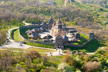

The historical and cultural museum "Zaporizka Sich" is placed on the northern rocky part of Khotritsa Island. The museum is a reconstruction of the stronghold of the Zaporizhzhian Cossacks, and contains features of the military camp life and their lifestyle.
Each of the smaller islands between the dam and the island Khortytsia has its own legend. On one of them, Durnya Scala ("Rock of the Fool"), Tzar Peter the Great flogged the Cossacks for their betrayal of the Russians during the Great Northern War between Russia and Sweden. Another small island, Stolb ("Pillar"), has a geological feature, which looks like a large bowl in granite slabs, the Cossack's Bowl. It is said that in summer days, water can be boiled in this "bowl", and the Cossacks used it for cooking galushki (boiled dough in a spicy broth).[75]
Transport links

Zaporizhzhia is an important transportation hub in Ukraine that includes roads, as well as rail, river and air links for passenger and freight transport. Zaporizhzhia International Airport, located to the east of the city on the left-bank of the Dnieper, serves domestic and international flights. Shyroke Airfield is to the west of the city on the right-bank of the Dnieper.
Zaporizhzhia is bypassed beyond its eastern outskirts by a major national highway M18, which connects Kharkiv with Simferopol. The H08, which starts just outside Kyiv and travels southeast along the Dnieper through Kremenchuk, Kamianske, Dnipro, passes through Zaporizhzhia on the way to Mariupol. The H15 from Donetsk and the H23 from Kropyvnytskyi via Kryvyi Rih, both end in Zaporizhzhia.
There are four road bridges and two rail bridges over the Dnieper, nearly all of which bridges cross Khortytsia Island. President Volodymyr Zelenskyy opened the first stage of the New Zaporizhzhia Dniper Bridge early in 2022.
The city has two rail stations, Zaporizhzhia-1 railway station and Zaporizhzhia-the-Second. The First is the central station, located in the southern part of the city and is a part of Simferopol-Kharkiv, the "north-south" transit route. The line of the Zaporizhzhia-the-Second station connects the Donbas coalfield with Kryvyi Rih. The city has an extensive tram network with 7 lines called the Zaporizhzhia Tram.
The city's two river ports are part of the national water transportation infrastructure that connects Kyiv to Kherson along the Dnieper. Freight ships and cutter boats travel between Zaporizhzhia and nearby villages. The island of Khortytsia splits the Dnieper into two; the main channel passes the island on its eastern side, with the Staryi Dnipro (Old Dnieper) flowing past the island on the western side.
Notable people


- Alyosha (born 1986), Ukrainian singer, stage name of Olena Oleksandrivna Kucher
- Vasiliy Bebko, (1932–2022), Russian diplomat
- Tamara Bulat (1933–2004), Ukrainian-American musicologist
- Victoria Bulitko (born 1983), a Ukrainian film, TV and theatre actress.
- Evgeniy Chernyak (born 1969), Ukrainian businessman
- Evgeniy Chuikov (1924–2000) Ukrainian landscape painter working in the Russian realist and French Impressionist traditions.
- Volodymyr Dakhno (1932–2006) Ukrainian animator and animation film director.
- Valentyna Danishevska (born 1957), Ukrainian lawyer and judge
- Gerhard Ens (1863–1952), farmer, immigration agent and politician in Saskatchewan
- Igor Fesunenko (1933–2016), Russian journalist and foreign affairs writer
- Arkady Gendler (1921–2017), Yiddish singer
- Sergey Glazyev (born 1961), Russian politician and economist
- Alina Gorlova (born 1992), a Ukrainian filmmaker, director, and screenwriter
- Konstantin Grigorishin (born 1965), a Russian-Ukrainian businessman and billionaire.
- Volodymyr Horbulin (born 1939), Ukrainian politician
- Valeriy Ivaschenko (born 1956), Ukrainian former Deputy Minister of Defence
- Boris Ivchenko, (1941–1990) Ukrainian actor and film director
- Igor P. Kaidashev (born 1969), Ukrainian immunologist and allergist
- Valeriy Kostyuk (born 1940), Russian scientist
- Maxim Ksenzov (born 1973), Russian statesman
- Valery Kulikov (born 1956), Ukrainian-born Russian politician
- Gosha Kutsenko (born 1967), Russian actor, producer, singer, poet and screenwriter
- Arsen Mirzoyan (born 1978), Ukrainian singer and songwriter
- Valentyn Nalyvaichenko (born 1966), Ukrainian diplomat and politician.
- Eva Neymann (born 1974), Ukrainian film director
- Maria Nikiforova (1885–1919), revolutionary insurgent and Anarchist partisan leader.
- Anna October (born 1991), Ukrainian fashion designer
- Aleksandr Panayotov (born 1984), Russian-Ukrainian singer and songwriter
- Mykhailo Papiyev (born 1960), Ukrainian engineer and politician
- Oleksandr Peklushenko, (1954–2015) Ukrainian politician
- Max Polyakov (born 1977), an international technology entrepreneur, economist and philanthropist
- Georgy Shchokin (born 1954), businessman, sociologist, psychologist and politician
- Boris Shtein, (1892–1961) Soviet diplomat
- Oleksandr Sin (born 1961), Ukrainian politician former mayor of Zaporizhzhia
- Serhiy Sobolyev (born 1961), Ukrainian politician
- Yanina Sokolova (born 1984) a journalist, TV presenter and actress.
- Naum Sorkin, (1899–1980) a Soviet military officer and diplomat.
- Oleksandr Starukh (born 1973), Ukrainian historian and politician
- Liudmyla Suprun (born 1965), a Ukrainian politician
- Yevhen Synelnykov (born 1981), a Ukrainian TV presenter, director and actor
- Estas Tonne (born 1975), a musician, plays guitar and flute
- Vladyslav Yama (born 1982), a Ukrainian dancer and educator
- Maksym Ostapenko (born 1971), Ukrainian scientist, archaeologist, cultural activist, and a soldier
- Vlad Savchenko (born 1991), film producer and public activist
Sport


- Polina Astakhova (1936–2005) an artistic gymnast; won ten medals at the 1956, 1960 and 1964 Summer Olympics.
- Anastasia Bliznyuk (born 1994), a Russian group rhythmic gymnast.
- Maksym Dolhov (born 1996), Ukrainian diver
- Yan Kovalevskyi (born 1993), Ukrainian footballer
- Tanja Logwin (born 1974), Ukrainian-born Austrian handball player
- Alina Maksymenko (born 1991), Ukrainian rhythmic gymnast
- Oleksii Pashkov (born 1981), silver medallist in the discus at the 2012 Summer Paralympics
- Volodymyr Polikarpenko (born 1972), Ukrainian former trialthon athlete
- Yakiv Punkin (1921–1994) wrestler, gold medallist at the 1952 Summer Olympics.
- Oksana Skaldina (born 1972) gymnast; bronze medallist at the 1992 Summer Olympics
- Ganna Sorokina (born 1976) diver; team bronze medallist at the 2000 Summer Olympics
- Olga Strazheva (born 1972) gymnast; team gold medallist at the 1988 Summer Olympics
- Vita Styopina (born 1976) high jumper; bronze medallist at the 2004 Summer Olympics
- Denys Sylantyev (born 1976) politician and swimmer; four time Olympian, silver medallist at the 2000 Summer Olympics and national flag bearer at the 2004 Summer Olympics.
- Razmik Tonoyan (born 1988), Ukrainian sambist, (a Soviet-origin Russian martial art)
- Roman Volod'kov (born 1973), Ukrainian former diver
- Sergiusz Wołczaniecki (born 1964) a Polish weightlifter; bronze medallist at the 1992 Summer Olympics
- Olena Zhupina (born 1973), Ukrainian diver
In popular culture
Zaporizhzhia is a setting in two Axis victory in World War II short novels by the American author Harry Turtledove, Ready for the Fatherland (1991) and The Phantom Tolbukhin (1998).
Twin towns – sister cities
Zaporizhzhia is twinned with:[76][77]
Lahti, Finland (1953)
Belfort, France (1967)
Birmingham, United Kingdom (1973)
Linz, Austria (1983)
Oberhausen, Germany (1986)
Yichang, China (1997)
Ashdod, Israel (2011)
Steinbach, Canada (2018)
In 1969, the city renamed one of its streets after the city of Wrocław. The Wrocław authorities reciprocated, and a part of the Sudecka – Grabiszyńska Street towards the Square of the Silesian Insurgents was renamed Zaporoska Street.[78]
See also
Notes
- ^ Also spelled as Zaporizhzhya or Zaporizhia.
- ^ Russian: Александровск, romanized: Aleksandrovsk; Ukrainian: Олександрівськ.
- ^ Since modern Zaporizhiazhia was greatly enlarged in the Soviet Union, many typography in the city had to be renamed. In the year of the fall of the Russian Empire (1917), the population of Alexandrovsk was about 60,000 people. In the year of Ukraine's declaration of independence (1991), the city's population reached almost 1 million people.
References
- ^ "Про затвердження транслітерації написання географічної назви міста Запоріжжя латиницею. Рішення виконавчого комітету №476". Zaporizhzhia city council. Executive committee. 28 August 2017. Archived from the original on 26 July 2020. Retrieved 20 January 2020.
- ^ (in Ukrainian) [1] Archived 6 May 2021 at the Wayback Machine
- ^ Чисельність наявного населення України на 1 січня 2022 [Number of Present Population of Ukraine, as of January 1, 2022] (PDF) (in Ukrainian and English). Kyiv: State Statistics Service of Ukraine. Archived (PDF) from the original on 4 July 2022.
- ^ a b Pospelov, pp. 25–26
- ^ Я. П. Новицкий. История города Александровска, (Екатеринославской губ.) в связи с историей возникновения крепостей Днепровской линии 1770–1806 г. Archived 3 March 2016 at the Wayback Machine – Екатеринослав: Типография Губернского Земства, 1905. – 176 с. (in Russian)
- ^ The bridges of Zaporizhzhia (Мосты Запорожья) Archived 8 March 2012 at the Wayback Machine, by L. Adelberg (Адельберг Л), pub RA Tandem st, Zaporizhzhia, 2005. (in Russian)
- ^ a b c d e f g Official Portal Zaporizhzhia city authorities, History (Офіційний портал, Запорізької міської влади, Історія міста) Archived 21 January 2012 at the Wayback Machine, accessed 11 April 2011. (in Ukrainian)
- ^ "Sovetskai︠a︡ arkhitektura". Искусство. 27 October 1969 – via Google Books.
- ^ Меерович М. Г. Соцгород – базовое понятие советской градостроительной теории первых пятилеток Archived 28 September 2011 at the Wayback Machine
- ^ "История Запорожья". photoalbum.zp.ua. Archived from the original on 2 May 2008. Retrieved 11 April 2011.
- ^ The Soviet economy and the Red Army, 1930–1945, by Walter Scott Dunn, Greenwood Publishing Group, 1995 ISBN 0-275-94893-5, page 13.
- ^ a b c The Great Patriotic War on the territory of Zaporizhzhia (Великая Отечественная война на территории Запорожья) Archived 20 December 2011 at the Wayback Machine (in Russian)
- ^ Germany and the Second World War, Volume IV The Attack on the Soviet Union, by Horst Boog, Jürgen Förster, Joachim Hoffmann, Ernst Klink, Rolf-Dieter Müller, Gerd R. Ueberschär, pub Clarendon Press, 1998, ISBN 0-19-822886-4, p. 909.
- ^ "The Eastern Front, Timeline 1941". Archived from the original on 19 July 2011. Retrieved 18 April 2011.
- ^ Radio Free Europe Radio Liberty Archived 22 September 2016 at the Wayback Machine, Ukrainian Activists Draw Attention To Little-Known WWII Tragedy , by Dmytro Moroz and Claire Bigg, 23 August 2013.
- ^ Germany and the Second World War, Volume IV The Attack on the Soviet Union, p. 607, says that Zaporizhzhia was captured on 1 October 1941.
- ^ Lost Victories, by Field Marshal Eric von Manstein, translated by Anthony G Powell, pdf version p267-270.
- ^ Lost Victories, by Field Marshal Eric von Manstein, pdf version p290-2.
- ^ Lost Victories, by Field Marshal Eric von Manstein, says that the Germans finished repairing the railway bridge only a few months before they lost the city in October 1943.
- ^ a b "The Eastern Front, Timeline 1943". Archived from the original on 19 July 2011. Retrieved 18 April 2011.
- ^ Moscow-Stalingrad-Berlin-Prague, Memories of Army Commander ("Москва-Сталінград-Берлін-Прага". Записки командарма) Archived 15 May 2013 at the Wayback Machine, by Dmitri Danilovich Lelyushenko (Лелюшенко Дмитро Данилович), pub Nauka, Moscow, 1987, chapter 4.
- ^ "Почему мосты строят по 14 лет – и что говорит Укравтодор". Archived from the original on 13 August 2018. Retrieved 4 July 2018.
- ^ Buckley, Neil (26 January 2014). "Ukraine protests spread to Yanukovich heartland". Financial Times. Archived from the original on 16 November 2018. Retrieved 27 October 2018.
- ^ "В Запорожье участники Майдана опечатали кабинеты руководства Запорожской ОГА : Новости УНИАН". Ukrainian Independent Information Agency. Archived from the original on 26 February 2014. Retrieved 24 February 2014.
- ^ Ukraine Tensions Escalate as Russia, U.S. Exchange Barbs Archived 15 September 2014 at the Wayback Machine
- ^ Poroshenko signed the laws about decommunization Archived 23 April 2016 at the Wayback Machine. Ukrainska Pravda. 15 May 2015
Poroshenko signs laws on denouncing Communist, Nazi regimes Archived 2 August 2018 at the Wayback Machine, Interfax-Ukraine. 15 May 20
Goodbye, Lenin: Ukraine moves to ban communist symbols Archived 7 March 2016 at the Wayback Machine, BBC News (14 April 2015) - ^ Vitaly Shevchenko (1 June 2016), In pictures: Ukraine removes communist-era symbols, BBC News, archived from the original on 27 December 2019, retrieved 30 September 2021
- ^ "Полный перечень переименованных в Запорожье улиц". Archived from the original on 5 December 2019. Retrieved 9 July 2018.
- ^ (in Ukrainian) In Zaporizhzhia began to "dekomunize" DniproGES Archived 30 September 2021 at the Wayback Machine, Radio Free Europe (4 April 2016)
- ^ Свобода, Радіо (27 February 2022). "Техніка росіян зайшла до Бердянська, в Запоріжжі зброю дають усім готовим захищати обласний центр". Радіо Свобода (in Ukrainian). Archived from the original on 27 February 2022. Retrieved 28 February 2022.
- ^ "Жителів Запоріжжя просять не покидати укриття: Обстрілюють аеродром – новини Запоріжжя". www.depo.ua (in Ukrainian). Archived from the original on 27 February 2022. Retrieved 28 February 2022.
- ^ "Video analysis reveals Russian attack on Ukrainian nuclear plant veered near disaster". NPR. 11 March 2022. Archived from the original on 1 April 2022. Retrieved 1 April 2022.
- ^ "Update 1-Ukraine nuclear power plant Zaporizhzhia on fire, town mayor says". Reuters. 4 March 2022. Retrieved 7 March 2022.
- ^ "Invaders fire missiles on Zaporizhzhia, Sumy region at night". 13 May 2022. Archived from the original on 16 May 2022. Retrieved 16 May 2022.
- ^ "Ukraine war: Survivors speak of horror as Zaporizhzhia convoy hit". BBC News. 30 September 2022. Archived from the original on 1 October 2022. Retrieved 30 September 2022.
- ^ "At least 17 are killed in Zaporizhzhia". The New York Times. 9 October 2022. Archived from the original on 9 October 2022. Retrieved 9 October 2022.
- ^ "Паспорт города Запорожье". photoalbum.zp.ua. Archived from the original on 2 October 2022. Retrieved 15 April 2011.
- ^ "The interactive map of island of Khortitsa (Russian)". Archived from the original on 2 July 2011. Retrieved 2 July 2011.
- ^ ПОГОДА в Запорожье (in Russian). Погода и климат. Archived from the original on 13 December 2019. Retrieved 8 November 2021.. Snow days have been taken to mean days on which it snowed, not days with snow cover on the ground.
- ^ "World Meteorological Organization Climate Normals for 1981–2010". World Meteorological Organization. Archived from the original on 17 July 2021. Retrieved 18 July 2021.
- ^ Головне управління статистики в Запорізькій області — Чисельність населення м. Запоріжжя Archived 13 February 2019 at the Wayback Machine на 1 листопада 2015 року]
- ^ "Cities & Towns of Ukraine".
- ^ "Zaporizhzhia · Population". population.city. Archived from the original on 4 July 2018. Retrieved 4 July 2018.
- ^ "Держстат України" (PDF). Archived from the original (PDF) on 25 February 2022. Retrieved 4 July 2018.
- ^ a b c d e Natalia Ostasheva Venger (2003). "The Mennonite Industrial Dynasties in Alexandrovsk". Journal of Mennonite Studies. Vol. V21. Dnipropetrovsk National University. pp. 89–110. Archived from the original on 19 August 2011. Retrieved 12 April 2011.
- ^ Collection of scientific works of graduate students (Збiрник наукових праць аспірантів), by T H Shevchenka, pub Vyd-vo Kyïvsʹkoho University, 1963, p87 Archived 3 September 2023 at the Wayback Machine gives the 1861 population as 3,729. (in Ukrainian)
- ^ Ripley, George; Dana, Charles A. (Charles Anderson) (27 October 1879). "The American cyclopaedia: a popular dictionary of general knowledge. Edited by George Ripley and Charles A. Dana". New York D. Appleton – via Internet Archive.
- ^ Brockhaus and Efron's Encyclopedia (Энциклопедический Словарь Ф.А.Брокгауза и И.А.Ефрона) Archived 21 December 2010 at the Wayback Machine, edited by Professor IE Andreevskago, and K. Arseniev, pub FA Brockhaus (Leipzig) and IA Efron (St Petersburg), 1890–1907, entry for Aleksandrovsk in Yekaterinoslavskaya province (Александровск, уездный город Екатеринославской губернии). (in Russian)
- ^ Universal Calendar for 1898 (Всеобщий календарь на 1898 год) Archived 8 January 2011 at the Wayback Machine, pub Hermann Hoppe (St Petersburg), 1898, p217 Archived 17 August 2011 at the Wayback Machine List of the populated areas of the Russian Empire, Abakan – Alekseevskoe (Роспись населённых местностей Российской империи, Абаканское – Алексеевское). (in Russian)
- ^ Large Encyclopedia (Большая Знциклопедія) Volume I, pub Prosveshechenie (St Petersburg), 1903, p323. pdf version (in Russian)
- ^ Russian Calendar for 1906 (Русский календарь на 1906 г.) Archived 8 January 2011 at the Wayback Machine, pub A. Suvorina (St Petersburg), 1906, p108 Archived 17 August 2011 at the Wayback Machine List of the populated areas of the Russian Empire, Abbas-Tuman – Belev (Список городов и других населённых пунктов Российской империи, Аббас-Туман – Белев). (in Russian)
- ^ a b Ukrainian SSR (Украинская ССР) Archived 3 September 2023 at the Wayback Machine, pub Economic Institute of the Ukrainian Academy of Sciences, 1958, p87.
- ^ Sergina V. "City Z:1921-199", film "Year 1926" Сергина В. Город Z: 1921–1991 (Невыдуманные истории): Исторически–познавательный ТВ проект для любой зрительской аудитории. – К., 2005. – 1 компакт – диск. Фильм "Год 1926"
- ^ Economic geography of the USSR Archived 13 January 2016 at the Wayback Machine by S S Balźak, V F Vasyutin, Ya G Feigin, pub Macmillan, 1956.
- ^ a b Half a century classified as 'Secret': All-Union census in 1937 (Полвека под грифом 'секретно': Всесоюзная перепись населения 1937 года) Archived 25 May 2013 at the Wayback Machine, by Valentina B Zhiromskaya, I Kiselev, Yu A Polyakov, pub Nauka, 1996. This gives the 1926 population as 55,295.(DJV-ZIP – requires DjVu viewer software Archived 9 April 2006 at the Wayback Machine) (in Russian)
- ^ a b The emergency evacuation of cities: a cross-national historical and geographical study Archived 26 April 2023 at the Wayback Machine, by Wilbur Zelinsky, Leszek A. Kosiński, pub Rowman & Littlefield, 1991, ISBN 0-8476-7673-0.
- ^ a b c The Great Soviet Encyclopedia (Большая Советская Энциклопедия), entry for Zaporizhzhia – Zaporizhzhia oblast centre (Запорожье – центр Запорізької обл.) Archived 24 March 2012 at the Wayback Machine, 3rd edition, pub 1969 to 1978. (in Russian)
- ^ Sergina V. "City Z:1921-199", film "Year 1942" (Сергина В. Город Z: 1921–1991 (Невыдуманные истории): Исторически–познавательный ТВ проект для любой зрительской аудитории. – К., 2005.- 1 компакт – диск. Фильм "Год 1942") said the population for 1942 was 103,400.
- ^ The Ukrainian quarterly, Volumes 26–27, pub Ukrainian Congress Committee of America, 1970, p223 Archived 3 September 2023 at the Wayback Machine.
- ^ The population of the USSR: According to the Proc. Census 1979 (Население СССР: По данным Всесоюзной переписи населения 1979 г.), pub Politizdat (Moscow), 1980 – table: USSR, the Soviet population in 1979, cities with a population of 100 thousand and more people (СССР, население СССР на 1979 год, Население союзных и автономных республик) Archived 21 July 2011 at the Wayback Machine. (in Russian)
- ^ www.larousse.fr/encyclopedie L’Encyclopédie en ligne entry for Zaporojie. (in French)
- ^ Rand McNally atlas of world geography, pub Rand McNally Company, 1996, p38.
- ^ The size and composition of the population of Zaporizhzhia region up to the Ukrainian population census 2001 (Численность и состав населения Запорожской области по итогам Всеукраинской переписи населения 2001 года) Archived 23 July 2011 at the Wayback Machine. (in Russian)
- ^ Population on 1 August 2010 (Чисельність населення на 1 серпня 2010 року), press release No 1377 issued by the State Department of Statistics in the Zaporizhzhia oblast (Держкомстат. Головне управління статистики у Запорізькій області), 16 September 2010[dead link]. (in Ukrainian)
- ^ Population on 1 March 2011 (Чисельність населення на 1 березня 2011 року), press release No 1163 issued by the State Department of Statistics in the Zaporizhzhia oblast (Держкомстат. Головне управління статистики у Запорізькій області), 18 April 2011 Archived 8 July 2012 at the Wayback Machine. (in Ukrainian)
- ^ [2][permanent dead link]
- ^ "ЧИСЕЛЬНІСТЬ НАЯВНОГО НАСЕЛЕННЯ УКРАЇНИ" (PDF) (in Ukrainian). 1 January 2017. Archived from the original (PDF) on 25 February 2022. Retrieved 4 July 2018.
- ^ Лозовой Н. (17 January 2011). "Этнические войны: украинская версия". Истеблишмент. Archived from the original on 15 August 2011.
- ^ "Demoskop Weekly: Prilozhenie. Spravochnik statisticheskikh pokazateleĭ" Демоскоп Weekly – Приложение. Справочник статистических показателей. [Demoscope Weekly: appendix. Digest of statistical indicators.]. www.demoscope.ru. Archived from the original on 19 September 2020. Retrieved 15 January 2021.
- ^ Vsesoi͡uznai͡a perepisʹ naselenii͡a 1926 goda Всесоюзная перепись населения 1926 года [All-union census of population 1926]. Moscow: Издание ЦСУ Союза ССР. 1928–1929.
- ^ Romant͡sov, V. O. "Населення України і його рідна мова за часів радянської влади та незалежності" Naselenni͡a Ukraïny i ĭoho ridna mova za chasiv radi͡ansʹkoï vlady ta nezalez͡hnosti [The population of Ukraine and its native language in the periods of the Soviet régime and independence]. Archived from the original on 6 March 2016. Retrieved 15 January 2021.
- ^ "Vseukraïnsʹkyĭ perepys naselenni͡a 2001 roku: Rozpodil naselenni͡a za ridnoi͡u movoi͡u, Zaporizʹka oblastʹ" Всеукраїнський перепис населення 2001 року. Розподіл населення за рідною мовою, Запорізька область [All-Ukrainian census of population 2001: Distribution of population by native language, Zaporizka oblast.]. Archived from the original on 6 March 2016. Retrieved 1 June 2021.
- ^ "Религиозная карта области". Остров Свободы (in Russian). Archived from the original on 17 June 2008. Retrieved 17 April 2011.
- ^ Helena Krasowska,The Polish Minority in South-Eastern Ukraine, pub Institute of Slavic Studies, Polish Academy of Sciences, 2017, ISBN 978-83-64031-65-6, p. 50-52.
- ^ Galina and Maxim Ostapenko, History of our Khortytsia (Галина и Максим Остапенко История нашей Хортицы) Archived 31 August 2011 at the Wayback Machine
- ^ "Города-побратимы". zp.gov.ua (in Russian). Zaporizhzhia. Archived from the original on 27 May 2019. Retrieved 10 December 2022.
- ^ "Steinbach Becomes Twin City With Zaporizhzhia". Archived from the original on 12 January 2020. Retrieved 11 January 2020.
- ^ "Wrocław, ul. Zaporoska – Dolny.Slask.org.pl". Archived from the original on 29 September 2011. Retrieved 29 July 2011.
Sources
- Е. М. Поспелов (Ye. M. Pospelov). "Имена городов: вчера и сегодня (1917–1992). Топонимический словарь." (City Names: Yesterday and Today (1917–1992). Toponymic Dictionary." Москва, "Русские словари", 1993.
External links
- Official portal of Zaporizhzhia City (in Ukrainian)
- One of the portals of Zaporizhzhia City (in Russian)
- Another one of the portals of Zaporizhzhia City (in Russian)
- Zaporizhzhia seven ways to adventure
- One of the few external reports on the city in English is the BBC report "Ukraine: Why the Orange Revolution ran out of steam", Daniel Sandford, Moscow correspondent, BBC News 10 March 2011.
- Zaporizhzhia
- Alexandrovsky Uyezd (Yekaterinoslav Governorate)
- Populated places established in 1770
- Cities of regional significance in Ukraine
- 1770 establishments in Ukraine
- Populated places established in the Russian Empire
- 1770 establishments in the Russian Empire
- Populated places on the Dnieper in Ukraine
- Oblast centers in Ukraine
- Cities in Zaporizhzhia Oblast