Lumber River
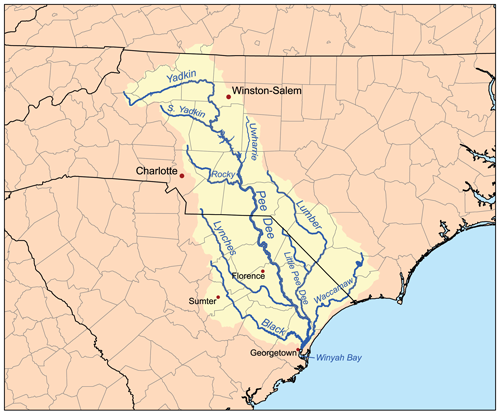
The Lumber River, also known as the Lumbee River, is located in south-central North Carolina in the flat Coastal Plain. The river's headwaters are known as Drowning Creek, and the waterway known as the Lumber River extends downstream from the Scotland County-Hoke County border to the North Carolina-South Carolina border. Soon after crossing into South Carolina, the Lumber River flows into the Little Pee Dee River, which then flows into the Pee Dee River, or Great Pee Dee River, from there into Winyah Bay, and finally into the Atlantic Ocean.
History
According to poet John Charles McNeill (1874-1907), the Indian name of Lumbee was originally used for the river, from an Indian word that means "black water."
Pre-European contact period
A number of archaeological sites have been excavated on high ground along the river. While most of these areas have been disturbed by the agricultural and forestry practices of the post-Columbian era, isolated artifacts and fossils have been uncovered, including a dugout canoe estimated to be over 1,025 years old. This ancient canoe, on display at the University of North Carolina at Pembroke corroborates the claims of the Lumbee Indians that their pre-Columbian ancestors navigated the river for trading, fishing, hunting, and other cultural activities. Much of the archaeological work in the Lumber River region has been done in Robeson County. Four hundred and twenty-nine archaeological sites have been recorded in this area alone. Each site was classified under one of four categories: Paleo-Indian, Archaic Woodland, Mississippian and Historic. There are 47 sites with potential archaeological importance, 20 of which have been nominated to the National Register of Historic Places.
There is no other Historical reference to the word Lumbee except in a poem in the late 1800,s
Eighteenth century
By the 18th century, the river and its associated swamps had become a melting pot for several Indian tribes. The majority of Native peoples had been forced to become refugees who had fled to the backwoods and swamplands that surround the Lumber River. Remnant Siouan, Algonkian, and Iroquoian peoples sought to escape the attacks of other tribes as well as the violent incursions of Europeans.
Ignoring, or perhaps being unaware of what Native peoples called the river, early English surveyors renamed it "Drowning Creek." In 1749, British colonial records identified the river as a branch of the Little Pee Dee River. The North Carolina state legislature changed the name to the Lumber River in 1809, most likely because of the river's heavy use by the lumber industry.
Nineteenth century
In the late 18th and the 19th centuries, the lumbering and naval stores industries were critical to the region. The newly-named Lumber River became a vital route for transporting one-hundred-foot logs downriver to Georgetown, South Carolina. Lumberton, North Carolina served as an important turpentine and timber town. The region's economy was dependent on the success or failure of the lumber and naval stores industries and bridge abutments, tram bridges, and dock pilings are reminders of the critical importance of lumbering and naval stores industries to the area as a whole.
After the American Civil War and Reconstruction, conservative Democrat Hamilton McMillan, who represented Robeson County in the North Carolina Legislature, speculated that the descendants of Sir Walter Raleigh's "Lost Colony" may have been among these Native American refugees who had been forced to flee into to protective swamps of the area. The earliest European travelers to Robeson County found a community of several thousand Indians who were agrarians and spoke a peculiar form of English. Having survived the encroachment of their lands, the region's Native people established settlements on the banks of the river where their descendants, known as the Lumbee, continue to live. The tribe officially changed its name to Lumbee in 1953.

Recreation
Currently, the Lumber River is a highly prized recreation site in North Carolina. Active outdoor recreation and festivals are among the most popular activities, as well as canoeing, boating, fishing, hunting, picnicking, camping, nature study, swimming, biking, jogging, crafts, and fossil and artifact hunting.
Lumber River State Park
There are 24 boat launches along the Lumber River that serve as access points to Lumber River State Park. The entire length of the river is open to fishing. The common game fish are black crappie, largemouth bass, catfish and redbreast sunfish. All anglers must have a valid fishing license and follow the regulations of the North Carolina Wildlife Resources Commission. Nine primitive camping sites are located at the Princess Ann section of the park, between Orrum and Fair Bluff. These campsites are meant to be used by no more than 6 people at a time. Each camp site features, a picnic table and grill, lantern holder, trash can, and fire ring. There are several hiking trails and picnic areas at Princess Ann as well as the many municipal and county parks that are located on the Lumber River.[1]
References
- ^ "Lumber River State Park". North Carolina Department of Environment and Natural Resources. Retrieved 2007-04-11.