
אין גרסה ברזולוציה גבוהה יותר.
Izmit_eart3.jpg (640 × 480 פיקסלים, גודל הקובץ: 54 ק"ב, סוג MIME: image/jpeg)
Source: https://earthquake.usgs.gov/research/geology/turkey/8-26-99.php
| Public domainPublic domainfalsefalse
|
נא להוסיף משפט שמסביר מה הקובץ מייצג
Collapsed constructions at Gölcük Earthquake, 1999
Gölcük deprem enkazı
Durch das Erdbeben von Gölcük 1999 zerstörte Gebäuden
\u05e8\u05e2\u05d9\u05d3\u05ea \u05d0\u05d3\u05de\u05d4<\/a>"}},"text\/plain":{"he":{"P180":"\u05e8\u05e2\u05d9\u05d3\u05ea \u05d0\u05d3\u05de\u05d4"}}}}" class="wbmi-entityview-statementsGroup wbmi-entityview-statementsGroup-P180 oo-ui-layout oo-ui-panelLayout oo-ui-panelLayout-framed">
\u05e8\u05e2\u05d9\u05d3\u05ea \u05d4\u05d0\u05d3\u05de\u05d4 \u05d1\u05d0\u05d9\u05d6\u05de\u05d9\u05d8<\/a>"}},"text\/plain":{"he":{"P793":"\u05e8\u05e2\u05d9\u05d3\u05ea \u05d4\u05d0\u05d3\u05de\u05d4 \u05d1\u05d0\u05d9\u05d6\u05de\u05d9\u05d8"}}}}" class="wbmi-entityview-statementsGroup wbmi-entityview-statementsGroup-P793 oo-ui-layout oo-ui-panelLayout oo-ui-panelLayout-framed">
\u05e8\u05e9\u05d5\u05ea \u05d4\u05e6\u05d9\u05d1\u05d5\u05e8<\/a>"}},"text\/plain":{"he":{"P6216":"\u05e8\u05e9\u05d5\u05ea \u05d4\u05e6\u05d9\u05d1\u05d5\u05e8"}}},"{\"value\":{\"entity-type\":\"property\",\"numeric-id\":1001,\"id\":\"P1001\"},\"type\":\"wikibase-entityid\"}":{"text\/html":{"he":{"":"
\u05e9\u05d8\u05d7 \u05e9\u05d9\u05e4\u05d5\u05d8<\/a>"}},"text\/plain":{"he":{"":"\u05e9\u05d8\u05d7 \u05e9\u05d9\u05e4\u05d5\u05d8"}}},"{\"value\":{\"entity-type\":\"item\",\"numeric-id\":30,\"id\":\"Q30\"},\"type\":\"wikibase-entityid\"}":{"text\/html":{"he":{"P1001":"\u05d0\u05e8\u05e6\u05d5\u05ea \u05d4\u05d1\u05e8\u05d9\u05ea<\/a>"}},"text\/plain":{"he":{"P1001":"\u05d0\u05e8\u05e6\u05d5\u05ea \u05d4\u05d1\u05e8\u05d9\u05ea"}}},"{\"value\":{\"entity-type\":\"property\",\"numeric-id\":459,\"id\":\"P459\"},\"type\":\"wikibase-entityid\"}":{"text\/html":{"he":{"":"\u05d4\u05d5\u05d2\u05d3\u05e8 \u05dc\u05e4\u05d9<\/a>"}},"text\/plain":{"he":{"":"\u05d4\u05d5\u05d2\u05d3\u05e8 \u05dc\u05e4\u05d9"}}},"{\"value\":{\"entity-type\":\"item\",\"numeric-id\":60671452,\"id\":\"Q60671452\"},\"type\":\"wikibase-entityid\"}":{"text\/html":{"he":{"P459":"work of the federal government of the United States<\/a>\u00a0\u05d0\u05e0\u05d2\u05dc\u05d9\u05ea<\/sup>"}},"text\/plain":{"he":{"P459":"work of the federal government of the United States"}}}}" class="wbmi-entityview-statementsGroup wbmi-entityview-statementsGroup-P6216 oo-ui-layout oo-ui-panelLayout oo-ui-panelLayout-framed">היסטוריית הקובץ
ניתן ללחוץ על תאריך/שעה כדי לראות את הקובץ כפי שנראה באותו זמן.
| תאריך/שעה | תמונה ממוזערת | ממדים | משתמש | הערה |
|---|
| נוכחית | 18:35, 25 במרץ 2007 | 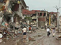 | 480 × 640 (54 ק"ב) | Orlovic | Source: http://earthquake.usgs.gov/research/geology/turkey/usgsteam2/pages/f4-28.html {{USGS}} |
שימוש בקובץ
שימוש גלובלי בקובץ
אתרי הוויקי השונים הבאים משתמשים בקובץ זה:
- שימוש באתר ar.wikipedia.org
- שימוש באתר da.wikipedia.org
- שימוש באתר de.wikipedia.org
- שימוש באתר el.wikipedia.org
- שימוש באתר en.wikipedia.org
- שימוש באתר fr.wikipedia.org
- שימוש באתר fy.wikipedia.org
- שימוש באתר ga.wikipedia.org
- שימוש באתר gv.wikipedia.org
- שימוש באתר hu.wikipedia.org
- שימוש באתר id.wikipedia.org
- שימוש באתר ms.wikipedia.org
- שימוש באתר nl.wikipedia.org
- שימוש באתר oc.wikipedia.org
- שימוש באתר pt.wikipedia.org
- שימוש באתר ro.wikipedia.org
- שימוש באתר tr.wikipedia.org
- שימוש באתר tr.wikisource.org
- שימוש באתר vls.wikipedia.org
- שימוש באתר zh.wikipedia.org
קובץ זה מכיל מידע נוסף, שכנראה הגיע ממצלמה דיגיטלית או מסורק שבהם הקובץ נוצר או עבר דיגיטציה.
אם הקובץ שונה ממצבו הראשוני, כמה מהנתונים להלן עלולים שלא לשקף באופן מלא את הקובץ הנוכחי.
