ไฟล์:Locator map RB Mittelfranken in Bavaria.svg

ขนาดของตัวอย่าง PNG นี้ของไฟล์ SVG นี้: 608 × 600 พิกเซล ความละเอียดอื่น: 243 × 240 พิกเซล | 487 × 480 พิกเซล | 779 × 768 พิกเซล | 1,038 × 1,024 พิกเซล | 2,077 × 2,048 พิกเซล | 867 × 855 พิกเซล
ดูภาพที่มีความละเอียดสูงกว่า ((ไฟล์ SVG, 867 × 855 พิกเซล, ขนาดไฟล์: 1,010 กิโลไบต์))
| รูปภาพหรือไฟล์เสียงนี้ ต้นฉบับอยู่ที่ คอมมอนส์ รายละเอียดด้านล่าง เป็นข้อความที่แสดงผลจาก ไฟล์ต้นฉบับในคอมมอนส์
|
ความย่อ


การอนุญาตใช้สิทธิ
ข้าพเจ้า ในฐานะผู้ถือลิขสิทธิ์ของภาพหรือสื่อนี้ อนุญาตให้ใช้ภาพหรือสื่อนี้ภายใต้เงื่อนไขต่อไปนี้

|
อนุญาตให้คัดลอก แจกจ่ายและ/หรือดัดแปรเอกสารนี้ภายใต้เงื่อนไขของสัญญาอนุญาตเอกสารเสรีของกนู รุ่น 1.2 หรือรุ่นใด ๆ นับจากนี้ที่ออกโดยมูลนิธิซอฟต์แวร์เสรี โดยไม่มีส่วนใดห้ามแก้ไข ไม่มีข้อความปกหน้าและปกหลัง สำเนาของสัญญาอนุญาตรวมอยู่ในส่วนชื่อ สัญญาอนุญาตเอกสารเสรีของกนู |
ไฟล์นี้อยู่ภายใต้สัญญาอนุญาตครีเอทีฟคอมมอนส์ รุ่นแสดงที่มา-อนุญาตแบบเดียวกัน 3.0 ต้นฉบับ, 2.5 ทั่วไป, 2.0 ทั่วไป และ 1.0 ทั่วไป
- คุณสามารถ:
- ที่จะแบ่งปัน – ที่จะทำสำเนา แจกจ่าย และส่งงานดังกล่าวต่อไป
- ที่จะเรียบเรียงใหม่ – ที่จะดัดแปลงงานดังกล่าว
- ภายใต้เงื่อนไขต่อไปนี้:
- แสดงที่มา – คุณต้องให้เกียรติเจ้าของงานอย่างเหมาะสม โดยเพิ่มลิงก์ไปยังสัญญาอนุญาต และระบุหากมีการเปลี่ยนแปลง คุณอาจทำเช่นนี้ได้ในรูปแบบใดก็ได้ตามควร แต่ต้องไม่ใช่ในลักษณะที่แนะว่าผู้ให้อนุญาตสนับสนุนคุณหรือการใช้งานของคุณ
- อนุญาตแบบเดียวกัน – หากคุณดัดแปลง เปลี่ยนรูป หรือต่อเติมงานนี้ คุณต้องใช้สัญญาอนุญาตแบบเดียวกันหรือแบบที่เหมือนกับสัญญาอนุญาตที่ใช้กับงานนี้เท่านั้น
คุณสามารถเลือกสัญญาอนุญาตดังกล่าวตามต้องการ
ประวัติไฟล์
คลิกวันที่/เวลาเพื่อดูไฟล์ที่ปรากฏในขณะนั้น
| วันที่/เวลา | รูปย่อ | ขนาด | ผู้ใช้ | ความเห็น | |
|---|---|---|---|---|---|
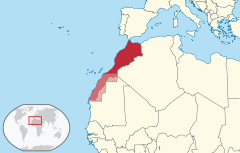
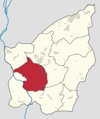
| ปัจจุบัน | 01:11, 26 มีนาคม 2552 | 867 × 855 (1,010 กิโลไบต์) | TUBS | =={{int:filedesc}}== {{Information |Description= {{de|Lage von Regierungsbezirk Mittelfranken in Bayern, Deutschland}} {{en|Locator map of Regierungsbezirk Mittelfranken in Bavaria, [[:en:Germany|Germany] |
หน้าที่มีภาพนี้
หน้าต่อไปนี้ โยงมาที่ภาพนี้:
การใช้ไฟล์ข้ามโครงการ
วิกิอื่นต่อไปนี้ใช้ไฟล์นี้:
- การใช้บน an.wikipedia.org
- การใช้บน ar.wikipedia.org
- การใช้บน az.wikipedia.org
- การใช้บน bg.wikipedia.org
- การใช้บน ca.wikipedia.org
- การใช้บน cs.wikipedia.org
- การใช้บน de.wikipedia.org
- การใช้บน en.wikipedia.org
- การใช้บน eo.wikipedia.org
- การใช้บน es.wikipedia.org
- การใช้บน et.wikipedia.org
- การใช้บน eu.wikipedia.org
- การใช้บน fa.wikipedia.org
- การใช้บน frr.wikipedia.org
- การใช้บน fr.wikipedia.org
- การใช้บน gl.wikipedia.org
- การใช้บน hu.wikipedia.org
- การใช้บน hy.wikipedia.org
- การใช้บน lmo.wikipedia.org
- การใช้บน nds.wikipedia.org
- การใช้บน nl.wikipedia.org
- การใช้บน os.wikipedia.org
- การใช้บน pl.wikipedia.org
- การใช้บน pl.wikivoyage.org
- การใช้บน pl.wiktionary.org
- การใช้บน ro.wikipedia.org
- การใช้บน ru.wikipedia.org
- การใช้บน simple.wikipedia.org
- การใช้บน sv.wikipedia.org
- การใช้บน tr.wikipedia.org
- การใช้บน ur.wikipedia.org
- การใช้บน vi.wikipedia.org
- การใช้บน www.wikidata.org