Fayl:Kirgisen-Reich (840-924).PNG
Asl fayl (1 253 × 781 piksel, fayl hajmi: 1,42 MB, MIME tipi: image/png)
Qisqa izoh
| Taʼrif |
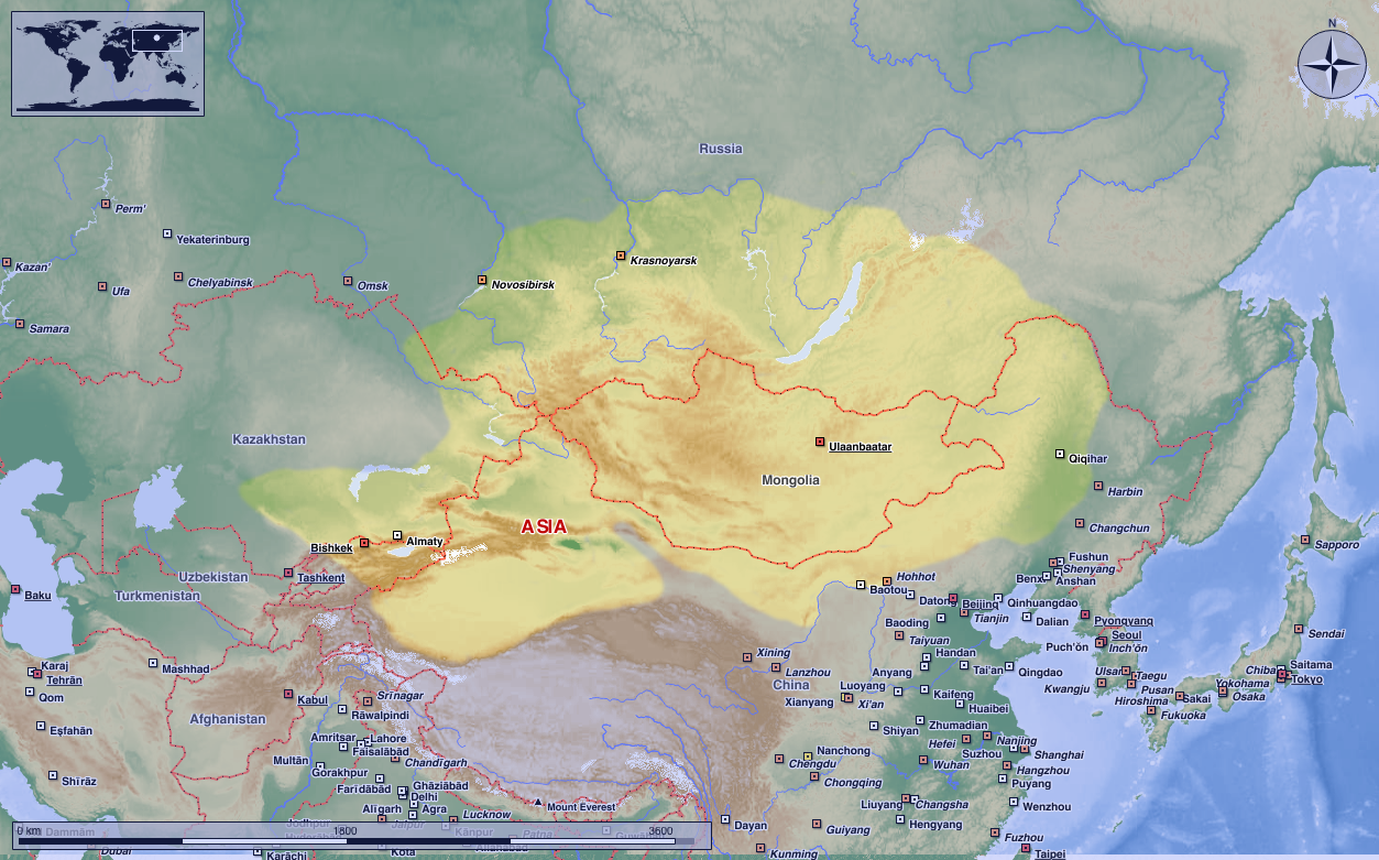
Deutsch: Das Kirgisen-Reich in seiner größten Ausdehung.
(Original text: Darstellungskarte zeigt das Kirgisen-Reich, das 840 das stammverwandte Reich der Uiguren zerschlug und dessen Erbe antrat. Als Vorlage dieser Landkarte diente 2004 eine Abbildung historischer türkischsprachiger Imperien, die vonseiten einer türkischen Regierungsseite veröffentlicht wurde. Heute ist die Quell-Seite nicht mehr aufrufbar, sodass deren Kartengrundlage – sofern eine angegeben wurde – nicht mehr nachprüfbar ist! 中文:叶尼塞吉尔吉斯的活动范围,吉尔吉斯人并没有在蒙古高原建立稳固的政权。
English: The map shows the Kyrgyz empire, which destroyed the related empire of the Uyghurs in 840 and inherited it. The cartography was derived from a 2004 depiction of past Turkic-speaking empires that was made available on a website of the Turkish government. Currently, the source page is inaccessible, thereby rendering the verification of the map's basis, if indeed one was provided, impossible.
Probably, the Turkish gouvernment intentionally inflated the geographical scope of the Kirghiz empire to establish a sense of continuity among the Göktürks, the Uighurs, and the surrounding empires. It is theoretically possible that the nomadic Kirghiz people during that period established small village communities (Aul's) in fewer households in the northern region of present-day Xinjiang, western Mongolia (Hirgiz nuur "Kirghiz Lake"?), eastern Mongolia ("Kerulen Kirghiz"?), and Manchuria ("Fuyu Kirghiz"?). However, most of the Kirghiz people of that era consistently returned to their original ancestral lands on the Yenisei subsequent to raids in these regions. The establishment of towns and the evolution of administrative systems throughout the Kirghiz Empire remain unknown. Moreover, they have also been discovered in smaller clusters in the Altai and Sayan Mountains, indicating that these regions were under the direct control of the Kirghiz Empire. It is widely “accepted” that the Kyrgyz habitation area during that period was located in regions spanning around 198,000 km², namely between the Lena, Irtish, Lake Baikal, and the Tian Shan.
|
| Sanasi | 17 avgust 2004 (original upload date) |
| Manba | Transferred from de.wikipedia to Commons. |
| Muallif | Postmann Michael |
| Ruxsat (Bu faylning takror foydalanilishi) |
Public Domain |
| Other versions | File:Map of the Kyrgyz empire (840–924).png |
Litsenziyalash
| I, the copyright holder of this work, release this work into the public domain. This applies worldwide. In some countries this may not be legally possible; if so: I grant anyone the right to use this work for any purpose, without any conditions, unless such conditions are required by law. |
Original upload log
- 2004-08-17 00:57 Postmann Michael 752×591× (37783 bytes) Das Kirgisen-Reich in seiner größten Ausdehung.
Fayl tarixi
Faylning biror paytdagi holatini koʻrish uchun tegishli sana/vaqtga bosingiz.
| Sana/Vaqt | Miniatura | Oʻlchamlari | Foydalanuvchi | Izoh | |
|---|---|---|---|---|---|
| joriy | 00:44, 21-avgust 2023 | 1 253 × 781 (1,42 MB) | HapHaxion | Reverted to version as of 17:01, 15 April 2021 (UTC) | |
| 23:18, 8-may 2023 | 1 048 × 614 (757 KB) | JJUPLOADS22 | Reverted to version as of 20:27, 14 April 2021 (UTC) | ||
| 17:01, 15-aprel 2021 | 1 253 × 781 (1,42 MB) | MicBy67 | Reverted to version as of 14:30, 22 August 2020 (UTC). No improvement. | ||
| 20:27, 14-aprel 2021 | 1 048 × 614 (757 KB) | Бмхүн | Adjust resolution | ||
| 14:30, 22-avgust 2020 | 1 253 × 781 (1,42 MB) | MicBy67 | Reverted to version as of 14:05, 22 August 2020 (UTC) | ||
| 14:30, 22-avgust 2020 | 752 × 591 (37 KB) | MicBy67 | Reverted to version as of 17:09, 10 May 2009 (UTC) | ||
| 14:05, 22-avgust 2020 | 1 253 × 781 (1,42 MB) | MicBy67 | Revision of the existing file. Topography, cities, etc. according to Marble (public domain) | ||
| 17:09, 10-may 2009 | 752 × 591 (37 KB) | Nachcommonsverschieber | {{Information |Description={{de|Das Kirgisen-Reich in seiner größten Ausdehung. ----<br/> (Original text : ''Darstellungskarte zeigt das Kirgisen-Reich, das 840 das stammverwandte Reich der Uiguren zerschlug und dessen Erbe antrat.'') * erstellt am: 17. |
Fayllarga ishoratlar
Bu faylga quyidagi sahifa bogʻlangan:
Faylning global foydalanilishi
Ushbu fayl quyidagi vikilarda ishlatilyapti:
- ar.wikipedia.org loyihasida foydalanilishi
- az.wikipedia.org loyihasida foydalanilishi
- bn.wikipedia.org loyihasida foydalanilishi
- en.wikipedia.org loyihasida foydalanilishi
- fr.wikipedia.org loyihasida foydalanilishi
- id.wikibooks.org loyihasida foydalanilishi
- kk.wikipedia.org loyihasida foydalanilishi
- pt.wikipedia.org loyihasida foydalanilishi
- ru.wikipedia.org loyihasida foydalanilishi
- ta.wikipedia.org loyihasida foydalanilishi
- tr.wikipedia.org loyihasida foydalanilishi
- www.wikidata.org loyihasida foydalanilishi