File:Verbreitungsgebiet der heutigen niederdeutschen Mundarten.svg

Dimensioni di questa anteprima PNG per questo file SVG: 555 × 599 pixel. Altre risołusion: 222 × 240 pixel | 444 × 480 pixel | 711 × 768 pixel | 948 × 1 024 pixel | 1 897 × 2 048 pixel | 789 × 852 pixel.
File orixenałe (file en formato SVG, dimension nominałi 789 × 852 pixel, dimension del file: 289 KB)
Somario
| Descrision |
Deutsch: Darstellungskarte der niederdeutschen Mundarten seit 1945
English: Distribution map of the Low Saxon and Low Franconian languages since 1945. Note however that it's bad: "Niedersächsische Mundarten [Low Saxon dialects]: ... 4 = Ostfriesisch [East Frisian] 5 Niedersächsische Dialekte in den Niederlanden [Low Saxon dialects in the Netherlands]" – Parts of what's labelled East Frisian are in the North-East of the Netherlands. Und auch: “niederrheinisch” statt “niederreihnisch” (n°15). |
| Data | (UTC) |
| Provenjiensa | |
| Autore |
|
| Altre version |
Englisch / English: 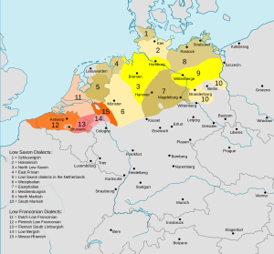 |


Licensa de doparasion:
Mi, che detegno el dirito d'autor su sta opera, la pùblico qua soto la seguente licensa:
Sto file el xe soto ła liçensa Creative Commons Atribusion-Spartisi in te ła stesa manjiera 3.0 Xenèrego.
- Te si libaro:
- de spartire in jiro – de copiar, distribuir e trasmétar sta opera
- de modifegar – de adatar sta opera
- Soto le seguenti condision:
- atribussion – Te ghe da atribuir ƚa paternità de ƚ'opera ne i modi indicà de l'autor o da chi te gà dà l'opera en lisensa, e en modo tale da no sugerir che lori i sia d'acordo con ti o col modo che te dòpari l'opera.
- spartisi in te ła stesa manjiera – Se te mis-ci, trasformi o dexviłupi sto laoro, te ghè da spartire łe to contribusion segondo ła stesa liçensa o na conpatibiłe a l'orixenałe.
Registro original del caricamento
This image is a derivative work of the following images:
- File:Verbreitungsgebiet_der_heutigen_niederdeutschen_Mundarten.PNG licensed with PD-user-de, PD-user-w
- 2008-08-08T10:33:32Z Gruna 1 652x652 (37059 Bytes) See previous version
- 2006-04-14T17:48:45Z Vonvon 652x652 (36806 Bytes) * created on de.wikipedia.org by [[:de:Benutzer:Postmann Michael]] on 31 December 2004 * Beschreibung:Darstellungskarte der niederdeutschen Mundarten seit 1945 (''Location Map of the Low Germanic languages'') * original licen
- File:Europe.svg licensed with PD-USGov-CIA-WF
Uploaded with derivativeFX
Istoria del file
Schicia so on grupo data/or pa vedare el file come che el se presentava in tel momento indegà.
| Data/Ora | Miniadura | Dimension | Utente | Comento | |
|---|---|---|---|---|---|
| In ultima | 20:29, 7 ago 2022 | 789 × 852 (289 KB) | Mc zelani | Reverted to version as of 14:40, 7 February 2011 (UTC) | |
| 20:50, 12 dis 2017 | 700 × 650 (247 KB) | Alphathon | Korrekturen | ||
| 19:04, 11 dis 2017 | 700 × 650 (280 KB) | Alphathon | Reverted to version as of 22:05, 27 October 2015 (UTC) Uploaded wrong language version | ||
| 19:02, 11 dis 2017 | 700 × 650 (245 KB) | Alphathon | Correction (Holland → the Netherlands) | ||
| 00:05, 28 oto 2015 | 700 × 650 (280 KB) | Alphathon | Cropped and corrected an error (Vistula Lagoon) | ||
| 17:35, 27 avr 2015 | 789 × 852 (289 KB) | Groupsixty | verschiedene Schreibfehler korrigiert | ||
| 16:40, 7 feb 2011 | 789 × 852 (289 KB) | Alphathon | {{Information |Description={{de|Darstellungskarte der niederdeutschen Mundarten seit 1945}} {{en|Distribution map of the Low Saxon and Low Franconian languages since 1945}} |Source=*[[:File:Verbreitungsgebiet_der_heutigen_niederdeutschen_Mundarten.PNG|Ver |
Doparasion del file
Ła pajina che vien ła dopara sto file:
Doparasion globałe del file
St'altre wiki cua le dopara sto file:
- Uxo de af.wikipedia.org inte le pàjine
- Uxo de als.wikipedia.org inte le pàjine
- Uxo de an.wikipedia.org inte le pàjine
- Uxo de az.wikipedia.org inte le pàjine
- Uxo de ba.wikipedia.org inte le pàjine
- Uxo de be.wikipedia.org inte le pàjine
- Uxo de bg.wikipedia.org inte le pàjine
- Uxo de ca.wikipedia.org inte le pàjine
- Uxo de ca.wiktionary.org inte le pàjine
- Uxo de cv.wikipedia.org inte le pàjine
- Uxo de de.wikipedia.org inte le pàjine
- Uxo de de.wiktionary.org inte le pàjine
- Uxo de es.wikipedia.org inte le pàjine
- Uxo de fr.wikipedia.org inte le pàjine
- Uxo de ga.wikipedia.org inte le pàjine
- Uxo de hak.wikipedia.org inte le pàjine
- Uxo de hr.wikipedia.org inte le pàjine
- Uxo de it.wikipedia.org inte le pàjine
- Uxo de ja.wikipedia.org inte le pàjine
- Uxo de li.wikipedia.org inte le pàjine
- Uxo de lmo.wikipedia.org inte le pàjine
- Uxo de nds.wikipedia.org inte le pàjine
- Uxo de nl.wikipedia.org inte le pàjine
- Uxo de no.wikipedia.org inte le pàjine
- Uxo de oc.wikipedia.org inte le pàjine
- Uxo de ro.wikipedia.org inte le pàjine
- Uxo de ru.wikipedia.org inte le pàjine
- Uxo de ru.wikiversity.org inte le pàjine
- Uxo de sc.wikipedia.org inte le pàjine
- Uxo de sh.wikipedia.org inte le pàjine
Varda ła doparasion globałe de sto file.