原始文件 (2,956 × 1,600像素,文件大小:578 KB,MIME类型:image/jpeg)
摘要
\u99ac\u7c60\u5bbf<\/a>"}},"text\/plain":{"zh":{"P180":"\u99ac\u7c60\u5bbf"}}}}" class="wbmi-entityview-statementsGroup wbmi-entityview-statementsGroup-P180 oo-ui-layout oo-ui-panelLayout oo-ui-panelLayout-framed">
\u5ba2\u4f53\u89d2\u8272<\/a>"}},"text\/plain":{"zh":{"":"\u5ba2\u4f53\u89d2\u8272"}}},"{\"value\":{\"entity-type\":\"item\",\"numeric-id\":33231,\"id\":\"Q33231\"},\"type\":\"wikibase-entityid\"}":{"text\/html":{"zh":{"P3831":"
\u651d\u5f71\u5e2b<\/a>"}},"text\/plain":{"zh":{"P3831":"\u651d\u5f71\u5e2b"}}},"{\"value\":{\"entity-type\":\"property\",\"numeric-id\":2093,\"id\":\"P2093\"},\"type\":\"wikibase-entityid\"}":{"text\/html":{"zh":{"":"\u4f5c\u8005\u59d3\u540d\u5b57\u7b26\u4e32<\/a>"}},"text\/plain":{"zh":{"":"\u4f5c\u8005\u59d3\u540d\u5b57\u7b26\u4e32"}}},"{\"value\":\"z tanuki\",\"type\":\"string\"}":{"text\/html":{"zh":{"P2093":"z tanuki"}},"text\/plain":{"zh":{"P2093":"z tanuki"}}},"{\"value\":{\"entity-type\":\"property\",\"numeric-id\":2699,\"id\":\"P2699\"},\"type\":\"wikibase-entityid\"}":{"text\/html":{"zh":{"":"\u7f51\u5740<\/a>"}},"text\/plain":{"zh":{"":"\u7f51\u5740"}}},"{\"value\":\"https:\\\/\\\/web.archive.org\\\/web\\\/20170524023307\\\/http:\\\/\\\/www.panoramio.com\\\/user\\\/238971?with_photo_id=117275850\",\"type\":\"string\"}":{"text\/html":{"zh":{"P2699":"https:\/\/web.archive.org\/web\/20170524023307\/http:\/\/www.panoramio.com\/user\/238971?with_photo_id=117275850<\/a>"}},"text\/plain":{"zh":{"P2699":"https:\/\/web.archive.org\/web\/20170524023307\/http:\/\/www.panoramio.com\/user\/238971?with_photo_id=117275850"}}}}" class="wbmi-entityview-statementsGroup wbmi-entityview-statementsGroup-P170 oo-ui-layout oo-ui-panelLayout oo-ui-panelLayout-framed">\u7248\u6743\u6240\u6709<\/a>"}},"text\/plain":{"zh":{"P6216":"\u7248\u6743\u6240\u6709"}}}}" class="wbmi-entityview-statementsGroup wbmi-entityview-statementsGroup-P6216 oo-ui-layout oo-ui-panelLayout oo-ui-panelLayout-framed">
\u77e5\u8bc6\u5171\u4eab\u7f72\u540d3.0\u672a\u672c\u5730\u5316\u7248\u672c<\/a>"}},"text\/plain":{"zh":{"P275":"\u77e5\u8bc6\u5171\u4eab\u7f72\u540d3.0\u672a\u672c\u5730\u5316\u7248\u672c"}}}}" class="wbmi-entityview-statementsGroup wbmi-entityview-statementsGroup-P275 oo-ui-layout oo-ui-panelLayout oo-ui-panelLayout-framed">
\u6a94\u6848\u53ef\u65bc\u7db2\u969b\u7db2\u8def\u53d6\u7528<\/a>\u00a0
\u7e41\u4f53\u4e2d\u6587\uff08\u5df2\u8f6c\u5199\uff09<\/sup>"}},"text\/plain":{"zh":{"P7482":"\u6a94\u6848\u53ef\u65bc\u7db2\u969b\u7db2\u8def\u53d6\u7528"}}},"{\"value\":{\"entity-type\":\"property\",\"numeric-id\":137,\"id\":\"P137\"},\"type\":\"wikibase-entityid\"}":{"text\/html":{"zh":{"":"\u904b\u71df\u8005<\/a>"}},"text\/plain":{"zh":{"":"\u904b\u71df\u8005"}}},"{\"value\":{\"entity-type\":\"item\",\"numeric-id\":239516,\"id\":\"Q239516\"},\"type\":\"wikibase-entityid\"}":{"text\/html":{"zh":{"P137":"Panoramio<\/a>"}},"text\/plain":{"zh":{"P137":"Panoramio"}}},"{\"value\":{\"entity-type\":\"property\",\"numeric-id\":973,\"id\":\"P973\"},\"type\":\"wikibase-entityid\"}":{"text\/html":{"zh":{"":"\u8be6\u60c5\u63cf\u8ff0\u7f51\u5740<\/a>"}},"text\/plain":{"zh":{"":"\u8be6\u60c5\u63cf\u8ff0\u7f51\u5740"}}},"{\"value\":\"https:\\\/\\\/web.archive.org\\\/web\\\/20170524023316\\\/http:\\\/\\\/www.panoramio.com\\\/photo\\\/117275850\",\"type\":\"string\"}":{"text\/html":{"zh":{"P973":"https:\/\/web.archive.org\/web\/20170524023316\/http:\/\/www.panoramio.com\/photo\/117275850<\/a>"}},"text\/plain":{"zh":{"P973":"https:\/\/web.archive.org\/web\/20170524023316\/http:\/\/www.panoramio.com\/photo\/117275850"}}}}" class="wbmi-entityview-statementsGroup wbmi-entityview-statementsGroup-P7482 oo-ui-layout oo-ui-panelLayout oo-ui-panelLayout-framed">文件历史
点击某个日期/时间查看对应时刻的文件。
| 日期/时间 | 缩略图 | 大小 | 用户 | 备注 |
|---|
| 当前 | 2017年5月24日 (三) 02:27 | 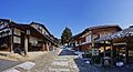 | 2,956 × 1,600(578 KB) | Panoramio upload bot | == {{int:filedesc}} == {{Information |description=Magome-juku(post town) , 馬籠宿 |date={{Taken on|2015-02-21}} |source=http://www.panoramio.com/photo/117275850 |author=[http://www.panoramio.com/user/238971?with_photo_id=117275850 z tanuki] |permis... |
文件用途
全域文件用途
以下其他wiki使用此文件:
- en.wikipedia.org上的用途
- es.wikipedia.org上的用途
- fr.wikipedia.org上的用途
- www.wikidata.org上的用途
此文件中包含有扩展的信息。这些信息可能是由数码相机或扫描仪在创建或数字化过程中所添加。
如果此文件的源文件已经被修改,一些信息在修改后的文件中将不能完全反映出来。

