Annis Mound and Village site
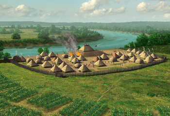
 Artist's conception of the Annis Mound and Village site circa 1250-1300 CE | |
| Location | Butler County, Kentucky, |
|---|---|
| Region | Western Coal Field |
| Coordinates | 37°17′23.42″N 86°45′10.4″W / 37.2898389°N 86.752889°W |
| History | |
| Founded | 800 CE |
| Abandoned | 1300 CE |
| Cultures | Middle Mississippian culture |
| Site notes | |
| Excavation dates | 1916, 1939–1940, 2002–2004 |
| Archaeologists | Clarence Bloomfield Moore, William Snyder Webb, Scott W Hammerstedt |
| Architecture | |
| Architectural styles | platform mound, palisade |
| Architectural details | Number of temples: 1 |
Annis Mound and Village site | |
| Area | 9 acres (3.6 ha) |
| NRHP reference No. | 85003182[1] |
| Added to NRHP | December 21, 1985 |
The Annis Mound and Village site (15BT2, 15BT20, and 15BT21) is a prehistoric Middle Mississippian culture archaeological site located on the bank of the Green River in Butler County, Kentucky, several miles northwest of Morgantown in the Big Bend region. It was occupied from about 800 CE to about 1300 CE.[2]

The site consisted of a platform mound (15 BT 2) measuring 33.5 metres (110 ft) square by 3.7 metres (12 ft) in height with special use structures at its summit. It was surrounded by the village area (15 BT 20) which was situated north of the generally east to west course of the Green River at the sites location. The village featured domestic structures and several sequential iterations of an encircling defensive palisade of upright tree trunks. The palisade was built three different times in the site's history; each one larger than its predecessor and encircling an expanded village area. A bastion was discovered in the northwest corner of the last version of the palisade. Agriculture was based on the cultivation of maize as a staple of the diet. Ceramics found at the site were typical Mississippian culture pottery; although a few sherds of high status pottery from the Cahokia site were discovered during excavations of the platform mound summit structure.[2]
The site also features a 1 metre (3.3 ft) in height 30 metres (98 ft) by 35 metres (115 ft) circular feature known as the Annis Sand Mound (15 BT 21) that dates from the Archaic period. This feature lies directly north of the village area and outside of the area encompassed by the palisade.[3]
A 9 acres (3.6 ha) area at the site was listed on the National Register of Historic Places as "Annis Mound and Village Site" in 1985.[1]
See also
[edit]- Angel Mounds
- Carlston Annis Shell Mound
- Kincaid Mounds State Historic Site
- List of Mississippian sites
References
[edit]- ^ a b "National Register Information System". National Register of Historic Places. National Park Service. November 2, 2013.
- ^ a b Lewis, R. Barry (1996). "Chapter 5: Mississippian Farmers". Kentucky Archaeology. University Press of Kentucky. pp. 135–137. ISBN 0-8131-1907-3.
- ^ Hammerstedt, Scott W. (2005). "Mississippian Status In Western Kentucky: Evidence From the Annis Mound". Southeastern Archaeology. 24 (1).
External links
[edit]- Middle Mississippian culture
- Archaic period in North America
- Mounds in Kentucky
- Native American history of Kentucky
- Archaeological sites in Kentucky
- Former populated places in Kentucky
- Geography of Butler County, Kentucky
- National Register of Historic Places in Butler County, Kentucky
- Archaeological sites on the National Register of Historic Places in Kentucky
