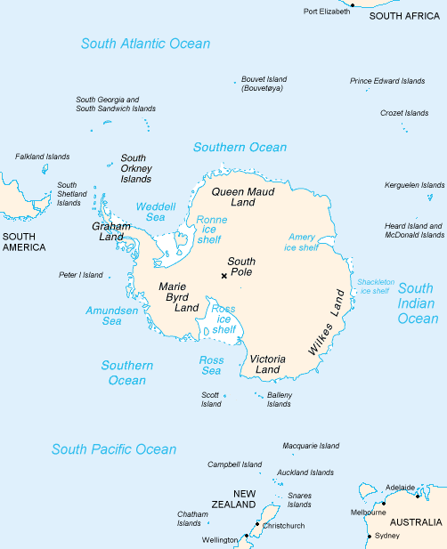
File:Antarctica Map.png
Appearance

Size of this preview: 488 × 600 pixels. Other resolutions: 195 × 240 pixels | 502 × 617 pixels.
Original file (502 × 617 pixels, file size: 52 KB, MIME type: image/png)
File history
Click on a date/time to view the file as it appeared at that time.
| Date/Time | Thumbnail | Dimensions | User | Comment | |
|---|---|---|---|---|---|
| current | 23:16, 15 December 2004 | 502 × 617 (52 KB) | Mschlindwein |
File usage
The following 39 pages use this file:
- 80th parallel south
- Adams Glacier (Wilkes Land)
- Bell Glacier
- Bibliography of Antarctica
- Blair Glacier
- Blodgett Iceberg Tongue
- Bond Glacier
- Conger Glacier
- De Haven Glacier
- Dibble Iceberg Tongue
- DuBeau Glacier
- Elliott Glacier
- Farthest South
- Filchner–Ronne Ice Shelf
- Freeman Glacier
- Frost Glacier
- Giacomo Bove
- Gilchrist Glacier
- Glenzer Glacier
- Holmes Glacier
- May Glacier
- Ocean fisheries
- Peterson Glacier
- Polynesian navigation
- Pourquoi Pas Glacier
- Remenchus Glacier
- Robinson Glacier
- Sandford Glacier
- Second German Antarctic Expedition
- Snedeker Glacier
- Southern Ocean
- Thompson Glacier
- Totten Glacier
- Tracy Glacier (Antarctica)
- Underwood Glacier
- Waldron Glacier
- Whittle Glacier
- Wikipedia:WikiProject Antarctica
- Portal:Oceans
Global file usage
The following other wikis use this file:
- Usage on an.wikipedia.org
- Usage on ar.wikipedia.org
- Usage on avk.wikipedia.org
- Usage on azb.wikipedia.org
- Usage on be.wikipedia.org
- Usage on bjn.wikipedia.org
- Usage on blk.wikipedia.org
- Usage on bn.wikipedia.org
- Usage on br.wikipedia.org
- Usage on bs.wikipedia.org
- Usage on ca.wikipedia.org
- Usage on cs.wikipedia.org
- Usage on da.wikipedia.org
- Usage on de.wikinews.org
- Usage on eo.wikipedia.org
- Usage on es.wikipedia.org
- Usage on es.wikibooks.org
- Usage on fa.wikipedia.org
- Usage on fi.wikipedia.org
- Usage on fy.wikipedia.org
- Usage on ga.wikipedia.org
- Usage on gl.wikipedia.org
View more global usage of this file.
