Category:Northwest Territory
Jump to navigation
Jump to search
English: The Territory Northwest of the River Ohio, more commonly known as the Northwest Territory, was an organized incorporated territory of the United States.
territory of the United States between 1787 and 1803  | |||||
| Upload media | |||||
| Instance of | |||||
|---|---|---|---|---|---|
| Location |
| ||||
| Capital | |||||
| Inception |
| ||||
| Dissolved, abolished or demolished date |
| ||||
| Replaces |
| ||||
| Replaced by | |||||
| Different from | |||||
 | |||||
Subcategories
This category has the following 12 subcategories, out of 12 total.
Media in category "Northwest Territory"
The following 53 files are in this category, out of 53 total.
-
-
121 Indiana St -County Jail (Historic) P6250255.jpg 3,072 × 2,304; 1.44 MB
-
-
-
1938 Ohio license plate.JPG 3,041 × 1,505; 719 KB
-
-
A map of the United States of North America LOC 2015588798-1.jpg 17,553 × 15,586; 40.95 MB
-
AlderGravestone.JPG 1,216 × 912; 173 KB
-
-
-
-
-
-
DSCN3504 ohiocompany e.JPG 600 × 573; 95 KB
-
ElectoralCollege1792-Large.png 675 × 636; 53 KB
-
Flickr - USCapitol - The First Thirteen Colonies.jpg 2,860 × 2,279; 3.93 MB
-
Governor Trumbull proclamation on the western lands 1783.jpg 1,011 × 1,536; 246 KB
-
-
Illinois history stories, for use in elementary schools (1910) (14593775397).jpg 1,740 × 2,988; 621 KB
-
-
-
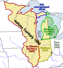
Indianaterr.PNG 484 × 529; 98 KB
-
LandingOfThePioneers.jpg 1,747 × 1,203; 1.4 MB
-
-
-
-
MELIOREM LAPSA LOCAVIT.JPG 2,872 × 2,687; 1.18 MB
-
Northwest Territory - USA (PSF).png 3,528 × 2,356; 2.76 MB
-
Northwest Territory locator map (1787).svg 512 × 505; 248 KB
-
Northwest Territory settlement 1938 U.S. stamp.1.jpg 344 × 406; 54 KB
-
Northwest territory.png 293 × 229; 27 KB
-
Northwest-territory-usa-1787.png 349 × 276; 61 KB
-
NW Native Tribes, 1792.png 884 × 860; 153 KB
-
Ordinance2 of 1787.jpg 1,302 × 830; 389 KB
-
Seal of the Northwest Territory.png 238 × 235; 26 KB
-
-
-
The American Soldier 1794 - U.S. Center of Military History.jpg 640 × 883; 275 KB
-
-
-
The upper territories of the United States - DPLA - 5c9c283cd74aeb6314a5faeba3863d1f.jpg 5,086 × 6,520; 3.32 MB
-
Toledowarphillipswar3.jpg 800 × 600; 317 KB
-
Books from the Library of Congress (IA travelsinamerica00ash).pdf 556 × 993, 378 pages; 25.34 MB
-
United States 1795-1796.png 1,000 × 677; 98 KB
-
United States 1796-1798.png 1,000 × 677; 97 KB
-
United States Central change 1785-04-19.png 2,046 × 1,321; 249 KB
-
United States Central change 1787-07-13.png 2,046 × 1,321; 245 KB
-
United States Central map 1784-05-12 to 1787-07-13.png 2,000 × 1,320; 249 KB
-
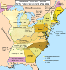
United States land claims and cessions 1782-1802.png 747 × 782; 145 KB
-
USA Gebietsansprüche und -abtretungen 1782–1802.png 747 × 782; 194 KB
-
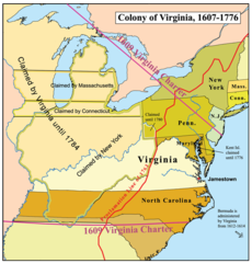
Virginiacolony.png 600 × 627; 291 KB
-
Wayne County by proclamation 1796.jpg 412 × 492; 43 KB
-
William Mark Young - Land Office of the Ohio Company - circa 1935.jpg 833 × 1,200; 833 KB


Categories:
- Historical regions of the United States
- 1787 establishments in the United States
- Former territories of the United States
- Westward expansion of the United States
- 1803 disestablishments in North America
- History of the Midwestern United States
- Congress of the Confederation
- States and territories established in 1787
- States and territories disestablished in 1803