Category:Road maps of Washington, D.C.
Jump to navigation
Jump to search
States of the United States: Alabama · Alaska · Arizona · Arkansas · California · Colorado · Connecticut · Delaware · Florida · Georgia · Hawaii · Idaho · Illinois · Indiana · Iowa · Kansas · Kentucky · Louisiana · Maine · Maryland · Massachusetts · Michigan · Minnesota · Mississippi · Missouri · Montana · Nebraska · Nevada · New Hampshire · New Jersey · New Mexico · New York · North Carolina · North Dakota · Ohio · Oklahoma · Oregon · Pennsylvania · Rhode Island · South Carolina · South Dakota · Tennessee · Texas · Utah · Vermont · Virginia · Washington · West Virginia · Wisconsin · Wyoming – Washington, D.C.
Puerto Rico
Puerto Rico
Media in category "Road maps of Washington, D.C."
The following 17 files are in this category, out of 17 total.
-
1967 freeway plan (5010173076).jpg 2,048 × 1,536; 364 KB
-
Capital Beltway Map Color.svg 564 × 489; 279 KB
-
DC Area Road Map 2.svg 3,000 × 3,000; 1.81 MB
-
DC Area Road Map With FontSubset.svg 3,000 × 3,000; 944 KB
-
DC Area Road Map.svg 3,000 × 3,000; 1.86 MB
-
DC freeway map.svg 7,107 × 5,930; 253 KB
-
DC Route 295 map.png 782 × 561; 45 KB
-
DCStreetsLabels.png 5,000 × 5,000; 2.92 MB
-
District of Columbia 1955 Yellow Book.jpg 800 × 971; 246 KB
-
I-295 (DC) map.svg 1,475 × 860; 140 KB
-
I-395 (DC) map.svg 1,475 × 860; 140 KB
-
I-395 DC.svg 750 × 738; 107 KB
-
Map of Interstate 66 Color.png 800 × 450; 86 KB
-
Morgan Boulevard Metro Map.png 425 × 510; 37 KB
-
StateNamedStreets.png 2,500 × 2,500; 807 KB
-
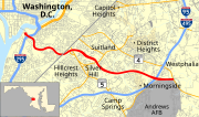
Suitland Parkway map.svg 1,004 × 591; 3.09 MB
-
WashingtonDCTopoMap.jpg 4,000 × 3,818; 4.29 MB


