File:Map-Hispanophone World 2000.png
Jump to navigation
Jump to search

Size of this preview: 800 × 352 pixels. Other resolutions: 320 × 141 pixels | 640 × 282 pixels | 1,427 × 628 pixels.
Original file (1,427 × 628 pixels, file size: 32 KB, MIME type: image/png)
Captions
Captions
Add a one-line explanation of what this file represents

Noticia
Español
Sólo se muestran los lugares con las tasas más altas de hablantes de español como lengua materna. Los lugares con bajos índices de hablantes nativos de español (por ejemplo, Francia) no se muestran en este mapa, ni las comunidades de hablantes no nativos en español. Este mapa muestra todas las partes del mundo donde el español es hablado. Tenga en cuenta que esto no es lo mismo que los países que se han considerado tradicionalmente como el núcleo de la Hispanidad (porque tienen el español como idioma oficial, y es la lengua principal del país, o porque han sido históricamente importante en la creación de la comunidad de hispanohablantes).
Sólo se muestran los lugares con las tasas más altas de hablantes de español como lengua materna. Los lugares con bajos índices de hablantes nativos de español (por ejemplo, Francia) no se muestran en este mapa, ni las comunidades de hablantes no nativos en español. Este mapa muestra todas las partes del mundo donde el español es hablado. Tenga en cuenta que esto no es lo mismo que los países que se han considerado tradicionalmente como el núcleo de la Hispanidad (porque tienen el español como idioma oficial, y es la lengua principal del país, o porque han sido históricamente importante en la creación de la comunidad de hispanohablantes).
English
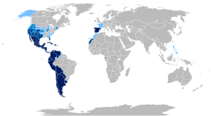
Only communities with the highest rates of speakers-of-Spanish-as-a-native-language are shown. Those with low rates of such communities of Spanish native speakers (for example, France) are not shown on this map, nor are communities of non-native Spanish speakers. This map shows all the parts of the World where Spanish or its créole languages are spoken. Note that this is not the same as the countries that are traditionally considered as the core of the Hispanidad (because they have Spanish as official language and it is the main language of the country, or because they have been historically important in the creation of the Hispanophone community).
Only communities with the highest rates of speakers-of-Spanish-as-a-native-language are shown. Those with low rates of such communities of Spanish native speakers (for example, France) are not shown on this map, nor are communities of non-native Spanish speakers. This map shows all the parts of the World where Spanish or its créole languages are spoken. Note that this is not the same as the countries that are traditionally considered as the core of the Hispanidad (because they have Spanish as official language and it is the main language of the country, or because they have been historically important in the creation of the Hispanophone community).
-
Hispanophone
-
Countries traditionally considered the core of the Hispanidad


Leyenda/legend
|
Países donde el español tiene estatus de lengua oficial.
Situación en los Estados Unidos de América:
Países o regiones donde el español es hablado sin reconocimiento oficial, o donde se hablan lenguas criollas de origen español, con o sin reconocimiento oficial.
NOTA: Para obtener información detallada sobre las fuentes de información utilizadas para la creación del mapa, véase su página de descripcción |
|
Countries where Spanish has official language status.
Situation in the United States of America:
Countries or regions where Spanish is spoken without official recognition, or where creoles of Spanish origin are spoken, with or without official recognition.
NOTE: For details on the sources of information used in creating the map, see this page for full description |
- Oficial
- EE.UU.:
- +25%
- 10-20%
- 5-10%
English: Countries and regions where the Spanish language is spoken without official recognition, or where Spanish-based créole languages are spoken with or without official recognition.
- NOTE: For detailed information about the sources taken to make the map, see its description page
Deutsch: Länder und Gebiete in denen Spanisch gesprochen wird ohne als offizielle Sprache anerkannt zu sein, oder in denen auf Spanisch basierende Kreol-Sprachen gesprochen werden.
- SIEHE: Für mehr Information über die Quellen der Karte, hier der Hauptartikel
Français : Pays et régions où l'espagnol est parlé sans avoir de reconnaissance officielle, ou où des créole d'origine espagnole sont parlés, avec ou sans reconnaissance officielle.
- Note : Pour obtenir de l'information détaillée sur les sources d'information utilisées pour la création de la carte, voir sa page de description
Italiano: Paesi o regioni dove il castigliano è parlato senza avere riconoscimento ufficiale, o dove si parlano creoli di origine castigliana, con o senza riconoscimento ufficiale.
- NOTA: Per ottenere informazioni dettagliate sulle fonti d'informazione utilizzate per la crazione della mappa, leggere qui.
Nederlands: Landen en regio's waar het Spaans gesproken wordt zonder officiële opname door de overheid, of waar Creoolse talen gebaseerd op het Spaans gesproken worden met of zonder officiële erkenning.
- N.B.: Voor gedetailleerde informatie m.b.t de bronnen die hierbij gebruikt zijn ter standkoming van deze kaart (vooralsnog alleen in het Engels beschikbaar) klik hier voor een verklarende beschrijving
Português: Países ou regiões onde o espanhol é falado sem reconhecimento oficial, ou onde se falam línguas crioulas de origem castelhana, com ou sem reconhecimento oficial.
- NOTA: Para obter informação detalhada sobre as fontes de informação utilizadas para a criação do mapa, veja sua página de descrição
Türkmençe: İspanyolca'nın resmi tanıma olmadan konuşulduğu ya da İspanyolca'ya dayanan kreole dillerinin resmi tanıma olarak ya da olmayarak konuşulduğu ülkeler ya da bölgeler.
- NOT: Haritanın yapımında yararlanılan kaynaklarla ilgili ayrıntılı bilgi için anlatım sayfasına bakınız
Gascon: Peis e regions ond l'espanhòu ei parlat xentz ua reconeixença oficiau, o ond creoles d'origina espanhòla, dab o xentz reconeixença oficiau.
- NÒTA: Tà-d aver ua informacion detalhada suus hont d'informacions utilisadas tà la creacion de la carta, véder la soa paja de descripcion
Sources for the legend
Countries where Spanish has official status. Includes:
- In Europe:
- In Africa:
- Ceuta (Spain)
- Melilla (Spain)
- Canary Islands (Spain)
- Equatorial Guinea (Equatorial Guinean constitution of 1995; 4th article)
- In the Americas:
- Argentina
- Bolivia
- Chile
- Colombia (Colombian Constitution of 1991; 10th article)
- Costa Rica (Costa Rican Constitution of 1949; 76th article)
- Cuba (1992 Cuban Constitution; 2nd article)
- Ecuador (1998 Equatorian Constitution; 1st article)
- El Salvador (1987 Salvadoran Constitution; 62nd article)
- Guatemala (Guatemalan Constitution of 1993; 143rd article)
- Honduras (Honduran Constitution of 1982; 6th article)
- México
- Nicaragua
- Panamá (Panamanian Constitution of 1972; 7th article)
- Paraguay (Paraguayan Constitution of 1992; 140th article)
- Perú (Peruvian Constitution of 1993; 48th article)
- Puerto Rico
- República Dominicana
- Uruguay
- Venezuela (Venezuelan Constitution of 1999; 9th article)
- In Oceania:
- Easter Island (Chile)
Situation in the United States of America:
States of the U.S. where Spanish has no official status but is spoken by 25% or more of the population (2000 Census):
- New Mexico (42.1%)
- California (32.4%)
- Texas (32.0%)
- Arizona (25.3%)
States of the U.S. where Spanish has no official status but is spoken by 10-20% of the population (2000 Census):
- Nevada (19.7%)
- Colorado (17.1%)
- Illinois (12.3%)
- Florida (16.8%)
- New York (15.1%)
- New Jersey (13.3%)
States of the U.S. where Spanish has no official status but is spoken by 5-9.9% of the population (2000 Census):
- Connecticut (9.4%)
- Utah (9.0%)
- Rhode Island (8.7%)
- Oregon (8.0%)
- Idaho (7.9%)
- Washington (7.5%)
- Kansas (7.0%)
- Massachusetts (6.8%)
- Wyoming (6.4%)
- Nebraska (5.5%)
- Georgia (5.3%)
- Oklahoma (5.2%)
Countries and regions where the Spanish language is spoken without official recognition, or where Spanish-based créole languages are spoken with or without official recognition. Includes:
- In Europe (the Iberian Peninsula):
- Andorra: 71,822 inhabitants (CIA WF). Spanish is taught at schools, and almost the entire population speaks it.
- In the Caribbean:
- Belize: 130,000 speakers of Spanish (Source).
- Trinidad and Tobago: 4,100 speakers of Spanish (Source), mainly in fishing villages and communities of the southern peninsula, of a total population of 1,305,000, but given special status by the Government.
NOTE: The labels given to the sources of information provided in the legend are of four different types:
- The label "XXXX Census" means that the source comes from an official census.
- The label "CIA WF" means that that the source comes from the CIA World Factbook.
- The label "Source: [Official Website]" means that the source comes from an official website.
- The simple label "Source" means that that the source comes from somewhere else, and therefore it should be replaced by a reliable source.

|
File:Hispanophone global world map language 2.svg is a vector version of this file. It should be used in place of this PNG file when not inferior.
File:Map-Hispanophone World 2000.png → File:Hispanophone global world map language 2.svg
For more information, see Help:SVG. |
 |
Licensing
| This work has been released into the public domain by its author, Onofre_Bouvila. This applies worldwide. In some countries this may not be legally possible; if so: |
File history
Click on a date/time to view the file as it appeared at that time.
| Date/Time | Thumbnail | Dimensions | User | Comment | |
|---|---|---|---|---|---|
| current | 23:19, 16 September 2011 | 1,427 × 628 (32 KB) | Adeuagur (talk | contribs) | Reverted to version as of 09:28, 21 August 2011 | |
| 12:07, 3 September 2011 | 1,427 × 628 (55 KB) | The Ogre (talk | contribs) | Reverted to version as of 13:10, 17 August 2011 | ||
| 09:28, 21 August 2011 | 1,427 × 628 (32 KB) | Iamiyouareyou (talk | contribs) | Removed orange and added Philippines in light blue shade to conform with Map description. | ||
| 09:17, 21 August 2011 | 1,427 × 628 (62 KB) | Iamiyouareyou (talk | contribs) | Reverted to version as of 16:53, 6 August 2011, | ||
| 13:10, 17 August 2011 | 1,427 × 628 (55 KB) | The Ogre (talk | contribs) | Rv unsourced delirium - Reverted to version as of 12:35, 18 July 2011 | ||
| 16:53, 6 August 2011 | 1,427 × 628 (62 KB) | Iamiyouareyou (talk | contribs) | Alta Naranja para: Áreas donde se habla español con cierta significación de proporciones menores. Added Orange for: Areas where Spanish is spoken with some significance of minor proportions | ||
| 16:48, 6 August 2011 | 1,427 × 628 (62 KB) | Iamiyouareyou (talk | contribs) | Alta Naranja para: Áreas donde se habla español con cierta significación de proporciones menores. Added Orange for: Areas where Spanish is spoken with some significance of minor proportions | ||
| 12:35, 18 July 2011 | 1,427 × 628 (55 KB) | Tariq ibn Ziyad (talk | contribs) | Reverted to version as of 12:24, 9 March 2011 Undo adding of Morocco, Western Sahara, and the Philippines. See discussion. | ||
| 18:27, 13 July 2011 | 1,427 × 628 (56 KB) | Fobos92 (talk | contribs) | . | ||
| 12:24, 9 March 2011 | 1,427 × 628 (55 KB) | The Ogre (talk | contribs) | Reverted to version as of 02:22, 25 January 2011 - Spanish is NOT spoken in the Philippines - see talk |
You cannot overwrite this file.
File usage on Commons
The following 23 pages use this file:
- Atlas of Spain
- Atlas of languages
- User:The Ogre
- User talk:Al-Andalus
- Commons:Village pump/Archive/2006/04
- File:Hispanidad.PNG
- File:Map-Hispanophone World.png (file redirect)
- File:Map-Romance Language World.png
- Commons:Village pump/Archive/2006/04
- User talk:Al-Andalus
- Atlas of languages
- Atlas of Spain
- File:Hispanidad.PNG
- File talk:Hispanidad.PNG
- User:The Ogre
- File talk:Distribución geográfica del idioma españolpy.png
- File:Map-Hispanophone World 2000.png
- File talk:Lenguas iberorromance.png
- File:Map-Hispanophone World 2000.png
- File:Map-Romance Language World.png
- File talk:Distribución geográfica del idioma españolpy.png
- File talk:Hispanidad.PNG
- File talk:Lenguas iberorromance.png
File usage on other wikis
The following other wikis use this file:
- Usage on en.wikipedia.org
- Usage on es.wikipedia.org
- Usage on he.wikipedia.org
- Usage on id.wikipedia.org
- Usage on it.wikivoyage.org
- Usage on nl.wikipedia.org
- Usage on no.wiktionary.org