File:Struve Geodetic Arc-fr.svg
Jump to navigation
Jump to search

Size of this PNG preview of this SVG file: 543 × 599 pixels. Other resolutions: 217 × 240 pixels | 435 × 480 pixels | 696 × 768 pixels | 928 × 1,024 pixels | 1,856 × 2,048 pixels | 975 × 1,076 pixels.
Original file (SVG file, nominally 975 × 1,076 pixels, file size: 657 KB)
Captions
Captions
Add a one-line explanation of what this file represents
| Description |
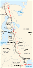
Français : Carte de l'arc géodésique de Struve. Les 34 points rouges correspondent aux sites de mesure classés au patrimoine mondial de l'Unesco
English: Map of the Struve Geodetic Arc. The 34 red points are the places registered in the UNESCO World Heritage Site
Deutsch: Karte des Struve-Bogens. Geodätische Triangulation von Hammerfest bis ans Schwarze Meer. 34 rote Punkte sind UNESCO World Heritage Site |
||||||||
| Date | |||||||||
| Source | Image:Map of the Struve Geodetic Arc.jpg by Badock | ||||||||
| Author | historicair 23:58, 13 September 2007 (UTC) | ||||||||
| Permission (Reusing this file) |
I, the copyright holder of this work, hereby publish it under the following licenses:
This file is licensed under the Creative Commons Attribution-Share Alike 2.5 Generic, 2.0 Generic and 1.0 Generic license.
You may select the license of your choice. |
||||||||
| Other versions |
[]
|


| This SVG file contains embedded text that can be translated into your language, using any capable SVG editor, text editor or the SVG Translate tool. For more information see: About translating SVG files. |
File history
Click on a date/time to view the file as it appeared at that time.
| Date/Time | Thumbnail | Dimensions | User | Comment | |
|---|---|---|---|---|---|
| current | 08:40, 18 October 2022 | 975 × 1,076 (657 KB) | Рагин1987 (talk | contribs) | Small correction | |
| 23:58, 13 September 2007 | 975 × 1,076 (635 KB) | Historicair (talk | contribs) | {{Information |Description={{fr|Arc géodésique de Struve}} {{en|Struve Geodetic Arc}} |Source=Image:Map of the Struve Geodetic Arc.jpg by Badock |Date=14/09/2007 |Author=~~~~ |Permission={{self2|GFDL|cc-by-sa-2.5,2.0,1.0}} |other_ve |
You cannot overwrite this file.
File usage on Commons
The following 19 pages use this file:
- Struve Geodetic Arc
- User:Magog the Ogre/Multilingual legend/2022 October 11-20
- User:Makele-90/recent uploads/Protected areas of Finland/2022 October
- File:Struve Geodetic Arc-fr.svg
- File:Struve Geodetic Arc-he.svg
- File:Struve Geodetic Arc-zoom-af.svg
- File:Struve Geodetic Arc-zoom-cs.svg
- File:Struve Geodetic Arc-zoom-de.svg
- File:Struve Geodetic Arc-zoom-en.svg
- File:Struve Geodetic Arc-zoom-fr.svg
- File:Struve Geodetic Arc-zoom-ka.svg
- File:Struve Geodetic Arc-zoom-lt.svg
- File:Struve Geodetic Arc-zoom-lv.svg
- File:Struve Geodetic Arc-zoom-pl.svg
- File:Struve Geodetic Arc-zoom-ru.svg
- File:Struve Geodetic Arc-zoom-sv.svg
- File:Struve Geodetic Arc-zoom-vi.svg
- File:Struve meridiaan.svg
- Template:Other versions/Struve Geodetic Arc
File usage on other wikis
The following other wikis use this file:
- Usage on be-tarask.wikipedia.org
- Usage on bs.wikipedia.org
- Usage on ca.wikipedia.org
- Usage on de.wikipedia.org
- Usage on en.wikipedia.org
- Usage on es.wikipedia.org
- Usage on eu.wikipedia.org
- Usage on fr.wikipedia.org
- Usage on he.wikipedia.org
- Usage on hu.wikipedia.org
- 2005 új világörökségi helyszínei
- Svédország világörökségi helyszínei
- Lettország világörökségi helyszínei
- Észtország világörökségi helyszínei
- Moldova világörökségi helyszínei
- Norvégia világörökségi helyszínei
- Fehéroroszország világörökségi helyszínei
- Finnország világörökségi helyszínei
- Litvánia világörökségi helyszínei
- Szerkesztő:Oroszország világörökségi helyszínei
- Usage on mt.wikipedia.org
- Usage on ro.wikipedia.org
- Usage on uk.wikipedia.org