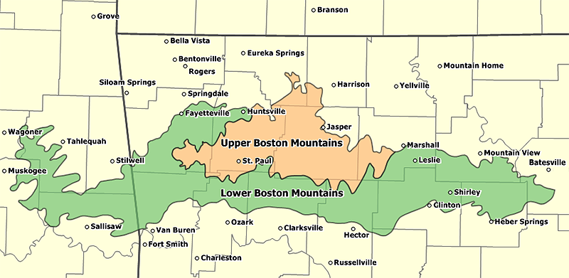
Boston Mountains
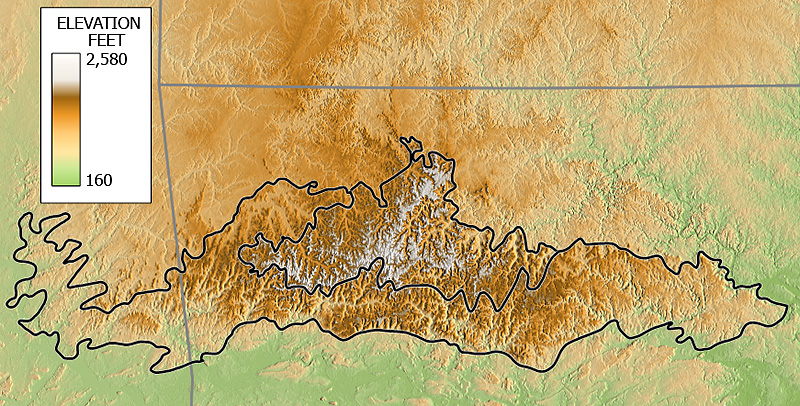
The Boston Mountains are a high and deeply dissected plateau located in northern Arkansas and eastern Oklahoma. The Oklahoma portion of the range is locally referred to as the Cookson Hills. The rocks of the region are essentially little disturbed, flat-lying sedimentary layers of the Paleozoic age. The highest ridges and peaks are capped by Pennsylvanian sandstone and shale. The deeply eroded valleys are cut into Mississippian limestone and below that layer the Ordovician dolomite.
The Boston Mountains form the southwestern part of the Ozark plateau where they are the highest and most rugged portion of the Ozarks. Summits can reach elevations of just over 2,560 feet with valleys 500 to 1,550 feet deep. Turner Ward Knob (TWK) is the highest named peak. Located in western Newton County, Arkansas, its elevation is 2,463 feet. Nearby, five unnamed peaks have elevations at or slightly above 2,560 feet. Two of these highest peaks are located 2.2 miles west of TWK, one being the location of the Buffalo Lookout fire tower. The other three highest peaks are located 4-5 miles SSW of TWK along Arkansas State Highway 16.
The Boston Mountains are the source of rivers and streams that flow out from the mountains in all directions. Within a 3 mile radius of a point just west of the summits discussed above are located the sources of the White River, the Buffalo River, the Kings River, War Eagle Creek, and Little Mulberry Creek. Other rivers and streams having their headwaters in the Boston Mountains include the Illinois River, the Mulberry River, Lee Creek, Frog Bayou, Big Piney Creek, Illinois Bayou, and the Little Red River. To the south, the Arkansas River valley separates the Boston Mountains from the Ouachita Mountains.
In Arkansas the Boston Mountains are found in the following counties: Boone, Carroll, Cleburne, Conway, Crawford, Franklin, Independence, Johnson, Madison, Newton, Pope, Searcy, Stone, Van Buren, and Washington.
In Oklahoma the Boston Mountains are found in these counties: Adair, Cherokee, Muskogee, Sequoyah, and Wagoner.
[NAD83 geographic coordinates for TWK are N35.8631°, W093.4544°. Coordinates for the 5 unnamed highest peaks are N35.8637°, W093.4931°; N35.8607°, W093.4935°; N35.8151°, W093.4968°; N35.8126°, W093.4984°; and N35.7990°, W093.5005°]
External link