Carnac stones
This article includes a list of general references, but it lacks sufficient corresponding inline citations. (May 2019) |


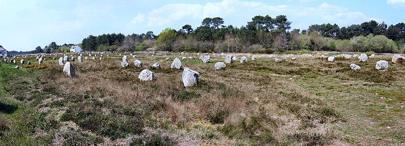
The Carnac stones (Breton: Steudadoù Karnag) are an exceptionally dense collection of megalithic sites near the south coast of Brittany in northwestern France, consisting of stone alignments (rows), dolmens (stone tombs), tumuli (burial mounds) and single menhirs (standing stones). More than 3,000 prehistoric standing stones were hewn from local granite and erected by the pre-Celtic people of Brittany and form the largest such collection in the world.[1] Most of the stones are within the Breton municipality of Carnac, but some to the east are within neighboring La Trinité-sur-Mer. The stones were erected at some stage during the Neolithic period, probably around 3300 BCE, but some may date to as early as 4500 BCE.[2]
Although the stones date from 4500–3300 BCE, modern myths associated them with 1st century CE Roman and later Christian occupations. A Christian myth associated with the stones held that they were pagan soldiers in pursuit of Pope Cornelius when he turned them to stone.[3][4][5] Brittany has its own local versions of the Arthurian cycle. Local tradition similarly claims that the reason they stand in such perfectly straight lines is that they are a Roman legion turned to stone by Merlin.
In recent centuries, many of the sites have been neglected, with reports of dolmens being used as sheep shelters, chicken sheds or even ovens.[6] Even more commonly, stones have been removed to make way for roads, or as building materials. The continuing management of the sites remains a controversial topic.[1][7]
According to Neil Oliver's BBC documentary A History of Ancient Britain,[8] the alignments would have been built by hunter-gatherer people ("These weren't erected by Neolithic farmers, but by Mesolithic hunters"). That would place them in a different category from Stonehenge in England, which has been claimed to be the work of Early European Farmers.[9] The question of which people Carnac stones are to be attributed to is still debated.[10]
Alignments


There are three major groups of stone rows – Ménec, Kermario and Kerlescan. They may have once formed a single group but have been split up as stones were removed for other purposes.
The standing stones are made of weathered granite from local outcroppings that once extensively covered the area.[11]
Ménec alignments
Eleven converging rows of menhirs stretching for 1,165 by 100 metres (3,822 by 328 feet). There are what Alexander Thom considered to be the remains of stone circles at either end. According to the tourist office there is a "cromlech containing 71 stone blocks" at the western end and a very ruined cromlech at the eastern end. The largest stones, around 4 metres (13 feet) high, are at the wider, western end; the stones then become as small as 0.6 metres (2 feet 0 inches) high along the length of the alignment before growing in height again toward the extreme eastern end.
Kermario alignment
This fan-like layout recurs a little further along to the east in the Kermario (House of the Dead)[12] alignment. It consists of 1029 stones[13] in ten columns, about 1,300 m (4,300 ft) in length.[citation needed] A stone circle to the east end, where the stones are shorter, was revealed by aerial photography.[14]
Kerlescan alignments
A smaller group of 555 stones, further to the east of the other two sites. It is composed of 13 lines with a total length of about 800 metres (2,600 ft), ranging in height from 80 cm (2 ft 7 in) to 4 m (13 ft).[15] At the extreme west, where the stones are tallest, there is a stone circle which has 39 stones. There may also be another stone circle to the north.[citation needed]
Petit-Ménec alignments
A much smaller group, further east again of Kerlescan, falling within the commune of La Trinité-sur-Mer. These are now set in woods, and most are covered with moss and ivy.[16]
Tumuli
There are several tumuli, mounds of earth built up over a grave. In this area, they generally feature a passage leading to a central chamber which once held neolithic artifacts.
Three exceptionally large burial mounds are known from the Carnac and Gulf of Morbihan area, dating from the mid-5th millennium BC and known collectively as "Carnacéen tumuli": Saint-Michel, Tumiac and Mané-er-Hroëk.[17] Each of these tumuli contained a megalithic burial chamber, containing the burial of only one individual, along with numerous large polished stone axes and jewellery made from callaïs (variscite).[18] Scientific analyses have shown that many of the axes are made of jadeite from the Italian Alps, whilst the callaïs originated in south-western Iberia. Archaeological evidence further indicates that the callais was brought from Iberia by boat, across the Bay of Biscay, rather than along the coast or overland. Some of the large polished jade axes would have taken up to a thousand hours to produce, on top of the time required to quarry the material and transport it to Carnac. The extraordinary nature of these burials, the scale of the tumuli, the distant exchange networks and effort involved, all indicate that these were the burials of extremely important elite individuals, who some researchers have described as "divine kings".[19][20]
Saint-Michel

The tumulus of Saint-Michel was constructed between 5000 BCE and 3400 BCE. At its base it is 125 by 60 m (410 by 197 ft), and is 12 m (39 ft) high. It required 35,000 cubic metres (46,000 cu yd) of stone and earth. Its function was a tomb for the members of the ruling class. It contained various funerary objects, such as 15 stone chests, large jade axes, pottery, and callaïs (turquoise and variscite) jewellery, most of which are currently held by the Museum of Prehistory of Carnac.[21] It was excavated in 1862 by René Galles with a series of vertical pits, digging down 8 m (26 ft). Le Rouzic also excavated it between 1900 and 1907, discovering the tomb and the stone chests.[22]
A chapel was built on top in 1663 and was rebuilt in 1813, before being destroyed in 1923. The current building is an identical reconstruction of the 1663 chapel, built in 1926.
Tumiac

The tumulus of Tumiac is located in Arzon, in the Rhuys peninsula, south of the Gulf of Morbihan. It is also known as 'Caesar's mound' because, according to local legend, it served as an observatory for Julius Caesar during his war against the Veneti in 56 BC.
The site was excavated in 1853. The crater visible at the top of the tumulus corresponds to the vertical hole made at the time for its exploration. It was the subject of new excavations and work in 1934, which brought to light several secondary burials.
The tumulus, circular/elliptical in shape, is made up of layers of clay. It measures 50m in diameter and 15m in height. It contains a central rectangular burial chamber 4.40m long, 2.40m wide and 1.75m high. This chamber is made up of three monolithic supports and is covered with a quartz slab 4.80m long. It had a wooden floor and two engraved side slabs. The funerary chamber contained rich furniture consisting of 11 jadeite axes, 26 fibrolith axes and 249 callaïs beads. These objects are kept in the Archaeological Museum of Vannes. According to carbon-14 dating, the tumulus of Tumiac was erected between 4790 and 4530 BC.
The tumulus of Tumiac has been classified as a historical monument since 1923.
Mané-er-Hroëk

The Tumulus of Mané-er-Hroëk (also known as the Tumulus du Ruyk is located in Locmariaquer, Morbihan, immediately west of the hamlet of Er-Hroueg and about 1 km northeast of the Pierres Plates dolmen.
The tumulus comprises a rectangular burial vault of about 5m by 3m, covered with two roofing slabs, supporting a mound about 100m long and 60m wide. The tumulus rises to approximately 15m above sea level, or almost 8m above the natural ground. The current entrance, with a staircase, is a modern addition. An engraved stele, found broken into three pieces, stands next to the entrance.
The tumulus was excavated in 1863 by the Polymathic Society of Morbihan. These excavations led to the discovery of the vault and stele and brought to light 106 precious stone axes (the largest of which measures 46cm), 49 callaïs beads and 9 callaïs pendants. These objects were subsequently deposited in the Archeological Museum of Vannes. The tumulus has been classified as a historical monument since 1889.
Moustoir
47°36′43″N 3°03′39″W / 47.6119°N 3.0608°W[23] Also known as Er Mané, it is a chamber tomb 85 m (279 ft) long, 35 m (115 ft) wide, and 5 m (16 ft) high. It has a dolmen at the west end, and two tombs at the east end.[21] A small menhir, approximately 3 m (10 ft) high, is nearby.
Grave goods

-
Callaïs from Saint-Michel
-
Callaïs from Tumiac
-
Tumiac
-
Tumiac
-
Mané-er-Hroëck
-
Mané-er-Hroëck
-
Jadeite axes
-
Jadeite and eclogite axes from the Saint-Michel tumulus
-
Stone rings
-
Jade axes
-
Broken stone axes
-
Polished stone axes


Dolmens

There are several dolmens scattered around the area. These dolmens are generally considered to have been tombs; however, the acidic soil of Brittany has eroded away the bones. They were constructed with several large stones supporting a capstone, then buried under a mound of earth. In many cases, the mound is no longer present, sometimes due to archeological excavation, and only the large stones remain, in various states of ruin.
Er-Roc'h-Feutet
North, near the Chapelle de La Madeleine. Has a completely covered roof.
La Madeleine
47°37′15″N 3°02′54″W / 47.6208°N 3.0482°W[24] A large dolmen measuring 12 by 5 m (39 by 16 ft), with a 5 m (16 ft) long broken capstone.[6] It is named after the nearby Chapelle de La Madeleine, which is still used.
Kercado

A rare dolmen still covered by its original cairn. South of the Kermario alignments, it is 25 to 30 metres (82–98 ft) wide, 5 m (16 ft) high, and has a small menhir on top. Previously surrounded by a circle of small menhirs 4 m (13 ft) out,[22] the main passage is 6.5 m (21 ft) long and leads to a large chamber where numerous artifacts were found, including axes, arrowheads, some animal and human teeth, some pearls and sherds, and 26 beads of a unique bluish Nephrite gem. It has some Megalithic art carved on its inner surfaces in the form of serpentines and a human-sized double-axe symbol carved in the underside of its main roof slab. In ancient cultures, the axe and more precisely the bi-pennis used to represent the lightning powers of divinity. It was constructed around 4600 BC and used for approximately 3,000 years.[22]
Mané Brizil
Kerlescan
A roughly rectangular mound, with only one capstone remaining. It is aligned east-to-west, with a passage entrance to the south.[25]
Kermarquer
On a small hill, has two separate chambers.
Mané-Kerioned
(Pixies' mound or Grotte de Grionnec[22]):A group of three dolmens with layout unique in Brittany,[22] once covered by a tumulus. Whereas most groups of dolmens are parallel, these are arranged in a horseshoe. The largest of the three is at the east, 11 metres (36 ft).[21]
Crucuno

A "classic" dolmen, with a 40-tonne (44-short-ton), 7.6-metre (24 ft 11 in) tablestone resting on pillars roughly 1.8 m (5 ft 11 in) high. Prior to 1900, it was connected by a passage making it 24 m (79 ft) long.[22]
Crucuno stone rectangle
47°37′30″N 3°07′19″W / 47.625°N 3.122°W: A classic 3, 4, 5 rectangle of 21 menhirs varying in height from 0.91 metres (3.0 ft) to 2.4 metres (7.9 ft) that is aligned along its diagonal to the midsummer sunrise. Alexander Thom suggested it measured forty by thirty of his megalithic yards.[26]
Other formations


There are some individual menhirs and at least one other formation which do not fit into the above categories.
Manio quadrilateral
An arrangement of stones to form the perimeter of a large rectangle. Originally a "tertre tumulus" with a central mound, it is 37 m (121 ft) long, and aligned to east of northeast. The quadrilateral is 10 m (33 ft) wide to the east, but only 7 m (23 ft) wide at the west.[27]
Manio giant
47°36′11″N 3°03′22″W / 47.603°N 3.056°W[28] Near the quadrilateral is a single massive menhir, now known as the "Giant". Over 6.5 m (21 ft) tall, it was re-erected around 1900 by Zacharie Le Rouzic,[22] and overlooks the nearby Kerlescan alignment.[29]
Excavation and analysis

From the 1720s increasing interest was shown in these features.[30] In 1796, for example, La Tour d'Auvergne attributed them to druidic gatherings.[22] In 1805, A. Maudet de Penhoët claimed they represented stars in the sky.[22]
Englishmen Francis Ronalds and Alexander Blair made a detailed survey of the stones in 1834.[31] Ronalds created the first accurate drawings of many of them with his patented perspective tracing instrument, which were printed in a book Sketches at Carnac (Brittany) in 1834.[32]
Miln and Le Rouzic
The first extensive excavation was performed in the 1860s by Scottish antiquary James Miln (1819–1881), who reported that by then fewer than 700 of the 3,000 stones were still standing.[33] Towards 1875, Miln engaged a local boy, Zacharie Le Rouzic (1864–1939), as his assistant, and Zacharie learnt archaeology on the job. After Miln's death, he left the results of his excavations to the town of Carnac, and the James Miln Museum was established there by his brother Robert to house the artifacts. Zacharie became the director of the Museum and, although self-taught, became an internationally recognised expert on megaliths in the region. He too left the results of his work to the town, and the museum is now named Le Musée de Préhistoire James Miln – Zacharie le Rouzic.[34][35]
Other theories
In 1887, H. de Cleuziou argued for a connection between the rows of stones and the directions of sunsets at the solstices.[22]
Among more recent studies, Alexander Thom worked with his son Archie from 1970 to 1974 to carry out a detailed survey of the Carnac alignments, and produced a series of papers on the astronomical alignments of the stones as well as statistical analysis supporting his concept of the megalithic yard.[34][36] Thom's megalithic yard has been challenged.[37][38]
There are also general theories on the use of the stones as astronomical observatories, as has been claimed for Stonehenge. According to one such theory, the massive menhir at nearby Locmariaquer was linked to the alignments for such a purpose.[15]
Management

The Musée de Préhistoire James Miln – Zacharie le Rouzic is at the centre of conserving and displaying the artefacts from the area.[35] It also contains the "world's largest collection [of] prehistoric[al] exhibits"[21] with over 6,600 prehistoric objects from 136 different sites.
The monuments themselves were listed and purchased by the State at the start of the 20th century to protect them against quarrymen, and while this was successful at the time, in the middle of the century, redevelopment, changes to agricultural practices and increasing tourism bringing visitors to the stones led to rapid deterioration. The Ministère de la Culture et de la Communication (Heritage Ministry) re-examined the issue starting in 1984, and subsequently set up the ‘Mission Carnac’ in 1991 with the aim of rehabilitating and developing the alignments. This involved restricting public access, launching a series of scientific and technical studies, and producing a plan for conservation and development in the area.[39]
As with the megalithic structure of Stonehenge in England, management of the stones can be controversial. Since 1991, the main groups of stone rows have been protected from the public by fences "to help vegetation growth",[21] preventing visits except by organised tours. They are open during winter, however.[40] When James Miln studied the stones in the 1860s, he reported that fewer than 700 of the 3,000 stones were still standing, and subsequent work during the 1930s and 1980s (using bulldozers) rearranged the stones, re-erecting some, to make way for roads or other structures. In 2002, protesters invaded the site, opening the padlocks and allowing tourists free entry.[33] In particular, the group Collectif Holl a gevred (French and Breton for "the everyone-together collective") occupied the visitor centre for the Kermario alignment, demanding an immediate stop to current management plans and local input into further plans.[41]
In recent years, management of the site has also experimented with allowing sheep to graze among the stones, in order to keep gorse and other weeds under control.[42]
See also
References
Notes
- ^ a b "Megaliths of Carnac: Introduction". menhirs.tripod.com. Retrieved 2010-01-07.
- ^ "Carnac Stones, Brittany". Sacred Destinations Travel Guide. Retrieved 2006-05-17.
- ^ "Marvelling at Carnac's stones". News.therecord.com. 2008-03-08. Archived from the original on 2012-04-15. Retrieved 2009-05-05.
- ^ "France Holidays, Brittany". Franceholidays.co.uk. Archived from the original on 2011-10-03. Retrieved 2009-05-05.
- ^ "Why are Carnac Stones Called Megaliths?". Big Site of Amazing Facts. Retrieved 2010-01-07.
- ^ a b TheCaptain (3 January 2005). "La Madeleine dolmen Burial Chamber (Dolmen)". The Megalithic Portal and Megalith Map. Archived from the original on 4 February 2012. Retrieved 2006-05-17.
- ^ "Megaliths of Carnac: Standing Stones / Menhirs". megaliths.sherwoodonline.de. Retrieved 2010-01-07.
- ^ "A History of Ancient Britain, Series 1, Age of Ancestors". www.bbc.co.uk (BBC Two). Retrieved 2020-11-09.
- ^ "Stonehenge built by descendants of early immigrants, study finds". The Independent. 2019-04-16. Retrieved 2020-11-09.
- ^ Laporte, Luc; Roux, Charles-Tanguy Le (2005). Bâtisseurs du Néolithique (in French). Maison des Roches.
- ^ Mens, Emmanuel (2015). "Refitting megaliths in western France". Antiquity. 82 (315): 25–36. doi:10.1017/S0003598X00096411. S2CID 163056484. ProQuest 217542367.
- ^ "Mané Kermario". Archived from the original on 2006-09-23. Retrieved 2006-05-17.
- ^ Holidays in Brittany Archived October 27, 2005, at the Wayback Machine
- ^ "Kermario". Myweb.tiscali.co.uk. Archived from the original on 2007-10-24. Retrieved 2009-05-05.
- ^ a b (in French) http://www.dinosoria.com/dolmen_menhir.htm
- ^ "Petit Ménec". Myweb.tiscali.co.uk. Archived from the original on 2012-09-29. Retrieved 2009-05-05.
- ^ "Paysages de Megalithes de Carnac et du Sud Morbihan". www.megalithes-morbihan.fr.
- ^ Cassen, Serge; Rodríguez-Rellán, Carlos; Fábregas Valcarce, Ramon; Grimaud, Valentin; Pailler, Yvan; Schulz Paulsson, Bettina (2019). "Real and ideal European maritime transfers along the Atlantic coast during the Neolithic". Documenta Praehistorica. 46: 308–325. doi:10.4312/dp.46.19.
There are, in the Morbihan region of western France (Brittany), more than one hundred earthen mounds (circular or elongated) containing individual or multiple burials dug into pits or arranged in stone or wood cists. … Among such monuments, three stand out for their isolation in the landscape, gigantic proportions and for the quantity and quality of the objects made of jade and callaïs they contained. These funerary spaces have no structured access and preserved the remains of only one individual. The volumes of their tumuli are extraordinary: Saint-Michel in Carnac (35,000m3), Tumiac in Arzon (16,000m3) and Mané er Hroëck in Locmariaquer (14,600m3); while their maximum height rises between 10 and 15m above the ground. The current state of knowledge suggests Mané er Hroëck was the oldest of the three, followed by Tumiac and – finally – Saint-Michel. The last two have radiocarbon dates available (about 4500 cal BC), obtained from diverse samples and by different researchers.
- ^ Petrequin, Pierre; Cassen, Serge; Errera, Michel; Klassen, Lutz; Sheridan, Alison (2012). "29: Sacred things… the idealised functions of Alpine jade objects in western Europe". JADE – Grandes Haches Alpines du Néolithique Européen, Ve et IVe Millénaires av. J.C. pp. 1356–1357. ISBN 978-2848674124.
The status of the individuals who were interred in the massive mounds in the Carnac area of the Gulf of Morbihan, accompanied by numerous large Alpine axeheads and by other objects imported over long distances, is therefore all the more exceptional and demands to be explained. ... The evidence encourages us to regard this society – which produced the earliest megalithic architecture in Europe around the middle of the 5th millennium, together with a whole repertoire of symbolic imagery engraved on extraordinary standing stones, as one which was markedly inegalitarian, with some men having acquired an intermediary status between the elite and the supernatural powers. Such individuals would have been theocrats, 'divine kings'.
- ^ Garrow, Duncan; Wilkin, Neil (June 2022). The World of Stonehenge. British Museum Press. pp. 145–147. ISBN 9780714123493.
From around 6,800 years ago, Brittany saw the construction of massive monuments, including burial mounds and the famous multi-stone alignments at Carnac as well as the erection of enormous menhirs (standing stones). Remarkable objects made from imported materials have been found in these tombs … One of the most impressive monuments is Tumulus Saint-Michel, a burial mound 125 metres long, 60 metres wide and 10 metres high, so large it now has a medieval chapel on top. Excavations there in the nineteenth century revealed thirty-nine polished stone axes, eleven of which were made of Alpine jadeitite (jade), along with several pendants and over a hundred beads made of Iberian variscite stone. It is likely that these objects were buried with a single person who was incredibly important to the community of mourners.
- ^ a b c d e "Office de Tourisme de Carnac". 2006-07-03. Archived from the original on 2006-07-03. Retrieved 2009-07-25.
- ^ a b c d e f g h i j Annick Jacq. "Carnac". Bretagne-celtic.com. Archived from the original on 2012-02-04. Retrieved 2009-05-05.
- ^ "The Megalithic Portal and Megalith Map: Moustoir tumulus Moustoir Er Mané – Chambered Tomb". Megalithic.co.uk. Retrieved 2009-06-23.
- ^ "The Megalithic Portal and Megalith Map: La Madeleine (Carnac) Burial Chamber (Dolmen)". Megalithic.co.uk. Archived from the original on 2012-02-04. Retrieved 2009-05-05.
- ^ "Kerlescan". Myweb.tiscali.co.uk. Archived from the original on 2012-09-29. Retrieved 2009-05-05.
- ^ Alexander Thom; Archibald Stevenson Thom (1978). Megalithic remains in Britain and Brittany. Oxford University Press US. ISBN 978-0-19-858156-7. Retrieved 30 April 2011.
- ^ "Manio Quadrilateral". Myweb.tiscali.co.uk. Archived from the original on 2012-02-05. Retrieved 2009-05-05.
- ^ "The Megalithic Portal and Megalith Map: Geant du Manio Le Manio (Standing Stone (Menhir))". Megalithic.co.uk. Retrieved 2009-06-23.
- ^ "Géant de Manio". Myweb.tiscali.co.uk. Archived from the original on 2007-10-24. Retrieved 2009-05-05.
- ^ Astonishing Heaps of Stones
- ^ Ronalds, B.F. (2016). Sir Francis Ronalds: Father of the Electric Telegraph. London: Imperial College Press. ISBN 978-1-78326-917-4.
- ^ Blair and Ronalds (1836). "Sketches at Carnac (Brittany) in 1834". Retrieved 22 June 2016 – via Google Books.
- ^ a b The Independent: Bretons fight for Carnac to stay in the Stone Age Archived 2012-02-04 at the Wayback Machine
- ^ a b Carnac – Megalithic alignments of standing stones.
- ^ a b Musée de Préhistoire James Miln – Zacharie le Rouzic Archived 2006-05-17 at the Wayback Machine
- ^ Wood, John Edwin (1978). Sun, Moon and Standing Stones (paperback 1980 ed.). Oxford: Oxford University Press. ISBN 0-19-285089-X.
- ^ Heggie, Douglas C. (1981). Megalithic Science: Ancient Mathematics and Astronomy in North-west Europe. Thames and Hudson. p. 58. ISBN 0-500-05036-8.
- ^ Ruggles, Clive (1999). Astronomy in Prehistoric Britain and Ireland. Yale University Press. p. 83. ISBN 978-0-300-07814-5.
- ^ The Carnac Project
- ^ "Carnac". Myweb.tiscali.co.uk. Archived from the original on 2012-02-05. Retrieved 2009-05-05.
- ^ "No Pasaran - Carnac : Occupation holl a gevred" (in French). Archived from the original on 2008-12-27. Retrieved 2006-05-11.
- ^ "Menec West". Myweb.tiscali.co.uk. Archived from the original on 2012-02-05. Retrieved 2009-05-05.
General references
- Briard, Jacques (1991). The Megaliths of Brittany. Translated by Perre, Juan-Paolo. Éditions Gisserot. ISBN 2-87-747063-6.
- Burl, Aubrey (1993). From Carnac to Callanish: The Prehistoric Stone Rows and Avenues of Britain, Ireland, and Brittany. Yale University Press. ISBN 0-30-005575-7.
- Burl, Aubrey (1995). A Guide to the Stone Circles of Britain, Ireland and Brittany. Yale University Press. ISBN 0-300-06331-8.
- Carnac: Guide pratique 2006 (provided by Carnac tourist office)[full citation needed]
- Mason, Paul (2008). The Mystery of Stone Circles. Heinemann-Raintree. ISBN 978-1-4329-1023-5.[unreliable source?]
External links
- Carnac stones official website
- (in French) Carnac official website
- (in French) Official website of Prehistory Museum of Carnac
- Carnac at france-for-visitors.com (includes map)
- Online photo exhibition of the Carnac region's megaliths includes the giant menhir of Loqmariaquer, and marked and inscribed stones
- An amateur's guide to visiting the Carnac stones by car
- The megaliths of Carnac: Dolmen / passage graves – comprehensive list of dolmens in area with photos.
- The Megalithic Portal and Megalith Map – GPS coordinates of megalithic sites
- menhirslibres.org – website for a protest group.
Online maps
- http://members.tripod.com/Menhirs/dolmen.html – main sites in the Morbihan area
- https://web.archive.org/web/20120204191614/http://www.bretagne-celtic.com/carte_carnac.htm – historical map
- http://www.megalithia.com/brittany/carnac/ – basic arrangement of the main alignments
- Archaeoastronomy
- Archaeological sites in Brittany
- Archaeological sites in France
- Megalithic monuments in Brittany
- Stone Age Europe
- Buildings and structures in Morbihan
- Geography of Brittany
- Tourist attractions in Morbihan
- Stone Age sites in France
- Stone circles in Europe
- Monuments of the Centre des monuments nationaux