EDSA
| <font-size: 85%>C-4 Road | |
|---|---|
| Epifanio de los Santos Avenue EDSA Highway 54 | |
 | |
 | |
| Route information | |
| Maintained by Metro Manila Development Authority and Department of Public Works and Highways (Philippines) | |
| Length | 23.8 km (14.8 mi) includes extension in Bay City, Pasay |
| Existed | 1940–present |
| Major junctions | |
| Beltway around Manila | |
| South end | SM Mall of Asia Rotunda in Pasay, 14°32′6.24″N 120°58′55.75″E / 14.5350667°N 120.9821528°E |
| North end | Monumento Roundabout in Grace Park, Caloocan, 14°39′14.74″N 120°59′02.06″E / 14.6540944°N 120.9839056°E |
| Location | |
| Country | Philippines |
| Major cities | Caloocan, Quezon City, San Juan, Mandaluyong, Makati, Pasay |
| Highway system | |
| |
Epifanio de los Santos Avenue, (Tagalog: Abenida Epifanio de los Santos) commonly abbreviated as EDSA, is an important arterial road and freeway in the Republic of the Philipppines. The Avenue serves the National Capital Region, or the Metropolitan Manila, passing through 6 of the 17 settlements in the region, namely, the cities of Caloocan, Quezon City, Mandaluyong, San Juan, Makati and Pasay.[1] It is the longest and the most congested highway and thoroughfare in the metropolis, stretching some 23.8 kilometres (14.8 mi) as it serves as a major north to south transportation corridor in the Metropolitan Manila.[1]
The entire road itself is a part of the Circumferential Road 4 system, a network of roads and bridges that acts as the fourth beltway of the City of Manila. The locations around the avenue were marked with great economic and industrial growth, proven by the fact that all but 2 industrial centers in the Metropolis are directly accessible from the thoroughfare. The decent economic growth of the areas around the avenue adds a significant volume of traffic on the avenue, and in recent estimates,EDSA handles an average of 316,345 cars daily,[2] and an average of 2.34 million vehicles go through EDSA every day.[3]
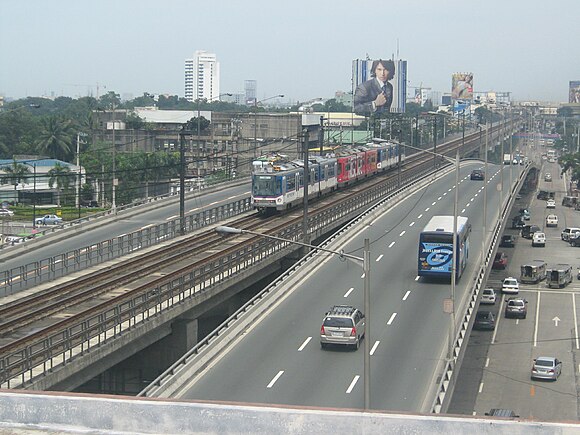
EDSA is a divided carriageway, often consisting of 12-lanes, 6 for both direction, with the elevated railroad Manila Metro Rail Transit System often serving as its median. EDSA is not an expressway, but traffic rules and speed limits are strictly implemented to the vehicles that pass along it. It is operated by the Metro Manila Development Authority and is maintained and constantly being repaired by the Department of Public Works and Highways (Philippines)
Route description
EDSA starts from the Andres Bonifacio Monument (Monumento) Roundabout in Gracepark, Caloocan City, adjacent to the Apolonio Samson Road, the western side of the C-4 Road. The roundabout is also the marker of the 1896 Revolution by Andres Bonifacio. The 1.7 kilometers of the road are in Caloocan City. The Avenue will then enter Quezon City through the Balintawak District, after an intersection with the North Luzon Expressway in the Balintawak Cloverleaf Interchange.

EDSA crosses much of the northern part of Quezon City, passing through the Project 6 and Munoz districts. It sharply curves southwards after crossing the North Avenue-West Avenue Intersection in the Triangle Business Park. On the north side of EDSA is the SM North EDSA, the biggest mall in the Philippines. In front of it is the TriNoma mall and the Eton Centris or Centris Walk. EDSA continues southwards, slightly turning westwards slowly until it leaves the Triangle Park after crossing the East Avenue-Timog Avenue Intersection, where the GMA-7 building is located. It continues through the district of Cubao, entering the Araneta Center after crossing the Aurora Boulevard Tunnel. In Cubao, several malls, infrastructure and offices are located, most notably the Smart Araneta Coliseum, the biggest coliseum in Southeast Asia. The Avenue curves southwards and enters the Santolan and Socorro districts, where the twin military bases of Camp Rafael Crame and Camp Aguinaldo, are located. The Greenhills Shopping Center and the Eastwood City are also located nearby. EDSA then continues on its route and serves as the boundary of the cities of San Juan and Quezon City. The People Power Monument can be seen on the north side of EDSA in the White Plains Avenue junction. After the 11 kilometers of EDSA in Quezon City, the Avenue will eventually leave the city and enter the City of Mandaluyong. EDSA enters Mandaluyong after crossing the borders of the Ortigas Center. In the Ortigas Center, some notable buildings around the area are the Philippine Overseas Employment Administration building, Robinson's Galleria, SM Megamall, Forum Robinsons (Robinson's Pioneer), and the bronze EDSA Shrine, a memorial monument for the 1986 Revolution. It then curves smoothly westwards after it crosses the Pioneer Street, and crosses the Pasig River via the Guadalupe Bridge and leaving the City of Mandaluyong.
It enters the city of Makati after crossing the Pasig River, passing through the districts of Guadalupe, Comembo and Magallanes. In Guadalupe, EDSA provides access to the Rockwell Center, a major mixed-use business park in Makati. The highway also provides quick access to the city of Taguig and the Bonifacio Global City nearby. After crossing Buendia Avenue, the highway enters the Ayala Center, an important industrial district in the Philippines, where the Greenbelt and Glorietta shopping centers are located. The road then curves eastwards and continues on a straight route to the city of Pasay.
EDSA enters Pasay shortly after crossing the South Luzon Expressway in Makati. In Pasay, the highway provides access to the Ninoy Aquino International Airport via a flyover. EDSA enters the Baclaran Shopping Center and continues eastward until it enters the Bay City reclamation area, where the large SM Mall of Asia is located. EDSA's terminus is at a rotunda in front of the Globe of the SM Mall of Asia.
Traffic management
The lead agency that manages the flow of traffic along EDSA is the Metropolitan Manila Development Authority (MMDA), an agency that is under the Office of the President and is advised by the Metro Manila Mayors League. One of the MMDA's traffic management schemes that is in effect on EDSA, among other major thoroughfares in the metropolis, is the Uniform Vehicular Volume Reduction Program.
Many have observed that the cause of many traffic jams on EDSA are erring buses and jeepneys. Subsequently, buses have been the target of other traffic management programs, like the MMDA's Organized Bus Route Program.[4] The MMDA is strictly implementing also the Motorcycle and Bus laning in EDSA, making it the second freeway in the Philippines ever to have such traffic rule to be enforced, after Commonwealth Avenue.[5] [3] The average speed of vehicles in EDSA is 15 kilometres per hour (9.3 mph).
History
Construction of what was then called the "North-South Circumferential Road" started in the 1930s, during the term of the President Manuel L. Quezon, with the construction team led by engineers Florencio Moreno and Osmundo Monsod.[6][1]
The road, starting from the North Diversion Road (today the North Luzon Expressway) and ending at the current Magallanes Interchange with the South Luzon Expressway, was finished in 1940, shortly before World War II and the subsequent Japanese occupation of the Philippines. After the independence of the Philippines in 1946, the road was renamed Avenida 19 de Junio (June 19 Avenue), after the birthdate of national hero José Rizal.[1][6]
In the 1950s, the avenue had been renamed Highway 54, because of the common misconception on that time that the avenue is 54 km long.[1] Rizalists wanted the avenue's name to be kept as 19 de Junio, while President Ramon Magsaysay wanted the avenue be named after Rizal. Rizal Province residents, however, wanted the avenue to be named after a Rizaleño, a historian, jurist and scholar named Epifanio de los Santos y Cristóbal. The Philippine Historical Committee (now the National Historical Commission of the Philippines), the Philippine Historical Association, the Philippine Library Association, Association of University and College Professors, the Philippine China Cultural Association, and the Philippine National Historical Society, led by fellow Rizaleños Eulogio Rodriguez Sr. and Juan Sumulong, supported the renaming of Highway 54 to Epifanio de los Santos Avenue.
On April 7, 1959, de los Santos' birthday, Republic Act No. 2140 was passed, renaming the avenue to honor him.[7] Rapid urbanization in the 1960s and 1970s, particularly during the annexation of several Rizal towns to the newly-formed National Capital Region, marked the growth of the industrial centers along the road, and several other roads connected to the avenue, such as Ayala Avenue and the McKinley Road in Makati.
During the tenure of President Ferdinand Marcos, traffic jams in the avenue started to build up. Several interchanges were constructed to relieve congestion, including the Balintawak Cloverleaf and the Magallanes Interchange at the ends of the avenue. Later, with the implementation of the Metro Manila Arterial Road System in 1965, in order to complete the Circumferential Road 4 system, EDSA was extended to Taft Avenue from the South Luzon Expressway (the extension was called F. Rein Avenue), and further to Roxas Boulevard (the extension was called P. Lovina Avenue). EDSA was also extended from its original Balintawak terminus to the Apolonio Samson Road at the site of the Bonifacio Monument in Caloocan, completing the Circumferential Road 4 system.
The EDSA Revolution


In 1986, Ferdinand Marcos's political opponents revolted against his 20-year dictatorial government, seizing the Camp Rafael Crame and Camp Aguinaldo military bases, both located along EDSA. On February 25, 1986, Epifanio de los Santos Avenue gained worldwide attention as the site of the peaceful People Power Revolution that toppled President Marcos, led by Corazon Aquino. The majority of the demonstrations took place on a long stretch of the avenue, involving over two million Filipino civilians as well as several political, military, and religious groups led by Cardinal Jaime Sin, the Archbishop of Manila.
Recent history
After the People Power Revolution, the avenue had been commonly known as EDSA, and the southern extensions were merged into the avenue. In 1997, the Manila Metro Rail Transit System began construction, being built over EDSA from North Avenue to Taft Avenue during the presidency of Joseph Estrada.[8][9]
In 2006, the avenue was further extended from Roxas Boulevard to the SM Mall of Asia, where it now ends at the Mall of Asia Globe and roundabout. Also, in 2006, the avenue was badly damaged in September, when Typhoon Milenyo hit Manila. EDSA became the site and main route of the funeral procession of the former-President Corazon Aquino, who died in 2009.[10]
In 2010, the Yellow Line of the Manila Light Rail Transit System was extended from Monumento to Roosevelt, ultimately transversing EDSA to end at the site of the current North Avenue MRT Station.
In August 2012, prior to the Congressional hearing of a controversial reproductive health bill proposal, the Catholic Church assembled a mass rally on EDSA to show opposition to the proposal.[11]
Exits and major intersections
| Epifanio De los Santos Avenue (C-4) | |||||
| mile | km | Northbound exits (B carriageway) | Junction | Southbound exits (A carriageway) | |
|---|---|---|---|---|---|
| 0.0 | 0.0 | Gracepark, Caloocan City, Valenzuela City AH-26 | MacArthur Highway (North R-9) and Rizal Avenue (South R-9) [coord 1] |
Binondo District of the City of Manila | |
| 1 mi | 1.7 km | Valenzuela City, Quezon City, North Luzon Expressway R-8 A | A. Bonifacio Street (R-8) and North Luzon Expressway R-8 A | Divisoria District of the City of Manila, A. Bonifacio Street R-8 | |
| 1 mi | 1.7 km | Novaliches District of Quezon City, City of San Jose del Monte in Bulacan | Quirino Highway R-8 B | Divisoria District of the City of Manila, A. Bonifacio Street R-8 | |
| 2 mi | 2.9 km | Tandang Sora area of Quezon City, Kaingin Road | Kaingin Road and Honnart Road | Gregorio Araneta Avenue C-3, La Loma and Roxas Districts of Quezon City | |
| 2 mi | 3.8 km | Munoz and Tandang Sora Districts of Quezon City | Roosevelt Avenue (South) and Congressional Avenue (North) | Pantranco and Tatalon Districts of Quezon City | |
| 2 mi | 5 km | SM City North EDSA, Tri No Ma Malls, North Triangle of the Triangle Park | North Avenue (North) and West Avenue (South) [coord 2] |
San Francisco Del Monte District of Quezon City | |
| 3 mi | 5.7 km | Northern Circumferential Road 5 C-5 | Mindanao Avenue (North) | ||
| 4 mi | 6.5 km | Quezon Memorial Circle, Commonwealth Avenue, Commonwealth and Batasan Districts of Quezon City | Quezon Avenue R-7 | Mabuhay Rotunda, Espana Boulevard, Sampaloc and Quiapo Districts of the City of Manila | |
| Kamuning Flyover starts | |||||
| 4 mi | 7.9 km | East Avenue Medical Center, East Triangle of the Triangle Park, Central Bank of the Philippines | East Avenue (South) and South Avenue (North) | GMA Network Studio, South Triangle of the Triangle Park | |
| 5 mi | 8.8 km | Kamuning District of Quezon City | Kamuning Avenue (North), Kamias Road (South) | New Manila District of Quezon City | |
| Kamuning Flyover ends | |||||
| 1 mi | 6 km | Araneta Center and Cubao Districts of Quezon City, Marikina City, Antipolo City and Taytay City in Rizal Province (Via Marcos Highway) | Aurora Boulevard R-6 [coord 3] | Sta. Mesa District of the City of Manila, Polytechnic University of the Philippines | |
| 6 mi | 9.9 km | Araneta Center, Circumferential Road 5 | Pedro Tuazon Boulevard (The underpass is yet under renovation) | New Manila District | |
| 7 mi | 10.6 km | Circumferential Road 5 C-5, Camp Aguinaldo Headquarters, Eastwood City | Santolan Road (South) and Col. Bonny Serrano Avenue (North) | Santolan District of Quezon City | |
| 7 mi | 11.7 km | No access | Annapolis Road (South) | Greenhills Shopping Center in San Juan City | |
| 8 mi | 11.9 km | Katipunan Avenue | White Plains Avenue (North) | No access | |
| 9 mi | 12.7 km | Ortigas Center, Taytay in the Rizal Province | Ortigas Avenue [coord 4] | Greenhills Shopping District | |
| 9 mi | 13.7 km | No access, should have been leading to SM Megamall | Donya Julia Vargas Avenue (North) [coord 5] | No access | |
| 10 mi | 14.2 km | Ortigas Center, Taytay in the Rizal Province | Shaw Boulevard R-5 | Sta. Mesa and Paco Districts in the City of Manila | |
| 10 mi | 15.4 km | Ortigas Center | Boni Avenue (South) and Pioneer Road (North) | San Juan City, Robinson's Forum | |
| EDSA crosses the Pasig River via the Guadalupe Bridge | |||||
| 11 mi | 15.8 km | Guadalupe Viejo District of Makati City Circumferential Road 5 C-5 |
J.P. Rizal Street | Guadalupe Nuevo District Rockwell Center | |
| 1.8 mi | 17.3 km | Estrella Street (Southbound) | Rockwell Center | ||
| Kalayaan Flyover from SB EDSA elevates, leading to the 32th Street | |||||
| Kalayaan Flyover from Buendia Avenue elevates, leading to the 32th Street | |||||
| 11 mi | 17.4-17.8 km | Sta. Ana District of the City of Manila | Kalayaan Avenue R-4 | Bonifacio Global City Circumferential Road 5 C-5 Rizal Province | |
| Buendia Avenue (Senator Gil Puyat Avenue) (Southbound) | Circumferential Road 3 C-3 | ||||
| Ayala Underpass starts | |||||
| 12 mi | 18.4-19.1 km | Ayala Center Circumferential Road 3 C-3 |
Ayala Avenue (Southbound) and McKinley Road (Northbound) | Bonifacio Global City Manila International Airport | |
| Antonio S. Arnaiz Avenue (Pasay-Libertad Road) | SM Makati Ayala Center | ||||
| 12 mi | 20.4 km | Lawton Avenue Bonifacio Global City |
Pasong Tamo (Chino Roces Avenue) | Ayala Center Sta. Ana District of the City of Manila | |
| Alabang Town Center Provinces of Laguna and Cavite |
South Luzon Expressway R-3 | Paco District of the City of Manila Magallanes District of Makati City | |||
| 2.2 mi | 21.8 km | Manila International Airport | Aurora Boulevard (Tramo Line) (Northbound) | Manila International Airport (via a flyover) | |
| 12 mi | 22.8 km | Province of Cavite Baclaran District of Pasay City |
Taft Avenue R-2 | Ermita and Malate Districts of the City of Manila (no access from Northbound) | |
| 12 mi | 22.9 km | Province of Cavite Baclaran District of Pasay City |
F.B. Harrison (Southbound) and Quirino Avenue (Northbound) AH-26 | Ermita and Malate Districts of the City of Manila | |
| 12 mi | 23 km | Coastal Road Province of Cavite Baclaran District of Pasay City |
Roxas Boulevard R-1 | Luneta, Ermita and Malate Districts of the City of Manila | |
| 13 mi | 23.4 km | Bay City, Metro Manila | Diosdado Macapagal Boulevard | Province of Cavite via Coastal Road | |
| 14.8 mi | 24 km | J.W. Diokno Boulevard SM Mall of Asia |
Globe Rotunda | J.W. Diokno Boulevard SM Mall of Asia | |
| 1.000 mi = 1.609 km; 1.000 km = 0.621 mi | |||||
Future Developments
Proposed Interchanges
An overpass over the North Avenue-West Avenue Intersection and Mindanao Avenue Junction in the Triangle Park and a Flyover over Congressional Avenue and Roosevelt Avenue Intersection in Munoz are already approved, and may start construction in 2013.[12]
Proposed renaming
In 2011, Bohol Representative Rene Lopez Relampagos filed House Bill (HB) No. 5422, proposing to rename Epifanio de los Santos Avenue as "Corazon Aquino Avenue." The proposal is currently pending in the Philippine House of Representatives before the House Committee on Public Works and Highways. According to Relampagos, the idea to rename EDSA after Aquino (who led the 1986 People Power) was conceptualized in the aftermath of her death.
In Popular culture
EDSA is featured in the film The Bourne Legacy. Portions of the road from Magallanes Interchange to Taft Avenue were featured in a car chase wherein Aaron Cross, played by Jeremy Renner, jumps from the Taft Avenue footbridge to a plying bus.[13][14] Also, every February 25, the day of the EDSA People Power Revolution, the statues in the People Power Monument in the White Plains junction were repainted and yellow flags were placed on their hands, in order to commemorate the successful revolution.[15]
EDSA is also continuously being used in political campaigns by several politicians, particularly those who had been involved in the EDSA Revolution such as Joseph Estrada and Benigno Aquino III.
Gallery
-
EDSA-Aurora Underpass
-
MRT-LRT Connecting Bridge(Pasay Rotonda(EDSA - Taft Ave.))
-
EDSA Shaw overpass
-
EDSA Muñoz
-
Southern end of EDSA in the SM Mall of Asia
-
EDSA corner West Avenue and North Avenue Quezon City


See also
- Metro Manila
- Major roads in Metro Manila
- MacArthur Highway
- Quirino Highway
- South Luzon Expressway
- North Luzon Expressway
- C-3 Road
- C-5 Road
- Manila Metro Rail Transit System
References
- ^ a b c d e Peter Uckung (February 22, 2012). "History in Asphalt (Epifanio de los Santos Avenue (Edsa) is the longest road in Metro Manila. Peter Uckung, senior researcher at the National Historical Commission of the Philippines (NHCP), explains how this thoroughfare came to be.)". Business world Online.
{{cite web}}: Unknown parameter|Access date=ignored (help) - ^ Philippine Daily Inquirer (July 7, 2009). "Inquirer Headlines: EDSA". Philippine Daily Inquirer. Retrieved July 9, 2012.
- ^ a b Jao-Grey, Margarte (December 27, 2007). "Too Many Buses, Too Many Agencies Clog Edsa". Philippine Center for Investigative Journalism. Retrieved December 28, 2007.
- ^ MMDA Resolution No. 03-28
- ^ MMDA Resolution No. 04-01
- ^ a b "Epifanio De los Santos Avenue". Wikipilipinas.org. Retrieved December 15, 2012.
- ^ Chan Robles Virtual Law Library - REPUBLIC ACT NO. 2140 - AN ACT CHANGING THE NAME OF HIGHWAY 54 IN THE PROVINCE OF RIZAL TO EPIFANIO DE LOS SANTOS AVENUE IN HONOR OF DON EPIFANIO DE LOS SANTOS, A FILIPINO SCHOLAR, JURIST AND HISTORIAN
- ^ GMA Launches transit system, Philippine Star, July 15, 2003
- ^ NUMBER OF MOTOR VEHICLES REGISTERED: Comparative, JAN.- DEC. 2003, 2004, 2005, Land Transportation Office, January 23, 2006
- ^ M. Meruenias and A. Calonzo (August 1, 2009). "No state funeral for Aquino". GMANEWS.TV. Retrieved December 15, 2012.
- ^ ABS-CBN (August 3, 2012). "Church eyes red revolution vs RH Bill". Retrieved August 20, 2012.
- ^ "DPWH Future PP Projects" (PDF). Department of Public Works and Highways (Philippines). Retrieved December 15, 2012.
- ^ "'Bourne Legacy' shoot at EDSA-Taft then Palawan". Retrieved August 25, 2012.
- ^ GMA News Online (January 27, 2012). "'Bourne Legacy' to shoot on EDSA in Pasay, some roads closed". GMA News. Retrieved August 25, 2012.
- ^ "iReport EDSA 20th Anniversary Special Issue | Dr. William Castro". Philippine Center for Investigative Journalism, February 2006. Retrieved 2008-01-16.
- Coordinate list
- ^ 14°39′14.74″N 120°59′02.06″E / 14.6540944°N 120.9839056°E Andres Bonifacio Monument Roundabout
- ^ 14°39′25″N 121°01′50″E / 14.6570269°N 121.0304815°E SM City North EDSA
- ^ 14°37′15″N 121°03′12″E / 14.6207°N 121.0532°E Araneta Center
- ^ 14°35′00″N 121°03′40″E / 14.58333°N 121.06111°E EDSA-Corithian
- ^ 14°35′04.01″N 121°03′24.38″E / 14.5844472°N 121.0567722°E SM Megamall
Template:Major Roads in the Phillipines
| Historical sites |  | |
|---|---|---|
| Religious buildings | ||
| Museums and galleries |
| |
| Integrated resorts | ||
| Amusement |
| |
| Parks and gardens | ||
| Shopping | ||
| Events and traditions | ||
| Event venues | ||
| By type | ||