Jesús de Otoro
Jesús de Otoro | |
|---|---|
Municipality | |
 Jesús de Otoro Location of Jesús de Otoro in Honduras | |
| Coordinates: 14°29′7.37″N 87°58′45.76″W / 14.4853806°N 87.9793778°W | |
| Country | |
| Government | |
| • Mayor of Jesús de Otoro | Roger Cantarero |
| Area | |
| • Total | 419 km2 (162 sq mi) |
| Elevation | 1,700 m (5,600 ft) |
| Population (2023 projection)[1] | |
| • Total | 34,052 |
| • Density | 81/km2 (210/sq mi) |
| Time zone | UTC-6 (Central America) |
| Postal code | 14201 |
| Municipality number | 1007 |
Jesús de Otoro is a town, with a population of 11,930 (2023 calculation),[2] and a municipality in the Honduran department of Intibucá.
Demographics
[edit]At the time of the 2013 Honduras census, Jesús de Otoro municipality had a population of 28,301. Of these, 84.35% were Mestizo, 12.97% Indigenous (12.68% Lenca), 2.37% White, 0.26% Black or Afro-Honduran and 0.05% others.[3]
Sport
[edit]Cobán Athletic, an association football club, is based in Jesús de Otoro.
References
[edit]- ^ Citypopulation.de Population of departments and municipalities in Honduras
- ^ Citypopulation.de Population of cities in Honduras
- ^ Instituto Nacional de Estadística (INE), bases de datos en línea
Capital: La Esperanza | ||
| Municipalities | 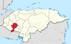 | |
| International | |
|---|---|
| National | |
This Honduras location article is a stub. You can help Wikipedia by expanding it. |