Kunar Province
Template:Geobox 35°00′N 71°12′E / 35.0°N 71.2°E
Kunar (Pashto: کونړ) is one of the 34 provinces of Afghanistan, located in the northeastern part of the country. Its capital is Asadabad. It is one of the four "N2KL" provinces (Nangarhar Province, Nuristan Province, Kunar Province and Laghman Province). N2KL is the designation used by US and Coalition Forces in Afghanistan for the rugged and very violent region along the Afghanistan-Pakistan border opposite Pakistan's Federally Administered Tribal Areas and North-West Frontier Province. Kunar is the center of the N2KL region.
Geography
Kunar province is located in the northeast of Afghanistan. It borders with Nangarhar Province to the south, Nuristan Province to the north, Laghman Province to the west and has a border with Pakistan in the east. The province covers an area of 4339 km2. Nearly nine tenths (86%) of the province is mountainous or semi mountainous terrain while one eighth (12%) of the area is made up of relatively flat land. The primary geographic features of the province are (1) the lower Hindu Kush mountains which form, (2) the Kunar Valley, and (3) the Kunar River which flows south along the north-south axis of the valley is a primary draining conduit for the Hindu Kush basin. The mountains, narrow valleys with steeps sides and river serve as formidable natural obstacles and have impacted all movement through the province throughout history. Even in the early 21st century movement on foot, with pack animals or with motorized vehicles is extremely limited and channeled due to the significant geographic restrictions. One famous Pashtun poet, Mohammad Hashem Zamani, was from Kunar.
Demographics & population
The total population of Kunar was estimated to be around 413,008 (CSO Afghanistan, 2006).[1] Pashtuns are in majority and make up 95% of the total population, followed by Nuristanis and Tajiks.[2]
Around 96% of the population of Kunar lives in rural districts while 4% lives in urban areas.[1]
Military activity

During the 19th century British military expeditions, the 20th century Soviet occupation, and the 21st century conflicts involving U.S., Afghan and NATO forces, Kunar has been a favoured spot of insurgent groups. Its impenetrable terrain, cave networks and border with the semi-autonomous Pakistani North-West Frontier Province provides significant advantages for unconventional warfare and militant groups. The province is informally known as "Enemy Central" and "Indian Country" by American and western armed forces serving in Afghanistan. Between January 2006 and March 2010 more than 65% of all insurgent incidents in the country occurred in Kunar.
Like many of the mountainous eastern provinces of Afghanistan, the groups involved in armed conflict vary greatly in strength and purpose. Native Taliban forces mingle with foreign Al-Qaeda fighters, while mujahadeen militias, such as Gulbuddin Hekmatyar's Hezb-e-Islami Gulbuddin, continue to operate as they did in the chaotic post-Soviet years. Another strong militia in the region is the Hezbi Islami faction of the late Mulavi Younas Khalis, who had his headquarters in neighbouring Nurestan Province.

Compounding the problems of the province is an extensive criminal trade in smuggled lumber, semi-precious stones and other natural resources. This criminal activity is often organized along tribal lines, and has led to intense deforestation in some areas. The rugged border area has many illegal and hidden crossing points making Kunar a high traffic route for illegal arms transporting, insurgent movement and other smuggling activities.
The province, relatively small compared to others, has among the highest concentration of both US and Afghan security forces. Special Operations Forces operate extensively throughout the area.
As of September 2011 the United States has awarded six Medals of Honor for action in Afghanistan. Five of these have been awarded for separate actions in Kunar province.[citation needed] Members of I Corps Artillery (deactivated and is now 65th Fires Brigade) of the Utah National Guard served as Embedded Tactical Trainers (ETTs) while embedded with the Afghan National Army and U.S. Army's 10th Mountain Division throughout Kunar Province.[citation needed] The 1-14th Agriculture Development Team from the Illinois Army National Guard began working in Kunar in June 2011. ADTs from the California and Iowa National Guard have previously served in the province.[citation needed]
Searches for bin Laden
Osama bin Laden had often been rumoured to be in the province, or close by. In an intensive military operation in summer 2005, called Operation Red Wing, American forces undertook a massive hunt for bin Laden and other senior Al-Qaeda leaders. While attempting to rescue four stranded Navy SEALs during the operation, 19 American Forces were killed when their CH-47 Chinook helicopter was shot down, representing the second biggest loss of American forces since their invasion of the country.
According to Pakistan's Interior Minister Rehman Malik, Osama bin Laden was most likely hiding in Kunar Province in the spring and summer of 2009: "According to our information Osama is in Afghanistan, probably Kunar, as most of the activities against Pakistan are being directed from Kunar.”[3]
Until Bin Laden was later found and killed in Abbottabad, Pakistan contrary to what the Pakistani government had previously stated.
Politics
Fazlullah Wahidi replaced Assadullah Wafa as the governor of Kunar Province on November 18, 2007.
Reconstruction and international assistance
Asadabad hosts both an American Provincial Reconstruction Team at nearby Forward Operating Base Wright and a UNAMA development office. Additionally, representatives of the United States Agency for International Development (USAID), US State and Agriculture Departments advise the local government. A US Army Agribusiness Development Team (ADT) was deployed to the province in late 2009. Successive ADTs continue to serve in the province.[citation needed]
In media
The 2010 documentary Restrepo was filmed in the Korengal Valley of Kunar Province.
The story told in the book Lone Survivor took place in the Korengal Valley of Kunar Province.
Districts
The districts in Kunar Province as of March 2004 are:[4]
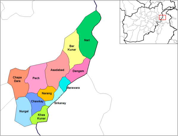

| District | Capital | Pop.[1] | Area[5] | Notes |
|---|---|---|---|---|
| Asadabad | 29,177 | Is the Capital of Kunar Province, which includes Asadabad and adjacent towns, immediately surrounding the confluence of the Pech and Kunar Rivers. | ||
| Bar Kunar | 20,716 | |||
| Chapa Dara | 28,681 | |||
| Dangam | 15,509 | |||
| Dara-I-Pech | 44,958 | Commonly known as the Pech District or Manogai District. | ||
| Ghaziabad | Ghaziabad | 7,500 | formerly northern Bar Kunar District | |
| Khas Kunar | 31,950 | |||
| Marawara | 17,316 | |||
| Narang | 27,937 | |||
| Nari | 32,510 | |||
| Nurgol | 25,047 | |||
| Sawkai | 28,905 | |||
| Shigal | 33,781 | formed from northeastern Dangam District | ||
| Sirkani | 24,080 | |||
| Wata Pur | 28,778 | formed from northwestern Asadabad District |
See also
References
- ^ a b c Cite error: The named reference
mrrdwas invoked but never defined (see the help page). - ^ Afghanistan's Provinces– Kunar at NPS
- ^ Christina Lamb, "Stop bombing us: Osama isn’t here, says Pakistan" The Sunday Times, July 12, 2009
- ^ "Afghanistan Administrative Divisions" map, March 2007, Afghanistan Information Management Services (AIMS)
- ^ Afghanistan Geographic & Thematic Layers
Places adjacent to Kunar Province | |
|---|---|