Karmravank (Vaspurakan)
| Karmravank Կարմրավանք | |
|---|---|
 Karmravank in Summer 2006 | |
| Religion | |
| Affiliation | Armenian Apostolic Church |
| Status | abandoned |
| Location | |
| Location | southern shore of Lake Van |
 Shown within Turkey | |
| Geographic coordinates | 38°22′20″N 42°54′15″E / 38.372315°N 42.904281°E |
| Architecture | |
| Style | Armenian |
| Groundbreaking | tenth century |
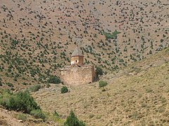
Karmravank (Armenian: Կարմրավանք, meaning Red Monastery) is an abandoned 10th century Armenian monastery in the Vaspurakan province of historic Armenia[1] (now in the Van Province of Turkey). It was founded by King Gagik I (908-943) of the Artsruni dynasty.[1] It is located 12 kilometers west-northwest of Akhtamar Island.
Gallery
[edit]-
Karmravank in its natural setting
-
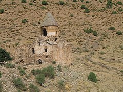
View of the church from the south
-
View of the church from the south-west
-
View of church from the west
-
Closeup of the damaged dome
-
An Armenian khachkar reused as a lintel
-
Upper level doorway leading to the north-west gallery
-
Drum of the church and its supporting vaults
-
View of dome from the inside
-
The apse of the church
-
View of Lake Van and Mount Artos seen from the monastery


See also
[edit]- Narekavank, a nearby 10th century Armenian monastery also founded by King Gagik
- Akhtamar Island, a nearby island on Lake Van with the 10th century Armenian Church of the Holy Cross
References
[edit]- ^ a b Hewsen, Robert H. (2000), "Van in This World; Paradise in the Next: The Historical Geography of Van/Vaspurakan", in Hovannisian, Richard G. (ed.), Armenian Van/Vaspurakan, Historic Armenian Cities and Provinces, Costa Mesa, California: Mazda Publishers, p. 27, OCLC 44774992
External links
[edit]Wikimedia Commons has media related to Karmravank (Vaspurakan).


