Sutton Creek (Ireland): Difference between revisions
Content deleted Content added
info |
No edit summary |
||
| Line 18: | Line 18: | ||
| location = [[Dublin, Ireland]] |
| location = [[Dublin, Ireland]] |
||
| group = |
| group = |
||
| coordinates = {{coord|53| |
| coordinates = {{coord|53|22|55|N|6|06|30|W|display=title|region:IE_type:waterbody}} |
||
| type = |
| type = |
||
| etymology = |
| etymology = |
||
| Line 62: | Line 62: | ||
}} |
}} |
||
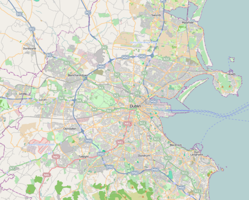
'''Sutton Creek''' is part of [[Dublin Bay]] that lies between the southwestern part of [[Howth Head]] and the northeast end of [[Bull Island]]. It forms the southern coastline of [[Sutton, Dublin|Sutton]] and is bounded by Dublin Road, Greenfield Road and Strand Road. |
'''Sutton Creek''' is part of [[Dublin Bay]] that lies between the southwestern part of [[Howth Head]] and the northeast end of [[Bull Island]]. It forms the southern coastline of [[Sutton, Dublin|Sutton]] and is bounded by Dublin Road, Greenfield Road and Strand Road. |
||
{{coord|53|22|55|N|6|06|30|W|display=title|region:IE_type:waterbody}} |
|||
[[Category:Sutton, Dublin]] |
[[Category:Sutton, Dublin]] |
||
{{Dublin-geo-stub}} |
{{Dublin-geo-stub}} |
||
Revision as of 21:11, 19 April 2022
| Sutton Creek | |
|---|---|
 View to south | |
 Sutton Creek | |
| Location | Dublin, Ireland |
| Coordinates | 53°22′55″N 6°06′30″W / 53.38194°N 6.10833°W |
| Part of | Irish Sea |
| Settlements | Sutton, Dublin |
Sutton Creek is part of Dublin Bay that lies between the southwestern part of Howth Head and the northeast end of Bull Island. It forms the southern coastline of Sutton and is bounded by Dublin Road, Greenfield Road and Strand Road.
This geographical article about the Dublin area is a stub. You can help Wikipedia by expanding it. |