Temryuk: Difference between revisions
No edit summary |
m remove Erik9bot category,outdated, tag and general fixes |
||
| Line 1: | Line 1: | ||
{{Unreferenced stub|auto=yes|date=December 2009}} |
|||
[[Image:Coat of Arms of Temryuk (Krasnodar krai).png|thumb|130px|Coat of arms of Temryuk]] |
[[Image:Coat of Arms of Temryuk (Krasnodar krai).png|thumb|130px|Coat of arms of Temryuk]] |
||
'''Temryuk''' ({{ |
'''Temryuk''' ({{Lang-ru|Темрю́к}}) is the largest [[types of settlements in Russia|town]] on the [[Taman peninsula]] in [[Krasnodar Krai]], [[Russia]], located on the right bank of the [[Kuban River]] not far from its entry into the [[Temryuk Bay]], amid a field of [[mud volcano]]es. The [[seaport]] of Temryuk is situated four kilometers away from the town itself. Population: 36,118 ([[Russian Census (2002)|2002 Census]]); 26,600 (1975). |
||
Situated in the proximity of the site of ancient [[Tmutarakan]], Temryuk was vied by various powers as a vantage point commanding the mouth of the Kuban River. The first recorded settlement on the site was '''Tumnev''', a Tatar fortress, which passed to the [[Ghisolfi|Genoese merchants]] in the 14th century. It was known as '''Copa''' until occupied by the [[Khanate of Crimea]] in 1483. |
Situated in the proximity of the site of ancient [[Tmutarakan]], Temryuk was vied by various powers as a vantage point commanding the mouth of the Kuban River. The first recorded settlement on the site was '''Tumnev''', a Tatar fortress, which passed to the [[Ghisolfi|Genoese merchants]] in the 14th century. It was known as '''Copa''' until occupied by the [[Khanate of Crimea]] in 1483. |
||
| Line 9: | Line 10: | ||
---- |
---- |
||
{{ |
{{Commons category|Temryuk}} |
||
<gallery> |
<gallery> |
||
File:Трактир в музее.JPG|<small>[[Voennaya Gorka]], a military vehicle museum on the slope of a mud vulcano in Temryuk.<small/> |
File:Трактир в музее.JPG|<small>[[Voennaya Gorka]], a military vehicle museum on the slope of a mud vulcano in Temryuk.<small/> |
||
| Line 19: | Line 20: | ||
{{Cities and towns in Krasnodar Krai}} |
{{Cities and towns in Krasnodar Krai}} |
||
{{ |
{{Coord|45|16|N|37|23|E|type:city_region:RU|display=title}} |
||
[[Category:History of Kuban]] |
[[Category:History of Kuban]] |
||
[[Category:Articles lacking sources (Erik9bot)]] |
|||
{{KrasnodarKrai-geo-stub}} |
{{KrasnodarKrai-geo-stub}} |
||
| Line 33: | Line 34: | ||
[[fr:Temriouk]] |
[[fr:Temriouk]] |
||
[[it:Temrjuk]] |
[[it:Temrjuk]] |
||
| ⚫ | |||
[[no:Temrjuk]] |
[[no:Temrjuk]] |
||
[[nn:Temrjuk]] |
[[nn:Temrjuk]] |
||
| Line 41: | Line 43: | ||
[[uk:Темрюк]] |
[[uk:Темрюк]] |
||
[[zh:提姆留克]] |
[[zh:提姆留克]] |
||
| ⚫ | |||
Revision as of 15:19, 17 December 2009

Temryuk (Russian: Темрю́к) is the largest town on the Taman peninsula in Krasnodar Krai, Russia, located on the right bank of the Kuban River not far from its entry into the Temryuk Bay, amid a field of mud volcanoes. The seaport of Temryuk is situated four kilometers away from the town itself. Population: 36,118 (2002 Census); 26,600 (1975).
Situated in the proximity of the site of ancient Tmutarakan, Temryuk was vied by various powers as a vantage point commanding the mouth of the Kuban River. The first recorded settlement on the site was Tumnev, a Tatar fortress, which passed to the Genoese merchants in the 14th century. It was known as Copa until occupied by the Khanate of Crimea in 1483.
The Russians, allied with a local potentate, Temryuk of Kabarda, captured Tumnev and built a fortress of New Temryuk there. The Crimean Tatars retook the fort in 1570; it was known as Adis for a century to come. In the 18th century the site was settled by the Cossacks, whose stanitsa was incorporated as a town of Temryuk in 1860.
-
Voennaya Gorka, a military vehicle museum on the slope of a mud vulcano in Temryuk.
-
A memorial devoted to the Defense of Temryuk during World War II
-
A WWII motor gun boat on exhibit at Voennaya Gorka
-
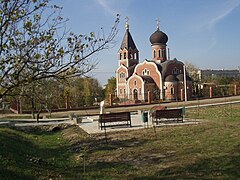
A local Orthodox church


45°16′N 37°23′E / 45.267°N 37.383°E
This Krasnodar Krai location article is a stub. You can help Wikipedia by expanding it. |