Tibetan Plateau
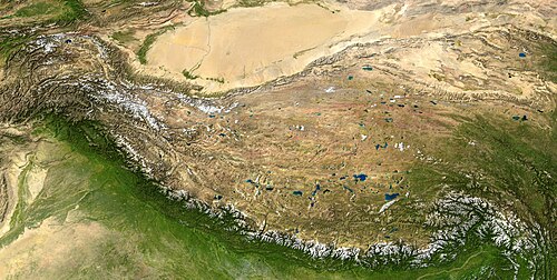
The Tibetan Plateau, also known as the Qinghai-Tibetan (Qingzang) Plateau is a vast, elevated plateau in East Asia covering most of the Tibet Autonomous Region and Qinghai Province in the People's Republic of China and Ladakh in Kashmir. It occupies an area of around 1,000 by 2,500 kilometers, and has an average elevation of over 4,500 meters. Called "the roof of the world," it is the highest and biggest plateau in the world, with an area of 2.5 million square kilometers (about four times the size of Texas or France).[1]
The Tibetan Plateau is surrounded by towering mountain ranges.[2] It is bordered to the northwest by the Kunlun Range which separates it from the Tarim Basin, and to the northeast by the Qilian Range which separates the plateau from the Gobi Desert. Near the south the plateau is transected by the Yarlung Tsangpo River valley which flows along the base of the Himalayas, and by the vast Indo-Gangetic Plain. To the east and southeast the plateau gives way to the forested gorge and ridge geography of the mountainous headwaters of the Salween, Mekong, and Yangtze rivers in western Sichuan and southwest Qinghai. In the west it is embraced by the curve of the rugged Karakoram range of northern Kashmir.
Description

The plateau is a high-altitude arid steppe interspersed with mountain ranges and large brackish lakes. Annual precipitation ranges from 100 mm to 300 mm and falls mainly as hailstorms. The southern and eastern edges of the steppe have grasslands which can sustainably support populations of nomadic herdsmen, although frost occurs for six months of the year. Proceeding to the north and northwest, the plateau becomes progressively higher, colder and drier, until reaching the remote Changtang region in the northwestern part of the plateau. Here the average altitude exceeds 20,000 meters (16,500 feet) and year-round temperatures average −4 °C, dipping to −40 °C in winter. As a result of this extremely inhospitable environment, the Changtang region (together with the adjoining Kekexili region) is the least populated region in Asia, and the third least populated area in the world after Antarctica and northern Greenland.[citation needed]
For extensive parts of the plateau, permafrost occurs.
Geology

The plateau was formed by the collision of the Indo-Australian and Eurasian tectonic plates near the beginning of the Cenozoic era (approximately 55 million years ago).[3] The tectonic uplift of the plateau is thought to have had a significant effect on climate change, and it is believed to affect the Asian monsoon. In the Indian monsoon season (June to October) when the winds bring humid, tropical air from the south, the Himalayas create a rain shadow which makes northern India very wet and keeps the Tibetan Plateau very dry. As the winds continue over the plateau, they drop what little moisture remains in the air, becoming drier as they move northwards and creating deserts such as the Taklamakan Desert and the Gobi Desert.[4]
Several of the world's longest rivers originate on the Tibetan Plateau. Between them, these rivers carry 25% of the world's soil erosion to the sea. These include the Yangtze River (known as Changjiang in China), Huang He (or Yellow River), Indus River, Satluj River, Yarlung Tsangpo River (known as the Brahmaputra in India), Mekong (known as Lancang Jiang in China), Salween River (known as the Nujiang in China) and the Irrawaddy River.
Its many brackish lakes include Tso Ngonpo (also known as Kokonor in Mongolian, and Qinghai Hu in Chinese), Nam Tso, Dagze Tso, Lake Yamzho Yumco, Lake Puma Yumco and Lake Paiku.
The Tibetan Plateau has experienced a number of glacial advances as indicated by glacial landforms and deposits.[5]
Nomads
One of the greatest advances in human culture is the development of nomadic pastoralism, the adaptation by nomadic people to survival on the world's grassland by raising livestock rather than crops which are unsuitable to the terrain. Nomads currently surviving on the Tibetan Plateau and in the Himalayas are the remainders of nomadic practices historically once widespread in Asia and Africa.[6]
Gallery

See also
References
- ^ "Natural World: Deserts". National Geographicc. Retrieved 2007-07-23.
- ^ "A Unique Geographical Unit". Retrieved 2007-08-05.
- ^ "The New Largest Canyon in the World --The Great Canyon of Yarlung Tsangpo River (Tibet)". Retrieved 2007-08-29.
{{cite web}}: Cite has empty unknown parameter:|month=(help) - ^ "Leaf morphology and the timing of the rise of the Tibetan Plateau". Retrieved 2007-07-23.
- ^ "Lehmkuhl and Owen (2005)". Boreas. Retrieved 2007-12-16.
- ^ David Miller. "Nomads of Tibet and Bhutan". asinart.com. Retrieved 2008-02-10.
Notes
- The End of Earth's Summer
- Long Rivers and Distant Sources
- "Roof of the Earth" Offers Clues About How Our Planet Was Shaped
External links
- Plateau Perspectives (international NGO)
- Leaf morphology and the timing of the rise of the Tibetan Plateau
- Todays weather in the eastern Chang Tang
- Protected areas of the Tibetan Plateau region
- North Tibetan Plateau-Kunlun Mountains alpine desert
- Photos of Tibetan nomads
- "Roof of the Earth" Offers Clues About How Our Planet Was Shaped
| Branches |
| ||||||||
|---|---|---|---|---|---|---|---|---|---|
| Techniques and tools |
| ||||||||
| Institutions | |||||||||
| Education | |||||||||