[go: nahoru, domu]

Jump to content

File:Crudgington station, 1983 geograph-3092306-by-Ben-Brooksbank.jpg

Page contents not supported in other languages.
This is a file from the Wikimedia Commons
From Wikipedia, the free encyclopedia

Original file(897 × 443 pixels, file size: 360 KB, MIME type: image/jpeg)

Summary

Description
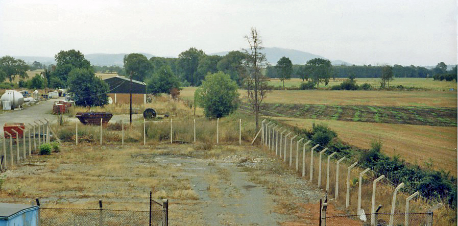
English: Site of Crudgington station, 1983.
View southwards, towards Wellington: ex-GWR Wellington - Market Drayton - Nantwich (- Crewe) line. All gone by 1983, the station and line had been closed from 9/9/63, but the railway was relatively important for through freight and was not closed until 1/5/67. The view is from the B5062 bridge and the Wrekin (1,335 ft.), a prominent hill in the region, is visible ahead.
Date
Source From geograph.org.uk
Author Ben Brooksbank
Permission
(Reusing this file)
Creative Commons Attribution Share-alike license 2.0
Attribution
(required by the license)
InfoField
Ben Brooksbank / Site of Crudgington station, 1983 / 
Ben Brooksbank / Site of Crudgington station, 1983
Camera location52° 45′ 28.65″ N, 2° 33′ 09.57″ W  Heading=157° Kartographer map based on OpenStreetMap.View this and other nearby images on: OpenStreetMapinfo

Licensing

w:en:Creative Commons
attribution share alike
This file is licensed under the Creative Commons Attribution-Share Alike 2.0 Generic license.
Attribution: Ben Brooksbank
You are free:
  • to share – to copy, distribute and transmit the work
  • to remix – to adapt the work
Under the following conditions:
  • attribution – You must give appropriate credit, provide a link to the license, and indicate if changes were made. You may do so in any reasonable manner, but not in any way that suggests the licensor endorses you or your use.
  • share alike – If you remix, transform, or build upon the material, you must distribute your contributions under the same or compatible license as the original.

Captions

Add a one-line explanation of what this file represents

Items portrayed in this file

depicts

copyrighted<\/a>"}},"text\/plain":{"en":{"P6216":"copyrighted"}}}}" class="wbmi-entityview-statementsGroup wbmi-entityview-statementsGroup-P6216 oo-ui-layout oo-ui-panelLayout oo-ui-panelLayout-framed">
Creative Commons Attribution-ShareAlike 2.0 Generic<\/a>"}},"text\/plain":{"en":{"P275":"Creative Commons Attribution-ShareAlike 2.0 Generic"}}}}" class="wbmi-entityview-statementsGroup wbmi-entityview-statementsGroup-P275 oo-ui-layout oo-ui-panelLayout oo-ui-panelLayout-framed">
file available on the internet<\/a>"}},"text\/plain":{"en":{"P7482":"file available on the internet"}}},"{\"value\":{\"entity-type\":\"property\",\"numeric-id\":137,\"id\":\"P137\"},\"type\":\"wikibase-entityid\"}":{"text\/html":{"en":{"":"operator<\/a>"}},"text\/plain":{"en":{"":"operator"}}},"{\"value\":{\"entity-type\":\"item\",\"numeric-id\":1503119,\"id\":\"Q1503119\"},\"type\":\"wikibase-entityid\"}":{"text\/html":{"en":{"P137":"Geograph Britain and Ireland<\/a>"}},"text\/plain":{"en":{"P137":"Geograph Britain and Ireland"}}},"{\"value\":{\"entity-type\":\"property\",\"numeric-id\":7384,\"id\":\"P7384\"},\"type\":\"wikibase-entityid\"}":{"text\/html":{"en":{"":"geograph.org.uk image ID<\/a>"}},"text\/plain":{"en":{"":"geograph.org.uk image ID"}}},"{\"value\":\"3092306\",\"type\":\"string\"}":{"text\/html":{"en":{"P7384":"3092306<\/a>"}},"text\/plain":{"en":{"P7384":"3092306"}}},"{\"value\":{\"entity-type\":\"property\",\"numeric-id\":973,\"id\":\"P973\"},\"type\":\"wikibase-entityid\"}":{"text\/html":{"en":{"":"described at URL<\/a>"}},"text\/plain":{"en":{"":"described at URL"}}},"{\"value\":\"https:\\\/\\\/www.geograph.org.uk\\\/photo\\\/3092306\",\"type\":\"string\"}":{"text\/html":{"en":{"P973":"https:\/\/www.geograph.org.uk\/photo\/3092306<\/a>"}},"text\/plain":{"en":{"P973":"https:\/\/www.geograph.org.uk\/photo\/3092306"}}}}" class="wbmi-entityview-statementsGroup wbmi-entityview-statementsGroup-P7482 oo-ui-layout oo-ui-panelLayout oo-ui-panelLayout-framed">

28 August 1983

heading<\/a>"}},"text\/plain":{"en":{"":"heading"}}},"{\"value\":{\"amount\":\"+157\",\"unit\":\"http:\\\/\\\/www.wikidata.org\\\/entity\\\/Q28390\"},\"type\":\"quantity\"}":{"text\/html":{"en":{"P7787":"157 degree<\/span>"}},"text\/plain":{"en":{"P7787":"157 degree"}}}}" class="wbmi-entityview-statementsGroup wbmi-entityview-statementsGroup-P1259 oo-ui-layout oo-ui-panelLayout oo-ui-panelLayout-framed">

52°45'28.649"N, 2°33'9.569"W

heading: 157 degree

image/jpeg

determination method<\/a>"}},"text\/plain":{"en":{"":"determination method"}}},"{\"value\":{\"entity-type\":\"item\",\"numeric-id\":13414952,\"id\":\"Q13414952\"},\"type\":\"wikibase-entityid\"}":{"text\/html":{"en":{"P459":"SHA-1<\/a>"}},"text\/plain":{"en":{"P459":"SHA-1"}}}}" class="wbmi-entityview-statementsGroup wbmi-entityview-statementsGroup-P4092 oo-ui-layout oo-ui-panelLayout oo-ui-panelLayout-framed">

a7ab6494483b600b65a749cc7987585e309c275e

368,449 byte

443 pixel

897 pixel

File history

Click on a date/time to view the file as it appeared at that time.

Date/TimeThumbnailDimensionsUserComment
current12:53, 2 September 2012Thumbnail for version as of 12:53, 2 September 2012897 × 443 (360 KB)Chevin== {{int:filedesc}} == {{Information |Description={{en|1='''Site of Crudgington station, 1983.'''<br/> View southwards, towards Wellington: ex-GWR Wellington - Market Drayton - Nantwich (- Crewe) line. All gone by 1983, the station and line had been cl...
The following pages on the English Wikipedia use this file (pages on other projects are not listed):

Metadata