Temamatla
Temamatla | |
|---|---|
Municipality an toun | |
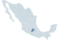
 Temamatla Location in Mexico | |
| Coordinates: 19°12′10″N 98°52′12″W / 19.20278°N 98.87000°W | |
| Kintra | |
| State | Mexico |
| Area | |
| • Total | 28.42 km2 (10.97 sq mi) |
| Population (2005) | |
| • Total | 10,135 |
| Time zone | UTC-6 (Central Staundart Time) |
| • Summer (DST) | UTC-5 (Central Daylicht Time) |
Temamatla is a toun an municipality in the State o Mexico in Mexico. The municipality covers a aurie o 28.42 km².
As o 2005, the municipality haed a total population o 10,135.[1]
References
- ↑ "Temamatla". Enciclopedia de los Municipios de México. Instituto Nacional para el Federalismo y el Desarrollo Municipal. Archived frae the original on 27 Apryle 2007. Retrieved 6 Juin 2009.