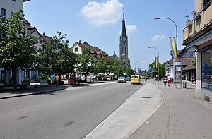
Wetzikon
Appearance
Wetzikon | |
|---|---|
| Coordinates: 47°19′N 8°48′E / 47.317°N 8.800°E | |
| Country | Switzerland |
| Canton | Zurich |
| District | Hinwil |
| Government | |
| • Executive | Gemeinderat with 7 members |
| • Mayor | Gemeindepräsident Urs Fischer FDP/PRD (as of March 2014) |
| • Parliament | Grosser Gemeinderat with 36 members |
| Area | |
| • Total | 16.73 km2 (6.46 sq mi) |
| Elevation | 535 m (1,755 ft) |
| Population (31 December 2018)[2] | |
| • Total | 24,764 |
| • Density | 1,500/km2 (3,800/sq mi) |
| Time zone | UTC+01:00 (Central European Time) |
| • Summer (DST) | UTC+02:00 (Central European Summer Time) |
| Postal code(s) | 8620 |
| SFOS number | 0121 |
| Localities | Ettenhausen, Kempten, Medikon, Oberwetzikon, Robenhausen, Unterwetzikon |
| Surrounded by | Bäretswil, Gossau, Hinwil, Mönchaltorf, Pfäffikon, Seegräben |
| Twin towns | Melnik (Czech Republic) |
| Website | www SFSO statistics |
Wetzikon is a small town of the district of Hinwil in the canton of Zurich in Switzerland. It is near Lake Pfäffikon in the Zürcher Oberland, between Uster and Rapperswil-Jona.

References
[change | change source]- ↑ 1.0 1.1 "Arealstatistik Standard - Gemeinden nach 4 Hauptbereichen". Federal Statistical Office. Retrieved 13 January 2019.
- ↑ Error: Unable to display the reference properly. See the documentation for details.
Other websites
[change | change source] Media related to Wetzikon at Wikimedia Commons
- Official website (in German)


