Minehead
Appearance
| Minehead | |
|---|---|
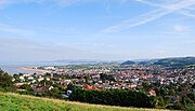
 Minehead viewed from Grabbist Hill | |
| Location within Somerset | |
| Population | 11,981 (2011 census) |
| OS grid reference | SS970460 |
| Civil parish |
|
| Unitary authority | |
| Ceremonial county | |
| Region | |
| Country | England |
| Sovereign state | United Kingdom |
| Post town | MINEHEAD |
| Postcode district | TA24 |
| Dialling code | 01643 |
| Police | Avon and Somerset |
| Fire | Devon and Somerset |
| Ambulance | South Western |
| UK Parliament | |
Minehead is a seaside town and civil parish in Somerset, England. It is in the borough of Somerset West and Taunton.
In 2011, the town had a population of 11,981. It is close to the border with Devon.
The town is 21 miles (34 km) north-west of Taunton, Somerset's county town.
It is close to the Exmoor National Park.
Minehead is famous for being the location of Butlin's Minehead, a popular holiday camp owned by Butlin's.
The town is the starting point of the South West Coast Path, the longest countryside walking trail in the United Kingdom.
Twinning
[change | change source]Minehead has one twin town. It is twinned with:
Saint-Berthevin, France
Gallery
[change | change source]-
Minehead from the west
-
Butlin's Minehead
-
Minehead beach


